SR #33 “At last, we are free from masks!”, “Ruined Castle in Katoomba”, “Narrow Neck Peninsula in Katoomba”
To date, Australia has recorded 29,087 confirmed cases of COVID-19, including 909 deaths.
NSW state government is in process of deregulation concerning COVIT-19, and from this week, wearing mask in public transport is no longer in mandate, but it is still strongly recommended.
Effective 29 March 2021, the number of people allowed to visit at home or gather outdoors has increased. The capacity for businesses and venues has been increased and entertainment venues can operate at 100 percent seated capacity. Restrictions on singing, dancing and nightclubs have been lifted.
As for vaccination, since I belong to the 2nd category of priority [I am over 64, and I have baseline illness of diabetes and high-blood presser], I am qualified to get vaccination next week.
I will add this vaccination to my private precautions against any illnesses including this pandemic. I shall practice proper diet, exercise and vaccination.
But in our daily life, who knows you are safe from any accidents. My fellow hikers, one is Mr. Ra, a member of the Blue Mountains Club, stumbled by stepping his own shoe lace in the mountain, and he hurt his face and hands and knees.
Also, my close friend, Isaac, who is my comrade of trekking the Great North Walk, strained his ankle when he hurried the traffic accident cite where his wife was involved. Fortunately his wife was physically no harm, although their car became a junk completely.
“Ruined Castle in Katoomba”
The most famous sightseeing spot in the Blue Mountains must be “Echo Point” in Katoomba. I guess many of you have visited there if you visited Sydney.
[Three Sisters from Echo Point、エコーポイントから見たスリー・シスターズ、에코 포인트에서 본 세자매 봉]
Sightseeing is one of important industries in Australia. So, it must be a big problem/crisis for many people/businesses. But it seems that NSW government increased many people, esp. young people to work for upgrading its sightseeing spots. Many bushwalk tracks were closed in the Blue Mountains last year. One reason is the bush-fires. I see many young people working jobs of stone mason. And they are re-opening one by one.
Now they have upgraded Echo Point quite well. If you visited there before, please re-visit there. You must be surprise and be pleased.
From Echo Point Lookout, you can see the gigantic view of Jamison Valley. On your left, you can see the famous Three Sisters Rocks. In the middle, you can see the 3 gigantic peaks of the Mount Solitary. On tyour left side, you can see the steep cliff, and several Scenic World facilities such as Scenic World Railway (Cable Car) and Scenic World Skyway (Rope Way).
If you have good eye-sight or a pair of binocular glasses, you can see a small rocky mountain between Mt. Solitary and the Scenic World on the ridge. That mountain is Ruined Castle.
[Ruined Castle from Echo Point,エコーポイントから見たルインド・キャッスル、에코 포인트에서 본 루인도 캐슬]
It was the end of February, it rained hard in the morning. Yet, 5 of Saturday Hikers joined me for this endeavor. I told them if it was raining hard, we would go to see the Katoomba Falls and return. If it stopped raining, we would go as far as we can.
When we arrived at Katoomba station, it stopped raining. We used #686 bus to go to Katoomba Falls. When we got off the bus, it was foggy. We went down to a Jamison Valley Track called “Federal Track” via “Furber Steps.
[Witch's Leap near Katoomba Falls, ウィッチズ・リープ(魔女の滝)、위찌즈 리프 (마녀 폭포)]
When we reached at the bottom of Furber Steps, it was only 10 minute walk to Scenic World Village.
When we walked from the mine exhibition for 15 minutes, we came to “Land-Slide” area. In the ancient era, there must have been a big fall of the rocks from the cliff. This area is the hardest part of this trekking. It may take 30 minutes to pass this area. Then it is relatively an easy trekking to the bottom of the Ruined Castle.
Golden Stairs is in the middle of the way from Land-Slide and Ruined Castle. There is a small recent land-slide just before Golden Stairs.
There is a big antheap at the bottom of Golden Stairs. The surface of the antheap is very hard. But there is some soft part of living antheap. If you scrape the soft part, you can see small termites under the soft surface soil.
[At the antheap at the bottom of Golden Stairs, ゴールデンステアーズのアリ塚にて、황금 계단 흰개미 둔덕에서]
It stopped raining completely when we reached at Golden Stairs and we could see the blue sky then. It was indeed a pleasant trekking.
We arrived at the foot of Ruined Castle at noon. There is a public toilet there. There is an information board there. It says it is only 600 meter climbing until Ruined Castle. But it is a bit steep climbing.
[The information board near Ruined Castel,ルインド・キャッスル近くの案内板、루인도 캐슬 근처의 안내판]
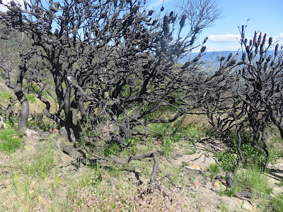
We could see the scars of the bush-fire along the ridge. When we arrived at Ruined Castle, we left our bags and began to climb the castle. It reminded me of Mount Yari in South Alps in Japan. When I reached at the shoulder of Mt. Yari, I left my bag at the lodge named Yarigatake Sanso and climbed the peak of Mt. Yari, a heap of rocks looked like a spearhead.
[At Ruined Castle、ルインド・キャッスルにて、루인도 캐슬에서]
It is indeed a magnificent view you can enjoy from the top of Ruined Castle, just like on the top of Mt. Yari.
There were several young people when we reached there. One of them kindly offered to press the shutter of my camera.
[At Ruined Castle、ルインド・キャッスルにて、루인도 캐슬에서]
We had lunch (bento) on the way back to Katoomba Falls. There was a perfect place to take a rest near the castle on the ridge. It took about the same time (3 hours) to go back to the bus stop.
Total walking distance for the day was 22.8 km, 34,509 steps and 77 floors according to my smartphone.
“Narrow Neck Peninsula in Katoomba”
After climbing Ruined Castle, I saw bunch of beautiful flowers in facebook. Ms. K, a Japanese female hiker uploads very attractive pictures. I learn a lot about tracks and flowers from her uploaded pictures and her descriptions.
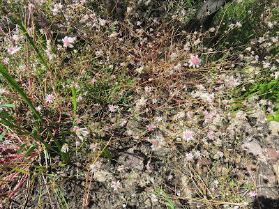
[Pink frunnel flowers, ピンク・フランネル・フラワー、핑크 플란넬 플라워]
According to Ms. K, pink flannel flowers sprout and bloom after bush-fires. Since I had never seen these flowers, I wanted to visit the place: Narrow Neck Trail.
[Bushfire traces、ブッシュファイアーの跡、부시 화재의 흔적]
On facebook, I asked the nearest public transportation point. Then she wrote “Scenic World.” So, I took #686 bus from Katoomba and went to Scenic World.
It is easy to find the trail thanks for the iPhone’s GPS function.
Narrow Neck Trail runs on the ride of Narrow Neck Peninsula which is above “Federal Pass” that leads to Ruined Castle from the bottom of Furber Steps.
[Narrow Neck Trail,ナロウネック・トレイル、나로우넷쿠 트레일]
When I walked this Federal Pass with my Korean friends, we passed the bottom of Golden Stairs.
Actually, I walked to Golden Stairs along Narrow Neck Trai. And Narrow Neck Trail is a fire trail ( a track through forest or bush for use in fighting fires) so it is relatively easy to walk.
There is a nice information board along the track. It shows the whole picture of Narrow Neck Peninsula and flora and fauna there.
Then there is another information board which shows the distances of several destinations (Castle Head 2.5 km, Clear Hill 9.5 km, Tarrows Ladder 11 km, Medlow Gap 12.5 km.) I decided to go the nearest destination: Castle Head, that day.
It was a track-head of bush walk trail. It was partly muddy because of long rainy days. Yet I found a cluster of sundew plants. They are tiny but beautiful reflecting sun shine on the dews on their leaves.
[Cluster of sundews, モウセンゴケの群落、끈끈이 주걱 군락]
After one hour walk from the information board, I reached Castle Head. It is a fantastic place! I could see Sky Walk cables of Scenic World on my right side. Straight ahead, under my kfeet, I could see Ruined Castle along the ridge. Then behind the castle, there are big mountains, the highest peak is Mount Solitary. I could even see the trail which leads to the top of the mountain.
[A view from Castle Head, キャッスル・ヘッドから見た風景、캐슬 헤드에서 본 풍경]
There was no hiker around me. I had my lunch on the edge of the rocky cliff.
It was a “piston” trekking, so I returned to the same way. I took the bus from Scenic World to Katoomba.
It was a 6 hour hike of a fine day. Total walking distance of the day was 18.1 km, 28,924 steps and 54 floors according to my iPhone.
-------------------------------------------------------------------------------------------------------------
SR #33 「いよいよマスクから解放」「カトゥンバのルインド・キャッスル(廃城)」「カトゥンバのナロウ・ネック半島」
現在までのところオーストラリアでは累計で909人の死亡例を含む29,097件の新型コロナ感染者数を記録している。
我々の住むNSW州政府は規制緩和を進め、来月からは教会での社会的距離も2mから1m、映画館の収容可能人数も平常にもどり、なによりも公共交通機関でのマスク着用の義務(mandatory)から推奨(recommended)になる。
コロナ用ワクチンも医療従事者への投与が終わり、来月から次の優先順位グループに投与される。私も高齢者(65歳以上)であり、基礎疾患(糖尿病・高血圧)があるので、GPから受けることを勧められている。
私の個人的な対策としては、基礎体力の維持向上、衛生管理に、ワクチンを受けることが加わる。
さて、どんなに注意していても不慮の事故ということが常にある。青山会の先輩でテコンドー有段者の羅さんが、トレッキング中、登山靴の紐が解け、それを踏んで転倒、顔面や手足に傷を負った。
また、「ザ・グレート・ノース・ウォーク」の同行者で土曜ハイカーズの中で最も熱心なアイザックが奥さんの交通事故の報に現場へ駆けつけた際、足首を痛め、以来活動中止中である。(幸い、交通事故の方は、車は廃車になったが体は無事であったそうである。)
「カトゥンバのルインド・キャッスル(廃城)」
ブルーマウンテンで有名な観光地といえば、「スリー・シスターズ」が見える「エコー・ポイント」で、ここを訪れた人は非常に多いと思う。
昨年初頭にコロナ禍が始まって以来、世界中で観光客の激減現象が起こっているが、危機を機会にとらえる積極性が必要だ。
NSW州では、観光地のアップグレードが盛んにおこなわれている。
この展望台に立って、左側の「三姉妹」から中央に目を移せば、ひときわ存在感のある山が「マウント・ソリタリー」である。
[Mount Solitary from Echo Point, エコーポイントから見たマウント・ソリタリー、에코 포인트에서 본 마운트 솔리터리]
視線を左側に移すと、断崖が見え、よく目を凝らせばシーニック・ワールドの鉄道(ケーブルカー)やロープウェイが見える。
[Railway Station At Scenic World, シーニックワールドのレールウェイ駅、시닉 월드 레일 웨이 역]
この断崖に沿って歩き、さらにマウント・ソリタリーに向かって歩くと中間に小高い丘があり、その頂上に城のようにそびえているのが、「ルインド・キャッスル(廃城)である。
この「ルインド・キャッスル」に行くには、断崖の下のフェデラル・トラックにまず下らなければならない。
我々はシーニック・ワールドに近いカトゥンバ・フォールズでバスを降り、ファーバー・ステップスからこの「フェデラル・トラック」に入った。
[Witch's Leap near Katoomba Falls, ウィッチズ・リープ(魔女の滝)、위찌즈 리프 (마녀 폭포)]
フェデラル・トラックの合流点から、シーニック・ワールドのロープウェイやケーブルカーの渓谷の底にある「シーニック・ワールド・ビリッジ」入口まではわずか10分である。
この辺りには石炭層がいまでもむき出しになっていて、昔の石炭採掘の様子が展示されている。
この展示場を過ぎるとビリッジの右側に続くトラックの入口に出る。ここには厳しいトラックなので技術と装備を持つものだけが自己責任で進むことができるという警告意板がある。
「フェデラル・トラック」はルーラからルーラの森を過ぎ、「スリー・シスターズ」から降りる「ジャイアント・ステアーズ」からの道に合流、さらにカトゥンバ・フォールズ、から降りる「ファーバー・ステップス」に合流するが、このシーニック・ワールドビリッジ」の先までは高低差の少ない快適な道である。
しかし、「シーニック・ワールド・ビリッジ」を過ぎて2kmほど進むと、「ランド・スライド(Land Slide)」と呼ばれる、昔、断崖が大規模に崩れた地帯になる。
ここは、エコー・ポイントの展望台からみると右手の崖の下であり、場所によっては大きな岩をよじ登らねばならない難所である。
ここを過ぎればまた快適な渓谷の底の登山路で、約1時間進むと、最近起こった小規模の土砂崩れでフェデラル・トラックが埋まってしまった場所に出る。ここを谷側に迂回すると「ゴールデン・ステアーズ」の登り口に出る。
ここまでは1か月前に到達しており、大きなシロアリの塚がある。ここから先が新体験となる。
[At the antheap at the bottom of Golden Stairs, ゴールデンステアーズのアリ塚にて、황금 계단 흰개미 둔덕에서]
この朝、雨が降り、バスを降りたときほぼやんだが、深い霧の中を進んできた。しかし、ゴールデン・ステアーズに到着したときは霧も晴れ、シダ類が雨に洗われて新鮮な渓谷を進むことができた。
「ゴールデン・ステアーズ」から約1時間、快適なトレッキングをすると、ルインド・キャッスルの麓にでる。ここには公衆トイレと案内板がある。
[At the information board near Ruined Castle, ルインド・キャッスル近くの案内板にて、루인도 캐슬 근처의 안내판에서]
ここまでくればあと目的地まで一息である。600mの階段を上り、山火事の跡が生々しく残る尾根を進めば、よじ登らねばならないルインド・キャッスルに到達する。
北アルプスの槍ヶ岳に上った時と同様、「廃城」の下に荷物を置き、この岩山に上った。
[At Ruined Castle、ルインド・キャッスルにて、루인도 캐슬에서]
岩山の頂上からの展望は「小鑓」の上からの展望を思い出させるような視界360度の展望である。
[At Ruined Castle、ルインド・キャッスルにて、루인도 캐슬에서]
我々が到着したとき、我々の先客の若者たちが下ってくるタイミングで、彼らの一人が私のスマホのカメラのシャッターを押すことを申し出てくれた。
しばらく岩山の頂上で記念撮影をした後、岩山から下って、風通しの良い尾根で昼食をとり、同じ道を通ってカトゥンバ・フォールズのバス停に戻った。
この日の歩行距離は22.8km、歩数は34,509歩、階段は77階であった。
「カトゥンバのナロウネック半島」
ルインド・キャッスルで素晴らしい体験をした後、フェイスブックで知った日本人の女性ハイカー、Kさんの登山体験投稿から山火事の後に発芽・開花するピンク・フランネル・フラワーを知った。
咲いている場所は、カトゥンバのナロウネック半島を走るナロウネック・トレイル沿いの山火事の跡である。
Kさんはブルーマウンテンのトラックにも花々にもとても詳しい。フランネル・フラワーというのは「ザ・グレート・ノース・ウォーク」のブッシュウォークでよく見かけたが、ピンク・フランネル・フラワーはこれまで見たことがなかった。
[Pink frunnel flowers, ピンク・フランネル・フラワー、핑크 플란넬 플라워]
Kさんによれば、この花は山火事などで燃えた後にだけ発芽するそうで、意識していないと見つからないだろう。
[Bushfire traces、ブッシュファイアーの跡、부시 화재의 흔적]
この日(3月26日)、Kさんに教えていただいた最寄りのバス停、Scenic Worldで下車し、ナロウネック・トレイルをスマホのGPS機能で探した。
ナロウネック・トレイルは、エコーポイントから右側の断崖の上から熱帯雨林の海に突き出ているナロウネック半島の尾根伝いのファイアー・トレイル(山火事の際、消防自動車が走る道)である。
[Narrow Neck Trail,ナロウネック・トレイル、나로우넷쿠 트레일]
地図で見ると歩いたルインド・キャッスルへ続く、フェデラル・パスの上を並行して走っている。
前回、ファーバー・ステップスを下って、フェデラル・パスに合流し、ランド・スライド地帯を過ぎた先にゴールデン・ステアーズの底に出た。このゴールデン・ステアーズの上部がナロウネック・トレイルの途中にある。
ここからさらに15分ほど進むと、ファイアー・トレイルの左側に案内板があり、キャッスル・ヘッドまで2.5kmと記してある。ここからはブッシュウォークである。
先週続いた雨で足場が悪いが、途中、モウセンゴケの群落を見た。モウセンゴケの英語名は「sundew」で「太陽の露」という意味だが、私は陽光を浴びてキラキラ輝いているこの花が好きである。
[Cluster of sundews, モウセンゴケの群落、끈끈이 주걱 군락]
このブッシュウォークは断崖の上であり、転落予防柵のない断崖から下をみると足がすくむ。
キャッスル・ヘッドは視界を妨げるものが何もない、360度の展望をたのしめる断崖の上である。
[A view from Castle Head, キャッスル・ヘッドから見た風景、캐슬 헤드에서 본 풍경]
左をみるとScenic WorldのSky Walkのロープが見える。その先はウェントワースの断崖であろう。
正面の遠方中間を見るとひときわ白く岩が突出しているのがルインド・キャッスルであり、その先に存在感のあるマウント・ソリタリーがでんとかまえてる。
マウント・ソリタリーの右側には湖のような水面がみえ、さらに続く断崖はブラックヒースの断崖だろうか。
最高の景色を独り占めにして、断崖の上の岩場でランチにした。
シーニックワールドのバス停から片道3時間、往復6時間で、この日の歩行距離は18.1km, 歩数は28,924歩、階段は54階であった。
I like hiking very much. I used to go hiking with a Korean hiking club named “AhToSan.” This blog introduces mostly my hiking activities in Korea and Japan, and Sydney in Australia. As of January 2020, I live in Sydney suburb. I go Blue Mountains and bush walk in Sydney area. 私は2003年から2014年まで韓国の大田(テジョン)に住んだ日本人である。11年間、週末は主に「アトサン山岳会」に参加した。14年4月に帰国したが、2020年以降はおもにシドニーで暮らし、時折、日本へ帰国する程度である。したがって最近の記事はSR(Sydney Report)としてブルーマウンテンのトレッキングを中心に書いている。
About pictures/当ブログ内の写真について/당 블로그내의 사진에 대해서
Most of the pictures in this blog are taken by my camera, yet some of them were downloaded from the website of the hiking club. If you click any pictures, they become the original size.
当ブログ内の写真の大部分は筆者のカメラで撮影したものですが、一部、山岳会の共有写真からダウンロードしたものを含みます。すべて、各写真をクリックすれば、元のサイズに拡大します。
당 블로그내 사진의 대부분은 필자의 카메라로 촬영한 것입니다만 일부 산악회 공유 사진으로부터 다운한 것도 포함합니다. 모두 각 사진을 클릭하면, 원래 사이즈에 확대합니다.
当ブログ内の写真の大部分は筆者のカメラで撮影したものですが、一部、山岳会の共有写真からダウンロードしたものを含みます。すべて、各写真をクリックすれば、元のサイズに拡大します。
당 블로그내 사진의 대부분은 필자의 카메라로 촬영한 것입니다만 일부 산악회 공유 사진으로부터 다운한 것도 포함합니다. 모두 각 사진을 클릭하면, 원래 사이즈에 확대합니다.


