About pictures/当ブログ内の写真について/당 블로그내의 사진에 대해서

Most of the pictures in this blog are taken by my camera, yet some of them were downloaded from the website of the hiking club. If you click any pictures, they become the original size.

当ブログ内の写真の大部分は筆者のカメラで撮影したものですが、一部、山岳会の共有写真からダウンロードしたものを含みます。すべて、各写真をクリックすれば、元のサイズに拡大します。

당 블로그내 사진의 대부분은 필자의 카메라로 촬영한 것입니다만 일부 산악회 공유 사진으로부터 다운한 것도 포함합니다. 모두 각 사진을 클릭하면, 원래 사이즈에 확대합니다.

2020年1月30日木曜日

SR #19 “Trekking at Berowra” and “Bush-Fires & Blue Mountains” 「ベロウラ・トレッキング」および「ブッシュ・ファイアとブルーマウンテン」

SR #19 “Trekking at Berowra” and “Bush-Fires & Blue Mountains”

I came back to Sydney on December 23. While I was in Japan, I heard a lot of bush-fire catastrophes in Australia, esp. in NSW.

The main causes are long-lasted drought, careless handling of fire and even arsons which I cannot believe.

The next day of my arrival, my Korean hiking friends invited me for the bush-walk, not in Blue Mountains, but Berowra near Ku-ring-gai Chase National Park.

[Berowra Trekking]

According to Wikipedia, “Berowra” means a lot of shells in aboriginal language. No wonder there are many shells (mostly oysters) along the track beside the bay.

We (Korean Saturday Hikers) used to meet at Strathfield Square, but this time we met at the platform of Epping Station.
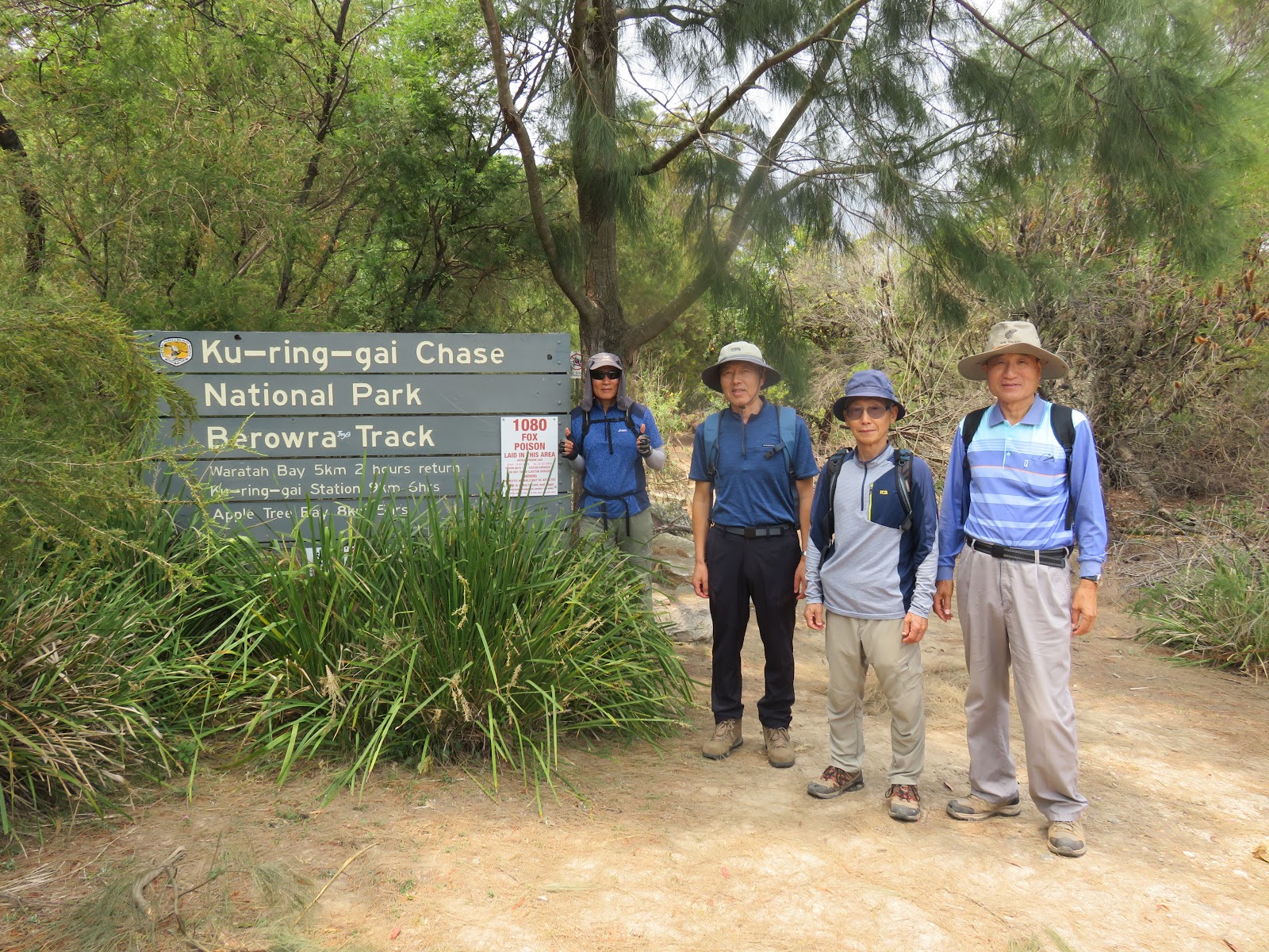
[At the entrance of Berowra Track,ベロウラ・トレッキング入口にて、베로우라 트레킹 입구에서]

Berowra is much close than Blue Mountains, it is only 40 minute train ride from Chatswood where our shared house is located.

The trains run on the plateau like Blue Mountains, so we have to go down from the station to the tracks along the bay.

[On the track in Berowra, ベロウラの登山路にて、베로우라 등산로에서]

I like the views along the bay, as well as the views of canyon in Blue Mountains.

The views of saling boats and ships are nice, and for this particular tracks I expect to see “Goanna” a relatively big lizard in Australia.

[A goanna, Australian lizard, 「ゴアナ」オーストラリアオオトカゲ、"고아나"호주 모니터 도마뱀]

I saw several of them before. But this time, only one.

We walked for about 3 hours, and finished our trekking at Mount Ku-ring-gai Station. And I enjoyed a cool mug of draft-beer with some of the members at a sports-bar near Chatswood Station.

[At a sports-bar after the hike, トレッキングの後にスポーツバーにて、트레킹 후 스포츠 바에서]

Summing up of the walk: Dictance 15 km, Steps: 25,000, Stairs: 50 floors.

[Blue Mountains]

It’s been one month passed since I came back to Sydney. Fortunately we got much rain in January.

I constantly go to Blue Mountains, say, 2 or 3 times a week. Until the 2nd week, many of the tracks in Blue Mountains were closed due to the fire.

On 14 of January, when I went to Parramatta Station, there was no member of "Blue Mountains Club" at the station.

So, I went to Wentworth Falls alone and found out that “Charles Darwin Walk” was closed.

[Charles Darwin Walk was closed./チャールズ・ダーウィン・ウォークは閉鎖された。"찰스 다윈 워크"는 폐쇄되었다.]

I gave up this course and went to “Conservation Hut” a mountain café where many hikers visit.

[Conservation Hut Cafe, コンサベイションハット・カフェ、 콘사 베이션 산장 카페]

It was open and I went to Queen Victoria Lookout where you can get a good view of Blue Mountains.

I saw 4 or 5 smoke coming up from the forest. But I went down to Empress Falls from there.

[A view from Victoria Lookout, クイーン・ビクトリア展望台からの展望、퀸 빅토리아 전망대에서의 전망]

I had lunch at the bottom of waterfall and walked “Nature Track Circuit” and went back to Wentworth Falls Station.

["Edinburgh Rock" along Nature Track, ネイチャー・トラックの「エディンバラ・ロック」、네이처 트랙의 "에딘버러 록 " ]

Walking Distance: 12 km, Steps: 18,000 and 60 Floors.

After this hiking, we had several rainy days, and a week later, I went to Parramatta Station again.

There I saw President Chu (90) at the station and Mr. Min (92) and other members of Blue Mountains Club on the same train.

[Members of Blue Mountains Club, 「青山会」の会員たち、"청산회"의 회원들]

So I walked with them from Wentworth Falls station to Conservation Hut. They walk the short cut track while I walk much longer track alone.

[In front of Conservation Hut Cafe, コンサベイションハットの前にて、콘사베이션 산장 앞에서]

I went to Queen Victoria Lookout first. I saw no smoke from the forest any more.

[At Queen Victoria Lookout, クイーン・ビクトリア展望台にて、퀸 빅토리아 전망대에서]

Then I went down to Empress Falls and then walked to Wentworth Falls Track, about 7-8 km track one way. I climbed “Slacks Ladder” and then National Pass Steps(about 500 steps) and then walked Charles Darwin Walk and came back to Wentworth Falls station.

[At the bottom of Empress Falls, エンペレス・フォールズにて、엔뻬레스 폭포에서]

[Slacks Ladders at Wentworth Falls, ウェントワース・フォールズのスラックス・ラダー、웬트워스 폭포의 바지 사다리]

[At the 2nd bottom of Wentworth Falls, ウェントワース・フォールズの二番底にて、웬트워스 폭포의 두 번째 바닥에서]

[The upper part of Wentworth Falls, ウェントワース・フォールズの最上部、웬트워스 폭포 상단]

Total Waling Distance: 15 km, Steps: 23,000 and Stairs : 95 floors.

Sydney summer is much more comfortable compare to Kanto summer in Japan. Daily temperatures, most likely: 18 – 25℃.

The altitude of Blue Mountains is about 1,000 meters. So, I fell even cooler.

But what we need is rain. Long period of drought makes many plants so dry that makes bush-fire uncontrollable.

I feel so sorry about people who lost their lives and properties, and many wild animals: victims of catastrophic bush-fires.

Recently Sydney Japanese Society did fund-raising activities and contributed the fund to the wild animal protection group called “WIRES.”

[Bush Fire Relief Fundraiser Activities、森林火災被害者のための基金活動、산불 피해자 (동물)을 위한 기금 활동]

[Selling raffle tickets for funds,「ラッフル・チケット」販売、"복권 티켓 '판매]

[Japanese choir sang Japanese songs,日本人合唱団による合唱、일본인 합창단에 의한 합창]

[Japanese Hawaiian dancers, 日本人のハワイアンダンス、 일본인 하와이안 댄스]

I read the news about bush-fires and damages. Here it says about 80 % of Blue Mountains burn and lost, but I cannot believe that, because, I go there 2 or 3 times a week and I never saw bush-fire at all.

All I saw was a partial burn and some smokes. That’s all.

Anyhow, I hope God sends more rain so that bush-fires will completely be put out here in Australia.

----------------------------------------------------------------------------------------

SR #19号 「ベロウラ・トレッキング」および「ブッシュ・ファイアとブルーマウンテン」

12月23日朝、シドニー空港へ到着。約6カ月ぶりのNSWである。オーストラリアでは9月に発生した森林火事が現在もNSWだけでも100カ所で続いているというニュースを聞いた。

この原因は干ばつが続いていることと、タバコやバーベキューの火不始末や、あろうことか放火なども取りざたされている。

[ベロウラ・トレッキング]

到着した翌日、さっそく土曜日の韓国人ハイカーから連絡があり、ブルーマウンテンではなくシドニーから38km北のベロウラ(Berowra)へ行くことになった。ここはクリンガイ・チェイス国立公園に近い。

[At the entrance of Berowra Track,ベロウラ・トレッキング入口にて、베로우라 트레킹 입구에서]

ベロウラとはアボリジニーの言葉で「多くの貝殻」という意味で、どおりで、入り組んだ湾にそってのトラックには牡蠣の殻が大量に見つかる。

今回はいつものストラスフィールドではなく、近郊のエッピング駅に集合し、そこからホーンズビー経由でベロウラへ行くことになった。私の最寄駅チャッツウッドからベロウラまでわずか40分である。

[On the track in Berowra, ベロウラの登山路にて、베로우라 등산로에서]

ブルーマウンテンの列車と同様、駅は高地にあるので、クリークまでひたすら下る。

あとはクリーク沿いにアップル・トリー・ベイまで進み、そこで昼食を食べ、今度は急坂を上ってマウント・クーリンガイ駅に出る。

このコースではクリーク沿いのトラックでグアナ(オーストラリアオオトカゲ)を見かけることが多い。今回は1匹だったが、以前は3匹以上見かけたことがある。

[A goanna, Australian lizard, 「ゴアナ」オーストラリアオオトカゲ、"고아나"호주 모니터 도마뱀]

ところで、仲間とハイキングをして楽しみのひとつは、終了後の冷たいビールの1杯である。この日は、チャッツウッド駅前のスポーツバーで、都合のよいリーさんとキムさんと3人で打ち上げをした。これは楽しみの1つである。

[At a sports-bar after the hike, トレッキングの後にスポーツバーにて、트레킹 후 스포츠 바에서]

運動量は歩行距離約15km、歩数25,000歩、階段50階相当なので中の上ぐらいだろうか。

[ブルーマウンテン]

さて、私がシドニーに戻って約1カ月が経つが、今月に入って雨の日が多い。1月上旬では森林火災のために立ち入り禁止となったトラック(登山路)がかなり多かった。

90歳の朱会長が率いる「青山会」の人々に会おうとして1/14(火)に集合場所のパラマッタ駅待合室に行ったがこの日は一人の会員もこなかった。

やむを得ず一人でウェントワース・フォールズ駅で下車し、チャールズ・ダーウィン・ウォークへ向かったが、このコースは森林火災の恐れのため閉鎖されていた。

こちらをあきらめてコンサベイション・ハットと言うカフェに向かうと、この周囲のトラックは一部開放されている。開放されているネイチャー・トラックを歩くことにした。

コンサベイション・ハットから10分ほど下った、ブルーマウンテンの見晴らしのきくクイーン・ビクトリア展望台へ行くと、たしかにブルーマウンテンの森の複数から煙が立ち上っていた。

[A view from Victoria Lookout, クイーン・ビクトリア展望台からの展望、퀸 빅토리아 전망대에서의 전망]

この日は展望台の下のエンプレス・フォールズまで下り、ここで弁当を食べて、ネイチャー・トラック・サーキットを巡り、ウェントワース・フォールズ駅に戻った。

[At the bottom of Empress Falls, エンペレス・フォールズにて、엔뻬레스 폭포에서]

この日の運動量は距離12km、歩数18,000歩、階段60階相当だった。

この後、数日続けて雨が降り、一週間後の1/21へパラマッタ駅へ行ってみると青山会の朱会長がいた。今年93歳になる一番の長老の閔さんもいた。心からうれしかった。

[Mr. Chu, the president of the club, 青山会の朱会長、청산회의 추 회장님]

この日は、チャールズ・ダーウィン・トラックも開放されていて、朱会長や閔さんたちとはコンサベイション・ハットまで同行した。

ここで青山会のみなさんとは別れ、クイーン・ビクトリア展望台へ行くと1週間前に見えた煙はすべてなく、もはやこの方面の森林火災は収まったようだ。

[A view from Victoria Lookout, クイーン・ビクトリア展望台からの展望、퀸 빅토리아 전망대에서의 전망]

この日はエンプレス・フォールズからウェントワース・フォールズ・トラックを経て強烈なスラックス・ラダーという転落防止用のケージ付きの階段を上った。

[Slacks Ladders at Wentworth Falls, ウェントワース・フォールズのスラックス・ラダー、웬트워스 폭포의 바지 사다리]

さらに500段以上の階段を上がって、ウェントワース・フォールズの最上部に出て、チャールズ・ダーウィン・ウォークをあるき、トータル4時間のトレッキングを実行した。

[The whole picture of Wentworth Falls, ウェントワース・フォールズの全体像、웬트워스 폭포의 전체 상]

[The upper part of Wentworth Falls, ウェントワース・フォールズの最上部、웬트워스 폭포 상단]

この日の運動量は15km、23,000歩、95階相当であった。

ところでシドニーの夏は関東地方の夏に比べ、かなり過ごし良い。気温は18~25℃程度の日が多く、これまで30℃を超えた日は3日のみである。

特にブルーマウンテンは1000mを超える高地になるので駅に降りると肌寒いほどである。

旱魃は現実のもので、多くの植物、とくにシダ類が枯れているのを目撃した。

そのようなわけで最近の雨は慈雨であり、さらに必要なのかもしれない。

1月は学校は夏休み中で、文化活動も休会が多く、私はもっぱら、トレッキングと、列車内での読書三昧の日々である。

トレッキングでは上記のオオトカゲのほか、最近では野生のカンガルーに遭遇したのもラッキーであった。

[A kangaroo at Mt. Victoria, マウント・ビクトリアにてカンガルー、마운트 빅토리아에서 본 캥거루]

PS

 ネットで検索すると様々な情報が入ってくる。

https://marucure-picks.com/accident/bushfire-2/

その中で「世界遺産ブルーマウンテンの森林の80%が焼失」には強い疑問がわく。私は週に3回、ブルーマウンテンに出かけているが、ただの1度も火災は目撃していない。

 しかし人的被害を含め、野生動物の被害も事実だろうと思う。シドニーの日本人社会は「野生動物保護」活動を支援するために今週募金活動をした。チャッツウッドのモールで日本語のコーラスやデュエット、それにハワイアンバンドによる演奏とダンスを披露した。妻が熱心にかかわり、集まった寄付金は「WIRES」に渡した。

[Bush Fire Relief Fundraiser Activities、森林火災被害者のための基金活動、산불 피해자 (동물)을 위한 기금 활동]

[Selling raffle tickets for funds,「ラッフル・チケット」販売、"복권 티켓 '판매]

[Japanese Hawaiian dancers, 日本人のハワイアンダンス、 일본인 하와이안 댄스]

2019年12月26日木曜日

KR #6 Climbing Two Mountains in Iwaki City and Recovery from the Disasters in Fukushima.いわき市の「赤井岳(605m)」と「二ツ箭山(ふたつやさん710m)」登山と福島の震災復興

KR #6 Climbing Two Mountains in Iwaki City and Recovery from the Disasters in Fukushima.

My wife and I have two sons; the elder son, Hajime with his family, living in Sydney, and the younger son, Ryo, now living in Tomioka-machi, Fukushima Prefecture, Japan.

Ryo studied environment science in NZ, and he has been working at NPOs supporting the recovery of the area of Tsunami and Nuclear Plant Accident since 2011.

He got married 3 years ago, and they got a baby this March.

He determined to work at the NPOs in Fukushima and moved in Tomioka-machi with his family this September.

So, before going back to Sydney, I visited Ryo, our younger son, and his family in Tomioka-machi, Fukushima Prehecture.

[JR Special Limited Train "Iwaki" at Shinagawa Station, 品川駅にて「JR特急いわき」시나가와 역에서 JR 특급 "이와키"]

I met them in front of JR Iwaki Station and Ryo drove us to “Akaidake-Yakushi” temple on Mt. Akai in Iwaki city.

The temple was founded in 806, after an earthquake and famine in 734, so the people in Tohoku area have history of having earthquakes for many years.

[A view from "Akaidake Yakushi", 閼伽井嶽薬師からみたいわき市方面、아카이다케 약사에서 본 이와키시 방면]

Ryo drove his car near the peak of the road, then he parked beside the road and we walked a gentle ridge to the top of the mountain.

It was only 30 minute walk, yet I was a little bit surprised that he carried the 8 month old daughter, Kyo, by his hand, and walked the trail rather easily.

[Ryo's family on the ridge trail, 閼伽井嶽山頂への登山路にて、아카이다케 정상에 등산로에서]

So this was a three-generation hike, for the first time for me. We had snack near the peak of Mt. Akai.

[My son and granddaughter at the top of Mt. Akai, 閼伽井嶽山頂にて、아카이다케 정상에서]

After the light hike, we went to a fresh market called “Yattchaba” in Iwaki city.  They sell fish and vegetables.

[At the market called "Yacchaba" ,「やっちゃ場」市場にて、"얏챠바"시장에서]

I was surprised to find “Kamakura Vegetable” corner there. We had lunch at a restaurant there. I had “Kaisendon” and it was delicious.

[The sign board of "Kamakura Vegetable,「鎌倉野菜」の看板、"가마쿠라 야채"의 간판]

[A set menu called "Kaisen-don", 海鮮丼定食、해물 덮밥 정식]

Ryo has two jobs now. He works at an NPO called “Futasuke” and his new job at a hotel called “Hojinkan.”

He works night shift at the hotel, so he went to the hotel to work that day (Dec. 5.)

Next day (Dec. 6) after coming back from work, he drove to Iwaki city again, and we went to Mt. Futatsuya (710m).

Mt. Futatsuya is one of 30 famous mountains in Fukushima. He drove his car to the foot of this mountain.

He parked at a shrine called “Kirigaoka Ohyama Shrine” and we walked “Kirigaoka Forest Road” for about 2 km, close to the peak.

[“Kirigaoka Ohyama Shrine”, 桐ヶ岡大山祗神社、키리가오카 오오야마 신사]

The forest road was closed because of land slide near the shrine. So there was no automobile traffic at all. We enjoyed the gentle hike until the entrance of the trail which leads to the peak.

[We walked the forest road, 我々は林道を歩いた。우리는 임도를 걸었다.]

It was past noon when we reached at the entrance of the trail, so we had a light snack, then we started the mountain hike.

[Autumn colors along the forest road, 林道から見た紅葉、임도에서 본 단풍]

It was a ridge trail, and it took only 30 minutes to reach the peak.

[The Peak of Mt. Futatsuya、二ツ箭山山頂、후타쯔야 산 정상]

After taking pictures, we went down to the rocky part of the mountain. There is an area where chains are facilitated. (I read an article reporting a deadly accident recently.)

So we returned to the fork point and chose a safer trail called “Gassan Trail."

“Gassan” means “Moon Mountain” and there is a big mountain called Gassan (1,984m) in Yamagata Prefecture. It is one of One Hundred Famaus Mountains in Japan. (I climbed this montain several times.)

[Gassan Shrine at Mt. Futatsuya, 二ツ箭山の月山神社、후타쯔야 산 의 갓산 신사]

The views from the shrine were wonderful. We could see “Male Rock” and “Female Rock” where chains were facilitated. But it blew a bit hard and I felt chilly there.

[A view of Male Rock and Female Rock, 「男岩」と「女岩」、"남자 바위" 과 "여자 바위"]

I felt like challenging to climb these rocky area, but not this time. We went down to the forest road, and then to the car.

Ryo drove back to Tomioka-machi and on the way back he showed me the facilities related to the recovery from the disasters.

On the third day of my visit (Dec. 7,) I was to leave Tomioka before noon. My son, guided the tsunami and nuclear plant accident affected area by car.

[Abolished elementary school named "Ukedo", 廃校となった「請戸小学校」、폐교가 된 "우게도 초등학교 "]

He drove through the area where the whole village was disappeared. They are putting nuclear contaminated materials and they built factories where they burn low-level radioactive waste in many of such areas.

[Memorial Plate for Tsunami Victims of Namie-machi,浪江町震災被害者のための慰霊碑、해일 피해자를위한 위령비]

As of December 2019, there are still 3 local towns are designated as “living prohibited areas” next to Tomioka-machi: Ohkuma-machi, Futama-machi and Namie-machi.

[Villages were disappeared after the tsunami attached, 津波襲来後消滅した地域、 해일 내습 후 소멸 한 지역]

Joban Line which connects between Nippori in Tokyo and Iwanuma in Miyagi Prefecture via Ibaraki and Fukushima Prefectures is still being disconnected between Tomioka Station and Namie Station.

[TEPCO Decommissioning Archive Center, 東電廃炉資料館、도쿄 전력 폐로 자료관]

There are three stations; “Yorunomori Station,” “Ohno Station” and “Futaba Statiion” which are under construction now.

They plan to complete this work in 2020, and Joban Line will be reconnected next year.

I pray that God bless Ryo and his colleagues' endeavor and protect them and their families and local citizens from all harms especially for their health.

---------------------------------------------------------------------------------------

KR#6 いわき市の「赤井岳(605m)」と「二ツ箭山(ふたつやさん710m)」登山と福島の震災復興

私には息子が二人いる。長男はオーストラリアで教育を受け現地で就職し結婚し子供が4人いる。

次男はNZで環境学を学び、卒業後は環境保護のNPO活動に携わり、2011年の大震災以降は福島の復興にかかわってきた。

次男は2016年2月に結婚し、今年3月14日に待望の第1子が生まれた。

[My second son, Ryo's family at Akaidake Yakushi Temple, 伽井嶽薬師境内にて次男一家、아카이다게 약사 경내에서 차남 일가]

次男一家は今年9月、福島県双葉郡富岡町の町営住宅に移住した。

次男はこれまでの復興にかかわるNPOを継続する一方、地元の企業に職を得た。

今月第1週、シドニーへ戻る前に、2泊3日で富岡町の次男一家を訪ねた。

初日は富岡へ行く手前の「いわき」で合流し、いわきの閼伽井嶽薬師(あかいだけやくし)およびその裏山である赤井岳(605m)に登頂した。

閼伽井嶽薬師は大同元年(806年)開基。その契機となったのは天平6年(734年)に東北地方で起こった大地震や飢饉というのでこの地の災害の歴史は実に長い。

閼伽井嶽薬師は赤井岳の山頂近くにあり、境内からいわき市の街並みが展望できる。山の紅葉も残っていてよかった。

[Autumn colors at Akaidake-yakusi, 閼伽井嶽薬師の紅葉、아카이 다케 약사의 단풍]

寺の坊さんに登山口を訪ね、峠の分岐点に車を止め、片道30分の尾根歩きで山頂に到着した。次男は、8カ月になる娘を軽々と抱いて、私の先を歩いた。

私にとって3世代登山は初めてである。山頂でブルーシートを敷いてスナックを食べて満足である。

[At the top of Mt. Akai, 閼伽井嶽山頂にて、아카이다케 정상에서]

下山していわき市の台所と言われる鮮場「やっちゃば」という市場を訪れた。ここは新鮮な野菜多魚介類をかなり安価に販売している。

[The Shiome Restaurant in the market, 市場の中の「潮目食堂」、시장에서 "시오메 식당"]

野菜市場では「鎌倉野菜」のコーナーを見つけ驚いた。私は市場内の食堂で海鮮丼をごちそうになった。食材が新鮮でとてもおいしかった。

[A set menu called "Kaisen-don", 海鮮丼定食、해물 덮밥 정식]

現在息子はこれまでのNPO以外にもホテルで働いており、この日は夜勤で、夕方、職場のホテルへ出勤した。

翌日、夜勤明けにも関わらず、ふたたびいわき市まで車を運転し、より本格的な、「二ツ箭山(ふたつやさん710m)」に案内してくれた。

二ツ箭山はコースによっては山岳事故も起こるほどの山で、中級向けとされている。

https://yamayama.jp/futatsuya/futatsuya.htm

次男もこの山に登るのは初めてなので、まず、登山口をさがした。

登山口は「根本登山口」を探し、桐ヶ岡林道の起点近くの桐ヶ岡大山祗神社の前に車を止めた。

[At the starting point of the forest road, 林道の起点にて、임도의 기점에서]

我々は桐ヶ岡林道を2kmほど上った峠から山頂に向かった。この林道は起点からすぐ50mくらいのところで土砂崩れがあり、車は通れない。我々はみごろの紅葉を愛でながらのんびりと歩いた。

[We walked the forest road, 我々は林道を歩いた。우리는 임도를 걸었다.]

峠の登山口で軽いランチを食べ、この登山口から山頂までの尾根をゆっくり歩いて30分ほどで山頂についた。

[Lunch at the entrance of "Pass Track", 桐ヶ岡林道峠登山口にて昼食、키리가오카 임도 고개 등산로 입구에서 점심]

[At the top of Mt. Futatsuya,二ツ箭山山頂にて、후타쯔야 산 정상에서]

山頂から鎖場まで下り坂を歩いた。さらに直進すると死亡事故のあった鎖場に出るが、今回はこれを避け、分岐まで戻ってから比較的安全は月山尾根を選んだ。

「月山神社」とは日本百名山の1つである山形県の月山(1,984m)にある月山神社と関係があるようで、同じ名称の小さな神社が月山尾根コースにあった。

[Gassan Shrine at Mt. Futatsuya, 二ツ箭山の月山神社、후타쯔야 산 의 갓산 신사]

ここならの展望はすばらしく、鎖場がある「男岩」「女岩」が見える。しかし、ここは風が強く、かなり肌寒く感じた。

[A view of Male Rock and Female Rock, 「男岩」と「女岩」、"남자 바위" 과 "여자 바위"]

鎖場のあるコースを上るのは次回のお楽しみということで、今回は桐ヶ岡林道へ出て、車で富岡へ戻った。ほぼ3時間の無理のない登山だった。

次男は富岡町にもどる道すがら、復興に関連した施設を案内してくれたのも自分にとっては彼の今後の生活を知るうえで有益だった。

さて、彼らのアパートに2泊して、3日目(12月7日)は電車で鎌倉へ戻ったが、その前に次男は震災関連個所を車で案内してくれた。

[Abolished elementary school named "Ukedo", 廃校となった「請戸小学校」、폐교가 된 "우게도 초등학교 "]

津波で町が消滅した地域は現在核廃棄物の焼却炉や一時貯蔵場所になっていてその処理がまだ延々と続いている。

[Memorial Plate for Tsunami Victims of Namie-machi,浪江町震災被害者のための慰霊碑、해일 피해자를위한 위령비]

現在(2019年12月)なおも帰還困難区域に指定されているのは富岡町に隣接した大熊町、双葉町、浪江町の3町で、常磐線では富岡駅と浪江駅間が不通である。

[Joban line diagram showing disconnected section,不通区間を示す常磐線路線図、불통 구간을 나타내는 조반 선 노선도]

この間の夜の森駅、大野駅、双葉駅の3駅は復興工事が進行中で2020年には全線が復活するという。

[TEPCO Decommissioning Archive Center, 東電廃炉資料館、도쿄 전력 폐로 자료관]

息子はこれらの関連地域を車で案内してくれた。このような働きも彼のNPO関連の仕事の一環らしい。

息子の働きが主に祝され、息子一家、同僚たちおよび地域の方々の健康が守られるよう祈ってやまない。