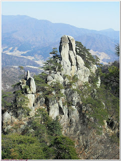
Destination (mountain): Mt. UnAkSan (937.5m). Pocheon, Gyonggido
Hiking course: Hapalli – ByongBungBawi – DongBong - Child Rock - ShinSonDae – UnAkSan Parking Lot (8km, 5 hours)
Partner: About 40 (4 foreingers including myself: India, USA, and 2 Japanese)
 [At Hapalli Entrance, ハパリ登山口にて、하팔리 등산구에서]
Mt. UnAkSan is one of the best 100 Korean mountains. It is also one of Five-Gyongi-AkSans. “AkSan” means rocky mountain. Therefore we could enjoy rocky sceneries, just like famous Seoraksan or Kumgansan.
 [Nice view of Mt UnAkSan, 雲岳山の景観、운악산(雲岳山)의 아름다운 모습]
 The mountain is relatively close to Daejeon, but in order to avoid traffic jam, we started at Expo South Gate in Daejeon at 6 a.m., one hour earlier than usual.
We arrived at the entrance of the trail in HaPalli at 9:20 a.m.
I climbed this mountain with AhToSan in July 2006, but this time, it was completely the otherway around. So, we began climbing where I came down last time.
We arrived at the first view point called “HongPok” which means “Scarlet Waterfall” at 9:40. The next view point which was under the cliff at 10:00 p.m. We had a short rest-time, they call “Suzuki Time” there. I provided Chili grapes and Chinese oranges, while the other members provided makgeolli, the Korean rice wine.
 [Makgeolli, Chili grapes and Chinese oranges, マッコリと青ブドウとキンカン、막걸리와 청포도와 금귤]
Up to this moment, I walked with Masashi, who is a colleague of Bernardo and Soumen. These three foreigners are working at KASI (Korea Astronomy and Space Science Institute.) Masashi worked for KASI for about one year, and will soon return to Japan within a month. Actually it was his last hike with AhToSan.
After “Suzuki Time,” we soon came to the really rocky area, and then we came to the ridge where we could have a great command of views.
We enjoyed taking pictures of the views and portraits, then we came to the northen part of the mountain. It was rather a steep slope covered with snow and ice. So, some members began wearing climbing irons. I had these gears, but I climbed this icy slope without wearing climbing irons. I used my hands and to hold one tree to another, just like some other members.
 [Srop covered with snow and ice, 雪と氷の斜面、눈과 얼음의 경사면]
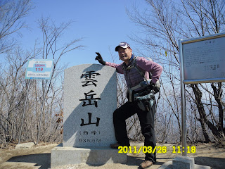
 Then we came to another ridge with some snow remained. It was close to the West Peak of UnAkSan. We arrived at the peak at 11:15. Then to the East Peak of UnAkSan at 11:25. We had lunch at the East Peak of UnAkSan.
 [At the East Peak of UnAkSan, 雲岳山の東峰にて、운악산 동봉에서]
UnAkSan is close to Seoul. Therefore, 6 people including Chris and his girlfriend, came from Seoul. They arrived at the same peak at around noon. So, we all got together, and took several pictures. They joined a part of AhToSan members who arrived at the peak, last.
 [Lunch on the top of the mountain, 山頂にて昼食、정상에서 점심식사]
I joined the top group and began decending the mountain first. The decending course was also nice. We enjoyed beautiful sceneries with nice rocks here and there. The magnificent rock called “Mirok Rock” was especially nice.
 [On the ridge, 稜線にて、능선에서]
 [Mirok Rock on the way to decend, 下山路の弥勒岩、하산길의 미륵바위]
I walked with Masashi and Soumen until the goal via an old temple named “HyonDeungSa.” There were a lot of restaurant on the both sides of the road which leaded to the temple. Many hikers as well as sightseers may enjoy eating and drinking traditional Korean foods/drinks at such restaurants.
 [With Masashi and Soumen on the decending trail, 下山路にてマサシおよびソーメンと、하간길에서 마사시와 서우멘]
 [The mountain gate of HyonDeungSa, 懸燈寺の山門にて、현등사 산문앞에서]
Anyway, I arrived at the bus in the parking lot at 2:30 p.m. The last hiker arrived at 3 p.m. We enjoyed “Wrap-up” party with “Chokpal” or “pork hock” and “Deodeok Makgeolli” or “Korean traditional rice wine.”
 [Chris and his girlfriend at "Wrap-up Party," クリスとGFもティップリに参加した。크리스와 여자친구도 뒤풀이에 참가했다.]
Soumen did not like makgeolli, but all other foreingers enjoyed the drink. After the party, 6 people from Seoul went back to Seoul, while the rest of us headed for Daejeon. We arrived at Expo South Gate at 7:30 and it was my 18th hike for this year (also my 233rd hike with AhToSan.)
登山月日:2011年3月26日(土)、快晴
登山地:京義道・雲岳山(ウナクサン운악산937.5m)
登山コース:下板里(ハパルリ하판리)-屏風岩(병풍바위)-雲岳山[西峰(ソボン) - 東峰(トンボン)]-子供岩(エギパウィ)-神仙台(シンソンデ)-雲岳山(ウナクサン)サービスエリア(約8km, 5時間)
同行者:アトサンメンバー40人弱。外国人はインド人ソウメンと久しぶりに参加した天文研究院のマサシと私の他、ソウルから別ルートで参加した米国人クリスの4人。
今回の登山は、京義道抱川(ポチョン포천)市の雲岳山(ウナクサン운악산)(937.5m)で、韓国100名山の1つ。また、京義五岳の1つでもある。
韓国では山の名前に「岳」の字が入ると、岩山である。この山も奇岩がすばらしい景観を作って、雪嶽山や金剛山のように見える部分もあった。
 [Nice view of Mt UnAkSan, 雲岳山の景観、운악산(雲岳山)의 아름다운 모습]
 バスがソウル近郊を抜けるために、出発は平常より1時間早く、南門を6時。抱川の下板里(パパルリ)登山口に到着したのは9時20分だった。
雲岳山は2006年7月に登っているが、この時はまったく逆のコースだった。今回はきれいに整備された木製の階段を登り、以前、下山した見覚えのある丘陵から登りはじめた。
最初の景観ポイント、虹瀑(ホンポク홍폭)には9時40分に到着した。虹瀑を過ぎて次のポイントである絶壁の下の亭子に着いたのは10時ごろだった。ここで、恒例のスズキタイム。
 [A short break under the cliff, 崖の下で小休止、절벽 아래에서 짧은 휴식]
 今回、私は種無し青ブドウとキンカンをそれぞれ2ボックス持参。アランドロンらがマッコリを提供。この辺までは来週日本へ帰国するため、今回がアトサン最後となるムサシとよもやま話をしながら進んだ。
その後、両手を使わなければ困難な岩場の登りを過ぎるとすばらしい景観の尾根に出た。しばらく写真を撮ったり撮られたりしながら進むと山の北側のやや急な斜面に出た。
この谷間は一面雪と氷で覆われていてアイゼンが必要とも思われたが、斜面につかむのに都合の良い直径10センチ程度の灌木が多く生えていたため、これらをつかみながら登った。
 [Srop covered with snow and ice, 雪と氷の斜面、눈과 얼음의 비탈진 면]
 この谷間を過ぎると雪と氷が一部残る尾根に出た。そこから雲岳山の西峰はすぐで、11時15分には立派な石標に到着した。
 [At the West Peak of Mt. UnAkSan, 雲岳山の西峰にて、운악산 서봉에서]
さらに10分ほど進むと雲岳山の東峰だ。ここは広い空間になっていて昼食場所にちょうどよい。先頭グループがトッチャリ(昼食用の風呂敷)を拡げて食べ始めた。
 [Lunch on the top of the mountain, 山頂にて昼食、정상에서 점심식사]
先頭グループが食べ終わったころ、プリミやチンハンサラム、それにクリスとそのGFを含む6人のソウルグループが東峰に到着した。彼らは合流した記念撮影後、最後尾グループといっしょに食事を始めた。私は先頭グループと一緒に下山を始めた。
下山路も景観がよく、特に弥勒岩は写真スポット。ここでは下りで追い抜かしたキップンヨユやポラムも待って写真を撮った。
 ["Eyebrow Rock" on the decending trail, 下山路のヌンソプパウィ(眉毛岩)、하산로에서 본 눈썹바위]
下山はマサシやソーメンと同行で、快調に2時過ぎには懸燈寺(현등사)の山門に到着。寺前の飲食店を過ぎてバス駐車場には2時半に着いた。あまりに早く到着しすぎて、ティップリが始まるまで30分ほど、バスの中で昼寝をした。
 ["Wrap-up party" at a parking lot, 駐車場でティップリ、주차장에서 뒤풀이]
ティップリは3時から4時までたっぷり1時間。メニューは上等のチョッパル(족발)とトドク・マッコリ(더덕막걸리)。ソーメンはビールがいいと言ってマッコリは口にせず。クリスとその彼女はよく飲みよく食べた。
ソウル組とは駐車場で別れ、南門には7時半に到着した。帰宅すると直ちに約100枚の写真のアップロードを済ませた。
今年18回目の登山でアトサンのレギュラー登山はトータルで233回目。
0 件のコメント:
コメントを投稿