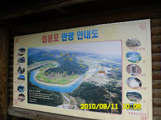
Place: BiRyongSan/HweRyongPo, Yechon, Gyeongsangbuk-do
Course: Parking Lot – JangAnSa Temple – Beacon Stand – No. 2 Observation Stage – Mt. Three River Front – Mt. Chair - Mt. JeokSeokBong – YongPo Village – Parking Lot (about 4.5 hours)
Partners: 25 AhToSan members
It was raing all over Korea in the morning. Yet 25 members came to the bus. We originally planned to climb Mt. WolAkSan in ChungBuk, but all mountains in Korean National Park were closed that day. We had to go alternative mountains.
Staff members of AhToSan asked the members for accessible mountains. One of experienced hikers, “DulMujige” suggested “Mt. BiRyongSan” in Yechon, GyongBuk province. The mountain is located near his hometown, Andong, so he knew the area quite well.

We arrived at the entrance of Mt. BiRyongSan at 10 a.m. It was a low mountain, yet well facilitated and we can hike safely even in the bad weather.

However, it was not raining that area. We started walking after taking the group picuture.
We walked on the gentle slope and soon arrived at a temple named JangAnSa Temple where there are several stone statues.


Then we came to the 2nd observation plateform from where we had good command of The NakDongGan River. The river makes beautiful S shape curve and we could see it well.


We had lunch there. There was a two story gazebo. In case of rain, we could use of the facility to shelter ourselves. But no rain. I joined the couple named “NulBo” and shared our lunch dishes. They liked my “duck meat” and I liked their pork dish.


We had another group picture here and stared trekking again. After walking up and down, we came to the river side. The water in the river was plenty due to the rain in the previous days. There was an interesting small and long bridge named “PyongPyongDari.” The plants along the trail were also plenty and beautiful

We came back to the place were we started the hike at 2:30 p.m. It was a 4 hour and half trekking and we had no rain at all.

It was not only our hiking club, AhToSan, to change the destination. There were 2 other buses near our bus. They began “tippuri” party just like us. But we had the longest party from 3 p.m. to 4:15 p.m. We enjoyed our “tippuri” party with plenty of food such as “도토리묵” or “acorn-starch jelly paste” and “더덕 막골리” or “Makgolli” wine with “deodeok mountain herb”etc.
We came back to Expo South Gate Parking Lot before 7 p.m. and I came back to my room by taxi, because it was still raining in Daejeon.
I am really happy that AhToSan never give up hiking no matter the weather is.
日時:2010年9月11日(土)全国的に雨(ただし、山行地は曇り)
登山場所:慶北・醴泉(예천イェチョン)の飛龍山(ピリョンサン비룡산)・回龍浦(フェリョンポ회룡포)
コース: 駐車場~長安寺(장안사)~狼煙台~第2展望台~三江前峰(삼강앞봉)~椅子峰(의자봉)~チョクソク峰(적석봉)~龍浦村(용포마을)~駐車場(4時間30分)
同行者:アトサン会員25名
この日は全国的に雨。大田も朝から雨で、タクシーでエキスポ南門駐車場へ。このような天候でもアトサンは登山を中止しない。しかし、予定していた忠北・月岳山(ウォルアクサン)国立公園は入山規制がかかって登山できない。
やむなく、アトサンスタッフは会員と相談して、雨天でも安全に登山できるということで、慶北・醴泉(예천イェチョン)の飛龍山(ピリョンサン비룡산)に登ることにした。提案したのは安東出身のトルムジゲ(野の虹)氏である。

駐車場に着いたのは10時。山行概念図のある登山口で記念撮影をしてから出発。

たしかに登山道は広く、よく整備されていた。真新しい石の仏像のある長安寺を経由して、第1展望台を過ぎ、第2展望台で11時半になった。


ここは展望台も広く二重構造なので雨が降り出せば雨宿りが容易だ。しかし、いまにも降り出しそうな空模様ではあったが雨は降らず、広いテラスで弁当を広げることができた。
この展望台からは洛東江が回流する部分がよく見えた。私は比較的小さな「トッチャリ(敷物)」でヌルボ夫妻と「七甲山」とともに弁当を食べた。

今回も持参した「オリゴギ(カモ肉)」は好評。しかしヌルボ夫人が料理した豚のふくらはぎを使った辛い煮物がうまかった。
ここでも団体写真を撮影後、低い峰を2,3上り下りした後、洛東江のほとりに出た。

「ピョンピョンタリ」という細い橋を横目に見て川沿いの細い道を30分ほど進むと、最後の上りがあり、そこを登ると登山開始した地点に戻った。


4時間半ほどのトレッキングで実に適切なチョイスだった。他の山岳会もバス2台別々に駐車していて、それぞれティップリをしていたが、我々のティップリが一番長く、ティップリ開始が3時で終了は4時15分だった。

まず、ウポが用意したトトリムックとトドク・マッコリ、次にメインディッシュの野菜が豊富に入ったプッチム、最後にサリキノコ・豚汁が出た。マッコリの味が良くてかなり飲んだ。
南門には7時前に着きタクシーで戻った。こんな天気でも登山ができるアトサンに感謝。
0 件のコメント:
コメントを投稿