Place: GuBongSan (264m), Seo-gu, Daejeon
Course: “BBaul Yaksuto(빠울 약수타)” (Bbaul Mineral Spring) – the 1st gazebo (GwanPungJeong) – the 2nd gazebo – the 3rd gazebo (GuBongJeong) –> back to “Yakusuto” using the same trail. (5 km, 3 hours)
Partner: Alan (USA), Tracey (Australia)
Alan proposed “Seollal” hiking at Stammtisch on Feb. 2nd. “Seollal” means Lunar New Year’s Day. This year, it happened to be on Feb. 3rd. In Korea three days starting with Lunar New Year's Eve are national holidays.
Alan called me at 10 a.m. So I went to see him in front of his institute (the back gate of KAIST) at 11 a.m.
He drove to E-mart where we picked Tracey up and headed for GuBongSan.
"GuBongSan" means “The Mountain with 9 Peaks.” There are several "GuBongSan" in Korea, but this one must be the lowest, I guess, although Daejeon city office designated the autumn view of this mountain as one of the eight most beautiful landscapes in Daejeon.
 [At the entrance of the trail, 九峰山登山路入口にて、구봉산 등산로 입수에서]
I climbed this mountain with Alan before. That time, we entered from the cemetery area. This time, we took a shorter couse from the “Yaksuto” or “Mineral Spring.”
 [We prepared for the hike at the entrance of the trail,登山路入口でハイキングの準備をした。등산로 입구에서 하이킹 준비를 했다.]
The entrance of the trail was partially frozen. So, Alan and I wore climbing irons. After walking for 10 minutes or so, we came to the wooden stairs. They seemed quite new.
 [The guide post showing the "Yaksuto" and "GuBongJeong" 薬水場と九峰亭を示す標識、약수터와 구봉정을 나타내는 표식]
Then we came to the ridge, and there was a nice gazebo with a clock on the wall. There was also a nice frame with 3 chinese letters “GwanPungJeong” the name of this gazebo.
 [The gazebo with a clock and the three letters of Kanji, 時計と「観風亭」の入った額、시계와 한자「관풍정」이 들어간 액자]
  [At the first gazebo, 第1亭子にて、관풍정에서]
“Gwan観” means to see, and “Pung風” means wind, and “Jeong亭” means gazebo. So, you can see wind from this gazebo!
We looked down a part of Deajeon. We could see a lot of high-rising apartments from there.
I had lunch while others had snacks there.
Then we enjoyed nice views while walking on the ridge toward GuBongJeong.
There was the 2nd gazebo between the 1st and the 3rd ones.
 [The 2nd gazebo, 第2亭子、두번째의 정자]
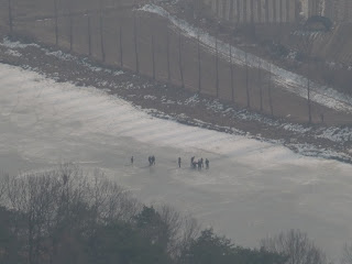
 We arrived at the 3rd gazebo (GuBongJeong) at 1:25 p.m. We could see nice view from there. We could see the Gapchon River making a big curve and the cemetery area as well. There were some visitors at the cemetery, and even on the frozen river!
 [At GuBongJeong, 九峰亭にて、구봉정에서]
We returned to the Water Place from GuBongJeong. On our way back, a middle aged trail runner spoke to Trace at the first gazepo.
He spoke to her in Korean language, first, then he called his daughter by his cellphone and handed it to Tracey. His daughter was an English teacher, therefore, she could talk with Tracey in English.
It seemed that he just wanted to let Tracey know his daughter could speak English! What a strange man. But Alan picked up the cellphone and talked with his daughter to join our regular meeting of “foreginers.”
 [Alan was talking with a daughter of the trailrunner, トレイルランナーの娘さんとケータイで会話をするアラン、토레일 러너의 따님과 휴대폰으로 대화를 나누는 앨런]
We decended the mountain with this middle aged trail-runner. But we missed the right trail to return to our car.
We had a little trouble to find the right trail. Anyhow, we back to the “Yaksuto” at 3 p.m.
 [We came back to "Yaksuto" by 3 p.m.我々は薬水場に3時に戻った。우리는 약수터에 3시에 되돌아왔다.]
 It was the first hike for Feburary, and the 9th hike for this year.
登山月日:2011年2月3日(木)[旧正月]
登山場所:九峰山(クボンサン구봉산264m)大田広域市西区
登山コース:パウル薬水場(빠울 약수텨)~第1亭子(観風亭)~第2亭子~第3亭子(九峰亭) [往復](往復約5km、3時間)
同行者:アラン(米国)、トレイシー(豪州)
前日のスタムティッシュでアランが「ソルラル・ハイキング」を提案。大田市内の九峰山に登ることにした。「ソルラル」は旧正月で今年は2月3日。韓国では旧正月を挟む両日も祝日なので3連休になる。
10時にアランから電話があり、11時にKAIST後門で待ち合わせることにした。早速弁当とコーヒーを用意してKAIST後門まで歩いた。
アランは私をピックアップしてからEマートへ向かい、トレイシーをピックアップ。三人で九峰山へ向かった。
九峰山はその名のとおり、9つの峰がある大田市内の山で、私はアランと2回登ったことがある。九峰山の紅葉は大田八景の1つに数えられている。
今回は以前と異なり、墓地へは行かず、高速道路のトンネルのわきの水場(韓国語では薬水場:「ヤクスト」と言う)に駐車して入山した。
 [↑The map of Mt. GuBongSan, and the board on which the healthy effects of the trail were written ↓, 九峰山の地図と、この登山路(黄土道)および「裸足歩き」の効用が書いてある看板구봉산의 지도와, 「황토길」과 「발지압」의 효용이 씌어져 있는 간판.]
この登山路は最近、木の階段で整備されたようで、30分ほどで亭子(チョンジャ)のある最初の峰の頂上に出た。途中、坂道の雪が凍っており、アランと私はアイゼンを装着した。
 [Alan on the wooden stairs, 木の階段のアラン、나무 계단 위에 서는 앨런]
歩き始めたのが11時半だったので、この最初の亭子で昼食をとることにした。本格的な弁当を持参したのは私だけで二人は軽いスナックだった。
 [At the first gazebo, 第1亭子にて、관풍정에서]
あとは尾根伝いに左右の展望を楽しみながら、1時間ほどのハイキングで九峰亭(クボンジョン)に到着した。
ここは若干風が当たり、涼しかったが、途中は風もなく陽が当たって汗ばむほどだった。
九峰亭からは飛龍浦のように甲川が大きく曲がる部分が見え、甲川は全面凍結していた。
 [At GuBongJeong, 九峰亭にて、구봉정에서]
この日は旧正月の連休第1日目だったせいか、墓参りの人々が見えた。また、凍結した甲川の上にいる人々も良く見えた。
 [You can see people on the Gapchon River (Please click twice),甲川の上の人々、전면결빙한 갑천 위의 사람들]
九峰亭からUターンして第1亭子へ戻るとちょうど2時だったのでここまで往復2時間。ここで1958年生というトレイルランナーのおじさんに話しかけられた。
トレイシーに向かって韓国語で話しかけ、それが通じないと携帯電話で英語の教師をしているという自分の娘へ電話してトレイシーと話をさせた。
 [The first gazebo and 観風亭と山火事監視所, 관풍정과 산불감시초소]
この峰から眼下に見えるヌリウルアパート(누리울Apt)の住民だという。面白い心理だが、娘自慢の表れなのだろうか。それとも西洋の美女トレイシーと話がしたかったのか。
 [A view frim the first gazebo, 第一亭子(観風亭)からの眺め、관풍정에서의 조망]
このトレイルランナーと一緒に下山したら、水場へ下りる道を通過してしまい、畑の中を歩く羽目になったが、無事車に戻った時間はちょうど3時だった。
 [We saw a "target" for military traing while coming down from the mountain, 下山途中で見た軍の訓練の「標的」、하산 도중, 숲 속에서 본 군훈련의 「표적」]
 これは今月初めてで、今年9回目のハイキング。e
0 件のコメント:
コメントを投稿