"From Sydney to Kamakura"
We had to delay our departure to Japan for 2 weeks, due to the infection of Covit-19.

Since the wedding of our first granddaughter, Naomi, was successfully completed on 26 February, we decided to return to Japan for the first time in three years and purchased tickets from Sydney on April 7.
Unfortunately, I got infected with the virus on 3rd April. I felt a slight headache and sour throat that day.
However, I thought I recovered on Monday because I had no symptom on the day of the test.

On April 6, we were shocked to find out the result of PCR. It was“POSITVE!”
My wife had no symptom until the day of the test. But she began to feel a mild cold symptom such as a sore throat.
When she consulted with her GP, she was prescribed "Panadol." She had no fever.

In Sydney, there are many drive-through test places where people get PCR test.
However, there is a charge for requesting a negative certificate for travel.
We used the Pathologist introduced by my GP and paid $ 150 per person.
In Sydney, it is possible to use a commercially available RAT kit, which is easier than the PCR test.
The RAT test is easy, so the next week, when I checked with RAT kit by myself, the result was negative. However, my wife was positive again.
Both were negative on the RAT test on Wednesday morning, April 11, within 48 hours of departure.
We took PCR tests, but the results were hard to come by. No results were obtained at 9 pm on Thursday, April 12, 24 hours before departure, and 3 hours later, "POSITOVE" results were informed by SNS.
Flight tickets can be changeable if we ask for, more than 24 hours before boarding, but at that point, it was too late.
A week later, I learned from word-of-mouth that an agent to issue certificate by the cost of A$ 79.
First, we had free PCR tests 74 hours before the boarding to confirm that we were "negative," then we took fee-charging PCR tests 48 hours before the boarding.
Finally, we got "negative certificate" this time. After all, two weeks later than originally planned, we left Sydney on April 21 and arrived at Haneda on April 22.
In Haneda, PCR tests are also required after arrival, and only if the result is negative, you can enter the country without quarantine.
In Sydney they use sample while rubbing the oral cavity and nasal cavity. But in Haneda, they use saliva for the sample for PCR tests.
Due to my chronic diabetes, it was hard to produce enough saliva for me. After struggling to produce saliva I gave up and went the last person of the line where people use the same method in Sydney (most children were under this category.)
We were finally released 3 hours later after our arrival, but we faced another problem with transportation to go home.
The number of direct buses from Haneda Airport to Ofuna was too small, so we had no choice but to take a taxi to our house. The charge was 14,500 yen.
"Shonandaira湘南平-Komayama高麗山" Saturday, April 30
The first hike after returning to Japan was Shonandaira, and the companion was Mr. Matsumoto, my mentor. We left our home at 9 o'clock and took Tokaido line and got off at Oiso station around 9:30.
We went walked along the railroad track and went out to the other side through the underground passage in front of Oiso Elementary School.

Immediately going up the paved road in the residential area, we came to Tamotsu Takata Park. From this area, we could see the view of Sagami Bay and Izu Oshima Island.
We entered the mountain trail from the side of the Tamotsu Takata monument.

Looking the tank of the Higashikoiso reservoir on the left along the ridge via Mt. Hajiro, we walked straight to reach Shonandaira.
Shonandaira has a driveway leading from the foot of the mountain and it can be reached by car. I've been here with my wife by car before. There is a TV tower on the way, but it is not accessible for hikers.

Shonandaira has a magnificent observatory, a restaurant, and a parking lot. We went up to the observatory there. We could see not only Sagami Bay, Izu Oshima Island and Enoshima but also Miura Peninsula on the left side, Boso Peninsula beyond the Miura Alps, and Mt. Nokogiri in Chiba Peninsula.

If you turn your eyes to the right side of Sagami Bay, you can clearly see Futagoyama and Izu Peninsula in Hakone, and on the right side of Hakone, you can clearly see the Tanzawa Mountains and Ohyama.

However, unfortunately, Mt. Fuji, which rises behind them, was covered with clouds, and we could see only a part of the middle of the mountain near the summit.
There is a slightly lower observatory on the mountain side near the TV tower, and after seeing this, we looked for a bench with a table and had an early lunch.
After lunch, we began walking the direction of the TV tower, and followed the ridge in the direction of Mt. Sengen to Mt. Koma via Mt. Happyo, I went down to Takaku Shrine via Mezaka.
I thought the atmosphere of the course was similar to Mt. Takao.
After going out to the urban area, we passed through the nostalgic “Kewaizaka” pine trees and walked parallel to the railroad tracks to return to Oiso Station.
The daily walking distance was 14.2 km, the number of steps was 21,017, and the stairs we climbed up to the 80th floor.
"Sakashita Dam, Okuma-Machi, Futaba-gun" Wednesday, May 4
I visited Tomioka-Machi, Futaba-gun, Fukushima Prefecture, where our second son's family lives, during the three consecutive holidays of Golden Week from May 3rd to 5th.
Our second son, Ryo got married in February 2016, six years ago. He and his wife have been involved in the recovery project of the Great East Japan Earthquake as a couple.
They have moved to Tomioka-Machi, Futaba-gun, where the crippled nuclear power plants of TEPCO locate close-by.
However, they have a 3-year-old daughter and a 3-month-old son, and they are busy for raising children.

My wife had a mission to help as a babysitter, but I was useless in this regard. Therefore, Mr. Matsumoto and I enjoyed hiking there.

When we arrived at Tomioka Station, our son came to pick us up and we joined a kind of ceremonial picnic called “Okuizome (お食い初め) or "beginning of eating" for their 100th day old son.
Ryo is currently working as a hotel manager in addition to volunteering for the recovery project. Ryo works at a hotel in Okuma-Machi, which is next to Tomioka-Machi.

On the 2nd day, we accompanied with him to his office, then Mr. Matsumoto and I started hiking to Sakashita Dam. My companion was Mr. Matsumoto again.
First, we looked for a convenience store to buy food and ATMs. But the convenience store near the hotel is a local convenience store and there is no ATM. we bought only lunch boxes and snacks and looked for a convenience store with an ATM on our way home.
We headed to Sakashita Dam while looking at the local map we got from Ryo. On the way, we saw the scars of the magnitude 7.4 earthquake on March 16th this year, such as collapsed gates and walls.

The flowers are beautiful with the rhododendrons and azaleas in full bloom but blossoms of cherry blossoms all gone.

The Sakashita Dam is a dam that spans the Kuma River, and when we read the explanation board that stands on the shore, we found that in addition to water and power generation, the "TEPCO water pipe" leading to the Fukushima Daiichi Nuclear Power Plant installed.

TEPCO's nuclear power plant is still being decommissioned 11 years after the Great East Japan Earthquake that occurred on March 11, 2011,the subsequent tsunami, and the melting of the reactor. Therefore, it may be used for water and electricity generation only for local use now.

“Someiyoshino” cherry trees are planted on the shore of the dam, and many people may have visited when it was in full bloom. There were no visitors other than us on this day, and we walked slowly along the quiet lakeside.

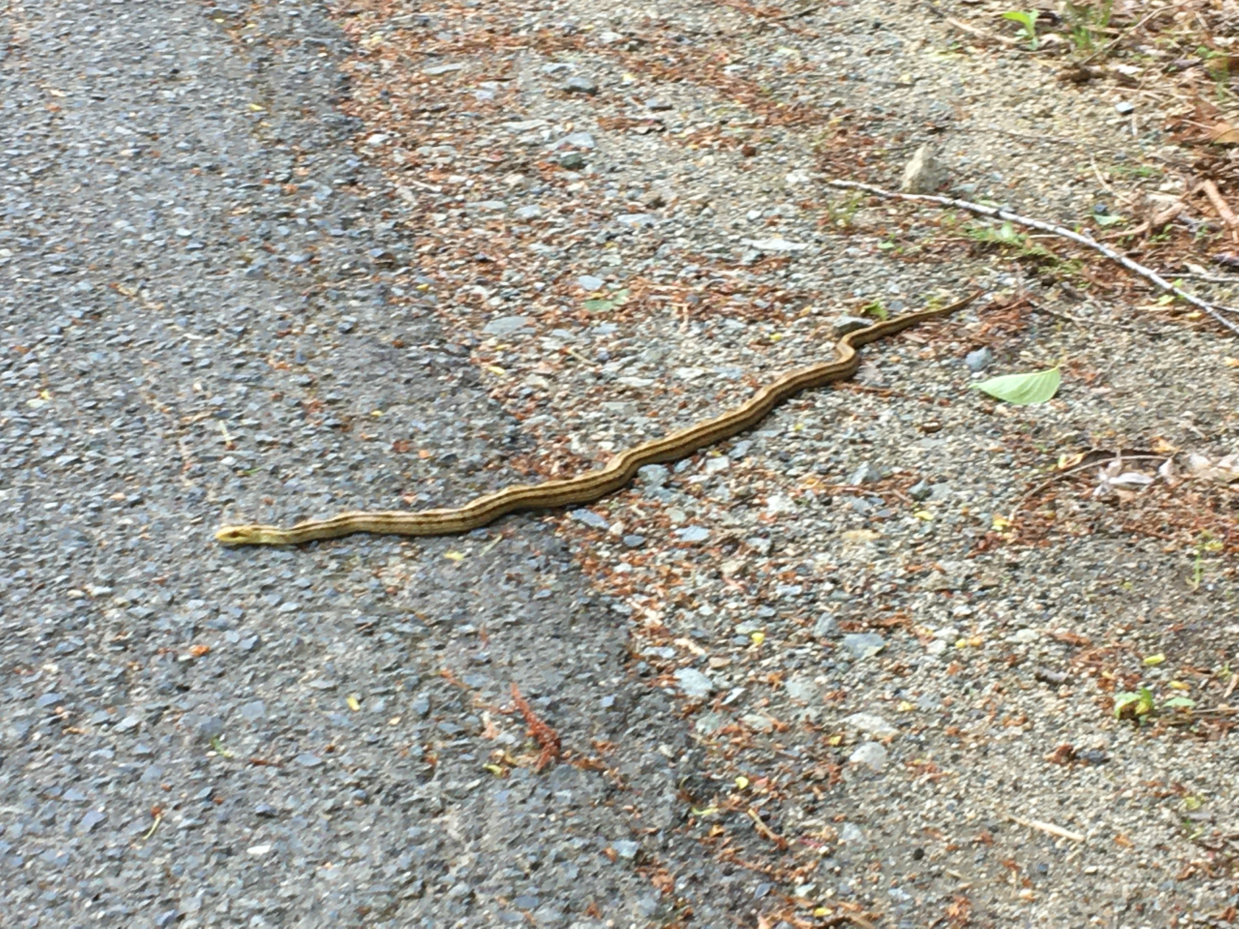
Part of the lakeside and the surrounding mountains have an exclusion zone sign, which is due to the high dose of radiation. After about an hour on the shore of the dam, there was a gazebo, where we had lunch. Along the way, there was a sign saying "Beware of ‘mamushi’ (Japanese pit vipers)", but the snake we encountered seems to be a striped snake, not the poisonous one.

In addition, there was a sign saying "Bijonakase-no-seseragi” or “Babbling Stream of Weeping Bride" at the entrance of the trail. But the entrance was closed due to high dose radiation.
After lunch, we returned the same way and headed to Hotel Okuma, where my son works. Hotel Okuma is located right next to the Okuma Town Office and the area around the Town Office was as beautiful as a well-maintained park.
Especially at this time, the moss phlox was beautiful and the wisteria flowers were in bloom, but this one is still young and it seems that it will take several years to see it in full bloom.

We stayed at Hotel Okuma on that day.
The walking distance on that day was 14.7km,
the number of steps was 23,064,
and the number of floors we climbed was only 4th floors.
----------------------------------------------------------------------------------------
鎌倉レポート第7号 「シドニーから鎌倉へ」「湘南平~高麗山」4月30日(土), 「双葉郡大熊町坂下ダム」5月4日(水)
「シドニーから鎌倉へ」
直前の検査で陽性判明。出発が2週間遅れる。
我々の初孫である直美の結婚式も無事終わったことから3年ぶりに帰国することに決め、シドニー発4月7日の航空券を購入した。
しかし、搭乗72時間前の4月5日のPCR検査の結果、陽性判定が出た。検査2日前の日曜日、私は喉の痛みを覚え、頭痛がした。だが、月曜日にはどちらも和らぎ、検査当日は症状はなかった。妻は検査当日まで無症状だった。

4月6日陽性判定が出た日から妻は軽い風邪の症状、すなわち喉の痛みが続き、GPに相談したところ「ファナドール」を処方された。熱はない。 シドニーではPCR検査ができる場所はドライブスルーが多く、無料である。ただし、旅行用の陰性証明を求める場合は有料である。我々はGPが紹介したパソロジストを利用し、一人150ドルを支払った。

また、シドニーではPCR検査よりさらに簡便な市販のRATキットによる検査が可能である。
RAT検査は簡単にできるので翌週、自分でチェックすると1週間後の火曜日、私は陰性だが、妻は陽性になった。
出発48時間以内である4月11日水曜日の朝、RAT試験をすると二人とも陰性になった。そしてPCR試験を受けたが、その結果がなかなか出なかった。
出発24時間前の4月12日木曜日の午後9時になっても結果が出ず、その3時間後に「陽性」判定がSNSで届いた。航空券は搭乗24時間以上前なら変更がきくがこの時点で無駄にしてしまった。
この一週間後、「陰性証明」をもらうためのエージェントも79ドルというところを口コミで知り、そちらを利用した。まず74時間前に無料のPCR検査を受けて「陰性」であることを確認し、次に48時間前に有料の検査を受け、今度はめでたく「陰性証明」を受け取った。

結局当初の予定より2週間遅れで、4月21日にシドニーを発ち、22日に羽田に到着した。
羽田ではさらに到着後PCR試験が義務付けられており、その結果が陰性であるばあいのみ隔離なしに入国できる。
シドニーのPCR検査は口腔内および鼻腔内をこすって検体ととるが、羽田では唾液を検体とする。私は持病の糖尿病のため、唾液が出ず、主に子供たちが対象の鼻腔内から検体を採取する列にならび、大いに苦労した。
到着3時間後にようやく解放されたが、次は自宅への移動手段の問題に直面した。
羽田空港から大船行きの直通バスは便数が少なく、到着した日は夕方まで便がない。止むを得ず自宅までタクシーを利用した。料金は14500円だった。
「湘南平~高麗山」4月30日(土)
帰国後最初のハイキングはと湘南平で同行者は松本氏。9時に自宅を出て、東海道下りホームからJRに乗車。大磯に9時半ごろ着。駅前を線路に沿って下り、大磯小学校前の地下通路を通って反対側へ出た。
すぐに住宅街の舗装道路を上り、高田(保)公園に出る。このあたりから相模湾の展望が開け、伊豆大島が良く見える。

高田保の碑の横から本格的な登山路に入り、尾根伝いに羽白山経由で東小磯配水池のタンクを左に見て、道なりに進むと3方向案内標識に出る。

ここを直進すると突き当りを左に登れば湘南平である。湘南平は麓から続く車道があり、車で来ることができる。以前、喜久子の運転で来たことがある。
途中にテレビ塔があるが、こちらは登れない。湘南平には立派な展望台があり、レストハウスや駐車場もある。ここで展望台に上った。

相模湾から伊豆大島はもちろん、左側には江の島や三浦半島、そして三浦アルプスを越えて房総半島も、鋸山らしい山容も見える。

相模湾の右側に目を転じれば、箱根の二子山や伊豆半島が良く見え、箱根の右側には丹沢山塊と大山の堂々たる姿が明確に見えた。
しかし、それらの後ろにそびえる富士山はあいにく雲がかかり、頂上近くの中腹の一部しか見えない。

テレビ塔の近くにも山側にやや低い展望台があり、こちらを見てからテーブル付きベンチを探し、早いランチをとった。
下りはテレビ塔方向へ戻り、浅間山方向の尾根伝いに八俵山(はっぴょうやま)を経て高麗山(こまやま)に至る。
さらに女坂を経由して高来神社に下った。雰囲気的には高尾山に似ているかもしれない。
市街地に出てからは、風情のある化粧坂松並木を通り、線路に並行して歩いて大磯駅に戻った。
一日の歩行距離は14.2㎞、歩数は21,017歩、階段は80階だった。
「双葉郡大熊町坂下ダム」5月4日(水)
ゴールデン・ウィークの3連休、5月3日~5日を利用して次男一家の住む福島県双葉郡富岡を訪れた。
次男は6年前の2016年2月に結婚し、夫婦で東日本大震災の復興事業に携わっている。
震災による津波で事故を起こした東電の原子力発電所がある双葉郡富岡町に移住し、生活してる。一方、3歳の長女と3カ月になる長男がいて、子育ての真っ最中でもある。

妻は子守りの手伝いというミッションがあるが、この件に関しては私は役立たずである。
したがって、長男の100日祝いの「お食い初め」に参加した以外は例によりハイキングを楽しんだ。
次男は現在、復興支援のボランティア活動の他、ホテルの従業員として働いている。息子の勤務先は富岡町の隣町である大熊町のホテルおおくまである。

この日は息子の勤務先のホテルに同行し、ここを出発点にして地元の名所?「坂下ダム」へ向かった。同行者は前回同様松本氏である。
弁当やATMを使うためコンビニを探したが、ホテル近くのコンビニは地元のコンビニでATMはない。昼食用の弁当とスナックのみ購入してATMのあるコンビニは帰路に探した。
次男から受け取った地元の地図を見ながら、坂下ダムへ向かった。途中、今年3月16日のマグニチュード7.4の地震の爪痕が崩れた塀などに残る。
花は八重桜が残っていたほかはシャクナゲやつつじが満開で美しい。

坂下ダムは熊川にかかるダムで畔に立つ説明板を読むと用水・発電の他、東京電力福島第一原子力発電所へ続く「東電導水管」が設置されている。
東電の原子力発電所は2011年3月11日に起こった東日本大震災及びその後の大津波、原子炉溶解により11年を経た現在も廃炉作業が続いている。
したがって現在は用水と電力発電のために利用されているのだろう。湖畔にはソメイヨシノが植樹されていて、満開時にはさぞ多くの人々が訪れることであろう。
この日は我々以外には訪問客はなく、静かな湖畔をゆっくりと歩いた。湖畔の一部と周囲の山は立入禁止サインがあり、線量が高いためとある。

湖畔を1時間ほど進むと東屋があり、ここで昼食をとった。
途中、「マムシに注意」のサインがあったが、我々が遭遇した蛇はどうもシマヘビらしい。

また、湖畔の道から山に入ったところに「美女泣かせのせせらぎ」という標識があったが、こちらも線量が高く、立入禁止である。

昼食後は同じ道を引き返し、息子が務めるホテルおおくまへ向かった。
ホテルおおくまは大熊町役場のすぐそばに所在し、町役場の周りは整備された公園のように美しかった。

とくにこの時期は芝桜が美しく、また、フジの花も咲いていたが、こちらはまだ若く、見ごろになるのはまだ数年かかりそうだ。この日は、ホテル大熊で宿泊した。
この日の歩行距離は14.7、歩数は23,064歩、階数は4階であった。