Mountain: HwangSeokSan (황석산1,193 m) in Geochang (거창), GyeongNam(경남) Province
Hiking Course: Geoyonjeong(거연정) → HwangSeokSan(황석산) → BukBong(북봉) → GeoMangSan(거망산) → Taejanggol(태장골)→ Mahasa Temple (마하사) → Iljumun(일주문) [About 14km、6.5 hous]
Partners: 27 AhToSan members
The number of participants was 28 including myself. I walked to the South Gate Parking Lot from my studio (about 4 km). It took me just one hour.
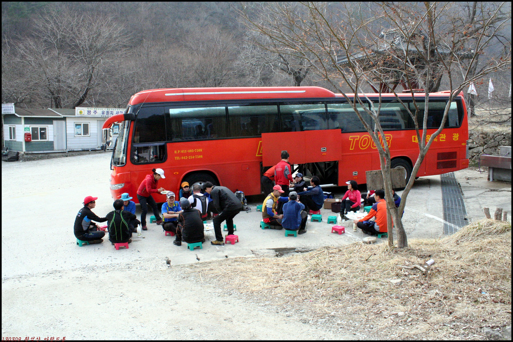
The bus left at South Gate at 7 am. I slept on the bus until Deokyusan Service Area. We had a ceremony for Mr. & Mrs. KS to celebrate their 100th regular hike attendance on the bus.

[The 100th cerebration for Mr. & Mrs. KS, KS夫妻アトサン100回参加記念式、KS 부부 아토산 100번 참가 기념식]

[Mr. & Mrs. KS making speech on the bus, KS夫妻がアトサン100回参加の所感を述べている。KS 부부가 아토산 100번 참가 소감을 말하고있다.]
We arrived at Geoyonjeong Service Area at 8:55. It was a warm day, and I took off my jacket at the beginning.

[We arrived at Geoyon SA before 9 am, 9時前に目的地に到着、9시 전에 목적지에 도착]
We walked on the paved road up to the 2nd sand-control dam through the Ujeong village for 3 km.

[A group picture before the hike, 出発前の集合写真、출발 전 단체 사진]
Near the entrance of the trail, several villagers were performing a ceremony with the head of pig. It was like “Shisanje” by hikers’ clubs. They put money (bills) into the mouth of pig. Some of AhToSan hikers greeted them and got some food from the villagers.

[At the 2nd sand-control dam, 第2砂防ダムにて、제2사방댐에서]

[A pig head "biting" money, 現金を咥えた豚の頭、현금을 물고있는 돼지 머리]


[We left the ceremony cite, 村人たちと別れて出発、마을 사람들과 헤어져 출발]
When we had “Suzuki Time” to take a short break, we ate such “gift” from the villagers, together with my fruit (stroberies and mandarin oranges.)

[At the first break "Suzuki Time"、『スズキタイム』休憩、"스즈키 타임"휴식]

After having Suzuki Time, there was a big rock called “Pipawi” or “Blood Rock.” There was an explanatory board and the name came from the Japan’s invasion in 1597.

[The explanation of "Pipawi" 『血の岩』の説明、"피바위"의 설명판]
I was as usual, the last hiker. Some old members including the president, were waiting for me and “Hangeryong” a good photographer took a picture of mine when I joined them.
We arrived at HwangSeokSan Fortress at 10:50. There are many “fortresses” in mountains in Korea. Most of them rebuilt in modern days. This must be one of them.

[At HwangSeokSan Fortress, 黄石山城にて、황석 산성에서]

[The explanation of "Hwangseoksan Fortress"『黄石山山城』の説明、"황석 산 산성 '에 대한 설명]
We walked on the “fortress” for a while, then climbed the recently facilitated wooden stairs up to near the top. They we climbed to the top of the mountain. Suddenly it was very windy. I took off my cap, and climbed up to the peak.

[Looking up the top of the mountain from the fortress, 黄石山城から黄石山頂上を見上げる、황석산성에서 황석산 정상을 올려다 보았다.]

[Near the peak of the mountain, 黄石山山頂付近にて、황석산 정상 부근에서]

[At the top of HwangSeokSan, 黄石山山頂にて、황석산 정상에서]

[From the peak, we went down using ropes, ロープを使って頂上から下る、밧줄로 정상에서 내려오고 있다.]
We went over the peak, and went down the steep slope down to the another part of the fortress. AhToSan hikers were having lunch on the fortress and I joined them.

[Eating lunch on the wall, 山城の上で昼食、산성 위에서 점심]

I ate “kimpap” and a cup-ramen quickly and started the afternoon-hike earlier than others. But soon, many hikers caught up with me and passed ahead of me.
It was a ridge hike and there were still much snow left on the trails. I put climbing irons on my boots when I came to the down slope covered with snow. At certain slope, I slipped even having irons on my boots, for about 2 meters and fell on my backside.
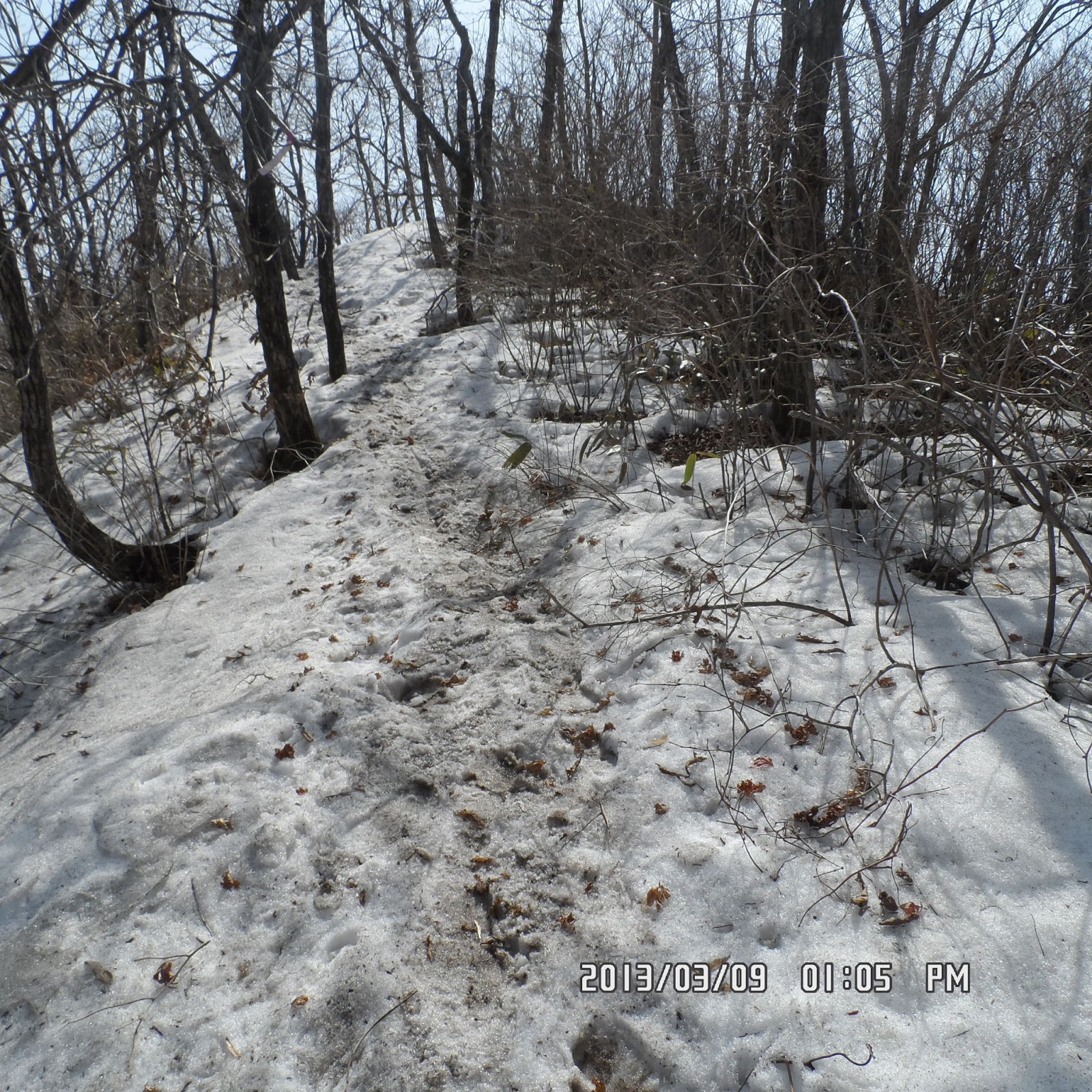
[There was much snow remained on the ridge, 稜線には多量の雪が残っていた。능선에는 많은 눈이 남아 있었다.]
When I came to the foot of GeoMangSan, “Gippenyoyu” a leader of AhToSan was waiting for slow-hikers. He told me that there was no time to climb GeoMangSan, and directed me to go downhill.

[A hiking leader was waiting for me at the foot of GeoMangSan, 挙網山の麓で山行大将の一人が待っていた、거상산 기슭에서 산행 대장이 기다리고 있었다]
I followed his advice and began descending the mountain. The trail was along the river and had to step on rocks and streams. It was a bit difficult and I walked carefully not to slip into the river.

[At Yongju Valley, 龍湫渓谷にて、용추계곡에서]

At the end of the down-trail, I mistook the direction. After about 10 minute walking on the wrong trail, I realized my mistake and went back to the original trail. Then I found some AhToSan members washing their feet, including “Gippenyoyu.”
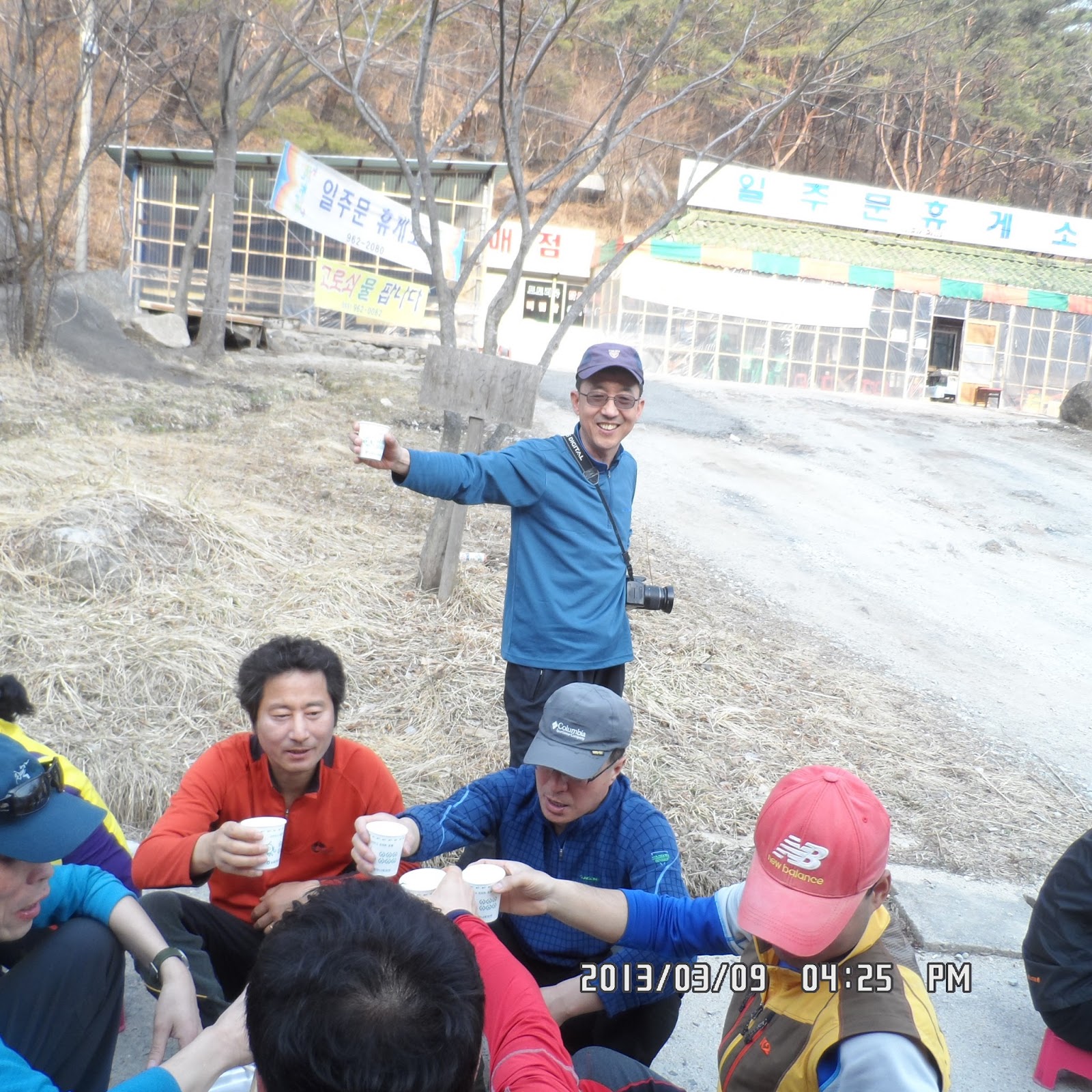
I asked him the right direction and came out to the paved road. I saw “Yongchu Waterfall” and “Yongchusa” temple, then I finally arrived at the final destination, the parking lot. It was 4 pm. So I walked for 7 hours!

[The gate of Jangsusa, 長水寺曹渓門、장수사 조계문]
[I arrived at the destination at 4 pm、午後4時にようやくアトサンのバスに到着、오후 4시에 겨우 아토산 버스에 도착]
I walked extra 4 kilometers before taking AhToSan bus. So totally I walked 18 km and 8 hours. I walked 38,000 stepts for a day!
The menu for the wrap-up party were smoked duck and vegetable salad. Mr. & Mrs. MS contributed to the party so we had better food for the party.

[A table for the wrap-up party, 打ち上げ用テーブル、뒤풀이 테이블]

[At the wrap-up party, 打ち上げにて、뒤풀이에서]

We ended our party at 5 pm and went back to the South Gate at 7 pm. I took a local bus from the South Gate to Shinseongdong.

[On the bus to go back to Daejeon, 帰りのバスの中で、돌아 오는 버스 안에서]
It was my 11th hike this year and 306th hike as AhToSan regular hike.
----------------------------------------------------------------------------------------------
分類:登山、韓国、冬山
月日:2013年3月9日(土) 晴れ
登山場所:慶南、居昌(거창)、黄石山(ファンソクサン황석산1,193 m)/挙網山(コマンサン거망산1,184 m)
コース:コヨンジョン거연정(09:00) – 黄石山頂上황석산정상(11:00) - 北峰북봉(12:00 , 昼食) - 挙網山거망산(14:00) – テジャンゴル태장골 – マハ寺마하사 – イルジュ門일주문(15:30) 約14km, 6.5時間
同行者:アトサン会員27名
参加者は今回も30名に届かなかった。今日は5時45分にワンルームを出て徒歩で南門へ向かった。ちょうど1時間で樹木園に到着した。歩数は8000歩弱。
バスは予定通り南門を7時、大田ICを7:20に出発。1時間歩いた分、疲れたせいか、休憩所までバスの中でMP3を聞きながらウトウトしてしまった。
徳裕山休憩所で休んでから、KS夫妻のアトサン100記念ケーキのキャンドル・セレモニーがあった。また、KSの所感スピーチ録音したいほどよかった。

[The 100th cerebration for Mr. & Mrs. KS, KS夫妻アトサン100回参加記念式、KS 부부 아토산 100번 참가 기념식]

[Mr. & Mrs. KS making speech on the bus, KS夫妻がアトサン100回参加の所感を述べている。KS 부부가 아토산 100 회 참가 소감을 말하고있다.]
出発地点のコヨンジョン(거연정)休憩所には9時5分前に到着。快晴で暖かく、最初から上衣は脱いで歩いた。

[We arrived at Geoyon SA before 9 am, 9時前に目的地に到着、]9시 전에 목적지에 도착
コヨンジョンからウジョン村を抜けてチョンソク(전석)砂防ダムまでの3キロは緩やかな上り坂の舗装道路で、山道に入る部分の畑の中で村人たちが豚の頭を備えて始山祭?を行っていた。

[The villagers having a ceremony, 村人たちが祭祀を行っていた、마을 사람들이 제사를 지내고있다.]
豚の口にはお札が挟まれ、果物の他、定番のトックが備えられていた。KS夫婦やテンピ、寒渓嶺らと近づき、トックやミカンをもらった。

[A pig head "biting" money, 現金を咥えた豚の頭、현금을 물고있는 돼지 머리]

[Mr. & Mrs. KS at the entrance of the trail, 登山路入口にて、등산로 입구에서]
この登山道の入り口から黄石山の山頂までは2.6kmの上り坂で、途中、1時間強歩いた10:8にチョンダウンやアランドロンに待ってもらってスズキタイム。今回はおおつぶのイチゴとミカンで1回で終わった。

[They were waiting for me, 彼らは私を待っていてくれた。그들은 나를 기다려 주었다.]

[At the first break "Suzuki Time"、『スズキタイム』休憩、"스즈키 타임"휴식]

この後、頂上まで1.9km地点には大きな岩がむき出しになって雪が残る渓谷を渡ったが、この岩は「血の岩(ピパウィ)」と呼ばれ、1597年の「慶長の役」の時、黄石山山城が陥落し、流された血によって岩が赤く染まったという言い伝えのある岩だ。

["Pipawi" or "Bloody Rock" 『血の岩』と呼ばれる岩、'피바위'라고 불리는 바위]
その後、だいぶ遅れたが、アランドロンたちが再度待っていてくれて、寒溪嶺が私の到着時の写真を撮ってくれた。
このあと、黄石山城の石垣を復元した尾根に10時50分ごろ到着した。この岩の上が頂上で、反対側の岩山にいったん登り、それからみんなのあとについて頂上の岩山に登った。

[At HwangSeokSan Fortress, 黄石山城にて、황석 산성에서]
頂上は足場が悪かったが、頂上に至るまではできたての階段がついていて容易に上がれた。この階段を戻って岩山を迂回すれば安全なコースだったようだが、そうするものはなく、すべて足場の悪い岩を越えて急坂をロープをたよりに下った。

[At the top of HwangSeokSan, 黄石山山頂にて、황석산 정상에서]

[Near the peak of the mountain, 黄石山山頂付近にて、황석산 정상 부근에서]

下り切った部分はまた復元された山城で、ここで12時となり昼食を摂った。昼食は前日購入したキムパプとカップラーメン。

[Eating lunch on the wall, 山城の上で昼食、산성 위에서 점심]
そして前回同様、早めに出発したが、途中でみんなに抜かされた。擧網山までの尾根歩きは非常に長く、残雪も多く、難儀した。
特に最後の峰のあとはアイゼンなしでは困難で、アイゼンを装着して歩いても滑って、2メートルほど尻餅をついたまま滑り落ちた。
この部分は私とともにしんがりになった白いTシャツの太めの男性といっしょに歩いた。最後に擧網山の上り口の部分にキップンヨユウが待っていて、下山路を示してくれた。

[At the foot of GeoMangSan, 挙網山の麓にて、거상산 기슭에서]
この下山路もけっこう大変で、特に渓谷に出てからは谷川の両側を行きつ戻りつ進まねばならず、簡単には歩けない。アトサンに初めて来た女性たちも、久しぶりにきた「秋の日記」も、よく歩いたものだと感心する。

[At Yongju Valley, 龍湫渓谷にて、용추계곡에서]
最後の渓谷の部分へ出る道を誤り、反対側に行ってから気づいてもどったら、最後のグループが川で足を洗っているところだった。
車道にでてからさらに30分ほど下った左手に龍秋寺および龍秋瀑布があり、そこを過ぎた場所に駐車場があった。

[The entrance of Yongchusa, 龍湫寺入口、용추사 입구]

[The gate of Jangsusa, 長水寺曹渓門、장수사 조계문]
バスに着いたのは午後4時だったからちょうど7時間歩いたことになる。歩数は3万8000歩。南門までの8000歩を引いても3万歩でずいぶん歩いたものだと感心する。
打ち上げは鴨の燻製と野菜サラダでマッコリがおいしかった。今年が最後だと言う話をアランドロンに言うと、ほかに働き口があるのではないかと言われたが、学士号さえ持たない私が働けるわけがない。
[At the wrap-up party, 打ち上げにて、뒤풀이에서]
それより来年の3月までのビザの延長ができるかどうか心配だ。打ち上げは5時に終わり、南門には7時に到着し、バスで新城洞へ戻った。
今年11目のハイキングで、アトサンのトータルでは306回目である。


