Destination (mountain): Cheonjusan, Changwon
Hiking course: Gulhyon Pass – Cheonjubong – yongjibong – Dalcheon Pass – Dalcheon Park (6 km, 4 hours)
Partner: 38 AhToSan members
It stopped raining in the morning. A little chilly, but not cold. It was a plesant morning.
Once it was full, but 6 members chancelled including Jeongbin. So total participants were 39.
The main course was only 6 km, so AhToSan prepared additional course to go farther to Sangbong. About 10 strong hikers joined this extra course.
Before arriving at the destination, we stopped twice at service areas. I found a large waterpool named Lake Jangcheok at the 2nd service area in Changnyong. It has 550, 000㎡ surrounded by cherry trees and Spiraea thunbergii (common names : baby's breath spirea, Thunberg spirea; Japanese common name : yuki-yanagi).
We arrived at Gulhyon Pass at 10:20. We took a group picture in front of the big hikig map to Guryongsan. They we began climbing the mountain opposite of Guryongsan.

[The group picture before the hike, 出発前の集合写真、출발전의 단체 사진]
The first access slope was steep. I had a hard time until I reached at the ridge. On the slope, I found several “Gakshi-bulkko”which in Japanese “Ehimeayame.”

[“Gakshi-bulkko”which in Japanese “Ehimeayame.”日本では天然記念物の「エヒメアヤメ」、일본에서는 천연 기념물인 각시붓꽃]

This flowers can be seen rather common in Korea, but very rare in Japan. Actually it is designated as a protected species.
Anyway, when we arrived at the ridge from where we could have good commands of Masan city, we took a short break and I offered my fruits to my fellow members.

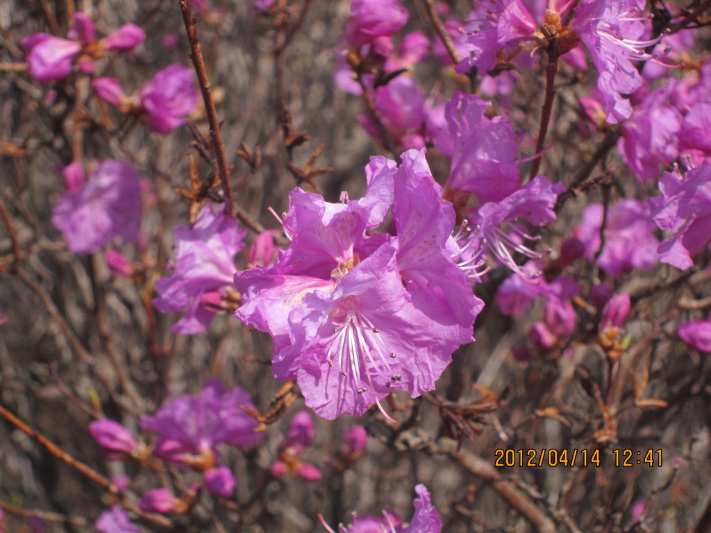
[In front of Jindallae flowers, 満開のチンダルレの花の前で、만개한 진달래 꽃 앞에서]
I could see many Jindallae flowers along the trail on the ridge. Soon, I found Alain Delon and some members having makgeolli. They also provide nice side-dishes such as tobu wrapped with wahed kimchi.

[They were having "Makgeolli Time", マッコリ休憩のマッコリとおかず、막걸리 휴식의 막걸리와 반찬]

[Jindallae flowers on the ridge trail, 稜線の登山路に咲くチンダルレ、능선의 등산로에 피는 진달래]


We could enjoy the beauty of Jindallae flowers all along the trail, and we arrived at Cheonjubong at 11:10. They had the 2nd makgeolli time after Cheonjubong.

[At the top of Cheonjubong, 天柱峰の頂上にて、천주봉 정상에서]
After Cheonjubong, we walk down to the gentle slop and we came to “Manname Gwanjan” which means “Meeting Squire.”There were many hikers there.

[I saw many craws flying in the sky, 山頂付近で韓国では珍しい多数のカラスを見た, 정상 부근에서 한국에서는 진귀한 많은 까마귀를 보았다]
We passed this crossroad of “Manname Gwanjan” and climbed the next peak with many other hikers. The leader of his hike, Hangeryong, went ahead first, and found a nice place for lunch in the woods. So we all followed him.
Most of AhToSan members had lunch together in the woods. Then we headed forward to Yongjibong (Mt. Cheonjusan), the highest peak of this hike.

[We had lunch in the woods, 林の中で昼食、숲 속에서 점심]
The trail was well facilitated with wooden plates and surrounded by Jindallae flowers. We were very happy to see so many beautiful flowers.

[A group picture on the ridge, 稜線上で中間グループの集合写真、능선에서 중간 그룹의 단체 사진]
There were many hikers beside us, esp. at the stone mark of Yongjibong. We had to take turns to take pictures there.

[At the top of Yongjibong (Mt. Cheonjusan), 龍池峰(天柱山)頂上にて、용지봉(천주산)정상에서]
From Yongjibong to the last destination of the hike was mostly easy down hill. I was in the main group and went down together.

[Flowers of corydalis tuber, エンゴサク(延胡索)の花、연호색 꽃]
Then we came to a fork point of two trails. One goes to right and the other goes to left and there was no guidepost.
Jeongjeong, a female leader said that she had seen AhToSan bus on the right side. So we followed her. She was right.
We came to Dalcheon Park with a lot of cherry blossoms were in full bloom. We could enjoy these cherry blossoms as well.

[The cherry blossoms were in full bloom at Dalcheon Park, 達川公園の桜は満開だった、달천공원 벚나무는 만개이었다]


There were some old women sitting on the side of road, selling wild vegitables. I bought “Dureup bugak” or shoots of aralia elata. I cooked them at home.

[Shoots of wild aralia elata, 野生のタラノメ、야생 두릅]

[Corydalis pallida var. tenuis,ミヤマキケマン(深山黄華鬘),현호색속 꽃]
We arrived at the bus under the bridge of highway at 14:40, so it was a four-hour hike. We had wrap-up party there until 15:30 and headed toward Daejeon.

[The wrap-up party under the highway, 高速道路の下で打ち上げパーティ、고속 도로 아래에서 뒤풀이 파티 ]

On the way, we stopped at “Upo wetland.”
Below is the description of the largest wetland in Korea by Wikipedia.
---------
Upo wetland is a complex of natural wetlands located in Changnyeong County, South Korea, near the Nakdong River. It is located in portions of Yueo-myeon, Ibang-myeon and Daehap-myeon. It derives its name from the largest of the wetlands, Upo. Other wetlands in the complex include Mokpo, Sajipo and Jjokjibeol wetlands. The complex as a whole covers 2.13 km², and is the largest inland wetland in South Korea today. It is one of eight Ramsar wetlands in the country and one of the official visiting sites for the 10th Meeting of the Conference of the Contracting Parties that was held in Changwon, Korea in October, 2008.

[The wooden steps to observatory, 展望台への木製階段、전망 대에 가는 목제계단]

[In front of the gazebo on a hill by Upo Wetland, 牛浦沼の丘の上の八角亭の前で、우포늪 언덕 위의 팔각정 앞에서]
Upo is home to numerous endangered, threatened and rare species. Based on a 1997 survey, the wetland is believed to be home to a total of 342 endangered or threatened species: 168 species of plants, 62 species of birds, 55 species of arthropods, 28 species of fish, 12 species of mammals, 7 species of reptiles, 5 species of amphibians, and 5 species of molluscs.
The most famous rare plant found here is the prickly lotus, Asin euryale. A particularly noted bird species is the Black-faced Spoonbill. Upo provides habitat to large numbers of migrant birds, including other rare species such as the White-naped Crane and Taiga Bean Goose. A notable reptile species is the Reeves turtle.

[At Upo Wetland( one of 7 wetlands protected by Ramsar Convention, 牛浦沼(ラムサール条約登録湿地)にて、우포늪(람사조약등록 습지)에서]

Most of Upo has been protected since 1997, and is now part of the Upo Ecological Park. However, agricultural and fishing activity still takes place on the wetland. A growing eco-tourism sector has developed in the country, although many local residents remain hostile to the idea of protected land. A visitor's center and observation tower have been constructed near the wetland to facilitate tourism, and in interpretive center has been established nearby.
------
We had a leisurely walk around the wetland for 40 minutes (16:10-16:50) and returned to Daejeon.
This was my 21st hike for this year and 276th hike to participate AhToSan hiking as the total.
--------------------------------------------------------------------------------------------------
登山月日:2012年4月14日(土)快晴
登山地:慶南(キョンナム경남)昌原(チャンウォン창원)の天柱山(チョンジュサン천주산640m)
登山コース:クルヒョンコゲ(굴현고개)-天柱峰(천주봉)-天柱山(龍池峰용지봉640m)-タルチョンコゲ(達川峠달천고개)-(達川渓谷–達川公園 駐車場(約6km / 4時間)
同行者:アトサン会員38名
夕べの雨は朝まですっかり止み、気温は低かったがマイナスではなく、気分良い朝を迎えた。
いったんは満席になったアトサンのバスはその後ジョンビンも含めて6人がキャンセルで39人となった。
久しぶりにポラムやソヨン及び「コヒーの香り」が参加した。また、双子の兄弟がどちらもカップルで参加した。
登山地は慶南、昌原の天柱山。コースはクルヒョン峠(굴현고개)-天柱峰-天柱山(龍池峰)-達川峠(달천고개)-(達川渓谷–達川公園駐車場の約6km / 4時間)と短かったため、上峰(サンボン상봉)[ノンバウィ(농바위)]方面から稜線を行く追加コースも準備され、こちらのコースは10人程度が行ったようだ。
往路の最後の休憩場所は慶南・昌寧で55万㎡にもなる「丈尺湖(チャンチョクホ)」があり、この周囲のユキヤナギや桜が満開で美しかった。
出発地点のクルヒョン峠には10時20分に到着。集合写真は今回の登山予定ではない九龍山登山案内図の前で撮影。車道の横の急な斜面から天柱峰に向かっての急坂を登りはじめた。

[The group picture before the hike, 出発前の集合写真、출발전의 단체 사진]

最初の30分間は急こう配の登りをひたすら登ったが、はやくも「エヒメアヤメ」をあちこちに見つけて嬉しい気分になった。

[“Gakshi-bulkko”which in Japanese “Ehimeayame.”日本では天然記念物の「エヒメアヤメ」、일본에서는 천연 기념물인 각시붓꽃]
いつも登り坂はきついが、今回もふくらはぎと脛が痛むほどだったが、登り切ると市街地を足下に見下ろす岩に出て、ここで恒例の「スズキタイム」にした。
また、岩の周囲にはチンダルレが満開。急こう配の斜面を登り切った岩の先は稜線の道で、およそ10分ほど進んだ場所でアランドロンらがマッコリタイムをしていた。

[Yellow heartsease (violet),黄色いスミレ、노란 제비꽃]
豆腐をキムチで包んだものや山菜をおかずにマッコリを1杯いただくのはいい。また、尾根道の両側にはずっとチンダルレが咲いている。また、正面に見える山腹から頂上にかけてもチンダルレの帯が見える。

[At the trail on the ridge, 稜線の登山路にて、능선의 등산로에서]


天柱峰には11:10に到着。天柱峰から10分ほど進んだ尾根道でも2回目のマッコリタイム。そしてひとしきりチンダルレの群落をたのしみつつ進むと下り坂になり、登山路が交差する「出会いの広場」に出た。
[The Jindallae were in full bloom, 満開のチンダルレ、만개한 진달래]

ここで早くも昼食を取っている小グループがあったが、七甲山が先頭グループの寒溪嶺とウォーキートーキーで連絡をとり、山頂付近に昼食に良い場所をとったというので山頂に向かって進んだ。すると林の中にたしかによい場所があり、ここで大半のメンバーが昼食にした。

[We had lunch in the woods, 林の中で昼食、숲 속에서 점심]
昼食は12:10頃終え、今日の最高峰である天柱山・龍池峰に向かった。龍池峰に至る道は木道が整備され、周囲のチンダルレも実にすばらしい。
頂上へ向かう木道の展望台でチンダルレを背景にした「コーヒーの香り」の良い写真が撮れた。龍池峰の山頂には人々がごったがえし、集合写真を撮るには順番を待たなければならないほどだった。

["Fragrance of Coffee" and Jindallae,「コーヒーの香り」とチンダルレ、커피향기님과 진달래]


[At the top of Yongjibong (Mt. Cheonjusan), 龍池峰(天柱山)頂上にて、용지봉(천주산)정상에서]
ここからの下りは尾根伝いで簡単だったが、途中で左右に分かれるポイントがあり、道標がなかったため、大勢が集まって相談した。地図も明確ではなかったが、チョンジョンが左側のふもとのバスが見えたと言い、彼女に従って左側に降りた。

[A group picture at the fork point of down trails, 下山路の分かれ道で集合写真、하산로 갈림길에서 단체 사진]
この道は正解で、桜の群落というべき場所に出たが、今思うとあれが達川公園であったようだ。桜の木の下で野生の「タラの芽」をおばさんが売っていて、一山1万ウォンは安くはないが町では買えないものだから買った。「サンチ」という山菜も3000ウォンで購入した。


[The cherry blossoms were in full bloom at Dalcheon Park, 達川公園の桜は満開だった、달천공원 벚나무는 만개이었다]


桜並木をそのまま下ると高速道路の高架の下に我々のバスは停まっていた。時間は14:20だったからちょうど4時間の予定時間通りのハイキングだった。

[The wrap-up party under the highway, 高速道路の下で打ち上げパーティ、고속 도로 아래에서 뒤풀이 파티 ]
そのまま、高架の下で打ち上げパーティ。今回のメニューはトンソクで量も過不足なく、よく食べた。15:30にはパーティを切り上げ出発。
途中、韓国最大の湿地帯である牛浦沼に立ち寄った。

[At Upo Wetland( one of 7 wetlands protected by Ramsar Convention, 牛浦沼(ラムサール条約登録湿地)にて、우포늪(람사조약등록 습지)에서]
以下はウィキペディアの記述である。
-------
牛浦沼(うぽぬま、우포늪)は大韓民国慶尚南道昌寧郡の洛東江が流れる近くにある、いくつかの湿地群の総称である。
また湿地群の中で最大の沼の名称でもあり、他に木浦(モクポ)、サジ浦、チョクチボルといった湿地も含む。
位置は遊魚面(ユオミョン)、梨房面(イバンミョン)、大合面(テハムミョン)にまたがっている。湿地は全域2.13km²に及び、これは韓国最大級の面積である。また2008年6月現在、韓国に7つあるラムサール条約登録湿地の内の一つである。
牛浦沼は非常に多くの絶滅危惧種や希少種の生息地である。1997年の調査に基づくと、合計で342種の絶滅危惧種が生息していると考えられている。(内訳は以下の通り。植物168種、鳥類62種、節足動物55種、魚類28種、哺乳類12種、爬虫類7種、軟体動物5種)。

[At Upo Wetland( one of 7 wetlands protected by Ramsar Convention, 牛浦沼(ラムサール条約登録湿地)にて、우포늪(람사조약등록 습지)에서]
ここで見られる最も希少な植物は英名prickly lotus(Asin euryale、ハスの一種)であり、特筆すべき鳥類はクロツラヘラサギである。牛浦沼はマナヅルやヒシクイを含む多くの渡り鳥の中継地・越冬地となっている。爬虫類ではクサガメを挙げることができる。
牛浦沼はその大部分が1997年以降保護されており、一部は環境公園となっている。一方で、農業や漁業と言った活動が現在も行われている。この国では近年エコツーリズムが広く行われるようになってきたが、依然多くの地元住人は「沼を保護する」という考えに反感を抱いたままである。
昌寧郡では観察者の便を考え、ビジターセンターと観察所が湿地の近くに建設された。そしてその近くには解説センターが設立された。
우포늪(牛浦-)은 경상남도 창녕군 일대에 위치한 대한민국 최대의 내륙 습지이다.
약 1억 4000만 년 전에 생성된 것으로 추정된다. 창녕군 유어·이방·대합·대지면 등 231만㎡에 걸쳐 있고, 둘레는 7.5㎞에 전체 면적은 70만여 평, 가로 2.5㎞, 세로 1.6㎞이다. 대한민국 최대의 내륙 습지로 꼽히는 이곳에는 환경부가 멸종위기종으로 지정해 보호하고 있는 가시연꽃 등 340여 종의 식물과 62종의 조류, 28종의 어류가 서식하고 있다. 일본강점기인 1933년에 천연기념물로 지정되었다. 1962년 문화재보호법이 제정되자 그 해 12월 3일 '창녕 백조 도래지'라는 이름으로 천연기념물 제15호로 지정되었다. 그러나 1973년 7월 19일 찾아드는 철새의 수가 감소한 것을 이유로 천연기념물 지정이 해지되었다. 그러나 우포늪 생물 지리적ㆍ경관적 가치를 다시 평가, 2011년 1월 13일 문화재청은 '창녕 우포늪 천연보호구역'을 국가지정 문화재인 천연기념물 제524호로 재지정했다
---
我々は16:10から16:50まで、40分ほど、牛浦沼の周囲を散歩し、展望台にのぼったりしてから帰路についた。
今回は今年21回目のハイキングで、アトサンの定期登山は276回目である。


