About pictures/当ブログ内の写真について/당 블로그내의 사진에 대해서

Most of the pictures in this blog are taken by my camera, yet some of them were downloaded from the website of the hiking club. If you click any pictures, they become the original size.

当ブログ内の写真の大部分は筆者のカメラで撮影したものですが、一部、山岳会の共有写真からダウンロードしたものを含みます。すべて、各写真をクリックすれば、元のサイズに拡大します。

당 블로그내 사진의 대부분은 필자의 카메라로 촬영한 것입니다만 일부 산악회 공유 사진으로부터 다운한 것도 포함합니다. 모두 각 사진을 클릭하면, 원래 사이즈에 확대합니다.

2010年5月24日月曜日

100521 GeumSubong, Sutongol (錦繍山、ストンコル)

May 21, 2010 (Fri)

In Korea, not only Christmas, but also the day when Buddha was born (traditionally, April 8 of Lunar calendar) is a national holiday. So, Taejonhikrs planned another hiking on May 21, after May 5th of Children’s day. I joined this hike as my 25th hike for this year.

Alan planned this hike and about 20 people joined him including 8 Americans, 7 Koreans, 2 Australians and a German and a Japanese pulas 2 kids. Our common language was English as usual.


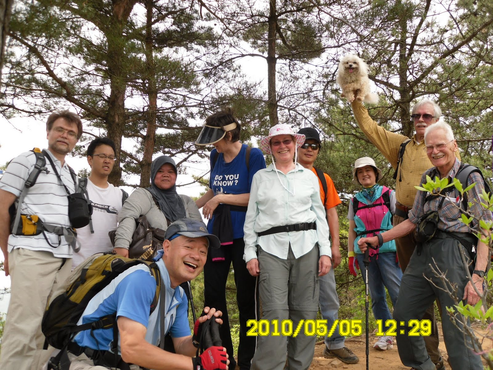
[About 20 people got together, 約20人が集まった、약20명이 모였다]

We met at KAIST main gate at 10 am, but a taxi which the newcomer, Tim the American, was caught in a traffic jam, and he came 15 minutes past 10.

The destination of our hike is Mt. Geumsusan (531m) in Sutongol. There is a spacious parking lot in Sutongol and it is also a terminal for several bus routes. A lot of Daejeon citizens enjoy hiking there on holidays. Some of Taejeonhikers came directly to the parking lot. At 11 am, all members got together, and we started after taking group pictures.

[On the way to Swegoljae, スェゴルジェへの途中、쇠골제에의 도중에서]

There are several trails available and we took an easy one along the river in Jageun Sutongol. On the way to Swegoljae, I happened to see “Chorongpem” who made 200th hike of AhToSan with me last week. He seemed to enjoy alone hiking on the same mountain.

[Alan explains the course, コースを説明するアラン、를 설명하는 앨런]

I often see aquentances while walking in the mountain in Korea. Anyway, it was a pleasant surprise for both of us.

[On the ridge、錦繍峰稜線にて、금수봉 능선에서]

The trail from Swegoljae to the top of GeumSuBong is rather steep. On the ridge, we would see good view of Mt. GyeRyongSan. It was a clear day, and I could count all peaks of GyeRyongSan from ChonWangbong to JangGunBong.

[Mt. Gyeryong, 鶏龍山の峰々、계룡산 봉우리들]

There is an octagonal gazebo on the top of GeumSuBong. We arrived at the gazebo at 12:30. When we arrived there, there were a foreinger and a Korean lady having lunch there. The foreigner was a New Zea Lander and the lady was a Korean. We all talked in English, exchanging information. We all had lunch here.

[A New Zea Lander, ニュージーランド人、뉴질랜드 사람]

After taking group pictures in front of gazebo, we began decending the mountain to Sutongol valley. Some part of the trail was really steep, but we all came down to the river safely.

[In front of the gazebo,錦繍峰頂上の亭子の前で、금수봉정상의 정자 앞에서 ]

We enjoyed washing our feet with cold water, then we walked along the river and saw Sutong Waterfall, and came back to the parking lot at 4 p.m.

[渓谷で水遊び,계곡에서 물놀이]


[After the hike, ハイキング終了後、산행 완료후]

It was a pleasant hike with fine weather and I enjoyed this hike very much.

2010年5月21日、金曜日、韓国ではクリスマスだけでなく、釈迦生誕日(陰暦4月8日、陽暦では今年は5月21日)も公休日だ。そこで5月5日の子どもの日に続いて今月2回目のTeajonhikersのハイキングに参加した。

計画・呼びかけはアラン博士で、今回も外国人が大勢集まった。(米国8人、韓国7人、オーストラリア2人、日本とドイツ各1人+子ども2人)。韓国人たちは主にToastmastersの会員たちでみな英語が達者だ。したがってわれわれの公用語は英語。

KAIST正門へ10時集合だが、初めて参加したTimが乗ったタクシーが渋滞につかまり、15分遅れた。

目的地は大田・儒城区内のストンコル(수통골)の錦繍山(クムスサン금수산531m)。ストンコルには大きな駐車場があり、市内からバスも出ているので休日には大勢の市民がハイキングを楽しむ。直接、ストンコルへ来た人々もいて、11時に全員がそろった。

本日は子どももいたので、もっとも軽いコースで、峰は錦繍山だけに登って下りることにした。

登りの道は渓流に沿って登山路がよく整備されたチャグン・ストンコルを進み、ピンゲ山[빈게산]との分岐点であるスェゴルジェ[쇠골재]へ出た。

この途中で、先週私と一緒に200回目の登山を祝ってもらったチョロンペム・アトサン前会長に会った。

このように韓国の山々で知り合いに偶然出会うことはよくあることである。

スェゴルジェから錦繍峰に登る道は意外と急で、登山に慣れていない者には厳しいが、登りきると展望が開け、鶏龍山の峰々がよく見える。

[Mt. Gyeryong, 鶏龍山の峰々、계룡산 봉우리들]

錦繍峰の頂上には、八角亭子があり、ここには12時半ごろ到着した。我々より先に休んでいた男女の内、男性はニュージーランド人で、いっしょにいた韓国人らしい女性も英語を話しており、しばらく歓談した。

八角亭子前で記念撮影後、急坂を下り、錦繍峰三分岐点[금수봉삼거리]を経て、ストンコル(수통골)渓谷に出た。登山の後、渓谷の冷たい水で足を洗うのは気持ちが良い。


[Splash at the river, 渓谷で水遊び、계곡에서 물놀이]

ここからストン滝(수통폭포)を経て出発点に戻った。約4キロで通常なら2時間のコースだが、ゆっくり休みながらのハイキングで、終わったのは4時だった。


[The Sutong Waterfall, ストン滝、수통폭포]

2010年5月19日水曜日

100515 Mt. Jiri, ChonWangBong (1915m) 智異山・天王峰

May 15 (Sat), 2010, a bit cloudy, occasionally fine.

This was the 266th regular hiking by AhToSan. The destination was Jirisan, ChonWangBong (1915m), the highest peak in the South Korean peninsula.


[Cutting cake for our 200th hike、200回目の登山を祝して、200번째의 등산을 축하해]

It happened to be the 200th hike for Chorongpem and me. So, we had “congratulation” ceremony on the bus. Chorongpem and I also bought everyone the dinner at the local restaurant after the hike.

[The 200th memorial cake, 200回登山記念ケーキ、200번째 등산 기념 케이크]

I got up at 2:30 am and prepared lunch and for hiking. I left my apartment room at 4:30 and arrived at South Gate parking lot at 4:50. Masashi and Bernardo were already there waiting for me. The bus left there at 5 a.m

There was no vacancy this time. 46 members joined this hike. We arrived at Chungsanri at the foot of the mountain before 8 a.m.

I remembered the time when I climbed the same mountain in March 2004. From Chungsanri to Chonwangbong via Bopgesa Temple, it was exactly the same course. We just returned to Chunsanri 6 years ago, but this time, we continued to walk along the ridge to JeSeokbong (1805m) and walked toward the final destination of BaekMuDong via JangToMok Shelter.

Total walking distance was 16 km, and expected walking hours were 8 hours.

As for this hike, I walked with Masashi, the Japanese astronomer who works at Korea Astronomy and Space Science Institute (KASI).

Bernardo, who also works at KASI walked with his Australian church friend, Brain all the time.

B&B walkded much faster than us, and took a time of sightseeing at Bopgesa Temple. But they were slower on the way down.

[In front of the mountain gate of BeopGyeSa Temple、法界寺の山門の前で、법계사 산문 앞에서]

When we arrived at Rotary Shelter, we heard a senior couple speaking Japanese. The couple came from Osaka to climb Mt. Jiri. They said when say saw a Korean TV drama “Hur Jun (허준, Chinese title: 醫道, also known as "The Way of Medicine: The Epic Doctor Hur Jun" and very much impressed with the scenes of Mt. Jiri. So, they came all the way from Osaka to Mt. Jiri.

[A senior couple from Osaka、大阪から来たカップル、오사카에서 온 노부부]

The man said he had lived in Daegu, but he pronounced the name of the city in old Japanese way “Daikyu.” So, I thought he would have lived in the city during Japanese colonial days (1910-1945.)

I saw them again on the top of the mountain. So they made the hike completely. How nice it is to go hiking together as a man and his wife.

I have never seen any wild animals except small ones like squirrals or insects. But they say there are wild bears in Mt. Jiri. I saw several warning signs of bear on the mountain.

When we had a short break, and had fruits which I brought for “Suzuki time,” I saw clusters of “dog tooth violet” or “fawn lilies.” When I climbed Japanese mountains, I saw several, there it was a big community of the flowers.

[The bud of "dog tooth violet", カタクリの花の蕾、얼레지 꽃의 봉오리]

[A cluster of "fawn lilies"、カタクリの群落、얼레지의 군락]

[A cluster of "fawn lilies"、カタクリの群落、얼레지의 군락]

We finally arrived at the top of Mt. ChonWangBong, it was already 12:30. Many members were already there, having lunch. Bernardo opened a bottle of wine to celebrate my 200th hike. The wine tased very goo.

It was really crowded on the top of the mountain. Geumgang took my picture with Masashi. It proves that we were on the highest point of South Korean peninsula.

[At ChonWangBong with Masashi、天王峰にて、천왕봉에서]

After lunch, I began walking with Masashi, Bernardo and Brian. It was the most leaisurous walk for this hike. The ridge from ConWangBong to JeSeokBong was a nice trail. We could see not only good view of mountains, but also beautiful flowers of jindalle, and wild cholchuk (azalea.)

When we arrived at JangTeoMok Shelter, one of the members, GaRyongBong bought cans of fresh drinks for all of us there.

The final fork to our destination there was a bit difficult to identify. Some members went to the wrong trail, but came back to the appropriate path.

Marin Boy was one of those who mistook the wrong way. But he found some beautiful flowers along the trail near the shelter. Bernardo also saw the flowers and took a picture of them. It was “gwaengnun” in Korean which means “cat’s eye.” I found the Japanese name for the flower later. It’s “Nekonome-sou” which also means “cat’s eye.” The name comes from the shape of its fruit.

["Cat's Eye" ネコノメソウの花、괭이눈(괭이는‘고양이 ’의 준말)]

It took much time from the shelter to the final destination of this hike. Masashi and I arrived at Baekmu Restaurant at almost 5 pm. Bernardo and Brian had arrived even later.

All AhToSan members congratulated me and Chorongpem. Many of them came to me for cheers with AhToSan wine named “pine leave wine.” The party ended at 5:50 and we came back to the Expo South Gate parking lot at 8 pm.

[George eats the 200th cake、200回記念ケーキを食べる、200회 기념 케이크를 먹는다]

5月15日(土)、うす曇り、時々晴れ。

アトサン定期登山第266回、目的地:韓国の名山中の名山「智異山・天王峰(1915m)」

私と、チョロンペン前会長が期せずして同時に200回目のアトサン定期登山。これを祝して、バスの中で表彰式があり、また登山後のティップリは現地の食堂で大々的に行った。

[Awarding ceremony, I got 200,000 won coupon! バスの中で表彰式、버스 안에서 표창식]

この日は2時半に起床。飯を炊いて弁当準備。ワンルームは4時20分に出発。南門には50分に到着。すでにベルナルドとマサシは到着していた。

今回は完全に満車で46人が参加。

[46 members all together, 46人で満車、46명으로 만차]

登山出発地の中山里(チュンサンリ)には8時前に到着。ここから天王峰までは6年前と同じコースで、法界寺を経由して4時間の登りだ。

ブライアンはお洒落な鍔広帽子。私も鍔広帽子とサングラスを用意した。ジャンバーを忘れ、山頂では寒い思いをするかと思ったが、幸いにもさほど寒くなく、風もおだやかだった。

前回(2006/3)のコースは中山里~法界寺~天王峰を往復する単純なものだったが、今回のコース:中山里(중산리)-法界寺(법계사)-天王峰(천왕봉)~帝釈峰(제석봉1805)-山荘街待避所(장터목대피소)-白武洞(백무동)(約15.9km)という智異山縦走コースだった。

今回の相棒は天文学者のマサシで我々は常に最後尾の少し前を歩いた。

B&Bコンビは前週の鶏龍山同様、登りは先頭グループといっしょで、法界寺の見学もするほどだったが、下りは我々の次というペースだった。

ちょうど8時に出発して見覚えのあるロータリー避難小屋に10時到着。法界寺は、今回は山門前で写真を撮るだけにして先に進んだ。

ロータリー付近で日本語を話している老カップルを追い越した。彼らは韓流ドラマ『ホジョン』をみて薬草のメッカ智異山にあこがれ、わざわざ大阪から来たと言う。

御主人は「ダイキュウ(大邱)」に3年住んだことがあるというからきっと戦前派あるいは「日帝強占時代」に韓国に住んでいたのかも知れない。

智異山は月の輪熊が生息する唯一の山で、「クマ出現、注意」看板があった。また、スズキタイムでトマトとブドウを出した時、近くの林の中にカタクリの群落を見つけた。カタクリの花はなかなかユニークで美しい。

法界寺を過ぎた11時ごろ、この寺を見学した先頭グループにまた追い越された。BBコンビとは次は天王峰山頂で再会した。

見覚えのある最後のアプローチを過ぎて天王峰に着いたのは12時30分だった。

智異山・山王峰1915mの石標付近はたいへんな混みようで写真撮影が難しい。辛うじてマサシといっしょに金剛氏に撮影してもらった。

石標の下の平らな部分で昼食。ベルナルドが私の200回登山を祝してワインを開けてくれた。

[Bernardo opened wine for me、ベルナルドがワインを開けた。벨날도가 와인을 열었다]

天王峰から帝釈峰を経由してチャントモク退避所へ行く稜線は、景観も美しく、チンダルレの花もきれいで、もっとも気持ちのよいハイキングコースだった。

[Jindalle flowers on the ridge,稜線に咲いていたチンダルレ、능선에 피어 있었던 진달래]

退避所では佳龍峰がそこにいた全員に清涼飲料水をおごってくれた。

ここから最終ゴールの白武洞へ行く道はトイレの横を通る、わかりにくい部分で、実際、ヨロやパダサナイなど間違えた会員もいたようだ。

トイレを過ぎた道端に変わった黄色い花が多数咲いていた。後で調べると「クェンギヌン괭이눈」という珍しい花で、日本語では「ネコノメソウ」と言うらしい。パダサナイとベルナルドがこの珍しい花の写真を撮った。

["Cat's eye", ネコノメソウ、괭이눈]

退避所には午後2時に着いたが、ここからの下りが長かった。最後の渓流に着いたのは午後4時半。そしてティップリ場所の白武山荘に着いたのは5時だった。

すでに大部分の会員が料理(タクトリタン)を食べ始めていた。ベルナルドとブライアンが遅れて到着。


{Spicy Chicken Soup, とても辛いタクトリタン、매우 매운 닭도리탕]

最後に佳龍峰や金剛などが到着して全員そろったが、その前に緑蛇会長が200回記念スピーチ。続いて私も感謝のスピーチ。多くの人々が私にアトサン公式酒の「松葉酒」を注いでくれた。

ティップリは5時50分に終わった。帰路は意外に早く、8時前に南門へ戻った。

2010年5月18日火曜日

100508 GyeRyongSan (鶏龍山), AhToSan Irregular Hike

May 8 (Saturaday) 2010, fine

Irregular hike by “AhToSan”
Destination: GyeRyongSan
Course: Cheonjanggol – Nammetap – SamBulBong – Jayong Seongreung – Eunseong Waterfall –Donghaksa Temple (12 km – 6 hour hike)

May 8th is “Parents’ Day.” Many Koreans visit their parents on May 8th every year. So AhToSan planned no regular hike. In stead, they planned irregular hiking to Mt. GyeRyong.

The course was exactly the same as my alone-hiking on April 30. So when people gathered at 9 a.m., I explained the course using the big map in front of the restaurant.

Total number of participants were 20 including 3 foreigners (Bernardo, the Mexcian, Brian, the Australian, and myself.)

[About 20 participants、約20名が参加、약20명이 참가]

We began climbing the mountain at 9:15. The trail at Chonjanggol is gentle and broad. It is easy to walk.

We arrived at “NanMeTap” at 10:40. We saw a “makgeoli막걸리” peddler at the fork before SamBulBong. The old lady was selling a bowl of Korean unrefined wine by 3000 won.

[The makgeol peddler and her customer, マッコリ売りのおばあさんと客、막걸리 판매 할머니와 손님]

It was only 2000 won when I saw at SamBulBong last time. So, I thought it was expensive. One of my AhToSan friends bought the bowl of wine for me. I shared it with him by half, and it tasted good.

We took group pictures on the peak of SamBulBong. The ridge between SamBulBong and GwanEumBong was called JayonSeongreun (Natural Castle Wall). This part of the trail is most exciting and beautiful. I saw many pain trees on the rocks, and Jindalle was in full bloom.

[Gruop picture at SamBulBong, 三佛峰でグループ写真、삼불봉에서 단체사진]

[Lunch on the ridge, 稜線の途中で昼食능선 도중에 점심]

The peak of GwanEumBong is too rocky to use tripod. So, it was difficult for me to take a self-portrait. With my hiking friends, it was easy for me to take one.

[Top of GwanEumBong、観音峰山頂、관음볼정산]

The trail from GwanEumBong to Donghaksa Temple via Eunseong Waterfall, it took another 2 hours.

We returned the entrance of the trail at 3 p.m. Then we had “Tippuri” or after-the-hike party at a restaurant called “PaekEunJang.”

We had “totorimuk” or acorn-starch jelly paste and “sea-food pajeon” and makgeoli and enjoyed eating, drinking and talking for one hour.

["Totorimuk" or acorn-starch jelly paste, トトリムク(ドングリの澱粉で作った寒天状の食べ物、도토리묵]

To my surprise, one of AhToSan members whose nice name is “Marin Boy” paid the whole price for all of us.

Actually this is not unusual for Korean people. I often experienced this kind of practice several times before. But it is impossible to follow suit for me, because my income is too small now.

Anyway, we all thanked Marin Boy for this treatment and finished the party at 4 p.m.

2010年5月8日(土)快晴 アトサンの不定期登山、目的地:鶏龍山
コース:チョンジャンゴル(천장골) – 男妹塔(ナンメタプ:남매탑) – 三佛峰(サンブルボン삼불봉) – 自然城稜(チャヨンソンルン자연성릉) - 観音峰(관음봉) – 隠仙瀑布(ウンソンポクポ은선폭포) - 東鶴寺(トンハクサ동학사) – 駐車場(12km、6時間)

5月8日は韓国では「オボイナル」。両親の日である。韓国では母の日と父の日が別々にあるのではなく、同じ日に「両親の日」として決められている。このため、定期登山はなく、都合のつく者だけが集まって大田近郊の鶏龍山を登山することになった。それも私が先月4月30日に登ったコースとまったく同じコースだ。

参加者は意外と多く、20名になった。このうち外国人はメキシコ人Bとその知人でオーストラリアのブライアン、そして私の3人だった。

登山を開始する前に、登山口にある大きな地図を利用して私がコースの説明をし、コンジャ氏が補足説明をした。


[I explained the course, 私がコースを説明、내가 코스를 설명]

9時集合で、9時15分には登山開始。広くてゆるやかなチョンジャンゴルの登山路は歩きやすくて快適だ。男妹塔には10時40分に到着した。

[Group picture at NamMeTap、男妹塔前でグループ写真、남매탑앞에서 단체사진]

男妹塔から三佛峰までの登山路は急だが、甲寺への別れ道で、地元のハルモニ(おばあさん)が自家製のマッコリ(どぶろく)を1杯3000ウォンで売っていた。

前回、三佛峰で売っていた無人の「頂上酒」は2000ウォンだったからかなり高い。一緒に歩いていたニックネーム「品質管理」氏が私に1杯おごってくれた。この一杯は非常に量が多く、「品質管理」氏と半分ずつ飲んだ。

今回、三佛峰には無人の「頂上酒」は置いてなかった。今回も快晴で、三佛峰で記念撮影をした。

[Gruop picture at SamBulBong, 三佛峰でグループ写真、삼불봉에서 단체사진]

三佛峰から観音峰までの尾根はチャヨンソンルン(自然城稜)と呼ばれ、城壁のようにそそり立っている。この部分は展望も良いし、岩の上に生えている松の木も立派で、チンダルレもちょうど見ごろだった。

[The view from the ridge、稜線からの風景、능선으로부터의 풍경]

我々は稜線の途中で少し早目の昼食をとった。

[Lunch on the ridge, 稜線の途中で昼食능선 도중에 점심 ]

観音峰では三脚が使えないため、単独登山の時は写真が撮れないが、このように大勢の時には他人に撮ってもらえるのがいい。

[Top of GwanEumBong、観音峰山頂、관음볼정산]

観音峰からの下りは石の階段で、いつ来てもかなりきつい。

東鶴寺は「お釈迦様の来られた日(5/21)」に向けての飾り付けが綺麗だ。また、庭に咲く花も美しい。

[Lantran decoration at the temple, 東鶴寺のぼんぼり、동학사의 등롱]

[Bleeding Heart, ケマンソウの花、금강화]

3時には出発点に戻ったが、今回は「白雲荘」という食堂に入って、トトリムク(도토리묵どんぐりの澱粉を寒天状にした食べ物)やヘムルパジョン(해물파전イカがはいったお好み焼き)を食べ、マッコリを飲んだ。

[Pajeon, イカ入りパジョン、해물파전]

このティップリに参加した全員が自己紹介をして1時間ほど歓談した。おどろいたことに、ここの費用は、ニックネーム「マリンボーイ」が一人でまとめて支払ってくれた。マリンボーイ様に感謝。

[After the hike party at PaekEunJang, 白雲荘にてティップリ、백은장에서 뒷풀이]

2010年5月16日日曜日

100505 YangSonSan(297m), ChungBuk 忠北・養性山

May 5 (Wed) 2010 Fine

Destination: YangSeongSan (297m), ChungBuk Province)

Course: Moonwi Culture Vellage Parking Lot – Youth Training Center – Eagle Rock - Two-story octagonal gazebo called “PalGakJeongJa” – Two-way Fork – ChungBong (YangSeongSan) – Parking Lot.

I joined the Teajeonhikers’ hiking planned by Alan. We met at the main gate of KAIST at 10 am.

On my way to KAIST main gate, I passed by the colony of herons on the campus. There must be more than a hundred herons make their nests here and hunt fish at Gapchon River nearby.

[A colony of herons at the campus of KAIST、KAISTキャンパス内のシラサギのコロニー、KAIST캠퍼스내 백로의 콜로니]

To my surprise, I saw Juli who established the Teajeonhikers 8 years ago and left Korea 6 years ago. I could not recognize her at first, but she remembered me.

Just like Gyeryongbong whom I met at AhToSan hiking 4 years ago, and I could not remember him at the hiking last week.

Other members beside July were; Alan, Ken the German, Bigor the Russian and his 3 small kids, GF the Ameridan and his pet, PiPi, T from Australia, Ai from Indonesia, Dr. Chen from China, Dr. Yoon the Korean and his elementary school kid, and one more Korea, total 12 adults and 4 kids and one dog.

[12 adults, 4 kids and a dog、大人12人、子供4人、犬一匹、어른 12명, 어린이 4명, 강아지 한마리]

We left KAIST at 10:15 by 4 cars. We arrived at the parking lot of Mooni Cultural Vellage at 11:05. We began hiking at 11:25.

The course is a bit different from last time when I came here with AhToSan last time. First, we walked to the Youth Training Center, then we climbed toward “Dok-suri-pwawi” or “Eagl Rock .”

[CheongWon Youth Traning Center、清原青少年修練院、청원청소년수련원]

To my surprise, Ken climbed the rock. I dare not try climbing, because it seemed difficult to get down from the rock.
[Ken climbed on the Eagle Rock、ケンが鷲岩に登る、켄이 독수리바위에 오른다]

The twin boys asked me to use my sticks, but I told them that they were not for kids. The sticks are inevitable for me to walk on the mountains to keep balance.

Hiking is a very popular past time for many Koreans. So it is well developed including the related businesses. One of such business is selling foods/drinks.

I saw ice-candy seller on one of the peaks at the mountain. The baby kid of Vigo, Sarsha, asked one of “adult hikers.” He got what he asked for, and enjoyed it happily.

There were beautiful flowers such as “San chol-chuk” or wild azalea and chindalle along the ridge.

We arrived at the top of 378 hights called “SangBong" where a two-story octagonal gazebo at around 12:30.

[The 2-story octagonal gazebo、二階建ての八角亭子、이층구조의 팔각정자]

There were many people at the gazebo, and we arrived there one by one, according to our hiking pace. So we had lunch there separatedly on the 1st floor and 2nd floor.

I had lunch with Dr. Chen, Ai from Indonesia, Alan, Vigor, and Dr. Yoon. Others had lunch upstairs.

It was really a good weather. We took nice pictures there with the scene of Lake DaeChongHo.

[You can see DaeChong Dam,後ろに大青ダムが見える、뒤에 대청댐이 보인다]

We walked down toward YangSongSan and arrived at the two-way fork. One leads to the top of YangSongSan (ChungBong 297m) and the other way to the parking lot.

[A "Tea-house" at the 2-way fork、分かれ道の「茶屋」、갈림길의 매점]

It was only I who climbed ChungBong. All others went down to the parking lot directly.

It took us nearly 4 hours for 4 km hiking. But it was an easy hike and we could enjoy talking and seeing the beautiful nature.

2010年5月5日(水)快晴、

目的地:忠北(충북チュンプク)・清原(청원チョンウォン)・養性山(양성산ヤンソンサン297m)

ハイキングコース:文義文化材団地(公園)駐車場문의문화재단지주차장~青少年修練館~鷲岩
(독수리바위トクスリパウィ)~八角亭子[378m高地/上峰(상봉)]~養性山(中峰)別れ道~中峰(상봉)~駐車場

久しぶりにテジョンハイカーのハイキングに参加。ワンルームからKAIST正門へ徒歩で行く。

KAIST構内にはシラサギのかなり大規模なコロニーがある。シラサギたちはここをねぐらにしてすぐ近くの一級河川の甲川(カプチョン)などから餌をとっているようだ。

[A colony of herons at the campus of KAIST、KAISTキャンパス内のシラサギのコロニー、KAIST캠퍼스내 백로의 콜로니]

おどろいたことにテジョンハイカー創設者のジュリと再会した。自分は人の顔の認識能力が落ちて来たのかもしれない。アトサンで4年前にあった「佳蓮峰(カリョンボン)」の場合と同様、ジュリもすっかり忘れていたが、彼女は私を覚えていた。

メンバーは、ジュリのほか、このハイキングの企画者のアラン、ドイツ人のケン、ロシア人ビゴーと息子たち3人、アメリカ人のGFとその愛犬「ピピ」、オーストラリア人のTとその友人で韓国人の「ミッシェル」、インドネシア人の留学生アイ、アランの同僚の中国人の陳(ジン)さん、同じくアランの同僚の尹(ユン)さんとその息子ユン・ドンヒョンともう一人の韓国人の同僚の大人12人、子ども4人、犬1匹だった。

KAIST出発は10:15。文義(ムニ)文化村の駐車場には11:05に到着。GFが下痢のためトイレからなかなか出てこず、登山開始は11:25になった。

コースは以前のアトサンと異なり、青少年修練館経由で稜線に登った。ビゴーの双子の息子が私の杖をねだったが、「これは子どものためのものではない」と断った。アイは最初から遅れがち。また、体調の悪いGFが常に最後尾だった。1時間ほどゆっくり登ると鷲岩(トクスリ・パウィ)に出た。驚いたことにケンがこの上に登った。

[The Eagle Rock & Pipi and Sasha、鷲岩とピピとサーシャ、독수리바위와 비비와 사샤]

鷲岩を過ぎた場所で記念撮影後、途中の高台では「アイスケーキ」屋が「キャンディ」を売っていて、ビゴーの3男サーシャがユン氏にねだって1本せしめた。

[A group picture on the ridge、尾根で記念撮影、산등성이에서 기념 촬영]

[An Ice-candy peddler on the peak, 山頂のアイスキャンデー屋、정상 아이스 캔디(ice candy)장수]

この付近から尾根伝いにはチンダルレやサンチョルチュクの花が見事だった。この後の急坂を登ると八閣亭子(gazebo)のある378m高地(上峰상봉)に到達した。ここでメンバーは1、2階に分散して昼食をとった。

私とアランとユン氏、陳氏、およびアイは1Fで、他は2Fで個別に食べた。アイが持参したインドネシア料理のおかずを味見した。辛みのきいた牛肉料理だった。

[A lunchbox of the Indonesian student, インドネシアの学生の弁当、인도네시아 학생의 도시락]

ここでは到着時間がバラバラなため小一時間ほど休憩することになった。天気が良く、大清ダムがよく見えた。378m高地からやや急な坂を下りると養性山(ヤンソンサン)の「チュンボン(中峰:297m)」へ行く道と駐車場へ下る道の別れ道になり、ここには茶店がある。

この店の主人のアジュンマがパクセ(シジュウガラ)に餌をやっていた。子どもたちがベンチの上に土足で上がるたびに彼女は韓国語で叱っていた。

ここから私を除く全員は駐車場へ下り、私は中峰経由で駐車場に下りた。ハイキングは午後3時に終了。ユン氏の車で、陳さんとアランと私は、KAISTへ急いだ。モリファ前の信号で降ろしてもらった。よいハイキングだった。