[At the Daegyon Sato, テギョンサトにて、대견사터에서]
May 1st, 2010 (Sat) fine.
Destination: Biseulsan (1083m) in Daegu. I climbed this mountain with AhToSan people in April 29, 2006. It was a foggy weather, but Jindalle (Korean azalea) was in full bloom, so it was really fantastic view. This time, it was a fine weather, but since we had cold weather in April, the flowers on Biseulsan were still in buds and not blooming at all. What a shame!

[AhToSan slogan, "Let's go hiking on Saturday!" 出発前の気合い、「ああ土曜日だ。山へ行こう!」출발전의 구호, "아!토요일은 산에 가자!"]
There were 38 hikers including 3 foreigners (1 Mexcian and 2 Japanese).

[In front of the Yugasa Temple, 瑜伽寺の山門前で、유가사 산문앞에서]
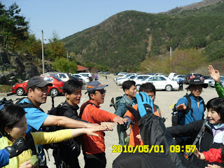
The couse was same as before. We arrived at Yugasa temple at 9:55. After taking a group picture at 10 am, we began hiking.

[Cherry blossoms near the temple, 瑜伽寺付近の山桜、유가사 부근의 산벚나무]
After walking toward ridges, we took “Suzuki-time” when I provide fruits such as grape tomato, Chinese orange called “Kinkan” and imported grapes from Chille.
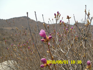
We arrived at the ridge after walking upward for 70 minutes. The ridges are in the altitude of 1000 meters. There are many jindalle trees, but flowers were not blooming.

[The flowers were not blooming yet, チンダルレはまだつぼみのまま、진달래는 아직 봉오리인채로]
We arrived at the highest peak of Biseulsan (1083m) called “DaeGyonBong” at 11:45. We had lunch at a flat space on the ridge.

[At the peok of the mountain、琵瑟山山頂にて、비슬산 대경봉에서]
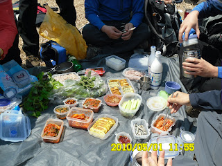
Korean people prepare a lot of vegitable for lunch. They wrap rice with vegitable and eat it. It tastes good.

[AhToSan lunch, アトサンの昼飯、아토산 점심]
After having lunch, we continued walking among the bush of jindalle toward 1034-Bong. I noticed a unique white building on the ridge. I had no idea what it was, but B and M told me it was a radio observatory since they are expert of astronomy. Both of them work at Korea Astronomy and Space Science Institute (KASI).

[The radio observatory, 電波天文台、전파천문대]
From “DaeGyonSaTo” to the last part of the hike, Sojaesa Temple was the most difficult part of this hike. It was almost “cliff” we had to go down carefully, but it was fun.

[The most difficult part of the cliff, 今日最大の難所の「崖」下り、오늘 최대의 험한 곳의 「벼랑」하행]
We could also see the block streams which were formed during the last part of ice age (10,000 to 100,000 years ago.) They say Biseulsan Block Streams are the largest ones in Korea.

[Biseulsan Block Stream, 琵瑟山岩塊流、비슬산암괴류]
When we landed on the paved road, it was a part of leisure park which non-hikers can enjoy. There was a big picture panel on which pictures of azalea are printed. It was a nice spot to take a picture, so many AhToSan hikers took pictures of themselves in front of the panel.

[In front of the panel, チンダルレの写真のパネルの前で、진달레 사진 패널 앞에서]
The menu of after-the-hike party were trotters and “pine-leave” wine which is one of my favorite wines in Korea. Unfortunately for B, the Mexcican, he does not like “trotters,” so he did not touch any of them and went back to the bus seat alone.

[A toast by the president, アトサン会長による乾杯、아토산 회장님에 의한 건배]
This is my 21st hike for this year and my 199th hike in total with AhToSan hikers.
2010年5月1日、土曜、快晴
目的地:大邱・琵瑟山(1083m)。この山は2006年4月29日にアトサンといっしょに登ったことがある。このときは霧が深くたちこめていたがチンダルレが満開で幻想的だった。今回は天候に恵まれたが、先月、低温の日が続いたため、高原のチンダルレの群落の花がまだ蕾のままで残念だった。
参加者は38名で、外国人は日本人のMとメキシコ人のBと私の3人。
コースは前回とまったく同じで、瑜伽寺(ユガサ)駐車場には9時55分到着。ちょうど10時に記念撮影をしてから出発。稜線にでるまではつらい登りが続くが、45分ほど進んだ後、ミニトマトとキンカンとブドウの3点セットによる「スズキタイム」の休憩。出発後約70分の登りで、岩の露出した稜線に出た。
稜線に出れば進む足も速まる。11:45に山頂の「テギョン峰(1083m)」に着いた。我々はテギョン峰を過ぎた開けた場所で昼食をとった。

[DaeGyongBoong, テギョン峰、대견봉]
いつも感じることだが、アトサンの仲間の昼食は野菜が豊富だ。特にこの時期は山菜を多く持参し、ご飯をくるんで食べる。

[After lunch, 昼食後、점심후]
昼食後、チンダルレの群落を歩いて1034峰を経由し、テギョンサトへ進んだが、チンダルレがみな蕾のままであったのが惜しかった。
テギョンサトへ進む道の尾根伝いの左側には特異な形の電波天文台がある。実は私にはなんの建物か分からなかったのだがMやBは天文研究院に勤める専門家なので、すぐそれと分かったようだ。

[The radio observatory, 電波天文台、전파천문대]
テギョンサトから最終点の「消災寺(ソジェサ)」駐車場へ至る道への下りは、前回とは異なるルートのようだった。ほとんど崖のような急こう配の道を注意深く下りた。途中には1万年から10万年前の氷河時代にできたという岩塊流が見えた。

[The block stream, 岩塊流、암괴류]

[Sojaesa Temple Gate, 消災寺(ソジェサ)山門、소재사의 문]
舗装された道路に出ると、そこは公園のようで、観光客が楽しめるような施設があった。
その中に、琵瑟山頂上付近のチンダルレが満開になっている写真が大型パネルに印刷され、その前で写真撮影ができる場所があった。我々もそのチンダルレの写真の前で記念撮影をした。

[The panel on which the flowers were in full bloom, 満開のチンダルレの花のパネル、만개한 진달래꽃 패널]

[The poem of "Jindalle Flowers" by Kim Sowol, the poet, 詩人・金素月の「チンダルレの花」の詩、시인,김소월의"진달래 꽃"]
今回のティップリはチョッパルとよばれるトンソクと私の好きな松葉酒だったが、Bはトンソクが苦手で、まったく手をつけなかった。

[Trotters, トンソク(豚足)、적발]
この登山は私にとって今年21回目の登山であり、アトサン通算199回目。次回はいよいよ200回目だ。
0 件のコメント:
コメントを投稿