KR (Kamakura Report) #3 “Oze National Park: Mt. Hiuchi (燧ヶ岳)and Mt. Shibutsu(至仏山)”
Typhoon Faxai (No.15) hit Kanto area Sep. 8-9 and some of my guide helper works were cancelled because of the typhoon. Yet I worked 24 missions in September.
My wife flew in Kamakura from Sydney on Sep. 13 and she joined me enjoining lives in Japan now.
As for my hobby life; climbing mountains, I went to Oze National Park (9/3 – 5) and North Yatsugatake Mountains (9/25 – 26) in September.
Here, I will report on hiking in Oze National Park(尾瀬国立公園.)
Just like my last hike in Mt. Okudainichi in Toyama Prefecture, it began with the bad weather.
I took the night bus on Sep. 3rd. There was thunder and heavy rain in Kanto area that day.
There was cloud-to-ground discharge in Yokohama, so I had difficulties to access Shinjuku Bus Terminal that evening.
I could manage to arrive on time of the night bus departure (22:20.) There were a few passengers, yet the bus arrived at Oshimizu (大清水) next morning on time.
[The 1st day in Oze: Mt. Hiuchi (燧ヶ岳2356m) 9/4]
The bus arrived at Oshimizu (大清水) at 3:45 a.m. I had early breakfast and began walking at 4 a.m.
Shuttle buses go to Ichinose (一ノ瀬), but of course, there was no bus service before 7 am. Fortunately it was not raining, and I walked for 90 minutes with head light.
[Shuttle Bus Stop at Ichinose, 一ノ瀬シャトルバス停、이치노세 셔틀버스 정류장]
When I arrived at Ichinose, the day broke and it took another 90 minutes to arrive at Sampei Pass (三平峠) from Ichinose entrance.
[The entrance of the trail, 一ノ瀬登山口付近、이치노세 등산로 입구 부근]
It began to rain at Sampei Pass and when I arrived Lake Ozenuma (尾瀬沼), it was raining heavily.
[At Sampei Pass, 三平峠にて、산페이 고개에서]
[Lake Ozesuma and Mt. Hiuchi, 尾瀬沼と燧ヶ岳、오제누마 와 히우찌가다케]
I took a temporary shelter at Chozogoya (長蔵小屋) lodge. I also visited Oze Visitors’ Center there. Then the rain was letting up.
[Original "Chozogoya" Lodge, 元長蔵小屋、원래 조우조 산장]
I began climbing Mt. Hiuchi by walking “Choeishindo(長英新道).” I found some bright-color mushrooms and a sleepy-eyed toad along the way.
[A mushroom along the trail, 登山路で見つけたキノコ、등산로에서 본 버섯]
[A toad I found along the trail, 登山路で見つけたヒキガエル、등산로에서 본 두꺼비]
There are two peaks in Mt. Hiuch; one is Manaitagura (俎嵓2346m) and the other is Shibayasugura (柴安嵓2356m).
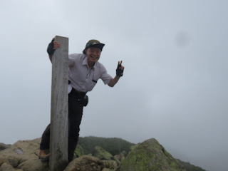
[At the top of Manaitagura, 俎嵓(まないたぐら)山頂にて、마나이타구라 정상에서]
Manaitagura was a pile of rocks. There was no hiker but me. There was only a wooden pole on the summit.
[At the top of Shibayasugura, 柴安嵓(しばやすぐら)山頂にて、시바야스구라 정상에서]
From Manaitagura to Shibayasugura, I walked down for about 50 meters, then I climbed up the steep slope for another 50 meters. When I arrived at Shibayasugura, there were two lady hikers on the summit.
I could see Ozegahara (尾瀬ヶ原) field from the summit clearly. I ate a cup noodle and some “onigiri” for my lunch.
[Lake Ozenuma from Mt. Hiuchi, 燧ヶ岳からみた尾瀬沼、히우찌가다케에서 본 오제누마]
When I began descending the summit, I slipped and fell down. I took the trail called “Miharashi Shindo (見晴新道)” but it was really a bad trail.
[A thistle flower along the trail, 下山路のアザミの花、하산로 엉겅퀴 꽃]
The slope was steep and muddy. I slipped 4 more times until I completely came down to Miharashi area.
There are several lodges in Miharashi and I checked in “Ozegoya (尾瀬小屋)” which is located next to Ozegahara field.
It was 4 p.m. so I just walked 12 hours that day. I could take a bath in the lodge and supper time was at 5:30 p.m.
[2nd Day at Oze: Mt. Shibutu (至仏山2228m) 9/5]
Breakfast was served at 6 a.m. I had a good appetite and ate a couple of bowls of rice. I left the lodge at 6:30.
[Breakfast at the lodge, 山小屋の朝食、산장의 아침 식사]
I walked on wooden trails toward Mt. Shibutu. Oze fields are divided into two parts: Fukushima side and Gunma side.
[Mt. Hiuchi in the cloud, 雲がかかる燧ヶ岳、구름이 걸린 히우찌가다케]
Oze field in Fukushima side looked like less water than Gunma side. I like Gunma side where there are more “chito (池塘)” ponds with “Oze kohone (オゼコウホネNuphar japonica or East Asian yellow water-lily).”
[At Oze Field, in front of Mt. Hiuchi, 尾瀬ヶ原にて、오세가하라에서]
Probably because of unfavorable weather, a few hikers walking in the field. I passed by only a few hikers that day.
[At Oze Field National Park, 尾瀬国立公園内の尾瀬ヶ原にて、오제 국립 공원의 오세가하라에서]
[Mt. Hiuchi and "Chito" pond, 燧ヶ岳と池塘、히우찌가다케과 "지탕"]
I enjoyed nice views of Mt. Hiuchi when I looked back, and I also enjoyed viewing Mt. Shibutsu while waking ahead.
I reached at Yamanohama (山の鼻) after walking for about 90 minutes. Yamanohana is at the bottom of Mt. Shibutsu. There are several lodges there. I took a short break there, then began climbing Mt. Shibutsu.
[At Yamanohana area,山の鼻付近にて、야마노하나 부근에서]
The track leads to the summit of Mt. Shibusu was much better than those of Mt. Hiuchi. There was no muddy part and I could see Oze Field whenever I looked down.
[At the entrance of the trail,至仏山山頂に至る登山道入り口、시부쓰산 정상에 이르는 등산로 입구]
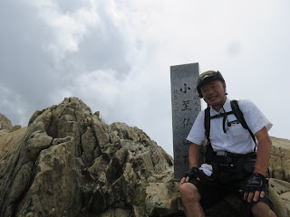
I reached at the summit of Mt. Shibutsu at around noon. There were several hikers, all together about 10 people.
[At the top of Mt. Shibutsu, 至仏山山頂にて、시부쓰산 정상에서]
I saw magnificent views of far-away mountains from the summit.
It took about two hours from the summit to “Hatomachi Pass (鳩待峠)” from which shuttle buses are available to Tokura (戸倉).
I was supposed to change buses but I misunderstood the bus stop for the direct bus to Shinjuku from Tokura.
The shuttle bus stop where I got off was not the bus stop for the direct bus to Shinjuku.
When I realized my mistake, it was after the direct bus gone.
I had to take a local bus to Numata (沼田) from Tokura. Then I took JR train from Numata to Ofuna via Takasaki (高崎).
My carelessness cost extra time and expense that day. I should be more careful when I travel next time.
------------------------------------------------------------------------------------------
KR (Kamakura Report) #3「尾瀬国立公園」
9月のガイド・ヘルパー活動は、台風の影響によるキャンセルもあり24件だった。8月に比べれば炎天下のエスコート事例は少なかったがそれでも汗を流した。
9月中旬には妻がシドニーから一時帰国し、日本での共同生活を楽しんでいる。
趣味の登山活動は9月3日~5日の尾瀬一泊旅行と下旬の9月25日~26日の北八ヶ岳とどちらも単独山行を楽しんだ。
今回は尾瀬国立公園の燧ヶ岳及び至仏山の登山を紹介する。
9月上旬の尾瀬山行は8月の富山県の奥大日同様、天候は雨天で始まった。9月3日の夜は雷雨で、横浜では落雷があり、夜行バス(22:20発)の新宿ターミナルへのアクセスに多少困難があった。
悪天候のためか乗客は10人未満で大清水に9月4日の早朝3時45分に到着。早い朝食後、一ノ瀬に向かって登山を開始した時、雨は止んでいた。
[初日・燧ヶ岳(2356m)登山9/4]
大清水から一ノ瀬までは道路が整備され、シャトルバスも出ているようだ。約1時間半、車道を進んで、一ノ瀬から山道に入る。
[The entrance of the trail, 一ノ瀬登山口付近、이치노세 등산로 입구 부근]
一ノ瀬からさらに1時間半、山道を進んだとこで三平峠に到達したころ降り出した雨は、尾瀬沼に到着し、長蔵小屋付近で本降りになった。
[At Sampei Pass, 三平峠にて、산페이 고개에서]
長蔵小屋の無料休憩所で休憩し、ビジターズセンターを見学しているうちに雨は小降りになったので燧ヶ岳(2356m)山頂を目指して登山を決行した。
[Lake Ozesuma and Mt. Hiuchi, 尾瀬沼と燧ヶ岳、오제누마 와 히우찌가다케]
[Free Lodge of "Chozogoya". 長蔵小屋無料休憩所、조우조 산장 무료 휴게소]
登山道の長英新道は小川のように水が流れていたが、途中でカラフルなキノコや、眠たそうな目をしたヒキガエルに遭遇した。
[A mushroom along the trail, 登山路で見つけたキノコ、등산로에서 본 버섯]
[A toad I found along the trail, 登山路で見つけたヒキガエル、등산로에서 본 두꺼비]
大清水でバスから降りて登山を開始してから約8時間、12時半に最初の山頂に到達した。
[At the top of Manaitagura, 俎嵓(まないたぐら)山頂にて、마나이타구라 정상에서]
燧岳の山頂は2つあり、1つは俎嵓(まないたぐら)で、もう1つは柴安嵓(しばやすぐら)である。
俎嵓は岩だらけの山頂で足場も悪く、自分以外に人はいなかった。
俎嵓をいったん下り、山の背を抜け、再び急坂を登ると柴安嵓であり、時刻は午後1時。
[A thistle flower along the trail, 下山路のアザミの花、하산로 엉겅퀴 꽃]
柴安嵓には立派な標石もあり、たぶん私と同年配の女性のハイカー2人が休憩中だった。
このころ雨は完全に上がり、眼下に尾瀬ヶ原が見えてきた。
燧ヶ岳からの下りは見晴新道を使った。この道は実に悪路で、勾配が急でしかもぬかるみ、なんと5回も滑って転倒してしまった。
[A thistle flower along the trail, 下山路のアザミの花、하산로 엉겅퀴 꽃]
午前4時に登山を開始してちょうど12時間後の午後4時に山小屋の密集する見晴に到着した。
今回は尾瀬ヶ原に一番近い、尾瀬小屋で一泊した。山小屋の入浴時刻に間に合い、入浴後おいしい夕食をたべた。
[尾瀬二日目:至仏山(2228m)登山9/5]
至仏山登山。午後は雨になると言われ、行程を急いだ。朝は6時朝食で、若者グループはその前に出発したようだ。朝から食欲があり、飯は2回お代わりした。
[Breakfast at the lodge, 山小屋の朝食、산장의 아침 식사]
至仏山は上部が雲の中だが、燧ケ岳は全容がみえた。福島県側は水が少なく、原の部分が勝っているようだが、群馬県側は池塘も多く、オゼコウホネの葉の紅葉が始まっていた。
[Mt. Hiuchi in the cloud, 雲がかかる燧ヶ岳、구름이 걸린 히우찌가다케]
ハイカーは少なく、途中から後ろについた女性二人組が追いかけられるようで気になった。尾瀬ヶ原横断は1時間半。至仏山荘前で休憩。
[At Oze Field, in front of Mt. Hiuchi, 尾瀬ヶ原にて、오세가하라에서]
山の鼻からの登山道は見晴らし新道に比べれば雲泥の差でぬかるみもなく歩きやすい。
[At Oze Field National Park, 尾瀬国立公園内の尾瀬ヶ原にて、오제 국립 공원의 오세가하라에서]
[Mt. Hiuchi and "Chito" pond, 燧ヶ岳と池塘、히우찌가다케과 "지탕"]
尾瀬ヶ原を眼下に見ながら気持ち良い登りで、山頂にはちょうど正午についた。山頂付近は単独ハイカーが3~4人、3人組が1グループのみだった。
[At Yamanohana area,山の鼻付近にて、야마노하나 부근에서]
至仏の山標は立派なもので、昼食はカップラーメンと残ったにぎり飯で、小至仏に向かった。
[At the top of Mt. Ko-shibutu, 小至仏山山頂にて、코시부쓰산 정상에서]
尾根道も快適で、鳩待ち峠には14:15に到着。看板には次のバスは14:30となっていたが、すぐに出るからと言われて乗り合いタクシーに乗って戸倉へ向かった。
戸倉からは帰路の乗り合いバスに乗り換えなければならなかったが、この連結が悪く、乗り合いタクシーで降ろされた場所で新宿行きのバスを待っていたら、予定の時刻になってもバスが現れない。
バス乗り場はタクシーで降りた場所から約100m離れた日帰り温泉の隣だった。
新宿直行バスはすでに出た後だったので、やむを得ず、沼田行きのローカルバスに乗り、沼田からJRで高崎に出て、高崎から東海道線に乗り換えて大船へ戻った。
[In front of JR Numata Station, JR沼田駅前、JR 누마타 역 앞]
帰路は私の勘違い、不注意により、時間を費用が余分にかかることとなった。
次回はこのようなことがないよう、注意深く行動したい。
--------------------------------------------------------------------------------------
I like hiking very much. I used to go hiking with a Korean hiking club named “AhToSan.” This blog introduces mostly my hiking activities in Korea and Japan, and Sydney in Australia. As of January 2020, I live in Sydney suburb. I go Blue Mountains and bush walk in Sydney area. 私は2003年から2014年まで韓国の大田(テジョン)に住んだ日本人である。11年間、週末は主に「アトサン山岳会」に参加した。14年4月に帰国したが、2020年以降はおもにシドニーで暮らし、時折、日本へ帰国する程度である。したがって最近の記事はSR(Sydney Report)としてブルーマウンテンのトレッキングを中心に書いている。
About pictures/当ブログ内の写真について/당 블로그내의 사진에 대해서
Most of the pictures in this blog are taken by my camera, yet some of them were downloaded from the website of the hiking club. If you click any pictures, they become the original size.
当ブログ内の写真の大部分は筆者のカメラで撮影したものですが、一部、山岳会の共有写真からダウンロードしたものを含みます。すべて、各写真をクリックすれば、元のサイズに拡大します。
당 블로그내 사진의 대부분은 필자의 카메라로 촬영한 것입니다만 일부 산악회 공유 사진으로부터 다운한 것도 포함합니다. 모두 각 사진을 클릭하면, 원래 사이즈에 확대합니다.
当ブログ内の写真の大部分は筆者のカメラで撮影したものですが、一部、山岳会の共有写真からダウンロードしたものを含みます。すべて、各写真をクリックすれば、元のサイズに拡大します。
당 블로그내 사진의 대부분은 필자의 카메라로 촬영한 것입니다만 일부 산악회 공유 사진으로부터 다운한 것도 포함합니다. 모두 각 사진을 클릭하면, 원래 사이즈에 확대합니다.


