About pictures/当ブログ内の写真について/당 블로그내의 사진에 대해서

Most of the pictures in this blog are taken by my camera, yet some of them were downloaded from the website of the hiking club. If you click any pictures, they become the original size.

当ブログ内の写真の大部分は筆者のカメラで撮影したものですが、一部、山岳会の共有写真からダウンロードしたものを含みます。すべて、各写真をクリックすれば、元のサイズに拡大します。

당 블로그내 사진의 대부분은 필자의 카메라로 촬영한 것입니다만 일부 산악회 공유 사진으로부터 다운한 것도 포함합니다. 모두 각 사진을 클릭하면, 원래 사이즈에 확대합니다.

2020年9月30日水曜日

SR 27 “Status Quo of COVIT-19 and Health Management,” “GNW Challenge in September,” “Railroad Station You Need to Wave Your Hand.”# 27 「新型コロナ感染状況と健康管理」「9月のGNW挑戦」「手を振って列車を止める駅」

SR 27 “Status Quo of COVIT-19 and Health Management,” “GNW Challenge in September,” “Railroad Station You Need to Wave Your Hand.”

“Status Quo of COVIT-19 and Health Management”

The second wave of COVIT-19 happened in the state of Victoria, the south of NSW this winter.

[Confirmed casess, cumulative in Australia, 豪州における累計感染者数、호주의 누계 감염자 수]

It started in the late June and the daily percentage of the expansion was 15.7% on July 1 this year. Now it is as low as 0.1 % as of Sep. 28.

[New daily cases in NSW and Victoria, NSW州およびビクトリア州における新規感染者数の推移、NSW 주와 빅토리아 주에서 신규 감염자 수의 추이]

The situation of NSW is much better. Since the late May when they started deregulation, there seems no serious 2nd wave at all until today.

I assume that weakening one’s immune strength due to the lack of exercise is more serious problem.

Therefore, I utilize “health app” of smart-phone and counting daily walk-steps. Distance and stairs and keep records of them.

[Health Management App in Smartphone, スマホの健康管理アプリ、스마트 폰의 건강 관리 앱]

While I was in Japan, I used to work as “Guide-helper” for people with disabilities. When I had free time, I used to climb mountains in Japan.

Since I came to Sydney, I have no such “walking-job.” So, I just consciously do “bush-walking.”

Average daily walking steps in the past year: about 20,000 steps.

Average daily walking distance is about 12 km.

[Monthly average daily walking distance,月別平均一日の歩行距離、월별 평균 하루 도보 거리]

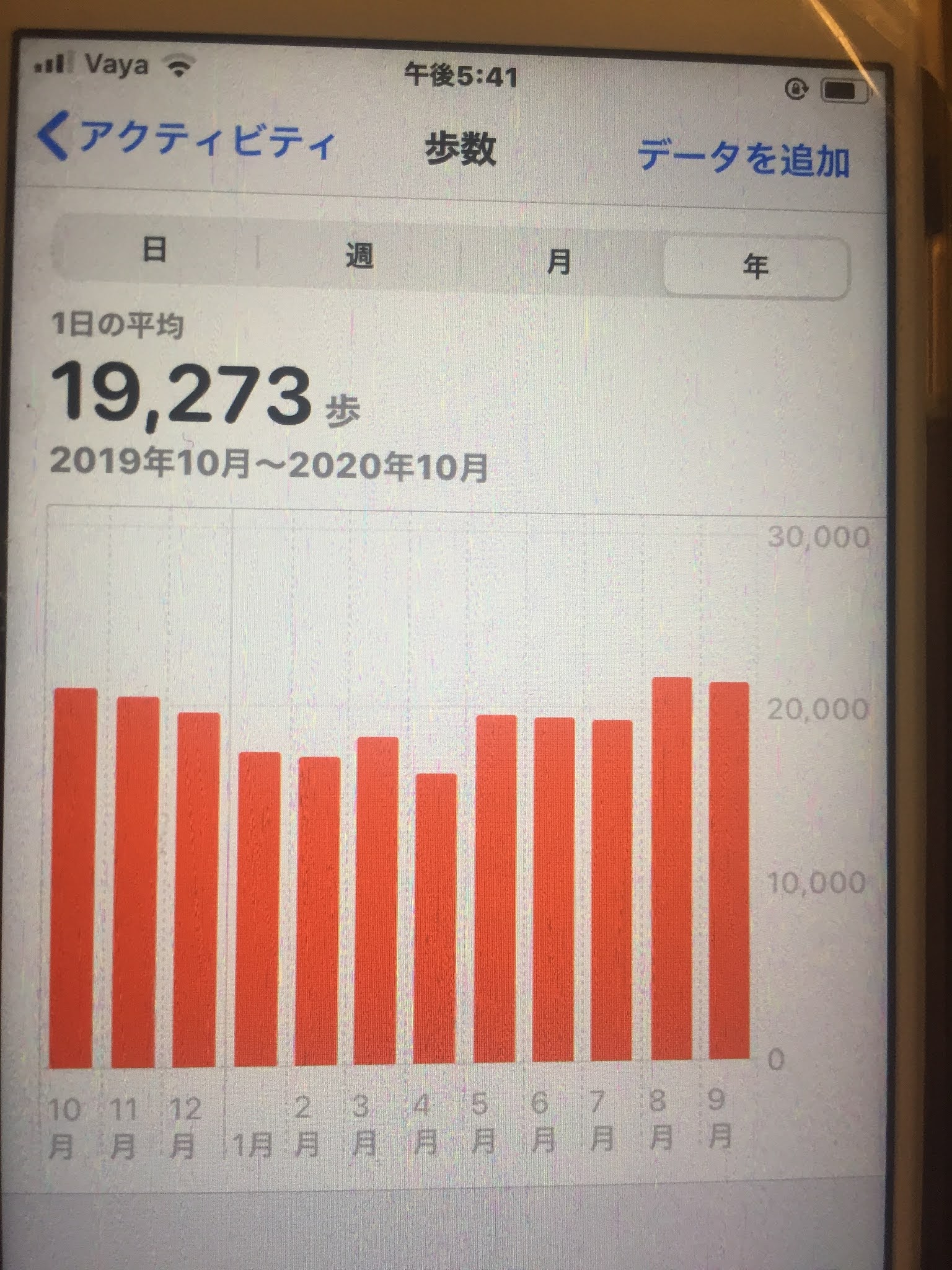
Average daily climbing stairs are 33 stairs (if you climb 3 miters up, then it is counted as 1 stair.)

[Monthly average number of floors per day, 月別平均1日当たり上った階数、월별 평균 하루에 오른 층]

If you see the graph above, you can see the rise in the past half a year, from 16 stairs to 50 stairs constantly. (Actually it is the highest average stairs in the pas two years.)

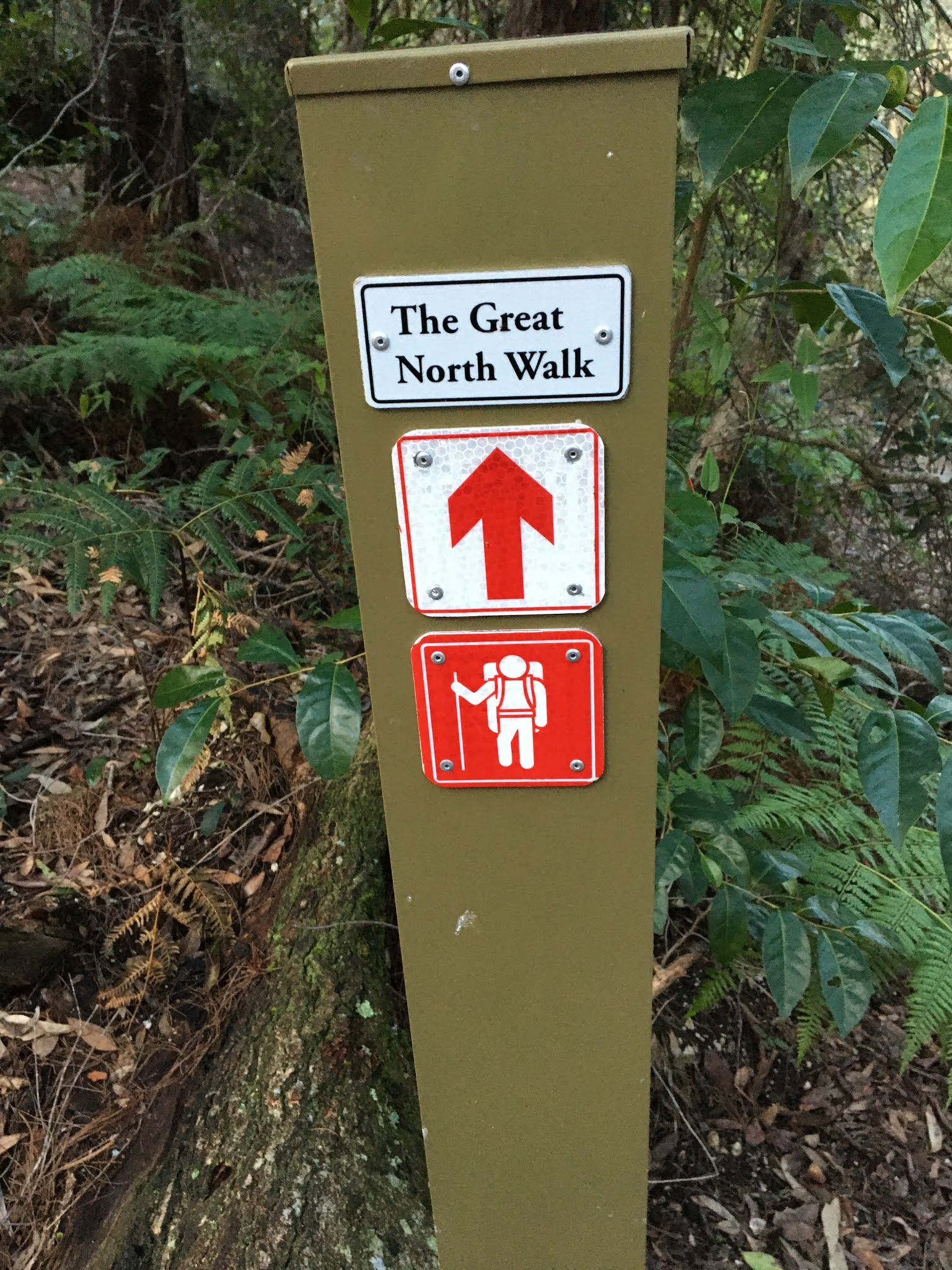
“GNW Challenge in September”

I have been challenging the Great North Walk (GNW) which is a 260 km walking track connecting Sydney and Newcastle in the past 3 or 4 months.

In September, I challenged the Northward from Hornsby up to Wonderbyne just before Woy Woy station.

I especially enjoyed “Berowra Valley National Park” which spread above Hornsby to Berowra.

[Grey Spider Flower, グレー・スパイダー・フラワー、그레이 스파이더 플라워]

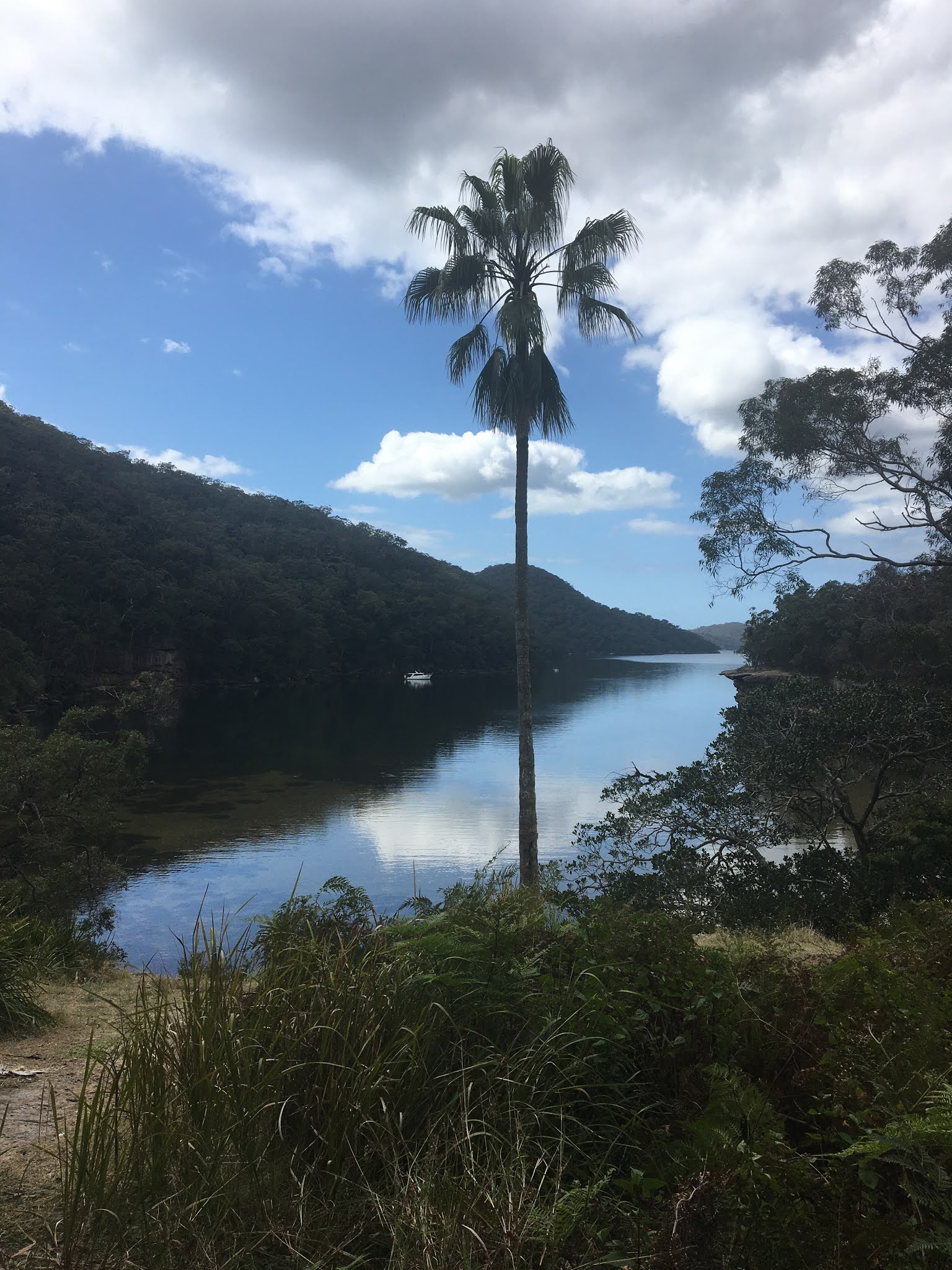
GNW #10 is from Berowra Station to Berowra Waters (5.7 km), and #11 is from Berowra Waters to Cowan Station (7.2 km). There is no public transportation available to Berowra Waters, so Isaac and I walked these two sections within one day.

[Berowra Waters, ベロウラ・ウォーターズ、베로우라 워터스]

It was hard because of steep up and down, but not too hard because the distance was reasonable, 12.9 km all together.

Actually it was so nice and two other hikers joined us for our second challenge and we walked together.

GNW #12 was also very attractive. It is from Cowan Station to Hawkesbury River (13.4km.) This track is called “Jerusalem Bay Track,” because it goes through this beautiful Jerusalem Bay. Again Isaac and I walked this track twice this month.

[At the track-head with Isaac, トラックヘッドにて、アイザックと、트랙 헤드에서 이삭과 함께]

[At Jerusalem Bay, エルサレム湾にて、예루살렘 베이에서]

The highlight of this month GNW was #13 from Patonga to Wonderbye Station (19.5 km).

There is no public transportation access to this Patonga Warf except by “water-taxi.” Since the walking distance is rather long (19.5 km), we took an early train and arrived at Hawkesbury Station at 8:45 am.

We called the water-taxi, but had to wait more than 30 minutes. It came to the pier at 9:40 am. We paid A$ 100 and arrived at Patonga Warf at 9:55 am.

[We took Water-taxi from Hacksbury River,ウォータータクシーでパトンガ海岸へ向かう、수상 택시로 빠톤가 해안으로 향했다]

Patonga Beech was beautiful, and we could find the GNW marks easily which led to the track-head at the edge of the beach.

[We landed on Patonga Warf, パトンガ埠頭へ上陸、빠톤가 부두에 상륙]

[Patonga Beach,パトンガ・ビーチ、빠톤가 비치]

According to the GNW guide book, the first point of this track was “Warah Trig Statin.” I was wondering that kind of “station” but it was a kind of landmark we often find in the tops of mountains as “triangulation station” in Japan.

[Warah Trig Statin、ワラ・トリッグ・ステーション(三角点)、와라 기준 삼각점]

After “Take-five” at this station, we came to the track with several red flowers called “waratah” along side.

[Waratah flower (flower of NSW, ワラタ(NSW州花)、와라타 (NSW 주화)]

According to some web-site explanation, “waratah” means “red flower tree” in aborigine language. As floral language, “Watch Me” or “Stand Out” flower.

“Railroad Station You Need to Wave Your Hand.”

According to GNW Guide Book, this #13 section is 19.5 km long, and it needs 7.5 hours.

We landed at Patonga Warf at 10 am, so Isaac and I hurried to arrive at the destination, Wonderbyne Station before sun-set.

After passing Mt. Wonderbyne, we went down in the valley, and saw a beautiful waterfall, called Kariong Brook Waterfall. Then we climbed in the steep slope and walked down to the seashore.

[Kariong Brook Waterfall, カリオング・ブルーク滝、카리온구 브룩 폭포]

We arrived at Wonderbye Station at the seashore at 16:45. This is really a small station.

[Wonderbyne Station, ワンダーバイン駅、원더 바인 역]

The platform is about 20 meters. And it is necessary to stop the train by waving your hand toward the driver of the train.

While we were waiting the train, a young couple came to the station by their small boat. They are the residents across the shore.

There are no house around the station, and they need to go shopping by using the train.

We did waved our hands to stop the train. The scenes you can see through the windows are beautiful. They reminded me of the scenes along Enoden Line.

-------------------------------------------------------------------------

# 27 「新型コロナ感染状況と健康管理」「9月のGNW挑戦」「手を振って列車を止める駅」

「新型コロナ感染状況と健康管理」

オーストラリアにおける新型コロナ感染拡大の第2はNSW州の南隣であるビクトリア州で起こった。

[New confirmed cases, daily count,日々の新感染者数の推移、매일 새로운 감염자 수의 추이]

6月下旬に始まり7月1日時点の1日当たりの拡大率は15.7%だった。しかし8月初めごろをピークに、現在(9/28)は0.1%まで下落している。

[New daily cases in NSW and Victoria, NSW州およびビクトリア州における新規感染者数の推移、NSW 주와 빅토리아 주에서 신규 감염자 수의 추이]

私の住むNSW州では5月下旬の規制緩和以来、第2波もないようで、順調に推移している。

私には外出自粛による運動不足で免疫力の低下のほうが問題であると思える。

私は運動量の管理はスマホの健康アプリを用いている。このアプリを用いると歩数、歩行距離、上がった階数が日々の記録とともに週間、月間、年間の平均を見ることができる。

[Monthly average number of steps per day,月別平均1日当たりの歩数、월별 평균 일일 걸음]

私は日本にいるときは「ガイド・ヘルパー」の仕事で歩くし、仕事のないときは登山を好む。

シドニーでは仕事がないためもっぱら自ら意識してブッシュウォークすることを掛けている。

年間平均して日々の歩数は2万歩前後、歩行距離は12km前後、階段数は33階である。

項目別に月別にみる4月は50km以遠の移動も禁じられたため、すべて年間最低値であったが、その後、ブルーマウンテンに加え、ザ・グレート・ノース・ウォークも始めたため、特に階段数はしり上がりに増加し、この2年間で最多の50階超となっている。

「9月のGNW挑戦:#9~13」

シドニーからニューキャッスルまで続く260kmの「ザ・グレート・ノース・ウォーク」は私の住むチャッツウッドから約20km北のホーンズビー周辺から渓谷も深くなり、入江も入り組んでトレッキングのだいご味が増す。

ホーンズビーからさらに北に位置するベロウラは「ベロウラ渓谷国立公園」で美しい風景が多い。9月はオーストラリアは春であり、珍しい固有種の花も一斉に咲きさらにトレッキングの魅力が増す。

[Grey Spider Flower, グレー・スパイダー・フラワー、그레이 스파이더 플라워]

#10のベロウラからベロウラ・ウォーターズまでの5.7kmと#11のベロウラ・ウォーターズからコウワンまで(7.2km)の2区間は中間のベロウラ・ウォーターズへの公共交通手段によるアクセスがないため、2区間を1日で歩かねばならない。

[Berowra Waters, ベロウラ・ウォーターズ、베로우라 워터스]

この区間は高低差が下り600m/上り490mでかなりきつい。しかし、箱根の芦ノ湖を思わせるベローラ・ウォーターズが特に気に入り、最初はアイザックと二人で、2度目はさらに2人が加わって4人で歩いた。

[A hard part of the track, 登頂困難な個所、등정 어려운 곳]

第12区間のコウワン~ホークスベリー・リバーまでの13.2kmも「エルサレム湾トラック」の別名がある美しい景観が楽しめる区間で、実際、アイザックと私は2回、同じコースを歩いた。

[At Jerusalem Bay, エルサレム湾にて、예루살렘 베이에서]

この区間の高低差は下り600m上り780mでさらにきつかった。しかしきつかった渓谷の上部で、オーストラリアで初めて食虫植物のモウセンゴケの群落を見たのはうれしい発見だった。

[Drosera rotundifolia community、モウセンゴケの群落、끈끈이 주걱 군락]

[Pink Wax Flower (Eriostemon australaisus)、ピンク・ワックス・フラワー、핑크 왁스 플라워]

この第12区間の目的地のホークスベリー・リバーまではシドニーとニューキャッスルを結ぶ沿線の駅を出発地と目的地にすればよい。途中駅のない区間は2区間を一日で歩けば問題ない。

しかし次の第13区間(19.5km)の出発点はパトンガという海岸で、第12区間の目的地のホークスベリー・リバーからは水路を使わなければならない。ガイドブックによると公衆フェリーが存在した時もあったようだが、現在は運行していないため、アイザックと私は料金100ドルのウォーター・タクシーを利用した。

ウォーター・タクシーは個人営業のようで、携帯電話で連絡すると留守番電話になっていて自分の電話番号を録音して相手からの連絡を待った。

[We took Water-taxi from Hacksbury River,ウォータータクシーでパトンガ海岸へ向かう、수상 택시로 빠톤가 해안으로 향했다]

連絡を待つこと約30分。ようやくウォータ・タクシーに乗船して約15分で美しいパトンガ・ワーフに上陸した。

[Patonga Beach,パトンガ・ビーチ、빠톤가 비치]

パトンガ・ワーフからは小さいながら「ザ・グレート・ノース・ウォーク」が海岸端のトラックヘッドを示していた。

[At the track head with Isaac, トラック・ヘッドにてアイザックと、트랙 헤드에서 이삭과 함께]

このトラックの最初の目標は「ワラ・トリッグ・ステーション」となっていたのでどんな駅だろうと思ったら、どうも日本でいう三角点のような建造物だった。

この先は見晴らしのよい、岩場の道が続いたが、途中、NSW州の州花である赤い大きな「ワラタ」の花が点在するブッシュを歩いた。

[Waratah flower (flower of NSW, ワラタ(NSW州花)、와라타 (NSW 주화)]

「ワラタ」とは先住民の言葉で「赤い花の木」という意味で、花言葉は「どこにいても目立つ人」/「目立ちがり屋」とネットにあった。

「手を振って列車を止める駅:ウォンダーバイン駅」

この第13区間はガイドブックによると距離が約19.5kmで所要時間が7.5時間である。

我々がウォータータクシーで下船した時刻が10時近かったので、目的地のウォンダーバイン駅に到着する時刻が日没以降になることを恐れた。

ウォンダーバイン山を下ったところでカリオング・ブルーク滝に下り、そこから最後の上り勾配を上がると、後は一気に海岸のすぐわきにあるウォンダーバイン駅に下る道で到着時刻は日没前の16:45だった。

[Wonderbyne Station, ワンダーバイン駅、원더 바인 역]

この駅はホームの長さが約20mなので、8両編成の列車の最後部の1両しかドアが開閉しない。

この駅で下車する人は必ず最後部に乗車する。また、この駅から乗車する人は先頭車両が視界に入ったら運転手に手を振って合図しなければならない。

アイザックと私がホームで列車を待っていると、対岸の家の住民という30代くらいのカップルが小さな船に乗ってやってきた。

彼らはボートをホームの下の杭につなぐと我々と一緒に列車を待った。この駅の周囲には人家はまったくなく、彼らは隣駅へ食料品などを買い出しに行くところだという。

t[At the platform of Wonderbyne Station, ウォンダーバイン駅のプラットホームにて、원더 바인 역 플랫폼에서]

ウォンダーバイン駅から隣のホークスベリー・リバー駅までの車窓の風景は江ノ電の七里ガ浜付近を思わせる実に美しい風景だった。

2020年9月6日日曜日

SR #26 “GNW: The Longest One Day Walk” “Restart of Thursday Hike” “Taichi by Zoom”SR 26号 「GNW:最も長い日帰りウォーク」「木曜トレッキング再開」「タイチの会、ズームで再開」

SR #26 “GNW: The Longest One Day Walk” “Restart of Thursday Hike” “Taichi by Zoom”

“GNW: The Longest One Day Walk”

The Great North Walk (or GNW) is a 250 km path from central Sydney to downtown Newcastle in Australia. It is a truly wonderful trail following many tracks through a bewildering array of natural and urban environments.

There are 30 short tracks from Sydney to Newcastle.

http://www.thegreatnorthwalk.com/track/

Chatswood locates in the north of Sydney, so I am familiar with many parts of the 1st section to the 4th section. But not so from the 5th section (from Macquarie Park to Thornleigh.)

Isaac, an ardent hiker of Saturday Hiking Group, joined me for this new explore of walking GNW every week.

We usually access start-points by train, and after arriving at destinations, we go back by train.

When we tried No. 7 (from Hornsby to Galston Gorge) and No. 8 (from Galston Gorge to Mt. Kuring-Gai), we had a problem. There is no public transportation to/from Galston Gorge.

According to the explanation of the above site, #7 section is a 4 hour 9.7 km one way hike and #8 section is a 5.5 hour 12.6 km one way hike and both are hard tracks.

If we walk these two sections for one day, it will be a 9.5 hour 22.3 km walk. So we started at Hornsby station at 8:30 am on Aug. 11.

[Isaac on Blue Gum Walk of GNW, GNWの「ブルーガムウォーク」,GNW의 "블루 검 워크"]、

First half of #7 section was all right but we lost the GNW mark, therefore, we began using GSP function of our smartphones, and walked the paved road to Gaston Gorge.

We arrived at the gorge at 12:30.

[At Galston Gorge, ギャルストン・ゴージにて、갸루스톤 협곡에서]

There were much water in the gorge, so, walking the paved road was safer than walking GNW.

After having quick lunch, we began walking the #8 section before 1 pm. Most part of section 8 is along the part of the big river or a shallow bay.

[At Berowra Valley National Park, ベロウラ渓谷国立公園にて、베로우라 계곡 국립 공원에서]

However we had to walk across small cleeks.

When we arrived Crossland, about the middle of the section, it was already after 4 pm. Moreover, we took the wrong trail, not to Mt. Kuring-Gai, but the trail to Berowra.

[At Crossland Wet Field, クロスランド湿原にて、크로스 랜드 습지에서]

Along the GNW, we could see the marks, but it is difficult when it gets dark. When we arrived at the point from where the statin was only 2 km, it was completely dark.

[The mark of GNW(Great North Walk), GNWの標識、GNW 표지판]

Isaac had a head-light, but I did not have one. Unfortunately his head-light did not work. We had to use our smartphones as flashlights and at the same time we also use GSP functions.

[Sun-set at the Berowra Valley,ベロウラ渓谷の日没、베로우라 계곡의 일몰]

When we lost GNW marks, it was only 500 meters from the station. But that 500 was really ordeal for us. We barely went through this crisis and arrived near city street at around 7 pm.

Total walking distance for that day was 34.6 km, 48,057 steps, and 120 floors (My health app counts 3 meter elevation as 1 floor.)

We both thanked God for his protection from any possible harms, but we must be more careful for planning, and preparation in the future.

“Restart of Thursday Hike”

Before this COVIT-19 pandemic situation, I used to walk with some Chinese friends and a Japanese friend every Thursday.

The leader is called Marshall from Taiwan. His parents came to Taiwan from mainland China and he was born in Taiwan in 1949.

He is a fluent speaker of English and he really knows well about this neighborhood trekking courses. He also knows local plants and often explains about these plants.

[Traveler's banana, トラベラーズ・バナナ、"트래블러스" 바나나(여행자의 음용)

) During the lock down period, my Japanese friends in Japan shifted the face-to-face meeting to zoom meeting. When they started zoom meeting, I joined this English study group, Day-KEC meeting on Thursday.

[Day KEC Zoom Presentation、Day KECのズーム・ミーティング、디켓쿠 줌 회의]

That’s why even the lockdown ended in June, I could not join Thursday hiking group.

But Marshall suggested that the trekking activities be held in the afternoon. So I leave the zoom meeting 30 minutes early, then I meet Marshall at 1:30 pm at Salvation Army Chatswood. We enjoy 2 ~ 3 hour bushwalks every Thursday.

[Marchall at Davidson Park, ディビッドソン公園にてマーシャル、디빗도손 공원에서 마샬]

Marshall is not a Christian. But he does not hesitate to talk about religion. He does not hesitate to talk about the world histories including the Japanese armies brutal acts in China. Sometimes we have heated discussion. But I am happy to listen to his opinions of different perspective.

[Middle Cove National Park,ミドルコーブ国立公園、미도루코부 국립 공원]

However he takes me for trekking within radius of 10 kilometers from our houses, and they are many scenic areas of residential zone.

“Taichi by Zoom”

Wednesday is busy with zoom meeting. I usually attend Aussie’s Bible Study every Wednesday morning, and Japanese Taichi class in the afternoon.

Now the both meetings are being conducted by zoom meeting because of COCIT-19.

As for Taichi lessons, it was organized by the Japanese Society in Chatswood.

The teacher, Mr. Hosaka has been in Sydney several decades. He was born in 1930s. Yet he is very active and teaches us Taichi kindly.

[Mr. Hosaka at the new year party, 新年会にて保坂師範、신년회에서 호사카 사범]

[At New Year Party befor COVIT-19 Pandemic, 武漢肝炎拡大前の新年会にて、무한 간염 확대 이전 신년회에서]

Some of the members used to have chatting at the lounge of Chatswood RSL bar over some sips of beverage. I became a member of RSL in January. Then this the lockdown came.

However, in August, they re-started this Taichi lessens by utilizing zoom functions. I am happy to see Mr. H again, and other Japanese friends every Wednesday afternoon.

I really hope that the situation becomes much better and we can meeting face-to-face again, and enjoy sipping at RLS bar from time to time in the near future.

----------------------------------------

SR 26号 「GNW:最も長い日帰りウォーク」「木曜トレッキング再開」「タイチの会、ズームで再開」

「GNW:最も長い日帰りウォーク」

「ザ・グレート・ノース・ウォーク(GNP)」はシドニーからニューキャッスルまで全長250kmの道である。シドニーのマッコーリー・プレース公園からニューキャッスルのクィーンズ・ワーフまでを30区間のショートトラックに区分して説明しているサイトがある。

http://www.thegreatnorthwalk.com/track/

私の住むチャッツウッドはシドニーの北部にあり、第1区間から第4区間まではいわば近隣地帯で、かなり近い部分をこれまでも歩いてきた。

ここからさらに北に向かって毎週1回のペースで歩いている。7月からは土曜のグループの一人が私と一緒に歩き始めた。

アイザックという韓国人ハイカーでパラマッタ近郊に住んでいる。彼は熱心なハイカーで多少悪天候であっても付き合ってくれる。

彼と私はGNWに沿って走っている出発点最寄りの駅に集合し、トレッキング後、目的地最寄りの駅から、電車でシドニーに戻る。

しかし、第7区間と第8区間の中間のギャルストン・ゴージ(Galston Gorge)には利用可能な交通機関がない。合計距離は22.3 km、高低差は845m、所要時間は9時間30分である。これは道迷いをしなかった場合で、道迷いをすれば当然距離も時間も長くなる。

我々はホーンズビー駅を8:30に出発した。はたして、途中、道迷いをした。上記サイトで打ち出した地図をあきらめ、スマホのGPS機能を利用し、車の走る舗装道路を歩いてGalston Gorgeに到着した。

[Isaac on Blue Gum Walk of GNW, GNWの「ブルーガムウォーク」,GNW의 "블루 검 워크"]、

ここは数日前の雨のため増水していて正規の道を歩いたらこの渓谷は渡ることはできなかったかも知れない。

[At Galston Gorge, ギャルストン・ゴージにて、갸루스톤 협곡에서]

この時点ですでに12:30を過ぎていたので昼食を軽く済ませ、13時前には午後の行程を出発した。

[At Crossland Wet Field, クロスランド湿原にて、크로스 랜드 습지에서]

ここでも道迷いをしたが、1番の問題は日没時間が迫ったことである。

クリークと呼ばれる谷川をいくつも超えてゆくが道迷いをしやすいのがこの川原である。川原では道標がわかりにくく、誤った方向へ行きがちである。

[The mark of GNW(Great North Walk), GNWの標識、GNW 표지판]

最後のクリークを超えて何とか渓谷の上部に出る急坂を上っているときに日没になった。

[Sun-set at the Berowra Valley,ベロウラ渓谷の日没、베로우라 계곡의 일몰]

渓谷の上は林道のような広い道で、大きな道標には駅まで2㎞と表示してあった。

[The mark says "2 km from the station",「駅から2km」という標識、"역에서 2km '라는 표지판]

やれやれこれで一安心と思ったが、アイザックのヘッドライトがつかない。スマホのライトを頼りに進んだが、林道は次の駅まで1500mという道標付近までで、その先はブッシュウォークの細い急坂であった。

今から思えばあと500mという地点で最後いの道迷いをした。我々はいわゆる「ヤブコギ」をして人家の前に出た。

スマホの予備バッテリーも残り少ない中、午後7時にベロウラ駅に到着した。

結局、この日の歩行距離は34.6km、歩数48,057歩、昇降階数120階という大トレッキングになった。

反省点が多いが、主に守られて感謝である。

「木曜トレッキング再開」

コロナパンデミックのため都市封鎖される前までは、木曜日は台湾から来て、近所に住む中国人のマーシャルおよび彼の友人のピーターと近隣のトレッキングコースを歩いていた。

マーシャルはチャッツウッド在住10年以上で、私の知らない風光明媚なコースを案内してくれる。

[Marchall at Davidson Park, ディビッドソン公園にてマーシャル、디빗도손 공원에서 마샬]

木曜日は日本ではDay-KECという英語会に参加していたが、この会がネットを利用してZoom会議を開くようになった。

[Day KEC Zoom Presentation、Day KECのズーム・ミーティング、디켓쿠 줌 회의]

この会は、日本では12時までだが、1時間の時差があるため、こちらでは13時までである。

私は30分早く退出して、午後1時半から出発する、マーシャルとのトレッキングを再開した。

マーシャルは英語が達者で、話題は歴史、政治、宗教などにおよび、かなり際どい議論となる。

[At Lyrebird Track、ライヤーバー・トラックにて、라이어바 트랙에서]

自分と異なる意見を持つ人と冷静に話し合うことは意外と難しい。しかし、学ぶとろこが多い。

「タイチの会、Zoomで再会」

水曜日の午前中はオージーの集まる聖書研究会に出席していた。しかし、ロックダウン以来、三密を避けるためしばらく休会になっていた。

しかし、こちらもZoom会議方式になって再会した。

また水曜日の午後は、日本人会の集まりで、太極拳(Taichi)を学んでいた。

こちらは日本人の集まりなので、交際を広げるのに欠かせない集まりである。

[At New Year Party of Japanese Taichi Group,日本人太極拳の会の新年会、일본인 태극권 모임의 신년회]

私もチャッツウッドのRSLクラブの会員になり、太極拳のあとのおしゃべりの時間にも参加しようとしていた矢先、ロックダウンですっかりごぶさたになってしまった。

しかし8月になってこちらもZoomで集会が再会された

。 こちらは実際に体を動かすので、Zoomでは勝手が悪いが、それでも仲間の顔を見ながら、お手本のビデオはZoomの共有サービスを利用すればできる。

私より10年以上先輩のH先生の熱心な指導をふたたび受けることができ、喜びもひとしおである。

私はトレッキングは毎日欠かさないが、柔軟体操はほどんどしていないため、太極拳の基本動作の指導を受けるたび、その必要性が痛感される。

いずれにせよ、このコロナ騒動が一日も早く収束してまた、RSLのラウンジでの気軽なおしゃべりができることを祈念するばかりである。