SR 41 "Bougainvillea and Giant Pine Cone" "Revenge Walk: GNW # 7 and #8 (From Hornsby to Mt. Kuring-gai via Galston Gorge"
"Bougainvillea and Giant Pine Cone"
I do relatively big trekking with Korean hikers such as Blue Mountains twice a week (Tuesday and Saturday). On other days, I walk almost the same course in the local park every day.
The area is Chatswood West and the name of the park is Ferndale Park. The park connects Chatswood Station to the Lane Cove River, a river that runs through the Lane Cove National Park, and has many tracks in the rainforest.
One of them is the entrance that looks like “no through road” and is my favorite course.
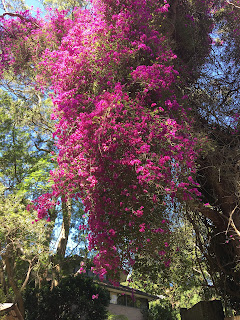
Standing at this entrance, many pink flowers are blooming like a waterfall from the height of a 6-story building. Looking at the ground, many petals are falling all over the road. They are bougainvillea.
>
[The giant bougainvillea,巨大なブーゲンビリア、거대한 부겐빌레아]
Bougainvillea is a genus of thorny ornamental vines, bushes, and trees belonging to the four o' clock family, Nyctaginaceae. It is native to eastern South America, found from Brazil, west to Peru, and south to southern Argentina. Different authors accept from 4 to 18 species in the genus. The inflorescence consists of large colorful sepal-like bracts which surround three simple waxy flowers.(From Wikipedia.)
[Many follen bracts on the road, 道路に落ちた包葉、도로에 떨어진 포엽]
This bougainvillea is as large as a 6-story building of flowers and there are many bracts fallen on the road, just like a colorful carpet.
[Bougainvillea flowers and bracts,ブーゲンビリアの花と苞葉、부겐빌레아 꽃과 포엽]
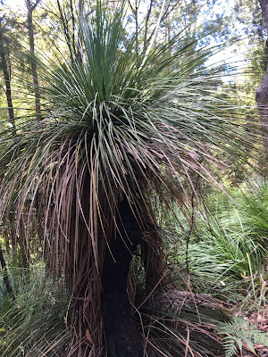
The bougainvillea is creeping around a tall tree on the left side. And there is another tall tree just before the bougainvillea. It is a Bunya Pine which bears huge pine cones.
[Bunya Pine tree, バンヤ・パイン(ヒロハナンヨウスギ),버냐소나무]
When I saw the pine cones for the first time, I was really surprised. They are as large as big sized watermelons.
I brought one of them to our share house and measured it. It was 4.5kg! If it hits a passer-by, it may kill the person. I’ll say it is dangerous.
[Huge pine cones (Bunya pine cones0,巨大な松ぼっくり、거대한 솔방울(열매)]
[Noah (my grandson) holds Bunya Pine Cone,バンヤ・パインの実を持つ孫、버냐 소나무의 열매를 들고있는 손자]
In addition, the cracked pine cones contain pine nuts that are 3 to 4 cm in size. It can be eaten raw and is delicious when baked or boiled in salt. It tastes like a savory chestnut.
[Broken Bunya Pine Cone,割れたバンヤ・パインの実、깨진 버냐 소나무의 열매]
By the way, Banya Pine is a living fossil plant that has existed since the Jurassic period (213.5 million to about 145.5 million years ago) when dinosaurs prospered, and dinosaurs may have eaten this fruit as well.
[Bunya Pine nuts (about 100 from one cone),1個の実から100個の種、1개의 열매에서 100개의 씨]
[Bunya Pine nuts,バンヤパインの実、버냐 소나무의 열매]
In Queensland, north of NSW, there is a park called Bunya Mountains National Park, where Bunya Pines grow naturally.
"Revenge Walk: GNW # 7-8"
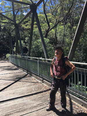
The Great North Walk (GNW) is a 260km track that connects Sydney to Newcastle. There are 30 sections suitable for a day trip, and there is no public access between # 7 and # 8, so we have to walk in one day at a stretch.
On August 11th, the year before last (2020), my trekking friend, Isaac and I walked on these tracks for the first time. But we repeated lost trails, and we could not reach the destination before sunset. Worse that our battery of the headlights ran out and lost our ways and walked through bush in the dark. Fortunately the ordeal ended within 30 minutes and we came out of the bush and arrived at Berowra, which was a wrong destination.
The outline of the official courses are as follows.
GNW # 7 Hornsby-Galston Gorge 9.7 km / 4 hrs / ↑ 473m Hard Track
GNW # 8 Galston Gorge-Mount Ku-ring-gai 12.6 km / 5.5 hrs / ↑ 846 m Hard Track
GNW # 7 + # 8: 22.3 km / 9 hrs 30 min./↑473m/↑846m Hard Track
By the way, ↑ is the height difference of the truck.
On August 11, 2020, we left Hornsby at 8:30 and arrived at our (wrong) destination of Berowra at 7:00 pm, so we walked for 10 hours and 30 minutes. However, we had a hard time because the season was winter and the sunset was around 5 o'clock.
This time (December 31, 2021), we left at 9 o'clock and arrived at the (right) destination of Mt. Kuring-gai at 5:30 pm. The walking time was 8 hours and 30 minutes, which was one hour shorter than the standard time. It can be said that our “revenge” was successful.
I will explain the outline of each main section as follows:
[Hornsby Station-Berowra Valley Bushland Park]
The Hornsby station and town are on the Highlands. There is a nice park with a 50-meter swimming pool near the station. There are signs of GNW before the park. If you follow the signs, looking the park on your right side, while paying attention to the motorcycle-only road, you will see a GNW sign and you will soon be on a downhill slope.
[A GNW sign at a junction, 分岐点のGNWの標識、분기점 GNW 표지]
Down this staircase you will reach Berowra Valley Bushland Park, which also has barbecue facilities. Christmas decorations were still installed here that day.
[A Chirstmas decoration at the park, 公園内のクリスマスの飾り、공원에 있는 크리스마스 장식]
[From Berowra Valley Bushland Park to Fishponds Junction]
This is a wide and comfortable road like a fire track with a forest of blue gum trees. This part overlaps with the "Blue Gum Truck". You can see huge rocks in the airy forest.
[A woods of blue gum trees,ブルーガム・トリーの林、블루검 트리의 숲]
There is a sign at the end of the branch from this track, and there is a branch sign with Fishponds, and when you turn right, you will see a steep uphill slope. At the top of the 95m zigzag staircase is a steel staircase, which leads to a highland residential area.
[A sign board at the junction, 分岐点の標識板、분기점 표지판]
[From residential area to the track-head of Clarinda St.]
There are GNW signs at key points in this section, so you can easily proceed. At the end of Clarinda Street at the end of the road, there is a large sign for "Berowra Valley Regional Park", which is followed by a wide road like a fire trail.
[From Clarinda Street to Steel Bridge]
At the first time in August 2020, we overlooked the left turn sign in the middle of this wide fire trail and went straight, so we ended up walking on the motorway and arrived at Galston Gorge by relying on GPS.
This time, we confirmed the sign we had overlooked last time and continued the bushwalk. Then a unique Steel Bridge appeared on the way. Berowra Creek runs below, and according the web information, there are only four bridges of this type in NSW. It was completed in 1965. The purpose of the bridge is to allow fire trucks to pass through.
[At the sign we mised last time, 前回見落とした標識にて、지난 번 간과한 표지에서]
[Galston Gorge from Steel Bridge]
Cross the Steel Bridge and follow a gentle uphill, follow the GNW signs and you will see a sign on the way to the bush trail. If you don't miss this, the Galston Gorge at the end of the 7th section of the GNW is near. There are iron handles and stairs on the trail that goes down from the top of the cliff to the bottom of the valley. You can go down at once.
[At the steel bridge, スティール・ブリッジにて、스틸 브리지에서]
The Galston Gorge has concrete stepping stones, but it is dangerous to cross the gorge during or after heavy rainfall. We could pass safely and arrived at 12:05 at the bench there. This is the destination of GNW # 7. It took about 3 hours this time.
[The trail at Galston Gorge、ガルストンゴージの登山路、가르스톤 고지의 등산로]
The Galston Gorge has benches suitable for breaks, but the best in the shade had been occupied by a boy for fishing, waiting for his family car so we took a break and ate separately at Galston Gorge.
[The sign board at Galston Gorge,ガルストン・ゴージのGNW標識、가르스톤 고지의 GNW 표지판]
[From Galston Gorge to Crosslands]
We left Galston Gorge at 12:40. From this point it is GNW #8. We walked on the track along the Berowra Creek which leads to Berowra Waters. We had to cross many small creeks which flow in the Berowra Creek.
[The trail to Crosslands, クロスランドへの道、크로스랜드로 향하는 등산로]
You may easily lose the way when you cross creeks. We experienced several times when we walked this course for the first time. Any way this part of the section, you go up and down many times.
Then we came to the wide flat area called Crosslands. This is a wide picnic area with camping facilities including drinking water and public toilets. Since it was a school holiday, there were many families and campers. There are spacious parking lots as well.
[Berowra Creek at Crosslands,クロスランド付近のベロウラ・クリーク、크로스랜드 근처의 벨로우라 크릭]
[Berowra Creek at Crosslands,クロスランド付近のベロウラ・クリーク、크로스랜드 근처의 벨로우라 크릭]
[From Crosslands to Mount Kuring-gai Station]
A short walk along Berowra Creek from Crossland, you will reach a three-way junction across Calna Creek. This part is a wetland and it reminds me of Ozegahara (尾瀬ヶ原) in Japan, and if you proceed toward the wetland on your left, you will reach Berowra along Berowra Creek, followed by GNW # 9. Turn right to reach your destination, Mount Kuring-gai.
[The wet land reminds me of Oze,尾瀬を思い出す湿原、오세를 생각나게 하는 습지]
The last time failure was that we turned left here. This time, we definitely turned right and followed Calna Creek to Lyrebird Gulley.
[At the bridge over Calna Creek, カルナ・クリークにかかる橋の上で、카르나 크릭에 걸쳐있는 다리에서]
This course also goes up and down the track with a large height difference, but the remarkable place is the hollow of the huge rock called Lyrebird Cave and the Lyrebird Waterfall beyond it.
[At Lyrebird Cave,ライヤーバード・ケーブにて、라이어 버드 동굴에서]
The latter is a waterfall of 5 to 6 meters, with the water of the river passing through several holes like smooth sculptures of water carving the bottom of a huge rock.
[A waterfall in Lyrebird Gulley, ライヤーバード渓谷の滝、라이어버드 계곡 폭포]
There are GNW signs at the key points in this section, but it is easy to get lost because the mountain trail is difficult to identify due to driftwood etc. in the part that straddles the creek. Once again, it was not clear where I crossed the creek, so I searched for a mountain trail with two companions looking for a sign.
It's a relief to get out on the road leading to the familiar track head that I walked several times. We arrived at the station of Mount Ku-ring-gai at 17:30.
[Comparison between Mount Solitary (1) and this revenge walk (2)]
Walking time/walking distance/number of steps/number of floors
(1) 6.5 hours / 28.4km / 39,354 steps 58th floor
(2) 8.5 hours / 34.1km / 48,313 steps 180th floor
Obviously, the exercise intensity was higher this time, but unlike (1) there was no cramping in both legs or pain in the legs over the next day this time (1).
In short, it is important to walk at your own pace and with enough time. From this, I feel that I would like to challeng Mount Solitary Walk again in the near future (during daylight saving time.)
-------------------------------------------------------------------------------------
SR 41号 「ブーゲンビリアと巨大松ボックリ」「リベンジ・ウォーク:GNW#7+8(ホーンズビーからガルストンゴージ経由マウント・クーリンガイ)」
「ブーゲンビリアと巨大松ボックリ」
私は週二回(火曜日と土曜日)、ブルーマウンテンなど韓国人のハイカーたちと比較的大きなトレッキングをする。その他の日は毎日地元の公園内のほぼ同じコースを歩く
。
地域はチャッツウッド・ウェストであり、公園の名はファンデール・パークという。この公園はチャッツウッド駅からレインコーブ・リバーというレインコーブ国立公園内を流れる川を結ぶ地域で、熱帯雨林の中に多くのトラックがある。
そのうちの1つが袋小路のように見える入り口で私が一番気に入っているコースである。
この入り口に立つと6階建てのビルほどの高さからたくさんのピンクの花が滝のように咲いている。地面をみるとたくさんの花びらが道路一面に落ちている。これはブーゲンビリアである。
[The giant bougainvillea,巨大なブーゲンビリア、거대한 부겐빌레아]
ウィキペディアをみると「ブーゲンビリア(Bougainvillea)は、オシロイバナ科ブーゲンビリア属に属する熱帯性の低木である。和名はイカダカズラ(筏葛)、ココノエカズラ(九重葛)である。」となっているが、ここのブーゲンビリアは道路の横の大木にからまって、それこそ6階建ての花のビルのようだ。
[Many follen bracts on the road, 道路に落ちた包葉、도로에 떨어진 포엽]
色づいた花びらに見える部分は花を取り巻く葉(包葉ほうよう)ということで、この包葉が一面に敷き詰めたようにみえる。
[Bougainvillea flowers and bracts,ブーゲンビリアの花と苞葉、부겐빌레아 꽃과 포엽]
今週、この苞葉のじゅうたんの手前にスイカ大の濃い緑の塊がゴロゴロ転がっている。よく見ると巨大な松ぼっくりである。
ブーゲンビリアの先にそびえる高さ20mほどの大木はバンヤ・パイン(Bunya Pine)という。日本名はヒロハナンヨウスギ(広葉南洋杉)というらしい。[マツ綱 Pinopsida、マツ目Pinales、ナンヨウスギ科Araucariaceae]
[Bunya Pine tree, バンヤ・パイン(ヒロハナンヨウスギ),버냐 소나무]
この木の下には。5、6個のスイカのような巨大な「松ぼっくり」が道路上にゴロゴロしており、そのいくつかはコンクリートの道路に落下した衝撃で割れている。
[Broken Bunya Pine Cone,割れたバンヤ・パインの実、깨진 버냐 소나무의 열매]
ちなみに1個家へ持ち運んで体重計で測ってみると4.6 kgあった。これが通行人を直撃すれば、死亡事故になるのではないかと危惧される。
[Bunya Pine nuts,バンヤパインの種、버냐 소나무의 씨]
また、割れた松ぼっくりの中には3~4センチ大のマツの実が入っている。これは生でも食べれるし焼いたり塩ゆでにすると美味である。こうばしい栗の実のような味がする。
[Rice cooked with Bunya Nuts, バンヤナッツ炊き込みご飯、버냐넛 밥]
ちなみにバンヤ・パインは恐竜が栄えたジュラ紀(2億130万年~約1億4550万年前)から存在する生きた化石といわれる植物で恐竜もこの実をたべていたのかもしれない。
NSW州の北隣のクイーンズランド州にはバンヤ山脈国立公園(Bunya Mountains National Park)という公園があり、バンヤ・パインが自生している。
「リベンジ・ウォーク:GNW#7-8」
ザ・グレート・ノース・ウォーク(GNW)はシドニーからニューキャッスルまでを結ぶ260㎞のトラックである。これは日帰りに適した30区間にそれぞれの番号があり、#7と#8の中間は公共アクセスがなく、一気に1日で歩かなければならない。
一昨年(2020年)8月11日にわが山友アイザックと二人で試み、道迷いを繰り返し、日没過ぎにヘッドライトの電池も切れて暗闇の中をさんざんな思いをして生還したコースである。
公式コースの概要は以下のとおりである。
GNW#7 ホーンズビー~ガルストン・ゴージ
9.7 km/4 hrs/↑473m Hard Track
GNW#8 ガルストン・ゴージ~マウント・クーリンガイ
12.6 km/5.5 hrs/↑846m Hard Track
GNW #7+#8
22.3 km/9 hrs 30 min./↑473m/↑846m Hard Track
ちなみに↑はトラックの高低差である。
2020年8月11日は8時半に出発して(誤った)目的地に午後7時に到着したので10時間30分歩いた。ただし時期が冬で日没が5時頃であったため苦労した。
今回(2021年12月31日)は9時に出発して午後5時半に目的地に着いた。歩いた時間は8時間30分だから標準時間より1時間短かった。リベンジは成功したといえよう。
以下、主なセクションごと概要を説明する。
[ホーンズビー駅~ベロウラ・バリー・ブッシュランド・パーク]
ホーンズビーの駅および町はハイランドの上にある。駅前の公園(50mプールがある)を右に見て、バイク専用道路に気を付けながら進むとGNWの標識があり、すぐ石段の下り坂になる。この階段を下ったところがバーベキュー設備もそなえたベロウラ・バリー・ブッシュランド・パークに出る。ここにはクリスマスの飾りがまだ設置してあった。
[In front of the Xmas decoration, 公園内のクリスマスの装飾の前で、공원 내 크리스마스 장식 앞에서]
[ベロウラ・バリー・ブッシュランド・パークからフィッシュポンド分岐点]
ここはファイア・トラックのような広い快適な道でブルーガム・トリーの林がある。この部分は部分は「ブルーガム・トラック」と重なっている。風通しの良い林のなかに巨石がごろごろしている。
[A woods of blue gum trees,ブルーガム・トリーの林、블루검 트리의 숲]
このトラックから分岐して下った先に標識があり、さらにフィッシュポンドとの分岐標識があり、右折すると急こう配の上り坂となる。95mのつづら折りの階段の最上部はスチール階段で、ここを上りきるとハイランドの住宅街にでる。
[住宅街からクラリンダ・ストリートのGNWトラックヘッド]
[A GNW sign at a junction, 分岐点のGNWの標識、분기점 GNW 표지]
この区間はGNWの標識が要所要所にあり、楽に歩みを進められる。道路歩きの末のClarinda Streetの終点のトラックヘッドには「Berowra Valley Regional Park」の大きな看板があり、ファイア・トレイルのような広い道が続く。
[Isaac at the GNW board, GNWの標識板とアイザック、GNW 표지판과 아이작]
[クラリンダ・ストリートからスティール・ブリッジ]
2020年8月の第一回目の時、この広いファイア・トレイルの途中にある左折の標識を見落として直進したため、自動車道路を歩く羽目になり、GPSに頼ってガルストンゴージに到着した。
今回は前回見落とした標識を確認してブッシュウォークを続けた。するとユニークなスティール・ブリッジが行く手に現れた。下を流れるのはベロウラ・クリークで、このタイプの橋はNSW州で4か所だけ。完成は1965年ということだ。橋の目的は消防自動車が通れるようにするためだという。
[At the sign we mised last time, 前回見落とした標識にて、지난 번 간과한 표지에서]
[スティール・ブリッジからガルストンゴージ]
スティール・ブリッジを渡って緩やかな登り坂を進み、GNWの標識に従って進むと途中にブッシュ・トレイルに入る標識がある。これを見逃さなければGNWの第7セクションの終点のガルストンゴージは近い。崖の上から一気に谷底へ下るようなトレイルで鉄製の取っ手や階段もある。
[At the steel bridge, スティール・ブリッジにて、스틸 브리지에서]
ガルストンゴージにはコンクリート製のステッピング・ストーンがあるが、降雨が続いた増水時に渡るのは危険である。この日は無事に渡り、12:05に到着した。以上がGNW#7のコースである。この所用時間はほぼ3時間だった。
[The trail at Galston Gorge、ガルストンゴージの登山路、가르스톤 고지의 등산로]
ガルストンゴージには休憩に適したベンチがあるが、日陰で最適なものは釣りで家の車を待つ少年が占有していたため、我々は3人それぞれ別個に休憩して食事をとった。
[A grass tree at Galston Gorge,ガルストン・ゴージのグラス・ツリー、가르스톤 고지의 잔디 나무]
[ガルストンゴージからクロスランド]
ガルストン・ゴージを出発したのは12:40だった。ここから先はGNW#8である。
出だしはガルストン・ゴージからベロウラウォーターに続くかなり広い川に沿ってのトラックで、途中何か所も山から流れ込むクリークを越えなければならない。
[The trail to Crosslands, クロスランドへの道、크로스랜드로 향하는 등산로]
前回の道迷いの経験も生かし、特にクリーク越えの時には注意して迷わずに進めた。
クロスランドは広大なピクニックエリアであり、トイレ、バーベキュー、給水場、キャンプ場などがあり、また駐車場も完備していて多くの家族連れでにぎわっていた。
[Berowra Creek at Crosslands,クロスランド付近のベロウラ・クリーク、크로스랜드 근처의 벨로우라 크릭]
[クロスランドからマウント・クーリンガイ駅]
クロスランドからベロウラ・クリークに沿って少し進むとカルナ・クリークを渡った先が三叉路になっている。この部分は尾瀬ヶ原を連想させる湿地帯であり、左手の湿地帯のほうへ進めばベロウラ・クリークに沿ってベロウラへ達するGNWの#9に続く。右折すれば今回の目的地のマウント・クーリンガイに出る。
前回の失敗はここを左折してしまったことだ。今回はまちがいなく右折し、カルナ・クリーク(Calna Creek)に沿ってライヤーバード・ガリー(Lyrebird Gulley)を進む。
このコースも高低差の大きいトラックを上ったり、下ったりするが目覚ましい場所はライヤーバード・ケーブという巨岩のくぼみと、その先のライヤーバード・ウォーターフォールだ。
[Lyrebird Cave,ライヤーバード・ケーブ、라이어버드 동굴]
後者は川の水が巨岩の川底を水が彫ったなめらかな彫刻のようないくつかの穴を経て、5~6メートルの滝になっている。
この先も要所要所にGNWの標識があるが、クリークをまたぐ部分は登山路が流木などで分かりにくくなり、道迷いしがちだ。今回も1度クリークを渡った先が明確でなく、同行者二人と標識を目当てに登山路を探した。
[At Lyrebird Creek, ライヤーバード・クリークにて、라이어 버드 크릭에서]
何度か歩いた見覚えのあるトラックヘッドに続く道路に出て一安心である。17:30にはマウント・クーリンガイの駅に到着した。
[マウント・ソリタリー(1)と今回のリベンジ・ウォーク(2)の比較]
歩行時間 歩行距離 歩数 階数
(1) マウント・ソリタリー往復 6.5時間/ 28.4km/ 39,354歩 58階
(2) ホーンズビーからベロウラまで 5時間/ 34.1km/ 48,313歩 180階
明らかに今回のほうが運動強度が高かったが、マウント・ソリタリーの時のように両足が攣ったり翌日にわたる足の痛みなどはなかった。要はマイペースで余裕をもって歩くことが肝要である。このことから、日の長い間にマウント・ソリタリーも再度挑戦してみたい気がする。
I like hiking very much. I used to go hiking with a Korean hiking club named “AhToSan.” This blog introduces mostly my hiking activities in Korea and Japan, and Sydney in Australia. As of January 2020, I live in Sydney suburb. I go Blue Mountains and bush walk in Sydney area. 私は2003年から2014年まで韓国の大田(テジョン)に住んだ日本人である。11年間、週末は主に「アトサン山岳会」に参加した。14年4月に帰国したが、2020年以降はおもにシドニーで暮らし、時折、日本へ帰国する程度である。したがって最近の記事はSR(Sydney Report)としてブルーマウンテンのトレッキングを中心に書いている。
About pictures/当ブログ内の写真について/당 블로그내의 사진에 대해서
Most of the pictures in this blog are taken by my camera, yet some of them were downloaded from the website of the hiking club. If you click any pictures, they become the original size.
当ブログ内の写真の大部分は筆者のカメラで撮影したものですが、一部、山岳会の共有写真からダウンロードしたものを含みます。すべて、各写真をクリックすれば、元のサイズに拡大します。
당 블로그내 사진의 대부분은 필자의 카메라로 촬영한 것입니다만 일부 산악회 공유 사진으로부터 다운한 것도 포함합니다. 모두 각 사진을 클릭하면, 원래 사이즈에 확대합니다.
当ブログ内の写真の大部分は筆者のカメラで撮影したものですが、一部、山岳会の共有写真からダウンロードしたものを含みます。すべて、各写真をクリックすれば、元のサイズに拡大します。
당 블로그내 사진의 대부분은 필자의 카메라로 촬영한 것입니다만 일부 산악회 공유 사진으로부터 다운한 것도 포함합니다. 모두 각 사진을 클릭하면, 원래 사이즈에 확대합니다.
2022年2月10日木曜日
2021年12月30日木曜日
SR #40 "Jacaranda" "Challenge to Mount Solitary" "2021 Summary"「ジャカランダ」「マウント・ソリタリーへ挑戦」「2021年まとめ」SR 40호 「자카란다」 「마운트 솔리터리에 도전」 「2021년 정리」
SR #40 "Jacaranda" "Challenge to Mount Solitary" "2021 Summary"
"Jacaranda"
The first flower I notice in early summer in Sydney is Jacaranda. In September, when I take a train from Chatswood, where I live, to central Sydney, when I see a mass of purple flowers near Circular Quay, where the harbor of Sydney is located, this is an early-blooming jacaranda. Then, the purple mass grows around the city, and eventually the purple flower mass spreads over a wide area including the Blue Mountains Area called Greater Sydney.
[Jacaranda blossoms in Penrith,ペンリスのモールのジャカランダ、펜리스 몰의 자카란다]
Jacaranda is native to South America and, according to Wikipedia, was planted in Australia 150 years ago in 1864 in Brisbane, the capital of Queensland. According to my hiking companion, Chang, who knows a lot, the old Jacarandas in Sydney are over 100 years old, so it must have been planted around the same time. Larger ones have a diameter of 80 cm or more and a height of 20-30 meters.
[Jakaranda blossoms in Grafton,グラフトンのジャカランダ、그래프톤 자카란다]
They look nice because they bloom like Japanese cherry blossoms before the leaves come out. When it is in full bloom, it looks like purple clouds are fluttering, so the Japanese name is "Shiunboku(紫雲木)". Also, it is interesting that the genus name is "Kirimodoki (English Jacaranda)" because it is very similar to the paulownia flower (Common names of “Kiri桐” are princess tree or empress tree).
Japanese cherry blossoms fall in a week or two, but this jacaranda still remains after mid-December. As expected, the jacaranda that blooms around the end of November is not a "leaf cherry tree" but a "leaf jacaranda" because the leaves come out at the same time. The leaves are called "pinnate compound leaves" and are similar to the leaves of “Nemunoki合歓木” or Albizia japonica or pink silk tee.”
[Jacaranda with leaves, 葉の出たジャカランダ、잎이 나온 자카란다]
There are great jacarandas here and there in Greater Sydney, but I love the jacarandas that bloom in Penrith in western Sydney. This is because when the jacaranda here begins to bloom, about 100 mulberry trees in Tench Reserve near the Nepean River begin to bear mulberries all at once.
The flowering time of the jacaranda flowers in Penrith almost coincides with the harvest time of the mulberries here. I saw the last jacaranda flowers of the year when I went to Glenbrook in the Blue Mountains on Tuesday 21st December with the senior members of the Korean hikers. The oldest person in this group is Mr. Min, who was born in April 1927, followed by the president Chu, who was born in November 1929. If they are like flowers, they must be jacaranda flowers, which are much longer-lived flowers than cherry blossoms.
"Challenge to Mount Solitary"
I have lived in Sydney for a full two years since I came to Sydney in December 2019, two years ago, without leaving Australia at all. During this time, I trekked Blue Mountains at least twice every week except for the three months of the lockdown period (July-September 2021). The number of times will probably be 100 or more.
The trekking courses are centered around stations along the Blue Mountains Line each time. They are, Glenbrook, Springwood, Falcon Bridge, Woodford, Hazel Heights, Wentworth Falls, Leura, Katoomba, Medlow Bath, Blackheath, Mount Victoria.
The mountain trails are like networks, connecting each station or multiple stations. Since I basically go on a day trip, it is rare to have a course that exceeds 20km a day. This time, I tried one of them, which is hard for me. The name of the mountain is "Mount Solitary". The most visited observatory on the Blue Mountains is probably Katoomba's "Echo Point".
Echo Point, like many other courses and observatories, was closed after the 2019 wildfire and has been restored and expanded for almost a year to become a great observatory.
The valley below from this observatory is the Jamison Valley. The cliffs that stand out from both sides of this valley protrude like a folding screen. You can see the famous Three Sisters on the left side. And if you look closely on the right side, you can see the railway of Scenic World. And when you look at the center, you can see a huge flat trapezoidal mountain. The highest peak on the left is Mount Solitary.
[Mt. Solitary from Echo Point neighberhood, エコーポイント付近から見たソリタリー山、에코 포인트 부근에서 본 솔리터리 산]
To reach this mountain, from near the ropeway station at the top of Scenic World on the left, go down the stairs called Furber Steps and reach the trail called Federal Pass that runs through the bottom of the valley.
[The Three Sisters from Echo Point, エコーポイントから見た三姉妹峰、에코 포인트에서 본 세 자매봉]
The Federal Pass connects the wonderful waterfalls of the Leura Cascade and Mount Solitary through the Leura Forest, the base of the Three Sisters (at the bottom of Giant Stairs), across the bottom of Katoomba Falls and through the remains of the Scenic World Village coal mine.
The 15km one-way track that crosses the harsh "Landslide" zone, passes through the recently re-opened Golden Stairs, and then at the foot of the harsh rocky "Ruined Castle" to the "Mount Solitary".
The date was Saturday, December 18, 2021. The weather was sunny. My companies were; Mike (Mr. Lee Lee; the leader), Mr. Kang, Mr. Chung, Mr. G. Kim, Jack Kim and Isaac.
[A group picture before the start, 出発前の集合写真、출발 전 단체 사진]
Mr. Lee, Mr. Kang, and Mr. Chung were by car, and the other four people, including myself, were by train and bus. The meeting place was in front of the Katumba Falls bus stop. Our train departed Strathfield at 8:07 and arrived at Katumba at 9:50, and we took #686 bus at 10:03 in front of Katumba Station to reached Katumba Falls bus stop at 10:15. After merging with the private car group, we took a commemorative photo before starting. The upper part of the stairs of Furber Steps is called Queen Victoria Lookout, which is a stunning Katoomba Falls waterfall on the left, followed by an observatory where you can see the three peaks of the Three Sisters, but on this day, we did not stop and began to go down.
[Federal Pass in Jamison Valley, ジャミソン渓谷のフェデラル・パス、자미슨 계곡의 페더럴 패스]
After going down the stone steps, we came to the Federal Pass that connects Leura Cascade and the Mount Solitary. It took about 15 minutes from the intersection to Scenic World Village. There are always a lot of tourists there as they can be accessed by Scenic Railway and ropeways. There are also traces of old coal mines, and you can see exhibits that can be seen at that time.
[Wild flowers;Frindge lilies,野生花フリンジ・リリー、야생화 프린지 릴리]
Since we were not sightseeing but trekking, we passed here without a break. Then, we came to the “Landslide zone" where the cliff collapsed long ago. You can see the coal layer exposed on the track here. However, as a hiker, it is a difficult point to overcome by using both hands fully. This is a wasteland with few trees, so the view is good.
[Rocky part of Mt. Solitary, ソリタリー山の岩場、솔리타리 산의 바위 지역]
I asked for a five-minute break at the point past this difficult area. On trekking days, I usually bring purple sweet potatoes baked in the oven. I brought them with me, but the car group people didn't eat them. This was disappointing for me.
After passing the Landslide area, the track became relatively horizontal. The next notable landmark was the Golden Stairs with a large anthill. The passing time here was 11:52.
[Looking back toward Katoomba from Mt. Solitary,ソリタリー山からカトゥンバ方面を振り返る、솔리타리 산에서 카툼바 방면을 되돌아 본다.]
The next landmark of the Golden Stairs is Ruined Castle. The distance is about 3km, and this time we just passed without climbing it.
The distance from Ruined Castle to Mount Solitary is 3.5km. As we approached Mt. Solitary, the slope gradually increased and you walked on a ridge. This slope gradually became steeper, and eventually it became a situation like climbing a rocky place. At this time, it was almost 2:00 pm.
[Viewing the Ruined Castle, ルインド・キャッスル方面をみる。루인드 캐슬 방면을 본다.]
I was always the last of the seven, but in front of this rocky place, Mr. Chung of the car group was resting. He said he was resting there because his legs hurt.
[Near the summit of Mt. Solitary,ソリタリー山頂上付近にて、솔리타리 산 정상 가까이에서]
My left leg was cramped and hurt, but when I climbed the rocks with my whole body, Isaac of the train group was waiting for me. The place was in the shade of rocks, and it was blowing intensely that day, so he suggested having lunch there and turning back.
It was already 2 o'clock, I was hungry, and I had a pain in my leg, so I agreed with him and we started eating lunch together. Then the three members of the preceding group turned back and joined us. Mr. Kang, who was walking at the top, also turned back and joined us.
After all, we had lunch with 6 people and went home. Mr. Chung, who was taking a break on the way, also joined our return trip. But I was completely away from the preceding group, and only Isaac did not abandon me. He and I climbed up to the plateau from Golden Stairs and walked on the Narrow Neck Track separately from the outbound route to the bus stop at the station above Scenic World at 17:10.
The two who accompanied on the outbound train walked with the car-driven group, and when we talked each other on the phone, we (Isaac and I) were on the Blue Mountains train that left at Katoomba Station at 17:38.
The walking distance on that day was 28.4km, the number of steps was 39,354, and the number of stairs was 58 floors.
"2021 Summary"
Continuing from last year, many people were affected by the new corona virus pandemic. We (wife and me) are no exception. After all, we never had a chance to return home in Japan.
[Confirmed cases cumulative counts in Australia,豪州における累計感染者数、호주의 누계 감염자 수].
Still, last year I was able to travel to Snowy Mountains with two friends for two nights and three days. My wife and her friend were able to travel to Grafton, a famous place in Jacaranda, NSW, for two nights and three days.
This year, let alone traveling within the state, I couldn't even go to the Blue Mountains during the three-month lockdown period.
However, in trekking, in addition to the day trip to Mt. Solitary introduced above, trekking to Ruined Castle, trekking relays around the Gulf of Sydney, with my trekking mentor Chang, and bushwalks in the inner part of Middle Harbor are harvested results this year.
Regarding the pandemic of the new corona virus, both of us have been vaccinated for two times, so we are the target of the third vaccination. In addition, we became officers (the group leader and an accountant) of the Japanese Social Group in Chatswood. Next year, in February, the eldest daughter of the four children of our eldest son and his wife will finally get married after a long 7-year dating period.
When this family event is over, we would like to return to Japan, but it still depends on the pandemic situation such as the availability of tickets and the quarantine requirement after returning to Japan.
Corona virus toxicity was further weakened by replacing the Delta strain with the Omicron strain. Even if the symptoms are milder than those of influenza, the situation for next year is unknown due to the media's attitude of taking advantage of people's fears.
[A family picture of Xmas Party, 長男の家のクリスマスパーティ、장남 집 크리스마스 파티]
I hope that this pandemic will converge as soon as possible and that we will be able to return to Japan.
ー-------------------------------------
SR 40号 「ジャカランダ」「マウント・ソリタリーへ挑戦」「2021年まとめ」
「ジャカランダ」
シドニーの初夏で私が最初に気づく花はジャカランダである。9月になり私の住むチャッツウッドからシドニー中心部へ電車で向かうとき、車窓からシドニーの港があるサーキュラーキー付近に紫の花の塊が見えるとき、これは早咲きのジャカランダである。すると街のあちこちにその紫の塊が増え、やがてグレーター・シドニーと呼ばれるブルーマウンテン地域も含めた広い範囲にこの紫の花の塊が拡散する。
[Jacaranda blossoms in Penrith,ペンリスのモールのジャカランダ、펜리스 몰의 자카란다]
ジャカランダは南米原産で、ウィキペディアによるとオーストラリアには今から150年前の1864年からクイーンズランド州都のブリスベンに植樹されたとされる。私のハイキング仲間で物知りのキムさんに聞くとシドニーのジャカランダの古いものは樹齢100年以上になるというので同じころ植樹されたのだろう。大きいものは直径80cm以上、高さ20-30mにもなる。
[Jakaranda blossoms in Grafton,グラフトンのジャカランダ、그래프톤 자카란다]
日本の桜のように葉が出る前に花が咲くので見栄えが良い。満開になると紫の雲がたなびいているように見えるので和名は「紫雲木」という。また、桐の花によく似ているので日本語の属名は「キリモドキ(桐擬き)属」というのも面白い。
[Jacaranda with leaves, 葉の出たジャカランダ、잎이 나온 자카란다]
日本の桜は1週間から2週間で散ってしまうが、このジャカランダはなんと12月中旬過ぎてもまだ残っているものがある。さすがに11月も終わるころ咲くジャカランダは葉も同時に出るので「葉桜」ならぬ「葉ジャカランダ」である。また、その葉は、「羽状複葉」と呼ばれるものでネムノキの葉にそっくりである。
[Jacaranda with leaves, 葉の出たジャカランダ、잎이 나온 자카란다]
グレイター・シドニーのあちこちにすばらしいジャカランダがあるが、私はシドニー西部のペンリスに咲くジャカランダが大好きである。というのはここのジャカランダが咲き始めると、ネピアン川の川岸のテンチリザーブの約100本の桑の木が一斉に桑の実をつけ始めるからである。
ペンリスの桑の木は二種類あるようで、人間の親指ほどもあるような大きくて濃い紫の桑の実をつけるものとその半分ぐらいの薄い紫の桑の実をつけるものである。前者は9月から10月にかけて熟し、後者は10月から11月にかけて熟す。
ペンリスのジャカランダの花の開花期は、この地の桑の実の収穫期とほぼ一致するのである。
今年最後のジャカランダの花はブルーマウンテン地区の入り口でペンリスに近いグレンブルークで火曜日の韓国人のシニア―グループとのハイキングで見た。このグループの最高齢者は1927年生まれの閔さんで、次は1929年生まれの朱さんである。彼らは花にたとえると桜にくらべてずっと長寿の花であるジャカランダの花であろうか。
「マウント・ソリタリーへ挑戦」
2年前の2019年12月にシドニーへ来てから丸2年間、まったくオーストラリアを出ることなく継続して居住した。この間、ロックダウン期間の3カ月(2021年7月~9月)を除くほぼ毎週すくなくとも2回はブルーマウンテンをトレッキングした。その回数はおそらく100回以上になるだろう。
コースは毎回ブルーマウンテン線に沿った駅が中心になる。すなわち、グレンブルーク、スプリングウッド、ファルコンブリッジ、ウッドフォード、ヘイゼルハイツ、ウェントワース・フォールズ、ルーラ、カトゥンバ、メドゥ・バース、ブラックヒース、マウント・ビクトリアである。
登山路は各駅ごと、または複数の駅を結び、ネットワークのようになっている。私は日帰りが基本なので1日に20㎞を超えるコースは珍しい。
今回、私にとってはハードなその1つに挑戦した。山の名前は「マウント・ソリタリー」である。
ブルーマウンテンで最も多くの観光客が訪れる展望台はおそらくカトゥンバの「エコー・ポイント」だろう。エコーポイントは他の多くのコースや展望台と同じく、2019年の大森林火災のあと、閉鎖され、ほぼ1年かけて修復拡張されて今はすばらしい展望台となった。
この展望台から眼下に広がる渓谷はジャミソン渓谷である。この渓谷をはさんで両側から切り立った絶壁が屏風のようにせり出している。
左側に有名なスリーシスターズが見える。そして右側をよく見るとシ―ニックワールドのレールウェイが見える。
[Rope Way connects Scenice World Top and Bottom,シーニック・ワールドの上下を結ぶロープウェイ、시닉 월드의 상하를 연결하는 로프웨이]
そして中央を見ると巨大な平たい台形のような山が見える。この左端最高峰がマウント・ソリタリーである。
[Mt. Solitary from Echo Point neighberhood, エコーポイント付近から見たソリタリー山、에코 포인트 부근에서 본 솔리터리 산]
この山に到達するには左側のシーニック・ワールド上部のロープウェイの駅近くからファーバーステップスという階段を下って渓谷の底を貫くフェデラル・パス(Federal Pass)という登山路に到達する。
フェデラル・パスは現在は封鎖されているがルーラ・カスケード(Leura Cascade)という素晴らしい滝付近から、ルーラの森、スリーシスターズの根元を経由して、カトゥンバ・フォールズの下部を渡り、シーニック・ワールド・ビリッジの炭鉱跡を通り、厳しい「ランドスライド(Landslide)」地帯を超え、最近まで閉鎖されていたゴールデン・ステアーズを経由して厳しい岩山である「ルインド・キャッスル(Ruined Castle)」の麓を経て「マウント・ソリタリー」に至る、片道15kmのトラックである。
私のXデーは2021年12月18日土曜日。天候は晴れ。同行者はこの日のリーダーであるMike (Mr. Lee)の他、Mr. Kang、Mr. Chong、Mr. G. Kim, Jack Kimおよびアイザックで、グループは私を含めて7名。
[A group picture before the start, 出発前の集合写真、출발 전 단체 사진]
李さん、姜さん、鄭さんは車で、私を含め他の4人で電車とバスで集合場所はカトゥンバ・フォールズバス停前。我々電車組はストラスフィールド発8:07のブルーマウンテン列車でカトゥンバ着9:50、カトゥンバ駅前発10:03の686番バスでカトゥンバ・フォールズバス停には10:15に到着する。
[Federal Pass in Jamison Valley, ジャミソン渓谷のフェデラル・パス、자미슨 계곡의 페더럴 패스]
自家用車組と合流後、記念撮影してから出発。ファーバーステップスの階段上部はクィーン・ビクトリア・ルックアウトと言って、左に見事なカトゥンバ・フォールズの瀑布、その続きにはスリーシスターズの3峰がみえる展望台だが、この日は休憩もせずに急な石段を下った。
[Wild flowers;Frindge lilies,野生花フリンジ・リリー、야생화 프린지 릴리]
石段を下り切るとルーラとマウント・ソリタリーを結ぶフェデラル・パスに合流する。合流地点からシーニック・ワールドまではおよそ15分。ここは観光客がトロッコ列車やロープ・ウェイでアクセスできるのでいつでも大勢いる。昔の炭鉱の跡もあり、当時がしのばれる展示物を観ることもできる。
我々は観光ではなくトレッキングが目的であるから、ここも休憩することなく通過。すると、大昔に絶壁が崩れ落ちた「ランドスライド地帯」に差し掛かる。ここは石炭層がむき出しになっているところもあり興味深い。しかし、ハイカーとしては両手もフルに使って乗り越えなければならない難所である。こは植物も少ない荒地なので展望がよい。
この難所を過ぎた地点で5分休憩を求めた。私はトレッキングの日は中身が紫色のサツマイモをオーブンで焼いて持参する。この日もたっぷり焼いて持参したが、車組は食べない。これは残念だった。
ランドスライド地帯を過ぎると比較的水平な道となる。次の顕著なランドマークは大きなアリ塚のあるゴールデンステアーズである。ここの通過時刻は11:52だった。
[Looking back toward Katoomba from Mt. Solitary,ソリタリー山からカトゥンバ方面を振り返る、솔리타리 산에서 카툼바 방면을 되돌아 본다.]
ゴールデンステアーズの次のランドマークはルインド・キャッスルである。距離は3kmほどで、今回はう回路を使った。 ルインド・キャッスルからマウント・ソリタリーまでの距離は3.5km。ソリタリー山に近づくと次第に勾配が付き、尾根歩きとなる。この勾配は次第にきつくなり、やがて岩場をよじ登るような状況になる。この時、すでに午後2時近くである。
[Near the summit of Mt. Solitary,ソリタリー山頂上付近にて、솔리타리 산 정상 가까이에서]
私は常に7人の中で最後尾だったが、この岩場の手前で車組のチョンさんが休んでいた。足が痛むのでここで休んでいるという。 私も左足が攣って痛かったが、それでも全身を使って岩場を登ると、電車組のアイザックが私を待っていた。その場所は岩陰で、この日は強烈に吹いており、彼はここで昼食をとり、引き返そうと提案した。
もうすでに2時であり、腹も減ったし、私も足が痛むので、彼に同意し、二人で弁当を食べ始めた。すると先行組の3人が引き返し、我々に合流した。一番先頭を歩いていた姜さんも引き返して我々に合流した。
姜さんによればあと少しで頂上だというが、私は残りは次回の楽しみとして残すことにした。
結局6人でランチをすまし、帰路についた。途中で休憩していたチョンさんも合流した。しかし私は、帰路は完全にグループと離れ、アイザックのみ私を見捨てなかった。
彼と私はゴールデンステアーズから崖上のプラトーに上り、往路とは別にナロウ・ネック・トラックを歩いてシーニック・ワールドの上の駅のバス停に17:10に到着した。
往路電車で同行した二人とは別行動になり、彼らより先に17:38のブルマン列車で帰路に就いた。
この日は日本の英語学習仲間とズームで忘年会の日であり、シェアハウスに21時までに戻ったので間に合った。
この日の歩行距離は28.4km、歩数は39,354歩、階段数は58階であった。
「2021年まとめ」
昨年に続き、多くの人が新型コロナのパンデミックの影響を受けた。我々(妻と私)も例外ではない。
結局、帰国するチャンスは1度もなかった。
それでも昨年、私は友人2人とスノーイ―マウンテン[Snowy Mountains]へ2泊3日の旅行ができた。妻も友人とNSW州のジャカランダの名所グラフトン[Grafton]へ2泊3日の旅行ができた。
今年は州内旅行はおろか、3カ月のロックダウン期間中はブルーマウンテンですら行くことができなかった。 しかし、トレッキングでは今回紹介したソリタリー山への日帰り登山の他、途中のルインド・キャッスルへのトレッキング、また私のトレッキングのメンターであるチャンとシドニー湾岸のトレッキング・リレーやミドルハーバー奥地のブッシュウォークが収穫である。
新型コロナのパンデミックに関しては我々夫婦は2人ともワクチン接種を済ませ5カ月以上経過したので3度目接種の対象である。 また、夫婦してチャッツウッドの日本人会の役員(リーダーと会計)になった。
[The number of hospitalization in the last month,先月の入院患者数の推移、지난달 입원 환자 수 추이]
来年は2月に長男夫婦の4人の子供の長女が長い交際期間を経ていよいよゴールインする予定だ。
このファミリーイベントが終了すれば、こちらを引き払って帰国したいが、ティケットの入手状況や帰国してからの隔離状況などまだパンデミックの状況に左右される。
デルタ株からオミクロン株に替わり、コロナの毒性は一段と弱まった。もはやインフルエンザより軽い症状となっても、人々の恐怖心に乗じたマスコミの報道姿勢もあり、来年の状況はわからない。
一日も早いこのパンデミックの収束と我々が日本に帰国できることを願う。
[A family picture of Xmas Party, 長男の家のクリスマスパーティ、장남 집 크리스마스 파티]
登録:
コメント (Atom)