Mountain: Kumotoriyama (雲取山 2,017m) in Tokyo (東京都), Saitama Prefecture (埼玉県) and Yamanashi Prefecture (山梨県), One of One Hundred Famous Mountains in Japan (日本百名山)
Hiking Course: Lodge Kumotori - The summit of Mount Kumotori (2017m) - Mt. Nanatsuishi – Parking Lot near the bus stop.
Transportation to home: Parking Lot- JR Okutama – Tachikawa – Musasikosugi – Ofuna
Partner: Mr. K (from Utsunomiya City)
All lights at the lodge lit up at 4 am, so I got up at that time. When I went out for the rest room, it was still dark and the starts were beautiful in the sky. I could see the Orion very clearly in the sky.
I could also see the Big Dipper, standing up, the direction of the handle extended toward “Mitsumine.”
The water was running from the tops, but water in the basin was frozen.
We had been told that it was not necessary to fold “futon” or Japanese bedding, so we got ready to start in no time.
I checked the bus time table at Kamosawa. It was 10:25 and 13:55. If I miss the 10:25 bus, I had to wait more than 3 hours.
The breakfast time started at 4:50 am. Mr. K and I were the first ones to be at the table. The blind hikers sat by us just for dinner table.
The breakfast menu was just like Japanese style; a bowl of rice, a cup of miso soup, broiled sermon, a raw egg, and “umeboshi” and “furikake.”
I could enjoy helping of rice and I could take as much as “umeboshi” and “furikake.” I like this style.
Mr. K and I checked out at 6 am. It was 0 degree centigrade.I could not see the light of the town which I saw previous day because they were below the sea of cloud. We started hiking together after taking pictures at the entrance of the lodge.
I had asthma symptoms when I laid down in the bed on the previous night at the lodge. The symptom came to me again when we began climbing the slope. But it was not too serious.
The trail from the lodge to the top of the mountain was similar to the one I experienced at Daibosatsurei(大菩薩嶺), just this time seemed a bit closer. We saw a beautiful sunrise on the way to the summit.
It took about 30 minutes to reach at the summit of the mountain. I saw the couple who sat next to us at the breakfast table of the lodge. They had been at the summit before us.
We enjoyed the wonderful scenes from the summit. It was the point of three different prefectures; Tokyo, Yamanashi and Saitama prefectures.
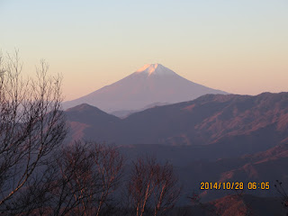
After taking several pictures at the summit, we walked along the ridge. It was a wonderful ridge hike. We could see Mt. Fuji clearly all the way along the ridge.
We could see many peaks of mountains together with Mt. Fuji from far distance. There were autumn colors covering the lower peaks of closer mountains.
From the summit of Mount Kumotori to Mt. Nanatsuishi, we took a break and enjoyed coffee and snacks which I brought. It was nice that I had accompany person.
Along the “Kamosawa Route”I walked for the two days, there are several water places including the one at the Lodge Kumotori. Mr. K had a nice set of cooker and he could boil water with them. It must be nice to have such a set to cook ramen during the hiking.
When we arrid at Lodge Nanatsuishi, he used the bio-toilet there. He said the toilet was clean and nice but I did not use it. (It was not necessary for me.)
When we came down close to the forest road, Mr. K offered a ride to Okutama Station by his car. Oh, it was very kind of him. Then I do not worry about the bus timetable.
We arrived at the municipal parking lot, it was 9:50. We passed the bus-stop at about 10 am. We arrived at Okutama Station at 10:30, therefore, I coult take the 10:37 train bound for Oume Station.
I changed train at Oume Station to Chuo Kaisoku Train. So, I could go to Ofuna Station only changing trains two times.
It was still before 3 pm when I arrived at Ofuna Station. So, I went to Taya Hot Spring by bus. I enjoyed the local hot spring and went home before 6 pm.
It was a nice hike, knowing a kind youth at the lodge on the mountain.
------------------------------------------------------------------------------
分類:登山、日本、関東、登山、日本百名山
登山地:雲取山(くもとりやま)東京都・埼玉県・山梨県の境界にある標高2,017.09mの山
登山日:2014年10月28日(火)晴れ
下山コース:雲取山荘~雲取山頂上~七ツ石山~町営駐車場(下り時間3時間50分)
JR奥多摩~立川~武蔵小杉~大船
同行者:Mr. K(宇都宮在住)
朝4時に山小屋のすべての部屋の電灯が点いた。手洗い・洗面のために外へ出ると星がまだ出ていて雲取山方面の頭上にはオリオン座がくっきりと見えた。
三峰方面には北斗七星の大きな柄杓が立っていた。水場の水は相変わらず勢いよく流れているが、洗面器の水は凍っていた。
使った布団はたたまなくてよいと言われているので支度は簡単に終わった。Kさんは鴨沢の丹波村営駐車場に車を停めているので下山ルートは同じだ。彼が前日歩いた雲取山頂も登り返すというので同行することにした。
食堂前に4:45に行き、午前のバスの時刻表を確認すると鴨沢バス停は10:25で、次は13:55と3時間も間が空くので、このバスに乗ることにした。
4:50から朝食がOKとなり、前夜に続き我々がトップに入った。また、隣の席は前日同様、耳の不自由なカップルが座った。
朝食はメインが焼鮭と生卵でふりかけやうめぼしが自由にとれるのでおかわりがしやすい。今回はごはんのお代わりをした。
チェックアウトは6時前。外の寒暖計は零度を示していた。昨夜見えた下界の光は雲海の下で見えない。雲取山荘の入り口で認証写真を撮ってからいよいよ雲取山頂を目指して登頂を始めた。
前夜、布団に入って体が温まったとき、喘息の症状が現れたが、この上り坂でも若干現れた。登山コースは大菩薩嶺の時と似ているが、雲取山荘から頂上へのアクセスのほうが近い。
約30分で山頂に到達した。山小屋の朝食で隣り合わせた耳の不住なカップルと、前夜テントで止まった二人組の男性のハイカーが先客で、頂上からのすばらしい展望の写真撮影をしていた。
雲取山から七ツ石山までの稜線は、ちょうど大菩薩嶺から大菩薩峠までの稜線同様、右手中央に富士山が見え、みわたすかぎり山々のみが見える絶景だ。
手前の山々の紅葉もじつに美しい。上澤さんと登山の話をしながらの山行は実に楽しい。途中、七ツ石山山頂ともう一か所で休憩し、朝山小屋でもらった湯でインスタントコーヒー、およびロッテのダイスタイプのチョコレートおよび山崎パンの薄皮饅頭パンを分け合った。
七ツ石山から下った七ツ石山荘で上澤さんはバイオトイレを利用した。実に清潔で感じが良いというが、私は朝食後、雲取山荘で使ったのでここでは利用しなかった。
雲取の鴨沢ルートでは雲取山荘はもちろん、七ツ石山荘のほか、登山道わきにも2,3か所水場があり、水は豊富だ。私は今回、900ccの熱湯ボトルと500ccのぬるい桑の葉茶だけで十分だった。
Kさんを待った時間はたぶん5分程度だったと思うが長く感じられ、下山を急いだ。下山途中で何組も登ってくるハイカーとすれちがった。
林道が見えるほど下ったとき、Kさんが奥多摩駅まで送ってくれると言い出してくれたのでバスには乗らず、ご厚意に甘えることにした。
丹波村営駐車場には9時50分に到着し、バス停前は10時ごろ通過、奥多摩駅には10時30分ごろ到着できた。
おかげで青梅行き10:37のJRに乗ることができ、青梅からは東京行きの中央快速に乗り換えたので、乗り換えは2回で済み、東海道下りは13:52に乗れた。
午後3時前に大船に戻れたので、大船駅からバスで田谷温泉へ行き、しっかり温泉を楽しんだ。山登りの後の温泉は格別である。
I like hiking very much. I used to go hiking with a Korean hiking club named “AhToSan.” This blog introduces mostly my hiking activities in Korea and Japan, and Sydney in Australia. As of January 2020, I live in Sydney suburb. I go Blue Mountains and bush walk in Sydney area. 私は2003年から2014年まで韓国の大田(テジョン)に住んだ日本人である。11年間、週末は主に「アトサン山岳会」に参加した。14年4月に帰国したが、2020年以降はおもにシドニーで暮らし、時折、日本へ帰国する程度である。したがって最近の記事はSR(Sydney Report)としてブルーマウンテンのトレッキングを中心に書いている。
About pictures/当ブログ内の写真について/당 블로그내의 사진에 대해서
Most of the pictures in this blog are taken by my camera, yet some of them were downloaded from the website of the hiking club. If you click any pictures, they become the original size.
当ブログ内の写真の大部分は筆者のカメラで撮影したものですが、一部、山岳会の共有写真からダウンロードしたものを含みます。すべて、各写真をクリックすれば、元のサイズに拡大します。
당 블로그내 사진의 대부분은 필자의 카메라로 촬영한 것입니다만 일부 산악회 공유 사진으로부터 다운한 것도 포함합니다. 모두 각 사진을 클릭하면, 원래 사이즈에 확대합니다.
当ブログ内の写真の大部分は筆者のカメラで撮影したものですが、一部、山岳会の共有写真からダウンロードしたものを含みます。すべて、各写真をクリックすれば、元のサイズに拡大します。
당 블로그내 사진의 대부분은 필자의 카메라로 촬영한 것입니다만 일부 산악회 공유 사진으로부터 다운한 것도 포함합니다. 모두 각 사진을 클릭하면, 원래 사이즈에 확대합니다.


0 件のコメント:
コメントを投稿