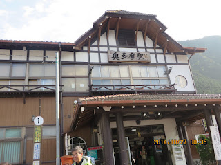
Mountain: Kumotoriyama (雲取山 2,017m) in Tokyo (東京都), Saitama Prefecture (埼玉県) and Yamanashi Prefecture (山梨県), One of One Hundred Famous Mountains in Japan (日本百名山)
Date: October 27(Mon) – 28 (Tue)
Access: Ofuna – Musashikosugi – Tachikawa – Okutama (JR) – Kamosawa (Bus) [5.5 hours]
Hiking Course: Kamosawa Bus Stop – Kosode Norikoe – Mt. Nanatsuishi – Lodge Kumotori (5.5 hours)
Partner: None,
Since I got exited for this hike, I woke up at 2:30 am It was a bit early, but I prepared for the hike and took 5:45 train bound for Chiba.
I changed from Sobu Line to Nanbu Line at Musashikosugi. I went to Tachikawa from there.
I changed trains again to Oume Line at Tachikawa, and went to the terminal; Oume at 8:34 am.
Since the bus left at 8:37, I was in a hurry. It was full but I could take the last seat on the bus.
The bus went on to Lake Okutama, and it arrived at Kamosawa Bus Stop at 9:30 am, almost one hour later.
There were 7 or 8 passengers who got off at this bus-stop including myself. They all seemed to be heading for Mt. Kumotori.
The entrance of the trail was above the bus stop. I walked along the paved road according to the guideposts, and there was an warning “Caution to Bears!”
There must be thousands of bears in Honshu Island in Japan. I put small bells on my bag.
There was a gentle slope toward the mountain peak. The trail went through the woods of evergreen and deciduous trees.
It seemed that were more evergreen trees than deciduous trees. It was a bit dark under evergreen trees, and blight through deciduous woods.
One reason is autumn color. Deciduous trees turned red or yellow, while evergreen trees remained as dark green.
After walking for 2 hours, I came to the fork point for Nanatsuishi Mountain and “Roundabout trail” of it. I took the roundabout trail to the peak.
I felt hot while walking because I was wearing summer trousers. When I reached at the end of the roundabout trail, it became foggy and I went into the cloud.
I saw a small lodge with zinc roofing but it was not the Kumotori Lodge. It was “Okutama-Yamanoie” which was operated by Okutama-cho (town).
It seemed that I came completely into the cloud. There was no sunshine, and dark. I felt cold this time. So, I hurried my way to the lodge “Kumotori Lodge.”
Then I came to the folk point again.The guide post showed that the upper trail was for Mt. Kumotori/Mitsumine, ad the lower trail was to Kumotori Lodge. So, I took the lower trail.
After a while, I kept walking along the lower trail, actually it was a roundabout, I saw a deer with graceful horns. Seeing upon me, it turned back and walked away. I chased him, but soon it disappeared.
For about one hour I walked from the fork point, finally I saw “Kumotori Lodge.” It was 4:10 pm when I arrived at the lodge.
There was a middle-aged man sitting at the front desk. I paid 7800 yen for a night with two meals. My roommate was a young man named Yoshiyuki Kamisawa who works at a automobile related company in Utsunomiya. He is quite friendly and we talked about hiking.
There was a relief of Juji Tanabe who introduced Okuchichibu mountains to the world about hundred years ago. (Jūji Tanabe (田部 重治 Tanabe Jūji, August 4, 1884 - September 22, 1972) was a Japanese literature scholar, teacher, and mountain climber.
The dinner time was at 6 pm. We went to the dining room together. He had a good appetite and required helping with “large size” of rice.
Next to our table, a couple who were talking each other with sign language.
Our room for sleeping was rather spacious, but there was only a filament lamp. Mr. Kamisawa took his LED “lantern” which was much brighter, from his bag.
They turned off the room lamp at 8:30 pm. The rest-room was apart from main building. It was a flush toilet, but Japanese style.
When I went out for the toilet at night I could see the beautiful sky with full of shining stars.
----------------------------------------------------------------------------------------------------------------
分類:登山、日本、関東、登山、日本百名山
登山地:雲取山(くもとりやま)東京都・埼玉県・山梨県の境界にある標高2,017.09mの山
登山日:2014円10月27日(月)~28日(火)
交通アクセス:大船~武蔵小杉~立川(JR)~奥多摩(JR)、奥多摩~鴨沢(バス)
登山コース:鴨沢バス停〜小袖乗越〜七ツ石山〜雲取山。登り5時間30分
宿泊:雲取山荘
同行者:なし。
交通のアクセスは大船~武蔵小杉~立川~奥多摩で、奥多摩からはバスで鴨沢だ。朝2時半に目が覚めた。
大船発5時45分の千葉行きに乗車、武蔵小杉で南武線に乗り換えたが、地下通路をかなりあるかねならない。
予定の6時24分発の南武線には余裕で間に合った。下りは席も空いていて快適だった。南武線で立川まで行き、立川で青梅線に乗り換えて青梅へ行き、終点の青梅でさらに奥多摩へ向かった。
終点の奥多摩には8時34分に到着。バスは8:37発でほぼ満席。私は幸いにも最後の座席を確保した。
バスは奥多摩湖の周囲を行き、鴨沢には9時半に到着した。ここで下車したのは私を含めて7~8人でみな雲取山登山者とみえる。バス停でバスを降りてふと前の民家の軒下をみると巨大なスズメ蜂のの巣がブル下がっているのに驚いた。
登山道入口へはバス停後ろの階段を上り、舗装道を道なりに進むと左手に入る道のところに標識があり、さらに進むと舗装道路の左にコンクリの階段の登り口が見えてきた。
入口の標識の下には「熊に注意」の警告があり、不安になって熊よけの鈴をつけた。登山路にそってしばらく舗装道路を進むと、丹波山温泉のめこい湯の看板が見えてきた。ちなみに「丹波山」は「たばやま」と読むらしい。この温泉は単純硫黄泉ということで、下山後にはいるとよいだろう。
本格的な登山道に入ってからは緩やかな上り道が続き、それが常緑樹と広葉樹の林が交互に続いている。足元を見るとウラシマソウの真っ赤な実があった。
どちらかといえば暗い常緑樹の林が長く、やがて明るい広葉樹の林が一瞬あらわれるといったふうである。
広葉樹はみごとに紅葉していている。また、木立の間からは谷の反対側の山の紅葉がよく見える。
2時間ほど進むと七ツ石山への道とブナ坂の巻き道との分岐点に出た。私はブナ坂の巻き道を選択した。天気は晴れで上り坂では汗をかく。
冬用のズボンでは暑く感じられる。巻き道の終わるころ、雲が出てきて、高度があがるにつれその雲のなかに入る風だ。
ようやくトタン屋根の山小屋が見えてきたがこれは町営の奥多摩山の家で目的の雲取山荘ではない。
このあたりで完全に雲の中にはいったようで日が陰り、気温も下がり、暗くなった。それでも半袖シャツのまま、先を急いだ。
改めて尾根道と巻き道の分岐点が現れた。尾根道のほうは雲取山・三峰とあり、巻き道のほうは雲取山荘となっていたので、後者を選択した。
巻き道をしばらく進むと立派な角を持った鹿が現れた。こちらを見てからすぐ踵を返して登山道を歩いて行った。私は追う形で巻き道を進んだ。
この巻き道はかなり長く、途中、崖が崩れたような悪路もあった。この付近で鹿を見失った。また、「ニホンシカ捕獲の実施」という大きな看板を見た。なんとニホンシカの食害被害を減らすため、ライフル銃および罠によるニホンシカ捕獲作戦を実施するという通知だった。
分岐点から約1時間以上進んだ先にようやく雲取山荘が見えてきた。また、山荘の近くには奥秩父の山々や日本アルプスを世間に知らしめた登山家で英文学者の田辺重治(たなべじゅうじ)のレリーフがあった。
雲取山荘についた時間は4時10分だった。受け付けは頑固そうなおやじで料金は1泊2食で7800円。部屋は2-7で相部屋だった。
かなり広い畳の部屋で中央に練炭の炬燵。先客の若者は宇都宮から来た自動車関連の企業につとめる上澤義之さんだった。
なかなかフレンドリーな青年で、話しかけてくるので、最初から最後までついにパソコンは出さず、話に応じた。
食事は6時からで1番に食堂に入り夕食を食べた。彼はご飯を大盛りでお替わりをした。食欲は健康のあかしだろう。となりは耳の不自由なカップルだった。
夕食後部屋に戻ったが、広い部屋に小さな電灯1個の証明だったので、彼は白色LEDランタンを取り出して使った。
消灯は8時30分ごろ、突然部屋の照明が消えた。トイレは小屋の前左手の別棟で、トイレットペーパーもいっしょに流すタイプの水洗和式トイレ。
水場は小屋の前の右手で飲み水が豪勢に流れっぱなし方式。雲取山荘0494-23-3338 1泊2食で7,800円
I like hiking very much. I used to go hiking with a Korean hiking club named “AhToSan.” This blog introduces mostly my hiking activities in Korea and Japan, and Sydney in Australia. As of January 2020, I live in Sydney suburb. I go Blue Mountains and bush walk in Sydney area. 私は2003年から2014年まで韓国の大田(テジョン)に住んだ日本人である。11年間、週末は主に「アトサン山岳会」に参加した。14年4月に帰国したが、2020年以降はおもにシドニーで暮らし、時折、日本へ帰国する程度である。したがって最近の記事はSR(Sydney Report)としてブルーマウンテンのトレッキングを中心に書いている。
About pictures/当ブログ内の写真について/당 블로그내의 사진에 대해서
Most of the pictures in this blog are taken by my camera, yet some of them were downloaded from the website of the hiking club. If you click any pictures, they become the original size.
当ブログ内の写真の大部分は筆者のカメラで撮影したものですが、一部、山岳会の共有写真からダウンロードしたものを含みます。すべて、各写真をクリックすれば、元のサイズに拡大します。
당 블로그내 사진의 대부분은 필자의 카메라로 촬영한 것입니다만 일부 산악회 공유 사진으로부터 다운한 것도 포함합니다. 모두 각 사진을 클릭하면, 원래 사이즈에 확대합니다.
当ブログ内の写真の大部分は筆者のカメラで撮影したものですが、一部、山岳会の共有写真からダウンロードしたものを含みます。すべて、各写真をクリックすれば、元のサイズに拡大します。
당 블로그내 사진의 대부분은 필자의 카메라로 촬영한 것입니다만 일부 산악회 공유 사진으로부터 다운한 것도 포함합니다. 모두 각 사진을 클릭하면, 원래 사이즈에 확대합니다.


0 件のコメント:
コメントを投稿