"A Beatles Song & Total Lunar Eclipse in Sydney
On the night of May 26th, I participated in the ukulele concert held at the nearby Dougherty Community Center once a month. This month's theme was "Beatlemania! BUSK, The Beatles Night" and I requested "When I am Sixty-Four". I used to sing this song as "a monthly song" at the Kamakura English Club in late1970s.
“When I'm Sixty-Four" by The Beatles
When I get older losing my hair
Many years from now
Will you still be sending me a valentine
Birthday greetings, bottle of wine?
If I'd been out till quarter to three
Would you lock the door?
Will you still need me, will you still feed me
When I'm sixty-four?
You'll be older too
And if you say the word
I could stay with you
I could be handy, mending a fuse
When your lights have gone
You can knit a sweater by the fireside
Sunday mornings go for a ride
Doing the garden, digging the weeds
Who could ask for more?
Will you still need me, will you still feed me
When I'm sixty-four?
Every summer we can rent a cottage in the Isle of Wight
If it's not too dear
We shall scrimp and save
Grandchildren on your knee
Vera, Chuck and Dave
Send me a postcard, drop me a line
Stating point of view
Indicate precisely what you mean to say
Yours sincerely, wasting away
Give me your answer, fill in a form
Mine forevermore
Will you still need me, will you still feed me
When I'm sixty-four?
Ho!
Steve, the organizer, nominated me to sing, but I don't have the courage or skill to sing while playing the ukulele. I asked an advanced player to sing, and I sang in a soft voice and played only the chords that I could play.

The melody of "When I am Sixty-Four" is light, and I thought the lyrics were in the distant future for me at that time, but I will be 74 years old this year!

When I returned to the share house with a melancholic feeling, there was the super moon above our room where the lunar eclipse had already begun.

My wife has a backache, so it is difficult to look up at the sky. However, this time was 20:30, and the moon was still above the east. Both of us have never experienced such a clear lunar eclipse.

We talked to the neighbors of the share house and watched this sky show together. The "total lunar eclipse", in which the moon completely falls in the shadow of the earth, lasted for about 20 minutes from around 21:30, and we enjoyed the mystery of universe while remembering the creator who created this beautiful cosmic order.
"Sydney Gulf Trekking Part II"
I introduced 5 sections of Sydney Gulf trekking in SR # 34. This time, I will introduce the following two sections.
"# 6 From Manly Beach to Dobroyd Head"
Date and time: April 30, 2:00 pm to 4:30 pm
Departure point: Manley beach, ferry terminal
Destination: Dobroyd Head in North Harbor
In the morning, there was a guided bushwalk sponsored by the City of Willoughby, and I walked through Chatswood's Blue Gum Reserve from 9:30 to 12:00.

After returning to the share house and having lunch, I immediately went to the bus stop in front of the station and took the # 144 bus to Manly. The bus departed at 13:00 and arrived at Manly at 13; 50.
My bushwalk mentor, Chang, arrived at 14:00 on a ferry from the Olympic Park. It takes him two hours from the Olympic Park.
Manly Ferry Wharf is quite large. A sales clerk was handing out ice cream tasting samples. There was a small art gallery on the outskirts of the beach in the direction of trekking and there was a functionally designed toilet with shower rooms.
There was a sign of "Manly-Bondi Walk" next to the art gallery, and it was a course that walked alternately on the road and the coastal promenade.
There are many trail runners on the coast. Also, there are many luxurious apartments. There was a place where a huge rock and a tree were entwined on the way, and a thick rope was hanging from the branch of the tree, and it was possible to play Tarzan.
Chang got on the rope. He has a child-mind.

We walked for about two hours and took a break on the beach with the "No Nude" sign. I took out a tapper containing persimmons that I got from Chan last time and put purple potatoes in it and we shared them. Chang gave me hard persimmons this time. They are astringent persimmons that turn into sweet persimmons when ripe.
Australian magpies and a water dragon are begging for the potato skins we throw away.

For some reason, the facility connecting this coast and the promenade was permanently struck by crossbars, making it impassable, so we rowed bushes without roads and went out to the promenade.

Closely ahead of this beach was Dobroyd Head, the final destination of the walk, where there was a large field for children to play. Here, Chang asked the residents for the location of the nearest bus stop and we boarded from the bus stop in front of the tennis court.
We got off at the town of the bus route between Manley and Chatswood. I broke up here with Chang, took the # 170X express bus to the City to Wynyard, and took the train back to Chatswood. During this time the sun set. I have finished a long trekking day.
The daily walking distance was 16.6km, the number of steps was 27,173, and the number of floors was 37.
"# 7 From Spit to Dobroyd Head"
Date and time: May 14, 2:00 pm to 4:30 pm
Departure: Spit West Reserve
Destination: Dobroyd Head in North Harbor
I took # 144 bus from the bus stop in front of Chatswood station. I told the driver to let me off at Spit West Reserve. I arrived at 13:30 in about 45 minutes.
It was very windy, but I ate lunch on a bench with a table and waited for Chang. He arrived at 2 o'clock.
We started trekking from the reserve across the Spit Bridge.

This bridge opens several times a day for tall vessels. Just at that time, I heard the horn, then, the bridge was gradually opening, and the ships passed by.
[When the bridge is open, 橋が開いているとき、다리가 열려있을 때]
On the trekking course, rocky areas and sandpits appear alternately. We went off the well-maintained trekking course and took a break along the rocks where we could see the opposite bank.

I shared my usual roasted sweet potato with him. He gave me two fine persimmons following the last time. I was told that I should wait for a few weeks because it is not ripe yet.
After passing this rocky area, we climbed the rocky area and entered the promenade of the regular route. We continued trekking for about two hours and arrived at Dobroyd Head, the same destination as last time.

As before, we crossed a large field and headed for the bus stop beyond the tennis court. However, this time we headed to Manley Beach in the opposite direction of the last time.
This judgment is correct. There are # 144 buses from Manley Beach to Chatswood every 10 minutes, and Chang took a ferry to the Olympic Park. I sent a photo of the Spit Bridge by Kakao-Talk and he sent me a photo of the Harbor Bridge at sunset.
I arrived at the share house near 6 o'clock.
The walking distance on that day was 14.9km, the number of steps was 24,595, and the number of floors was 45.
"Coxs Cave Truck in Mount Victoria"
Dates: May 17 for independent preview, May 29 with Saturday Hikers
I went halfway through the Coxs Cave Circuit Track two years ago when I walked alone on some of Mount Victoria's tracks.
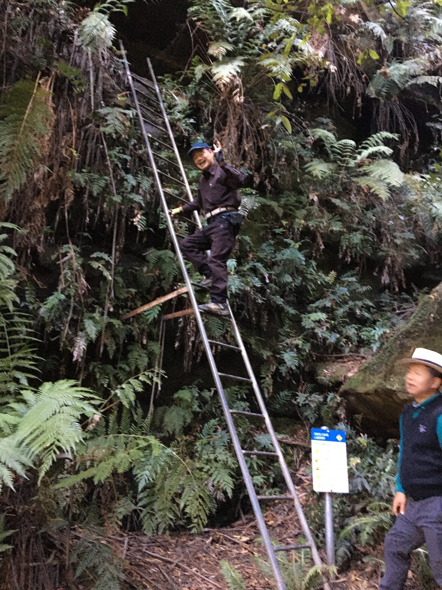
However, at that time I went to the Fairy Bower Track, which was blocked at the fork, and for me this circuit course was an unfinished course. Last month, I saw Miss K uploaded a photo of the iron ladder in front of the cave on Facebook, and I was interested in it, so I went there for the first time in two years.
Mount Piddington, where the track-head of this circuit is located, is about 2 km from Mount Victoria Station. Last July, I came to this place after walking along the Little Zigzag Circuit in Pulpit Rock with my fellow "Saturday Hikers".

Between Victoria Station and Mount Pidington is One Three Hill (1,111m above sea level), the highest altitude in the Blue Mountains area. This time, we headed for Mount Pidington, saw the magnificent scenery at this observatory, and then walked on the Cox Cave circuit track. The companions are Isaac and Rev. Kim. This time, we accompanied a Korean group of four, going in the same direction to Coxs Cave.

There is a car-accessible paved road to Mount Pidington, with a roundabout around the observatory.
We climb the observatory from the One Three Hill side and the truck entrance is on the other side. When we go down a few tens of meters from the entrance, there are arrows in both left and right directions, and down the left side, there is a waterfall hidden in a large rock.
Below this waterfall is a junction with the direction of Fairy Bower. The wooden bridge to Fairy Bower is decaying and is closed to traffic (it was the same two years ago).
If you turn right at the junction, you will find another fork further down the valley, and there is no sign here, but if you climb a little uphill on the right side, you will see the iron ladder and it says "Coxs Cave". There is a good sign.

When we put our backpacks at this sign and climb the ladder, there is a trail that continues up, and Cox Cave is up the sloping mud slope. There is a small board with the words "Cox Cave" on the wall of the cave, and the eaves-shaped rock on the left side is the observatory. After that, there was a dead end, and after enjoying the view, we turned back.

We returned to the ladder and climbed a steep truck for about 30 minutes with backpacks. Then we returned to the left and right branch point. The time we returned to Mount Pidington's observatory was 12:40, so it's just a two-hour trek. The group of four who accompanied so far, continued trekking toward Pulpit Rock.
I had lunch at Mount Piddington's table with my "Saturday Hikers" buddies.
I had a KEC (Kamakura English Association) zoom meeting scheduled for this day, so I broke up with my friends and took the train at Victoria Station at 14:18 to return.

The two who accompanied me so far continued trekking in the direction of Palpit Rock, like the quartet.

My walking distance on this day was 11.2km, the number of steps was 17,984, and the number of floors was 49, which was light for trekking in the Blue Mountains.
-------------------------------------------------------------------------
SR35号「ビートルズの歌とシドニーの皆既月食」「シドニー湾岸トレッキング パートⅡ」「マウント・ビクトリアのコックス洞窟トラック」 「ビートルズの歌とシドニーの皆既月食」
5月26日の夜、毎月1回、近所のドカティ・コミュニティ・センターで開催されるウクレレ演奏会に参加した。今月のテーマは「ビートル・マニア!バスク、ビートルズの夜」で、私も「When I am Sixty-Four」をリクエストした。この歌は当時(1970年代)、鎌倉英語会で「月間練習曲」として毎週歌ったものだ。 歌詞は以下である。
「私が64歳になっても」ザ・ビートルズ
私が年をとって、髪の毛も薄くなって
ずっと先のことだよ
まだバレンタインの贈り物をくれる?
誕生日のお祝いは?
ボトルのワインは?
私が2時45分まで家に戻らなければ
ドアに鍵をかけてしまう?
まだ私を必要だと思う?
まだ養ってくれる?
私が64になっても
あなたも年をとるね
ああ、もしその言葉をいったのなら
私はあなたと一緒にいられる
ヒューズを取り替えるのに役立つかも
君の明かりが消えた時
暖炉のそばでセーターを編んでもいいし
日曜の朝はドライブに行って
庭を作ったり、草をむしったり
これ以上望む人がいる?
まだ私を必要とする?私を食べさせてくれる?
私が64になっても
夏には毎年コテージを借りる
ワイト島で
そんなに高くなければね
コツコツ貯めよう
孫をひざの上に乗せて
ヴェラとチャックとデイブだよ
ハガキを送って
一言添えて
見解を書いて
何がいいたいのかは正確明瞭に
心を込めて、なんていいから
答えてね
ご記入ください
永久に私のものになってね
私をまだ必要かな?
まだ養ってくれるかな?
私が64になっても?
主催者のスティーブに歌うよう指名されたが、ウクレレを演奏しながら歌うだけの度胸も技量もない。上級者に歌ってもらい、私は小さい声で歌いつつ、演奏できるコードのみを弾いた。

「When I am Sixty-Four」のメロディは軽快で、歌詞は当時の私にとって遠い将来のことだと思っていたが、なんと今年の誕生日には74歳になる。
メランコリックな気持ちでシェアハウスに戻ると、我々の部屋の上にすでに月食が始まったスーパームーンがかかっていた。

妻は腰痛のため、天空を仰ぎ見るのが難しい。しかし、この時刻は20:30で、月はまだ東の上空である。これだけクリアな月食は二人とも初体験である。

シェアハウスの隣人にも声をかけて三人でこの天空ショーを鑑賞した。月が完全に地球の影に入る「皆既月食」は21:30ごろから約20分間続き、この美しい宇宙の秩序を創造された創造主を覚えつつその神秘を堪能した。

「シドニー湾岸トレッキング パートⅡ」
SR#34号でシドニー湾岸トレッキングの5区間を紹介した。今回はこれに続く2区間を紹介する。
「#6 マンリー・ビーチからドブロイド・ヘッドへ」
日時:4月30日午後2時~午後4時半
出発地:マンレービーチ、フェリー乗り場
目的地:ノースハーバーのドブロイド・ヘッド
この日、午前中はウィロビー市主催のガイド付きブッシュウォークがあり、9時半から12時まで、チャッツウッドのブルーガムリザーブを歩いた。

いったんシェアハウスに戻って昼食後、すぐに駅前バス停へ行き、#144バスでマンリーへ向かった。13時発のバスで、マンリーには13;50に到着した。
私のブッシュウォークのメンターのチャンはオリンピック公園からフェリーに乗って14:00に到着した。オリンピック公園から2時間もかかるという。
マンリーのフェリー埠頭はかなり大きい。アイスクリームの試食サンプルを配っていた。進行方向の浜のはずれに小さなアートギャラリーがあり、シャワー室を兼ねた、機能的なデザインのトイレがあった。

アートギャラリーの横に「マンリー~ボンダイ・ウォーク」のサインがあり、道路と海岸の遊歩道を交互に歩くコースになっていた。
海岸は男女のトレイルランナーが多い。また、豪華なアパートが多い。途中に巨大な岩と木が絡んだ場所があり、その木の枝からは太いロープがさがっていて、ターザン遊びができるようになっていた。
チャンがそのロープに乗った。彼は童心がある。
2時間ほど歩いて「ヌード禁止」の看板のある海岸で休憩した。前回チャンにもらった柿が入っていたタッパに紫芋を入れたものを出して食べた。チャンは固い柿をくれた。これは熟すると甘柿になる渋柿である。

オーストラリア・カササギとウォータードラゴンが我々の捨てる芋の皮をねだって寄ってきた。

この海岸と遊歩道を結ぶ施設がなぜか横木が永久的に打ってあり、通行できないようになっていたため、道のない藪を藪漕ぎして遊歩道に出た。
この浜のすぐ先が今回の最終場所のドブロイド・ヘッドで、子供たちが遊ぶ広いフィールドがあった。ここでチャンが住民に最寄りのバス停の場所を尋ね、テニス場前のバス停から乗車した。

マンレー-チャッツウッド間のバスルートの町で下車してチャンとは別れ、#170Xというシティ/ウィンヤード行の急行バスでWynyardへ出て、鉄道でチャッツウッドに戻った。この間に日没。長いトレッキング・デーを終えた。
一日の歩行距離は16.6km、歩数は27,173、階数は37階だった。
「#7 スピットからドブロイド・ヘッドへ」
日時:5月14日午後2時~午後4時半
出発地:スピット・ウエスト・リザーブ
目的地:ノースハーバーのドブロイド・ヘッド
チャッツウッド駅前のバス停から#144番バスに乗車。運転手にスピット・ウエスト・リザーブで下してくれと告げた。約45分で13:30に到着した。 非常に風が強かったが、テーブル付きベンチで弁当を食べてチャンを待った。チャンは2時に到着した。
我々はリザーブからスピット・ブリッジを渡ってトレッキングを開始した。

この橋は日に何度か開き、背の高い船舶を通す。ちょうどその時間になり、警笛がなり、橋が開き、船が通るところを目撃した。
[When the bridge is open, 橋が開いているとき、다리가 열려있을 때]
トレッキングコースは岩場と砂場が交互に出てくる。整備されたトレッキングを外れて、岩場を伝って対岸の見える場所で休憩した。

、 私はいつもの焼き芋をシェア。彼は前回に続いて立派な柿を2個くれた。まだ熟していないので数週間、待つがよいと言われた。
この岩場を過ぎてから、岩場を上り正規のルートの遊歩道に入った。約2時間、トレッキングを続け、前回の目的地のドブロイド・ヘッドに到着した。
これで、マンレービーチからスピットまでのルートを歩いたことになる。
我々は前回同様、広いグラントを横切り、テニスコートの先のバス停に向かった。ただし、今回は前回と反対方向のマンレービーチへ向かった。
この判断は正解。マンレービーチからチャッツウッド行の144番バスは10分おきにあるし、チャンはフェリーでオリンピック公園へ向かった。
私はカカオトークでスピット・ブリッジの写真を送り、彼は日没のハーバーブリッジの写真を送ってきた。
シェアハウスに着いたのは6時近かった。この日の歩行距離は14.9km、歩数は24,595、階数は45階だった。
「マウント・ビクトリアのコックス洞窟トラック」
実行日:単独下見は5月17日、本番は5月29日
コックス・ケーブ・トラックは一昨年、マウント・ビクトリアのいくつかのトラックを一人で歩いた時、途中まで行ったが、分岐点で当時閉鎖され、現在も封鎖中のフェアリ・バウア・トラックの方に行ってしまい、私としては未完のコースだった。
先月、フェイスブックでKさんが、この洞窟の手前に設置された鉄製の梯子の写真をアップロードされたのをみて、関心を持ち、2年ぶりに行ってみた。
このサーキットのトラックヘッドがあるマウント・ピディングトンは、マウント・ビクトリア駅から約2kmはなれている。昨年7月、私は土曜ハイカーズの仲間とともに、パルピットロックのリトル・ジグザグ・サーキットを歩いたのちにこの場所に来た。
ビクトリア駅とマウント・ピディングトンの間には、ブルーマウンテン地区で最も標高の高いワン・スリーヒル(海抜1111m)がある。

今回はこのマウント・ピディングトンを目指し、この展望台で雄大な風景を見たあと、コックスケーブのサーキットトラックを歩いた。

同行者は、アイザックとキム牧師。今回は、同じ方向へ行く韓国人の4人組と洞窟まで同行した。
マウント・ピディングトンまでは車でアクセス可能な舗装道路で、展望台のまわりはロータリーになっている・
ワン・スリーヒル側から展望台に上り、その反対側にトラックの入り口がある。入り口から数十メートル下ると左右両方向に矢印があり、左側を下ると、大きな岩に隠れた滝がある。
この滝の下にフェアリ・バウア方面との分岐点がある。フェアリ・バウア方面へかかる木橋が朽ちていてそのため、こちらは通行止めになっている(2年前も同じ状態だった)。
分岐点を右折すると、さらに渓谷をくだったところにもう一度分岐点があり、ここには標識がないが、右側の上り坂を少しのぼると鉄製の梯子がみえて「コックスケーブ」と書かれた立派な標識がある。
この標識のところにリュックを置いて、梯子を上ると、さらに上につづく道があり、傾斜のある泥の坂を上り切ったところがコックスケーブだ。
洞窟の壁に「コックスケーブ」と書かれた板があり、その左側のひさし状の岩が展望台となる。その先は行き止まりで、展望を楽しんだうえで引き返した。
梯子のところに戻り、リュックをかついで30分も登れば、左右に分かれた分岐点にもどる。
マウント・ピディングトンの展望台に戻った時刻は12:40だったのでちょうど2時間のトレッキングである。ここまで同行した4人組はさらにパルピットロック方面へトレッキングを続けた。
私は土曜ハイカーズの仲間と、マウント・ピディングトンのテーブルでランチタイムにした。
私はこの日、KEC(鎌倉英語会)のズーム・ミーティングの予定があるため、仲間と別れ、ビクトリア駅14:18の列車で復路についた。
ここまで私と同行した二人は、4人組と同様、パルピットロック方面へトレッキングを続けた。
私のこの日の歩行距離は11.2km、歩数は17,984歩、階数は49階で、ブルーマウンテンの山行としては軽いものだった。
0 件のコメント:
コメントを投稿