I like hiking very much. I used to go hiking with a Korean hiking club named “AhToSan.” This blog introduces mostly my hiking activities in Korea and Japan, and Sydney in Australia. As of January 2020, I live in Sydney suburb. I go Blue Mountains and bush walk in Sydney area. 私は2003年から2014年まで韓国の大田(テジョン)に住んだ日本人である。11年間、週末は主に「アトサン山岳会」に参加した。14年4月に帰国したが、2020年以降はおもにシドニーで暮らし、時折、日本へ帰国する程度である。したがって最近の記事はSR(Sydney Report)としてブルーマウンテンのトレッキングを中心に書いている。
About pictures/当ブログ内の写真について/당 블로그내의 사진에 대해서
Most of the pictures in this blog are taken by my camera, yet some of them were downloaded from the website of the hiking club. If you click any pictures, they become the original size.
当ブログ内の写真の大部分は筆者のカメラで撮影したものですが、一部、山岳会の共有写真からダウンロードしたものを含みます。すべて、各写真をクリックすれば、元のサイズに拡大します。
당 블로그내 사진의 대부분은 필자의 카메라로 촬영한 것입니다만 일부 산악회 공유 사진으로부터 다운한 것도 포함합니다. 모두 각 사진을 클릭하면, 원래 사이즈에 확대합니다.
当ブログ内の写真の大部分は筆者のカメラで撮影したものですが、一部、山岳会の共有写真からダウンロードしたものを含みます。すべて、各写真をクリックすれば、元のサイズに拡大します。
당 블로그내 사진의 대부분은 필자의 카메라로 촬영한 것입니다만 일부 산악회 공유 사진으로부터 다운한 것도 포함합니다. 모두 각 사진을 클릭하면, 원래 사이즈에 확대합니다.
2012年7月13日金曜日
120630 Mt. Cheonghwa(青華山청화산) and Mt. Johang(鳥項山조항산) in Chunbuk (忠北충북)
Hiking Date: June 30, 2012 (Sat) Rain
Destination (mountain): Mt. Cheonghwasan & Mt. Johangsan, Gwisan, Chungbuk Province
Hiking course: Neuljae – Cheonghwasan – Gatbawuijae – Johangsan – Wuisang Resevoir – Yongsong –Okyangdong (13 km, 6 hours)
Partner: 23 AhToSan members
It was raining all day. Since the destination was rather close to Daejeon, we left South Gate Bus Top at 7 am.
[A map of Gwisan area showing the trails, 登山路を示す槐山地区の地図、등산로를 나타내는 괴산지구의 지도]
We arrived at Neuljae where we began hiking at 9:15. There were no other hikers, but only AhToSan members.
[The chartered bus arrived at the destination, 目的地到着、산행지 도착]
There was a sign which said “Watershed” of Nak-dong-gang and Han-gang, two big rivers in Korea.
[Watershed of Naktong-gang and Han-gang, 洛東江と漢江の分水嶺、낙동강과 한강의 분수령]
There was also a big stone on which the 4 Chinese characters “白頭大幹” were written. It is the backbone mountains of Korean peninsula, starting from Baekdusan and ending at Mt. Jiri.
We took a group picture in front of the big stone, then began hiking in the rain.
[A group picture before the hike, 出発前の集合写真、출발전의 단체사진]
There was a small shrine called Seonghwangdan and a stone plate for the explanation of it. Seonghwangdan is a village shrine where they have serices at special occations for the village.
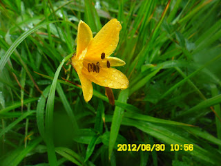
I saw many “Narikko”which means “tiger lilies” along the trail. They are one of typical suumer flowers. I saw this flower for the first time this summer, and I saw many during this rainy hike.
[Tiger lilies, オニユリの花、나리꽃]
After about 30 minutes since we started, I saw a nice pine tree on the observation rock. There was an alter and the stone plate on which many Chinese letters were written.
[The alter of "JeongGukGiDoDan",「靖国祈祷壇」、"정국기도단" ]
It was written as「靖国祈祷壇(JeongGukGiDoDan)」 in the middle and「白頭大幹(Baekdudaegang) 中元地(Middel Center Point)」on the left and「白衣民族(民族中興)聖地、不失其祖 三巴水」on the right.
Korean people were used to be known as “while cloth people”because of their favor of “white color” as a symble of cleanness (or purity), I guess.
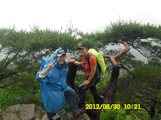
President Jeondaoun, and Minji (in charge of general affairs) were the only women who joined this hike. They were kind enough to be waiting for me, and without raincoats! They are storng ladies in deed.
[At a lookout with the president and other staff members, 展望台にて、전망대에서 ]
We arrived at the top of Mt. Cheonghwasan at 11 am. After taking the picture at the top of the mountain, we kept ridge walking for about one hour, then we caught up with the top group having lunch in the woods.
[At the top of Cheonghwasan, 青華山山頂にて、청화산 정상에서]
We took the place for lunch as the top group left the site. Unfortunately it rained even hard while we were having lunch. “J-nim” provided a big plastic sheet and they connected each corner to the trees in the wood, making the sheet as a temporary roof.
[Lunch in the woods in the rain, 雨が降る森の中で昼食、비가 내리고 있는 숲 속에서 점심]
When the rain gathered in the center of this temporary roof, one of the connection became loose, and water poured on the heads of people under the roof.
We all got wet whatever we tried to do. Anyway, I used my umbrella while having my lunch.
After the lunch, we came to the rocky part of the ridge. We must have been very careful to climb up or to walk down the rocky place because it was very slippery.
Then we came down to a heli-port. We had a short break there and separated into two groups.
[At a heliport, ヘリポートにて、헬리기장에서]
One group kept ridge hiking and climbed the 2nd peak (Mt. Johangsan), and the other group went down to the village. I joined the latter (easy) one.
We came to a dam which had been almost dried up (Korea had been suffering from the lack of rain for several months.)
[At Uisang Reservoir, ウィサン貯水池にて、의상 저수지에서]
Then we came into a villege with some great pine trees. The most famous pine tree is called “Wang Song” which means “King Pinetree.”
["Wangsong" or "King Pine"、「王松」、왕송]
After taking pictures of the King Pinetree, finally we arrived the destination where our chartered bus was parking.
We asked a nearby restaurant to use a tent to prevent the rainfall. We had the wrap-up party under the tent and left the parking lot at 5 pm.
We came back to Expo South Gate in Daejeon at around 7 pm. I took a 606 bus to go back to my place “Shinseongdong.”
Actually it was my first experience to take a 606 bus. (I did not know that this bus went to Shinseongdong.)
I learned a new thing after living Shinseongdong for 6 years.
It was my 33rd hike for this year and 286th AhToSan hike as the total number.
----------------------------------------------------------------------------------
登山月日:2012年6月30日(土)雨
登山地:忠北(충북)、槐山(괴산)の青華山(청화산)・鳥項山(조항산)
登山コース:ヌルジェ(늘재)-青華山(청화산)-カッパウィジェ(갓바위재)-鳥項山(조항산)-サムゴリ-ウィサン貯水池(의상저수지)-龍松(용송)-オギャンドン(옥양동) (約13km/6時間)
同行者:アトサン会員23名
山行地の忠北・槐山は近場なので7時に出発しても9時に現地到着した。
さすがに今回のコースは悪天候という事もあり、アトサン以外の山岳会は皆無だった。
出発地点のヌルチェには9:15に到着した。バスを降りると左側には「洛東江・漢江、分水嶺」の看板があり、左側には白頭大幹と大書した大きな石碑が立あった。
[A group picture before the hike, 出発前の集合写真、출발전의 단체사진]
また、その右側には「城隍堂」があり、左側にはその由来を刻んだ石板があった。
城隍堂(성황단=서낭단ソナンダン)とは、「城隍神を迎えて法事を行う家」とあり、ネットで調べると「村の入り口にある聖なる木や、石塚,家、チャンスン,石塔,ドルメンなどの前で毎年祭祀を行う。これは豊作と多産,魔退けと福を招きが目的で、正月に村人たちが集まって拝む。」とあるシャーマニズムの祠の様だ。
降りしきる雨の中、松の林の登山路を2.8km登った青華山まで登った。今回も最後尾をなんとかあまり遅れないように頑張った。
林の中に入ってすぐにオレンジ色の夏の花、「ナリコ」を見つけた。この先、このナリコはじつに多く見た。約30分ほど登った見晴らしの良い稜線に立派な松と岩があり、そこに「靖国祈祷壇」という真新しい碑が建てられていた。
[The alter of "JeongGukGiDoDan",「靖国祈祷壇」、"정국기도단" ]
その文字の右には白衣民族(民族中興)聖地、不失其祖 三巴水とあり、左には白頭大幹 中元地とあった。「白衣民族」とは漢民族のことであり、「白衣民族(民族中興)聖地、不失其祖 三巴水とは洛東江と漢江及び錦江のことだろうか。
[Hemerocallidoideae, キスゲ(忘れ草)の花、애기원추리 꽃]
さて、約1時間ほど進んだ坂の途中で、アランドロンたちが私を待っていてくれて、スズキタイムにした。今回はいつものチョンボドやパングルトマトに換えて、小粒の種足しブドウとマスクメロンをちいさく切ったものを用意したがどちらも好評ですぐに終わった。
青華山の頂上には11時ちょうどに到着した。石標はずいぶんかわいいもので、認証写真を撮った。この日、たった2人の参加女性であるチョンダウン会長とミンジ総務は雨具も使わずにたくましい。
[At the top of Cheonghwasan, 青華山山頂にて、청화산 정상에서]
その後さらに1時間ほど尾根伝いに進んだ、ややひらけた場所で先頭グループが食事を終え、出発しようとしているところに追いついた。
われわれも同じ場所で昼食をとることにした。12人ほどの会員は周囲の木立を利用してJニムが持参したビニールシートを張り、その下で食事をした。
[Lunch in the woods in the rain, 雨が降る森の中で昼食、비가 내리고 있는 숲 속에서 점심]
私はその下に入りきれないので傘をさしながら弁当を食べた。そういえば昔、やはり雨が強く降った時、私が持参したビニールシートで似たようにテントを張ったが、ビニールにたまった雨水が一気にこぼれてびしょ濡れになったことがあったっけ。
今回も同様にルチニムの頭の上に雨水がまとまって落ちた。
食事の後、さらに尾根伝いに進むと見晴らしの良い岩場に出た。岩場は特に濡れて滑りやすいので注意が必要だ。
岩場を下ってさらに進むと13:20にヘリポートに出た。この手前に一気に下山する道があり、中間・後尾の15人のうち、私を含む5人が鳥項山には向かわず、下山することにした。
グループが分かれる前にマッコリとビールで乾杯。私を含む5人はそのまま下山した。
途中、なだらかで広い林道に出たが、私以外は渓谷沿いに降りた。私は一人で林道を下ったが、これは正解だった。
というのは4人が渓谷から林道へ出る前に私が先に出たからだ。林道はそのまま工事中の貯水池に続いていた。
貯水池は干ばつのためかひび割れした湖底が露出していた。ダムを過ぎるとワンソンマウル(왕송마을)に入り、樹齢600年の「昇天の松」を見学した。
[At Uisang Reservoir, ウィサン貯水池にて、의상 저수지에서]
くねくねと天に向かって曲がり、まるで龍が昇天するすがたのようだというこの松の木はたしかに立派だ。
["Wangsong" or "King Pine"、「王松」、왕송]
松の見学を終えて、バスに到着したのは15:30だった。バスに着いたときは全身ずぶぬれで、上のシャツと下着を乾いたものと着替え、靴下は脱いで靴の中にトイレットペーパーを何度も入れては交換したが、最後まで乾くことはなかった。
打ち上げパーティはバスの前の天幕を借りて実施。おかげで雨にぬれることなく、パーティを楽しんだ。メニューはピョンユクとおいしいマッコリ。今回はピョンユクを最後の1枚まで食べた。
["Pyeonyuk", slices of boiled meat, ビョンユック(肉片)、편육]
フルコースを歩いた最後のハイカーがバスに着いたのは16:30で、バスは17:00に出発した。
南門には明るいうちに到着した。帰りは初めて606番のバスに乗って新城洞へ帰った。なんと606番バスのバス停は南門のすぐ前で、新城洞も私のワンルームのすぐそばだった。これなら604番バスよりよほど便利だということがわかった。
今回は私の今年33回目の登山であり、アトサン企画山行に参加した総数は286回目である。
登録:
コメントの投稿 (Atom)


You actually make it seem so easy with your presentation but
返信削除I find this matter to be actually something that I think
I would never understand. It seems too complex and very broad for me.
I am looking forward for your next post, I'll try to get the hang of it!
Also see my web page > cool articles about health
Thanks for your comments. So far, I hiked mostly in Korea, many places in Japan, and 5 or 6 places in China, and three times in North Korea (Geumgangsan twice, and Baekdusan once). My experiences are so limited and so were my knowledge and understanding.
削除I spent one week in Australia and 4 weeks in Japan after this hike. These experiences were also good for me and I am now uploading my experiences with pictures after this blog.
Thank you for your interests and have a good day!