It was a super fine day. The chartered bus left Expo-South Gate at 7 a.m. and arrived at Daegi village at 10 a.m.

[About 40 people joined the hike, 約40人が参加した。 약 40명이 참가했다.]
Among 40 perticipants, there were only 2 foreigners, B (Mexican) and I. B bought a new camera, so he was eager to hike.

[At the first rocky slop, 最初の岩場、최초의 암석 지대]
GamAmSan locates just next to HwangMeSan National Park. It was really a rocky mountains, but there were not many hikers that day. One reason is it is not as famous as HwangMeSan. Yet it was challenging, and fun to climb rocks upon rocks.

[Members on the rock, 岩の上に立つ会員たち、바위 위에 서는 회원들]
The whole group became 3 small groups according to hiking pace. Top group, 2nd group, and 3rd group. B walked with Top group, but I walked with the 2nd group.

[The Hawk Rock, メパウィ(鷹岩) 매바위]
We did not see each other until the end of the hike. 5 and half hours later.
Top group made the peak of GamAmSan by noon, but the rest of us couldn’t. We had lunch on the big rock before GamAmSan.

[Lunch on the big rock、岩の上で昼食、바위 위에서 점심]
Afternoon hike was also challenging, but ridge hike was relatively easy because it was well facilitated with wires, ropes, and even steel steps.

[The steel steps, 鉄の階段、철계단]
The final peak was called BuAmSan (695m) then we descended to the village called “Igyo Maul.”

[The final peak, BuAmSan, 最後の峰・傅岩山、마지막 봉우리인 부암산]
The time difference of each group was about 30 minutes, each.
As for the tippuri party, they served spicy soup with big bones of pig. It was very spicy yet delicious. Both B and I enjoyed it with the rest of AhToSan hikers.

[After-the-hike party, ティップリは豚の骨汁、뒷풀이는 감자탕]
2010年4月3日(土)アトサン定期登山261回(私は195回目)の登山は慶南・陜川の甘闇山(カムアムサン감암산:828m)で久しぶりに快晴。また、大田からも近いため、南門7時に出発。明るくなってからの出発は、明るいうちの帰着とともの今年初めてのことだ。
今回の外国人の参加者はメキシコ人のBと私だけ。Bは先週、富士のデジカメを購入して張り切っている。

[B was eager to take pictures with his new camera,Bは新しいデジカメで熱心に写真撮影、B은 새로운 디카로 열심히 사진촬영]
バスはテギ・マウルへ10時に到着。甘闇山をバックに記念撮影をしてから登山開始。渓流に沿って登ってから木製の橋を渡るとすぐ岩場。ここで40人近いグループは、先頭、中間、後尾の3グループに分かれた。Bは先頭グループ、私は中間。
最初の目標はメパウィ(매바위)で、鷹岩という意味だが、その姿に由来するのだろう。メパウィはかなりの難所で、特に登ってから、下るのが難しかった。

メパウィを過ぎても岩場が続き、今回は特に天気もとびきり良かったため、写真撮影に時間がかかった。中間組は、2時間ほど登った展望のよい場所で昼食。
先頭組はすでに甘闇山頂上に到達していた。また後尾は約30分遅れて中間に追いついた。昼食は少なくとも3カ所でラーメンを煮て、弁当と共に食べた。

[The top of GamAmSan, 甘闇山(カムアムサン山頂、감암산 정상]
昼食後、中間組がまず、出発。30分ほどで、甘闇山頂上に到着した。ここから次の目的地の傅岩山(プアムサン부암산:695m)までも岩場が多く、場所によってはワイヤーやロープ、また鉄製の階段などが設置されている。

[Steel steps, 鉄製の階段、철계단]
山自体の奇岩も素晴らしかったが、天気が良かったため、周囲の山々もよく見えてすばらしかった。特に目立った山は伽耶山だった。

[Jindalle flowers at the skirt of the mountain, 麓に咲いていたチンダルレの花、기슭에 피어 있었던 진달래 꽃]
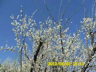
花はサンスユやセンガンナムの黄色の花のほか、麓ではチンダルレや梅の花がきれいだった。特に村の近くの梅林は白い梅の花が満開だった。

[Ume blossoms were in full bloom,梅の花は満開、매화꽃은 만발]
約5時間から5時間半のハイキングの最終ゴールはイキョマウル(이교마을)という村の駐車場で、山岳会のバスはアトサンのみ。
ティップリは大きな豚の骨の入ったカムジャタンのようなスープで、これは辛いものに目がないBがいたく気に入って、お代わりを連発、私も彼に負けずにお代わりをした。
0 件のコメント:
コメントを投稿