Destination (mountain): BangTaeSan (1444m)
Hiking course: Parking Lot – MaeBongRyong – Top of GuRyongBong (1388m) - Top of BangTaeSan (1444m) – Valley – Parking Lot (10.2 km, 6 hours)
Partner: About 30 AhToSan members,
BangTaeSan is in Inje in GangWonDo, just below under North Korea. So we left one hour earlier than usual, at 6 am at Expo South Gate.
We took the first rest at Yeoju Service Area. There were a jet fighter on display here. I wonder if it was used at Korean War.

[At Yeoju Service Area with Ruchi, 『ルチ』と驪州(ヨジュ)SAにて、『루치님』과 여주 휴게소에서]

[The hiking leader of the day explains the course, 山行大将がこの日のコースを説明している、산행대장이 이날의 코스를 설명하고 있다.]
We arrived at the entrance of BangTaeSan at 10:40, It was cloudy when we left Daejoen, but when we arrived there, it was clear.

[The bus arrived at the hiking area, バスが現地に到着した、버스가 현지에 도착했다.]
They charged “Entrance Fee” of 1000 won for each hiker, so the total fee for this hike was 21,000 won.
After paying the entrance fee, we still went on about 1 km more until the parking lot along the river. There were 3 buses already parking and we were the 4th bus that day.
It was a camping area. I saw many people camping around the river. Camping is a popular past time in Korea now.
After taking a group picture, we went through the camping area. The entrance of the trail was at the end of camping area. We began walking along the river.

[A group picture before the hike, 出発前の集合写真、출발전의 단체사진]
Because of much rain these days, the volume of water was plenty. It must be famous for the nice waterfalls, I saw several shallow waterfalls along the river.

[A stream flowing on the trail, 登山路を横切る小川、등산로를 가로지르는 시냇물]
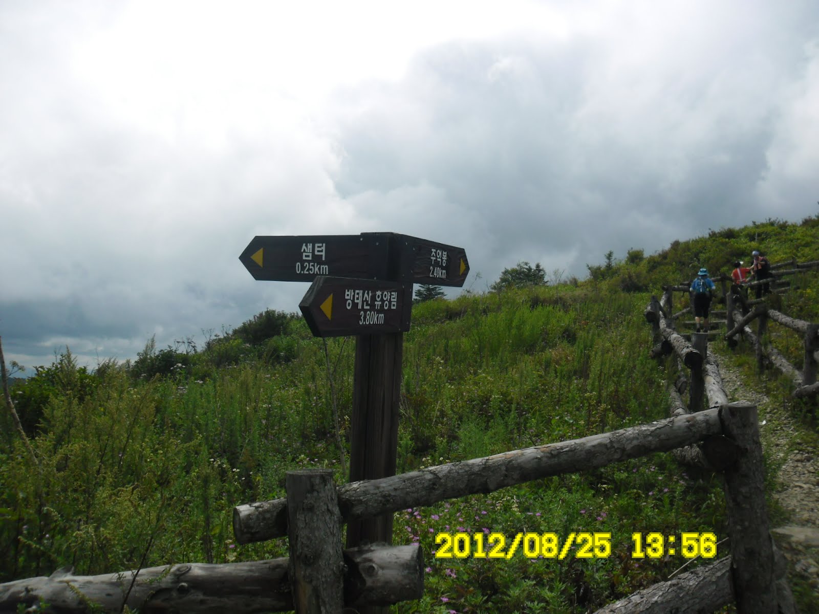
We soon came to a bifurcation point. We turned to left toward “MaeBongRyong.”
For me it is always hard until I came to the ridge. About one hour after the group picture, some members were waiting for me.
I offered grapes as well as oriental melons (in stead of mini-tomatoes). Actually, oriental melons are cheap and delicious during the summer in Korea. I like these oriental melons, too.

[Many members were waiting for me in the woods, 多くの会員が私を待っていた。많은 회원이 나를 기다리고 있었다.]
We arrived at MaeBongRyong at 12:38. It is on the ridge and I like ridge walking very much.
We had lunch at MaeBongRyong. After having lunch, I took a group picture and we began afternoon hike.

[Lunch at MaeBongRyong, 『メボンリョン』で昼食、『매봉령』에서 점심]

[A member of AhToSan offered the fruit of mulberry, 会員の一人が『桑の実』を提供、회원중 한 사람이 『오디』를 제공]
We were heading for “GuRryongDeokBong (1388m)”from there.
I saw many flowers along the trail, such as “Campanula”, “Aconite” and “Geranium thunbergii”.There were also a lot of butterflies and bees and other insects on or in the flowers.

["Geranium thunbergii", one of the most popular folk medicines、薬草として有名な『ゲンノショウコ』、약초로서 유명한 『이질풀』]

[Campanula punctata (Spotted Bellflower) or "Hotarubukuro" in Japanese, ホタルブクロ(蛍袋)、"초롱꽃" or "탑잔대"]


[A butterfly on a flower of thistle, アザミの花に止まった蝶々、엉겅퀴 꽃에 앉은 나비]
“Campanula”is known as “Hotarubukuro” in Japanese and “”Chorongkkot (초롱꽃)”in Korean. One of the staff members of AhToSan laso let me know this flower as “톱잔대”. They are in a same family.
There were also a lot of “Aconitum” or in Japanese “Torikabuto”or “Tugukkot투구꽃 “ in Korean. It has variety of English manes such as aconite, monkshood, wolf's bane, leopard's bane, women's bane, Devil's helmet or blue rocket. It’s because a poisonus plant.

[Flowers of "Aconitum,トリカブト(鳥兜)の花、바곳 꽃]

[A heliport near GuRyongDeokBong, 九龍徳峰近くのヘリポート、구룡덕봉 가까이의 헬리포트]

[The sky and mountains in GangWonDo, 江原道の空と峰々、강원도의 하늘과 산들]

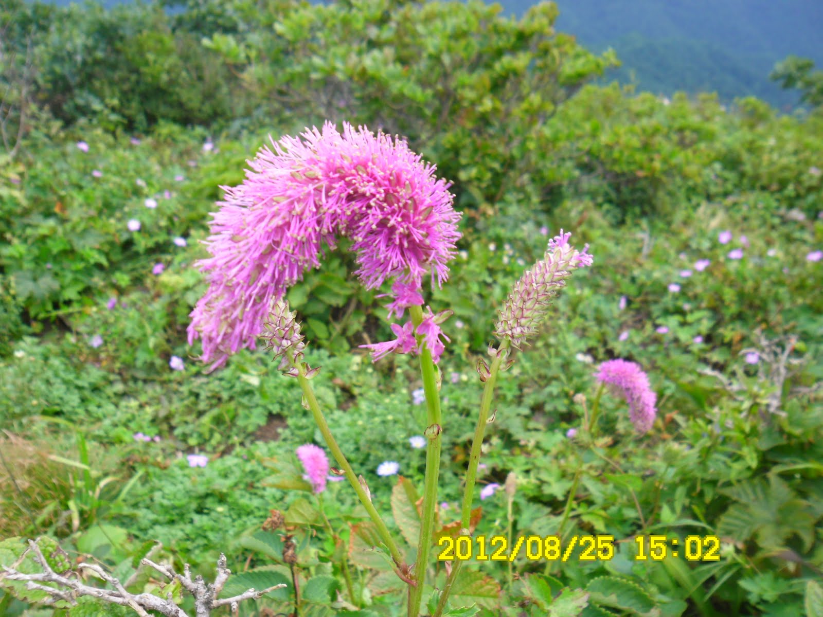
[A bee and “Lychnis” or “Dongjakko동자꽃” in Korean, センノウ(仙翁)と蜂、동자꽃(童子花)과 벌]
We arrived at GuRyongDeokBong at 2 pm. It was facilitated with wooden trails and it was a gentle hile. There again were a lot of beautiful wild flowers including “Gentiana scabra” or Japanese “rindo.” The color of the flowers is dark blue or blight blue.
[Acalypha, a plant genus of the family Euphorbiaceae、エノキグサ属キャッツテール、붉은여우꼬리풀/아칼리파렙탄스]
Apart from GuRyongDeokBong about 1.4 km, there was a bifurcation mark, witch says 400 meters to BangTaeSan. We we went directly to the top of BangTaeSan and returned. It was again full of wild flowers.
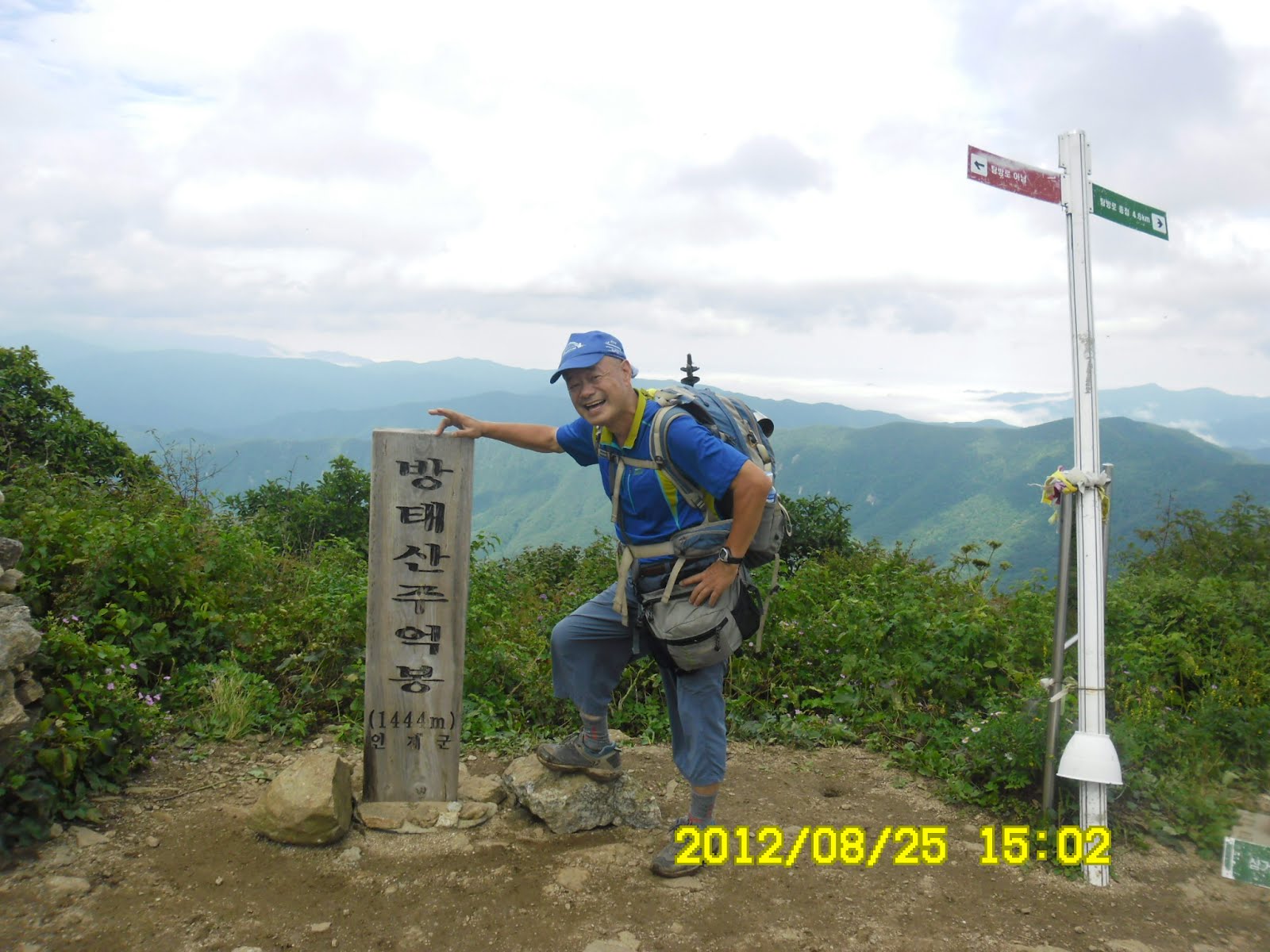
[At the top of BangTaeSan, 方台山山頂にて(1444m)、방태산 주억봉 정상에서]
At that poit, it was past 3 pm. We had to be back to the bus by 5 pm. So I hurried to descend the mountain.

[Flowers of "Aconitum,トリカブト(鳥兜)の花、바곳 꽃]

["Gentian" or "Rindo" in Japanese, リンドウの花、용담 꽃]
I think I am good at descending hike because I still have staple knees. So, I was the top among the middle group.
When I came to the river, however, Grace and Mochong caught up with me. They were also walking fast. I kept up myself with their pace, that made the descending hike faster.
When I came to a good photo point of waterfall, I saw Hangeryong and Baengnihyonag. They are good cameramen, so we took picutres each other.

[At a good photo point of waterfall, 下山路の滝、하산로의 폭포]
I arrived at AhToSan bus at just 5 pm. Many of fast hikers were already having wrap-up party with Pajong and Mackgeolli.

[At the wrap-up party, 打ち上げパーティにて、뒤풀이 파티에서]
The last members arrived at our bus at 6 pm. So we left as soon as they arrived at our bus.
We came back to Expo South Gate at 10 pm. I went back to my studio apartment by utilizing a public bus.
It was my 44th hike for this year and AhToSan 288th regular hike for me to join them.
------------------------------------------------------------------------------------------
登山月日:2012年8月25日(土)
登山地:江原道、麟蹄の方台山(방태산)1444m
登山コース:方台山自然休養林駐車場~メボンリョン(매봉령)-九龍徳峰(구룡덕봉1388m)-方台山頂上(1444m)) - (지당골)- 方台山自然休養林駐車場(10.2 km, 6時間)
参加者:アトサン会員30名
目的地の方台山は江原道でも最北部で、北朝鮮と境界を接する麟蹄(인제)郡にあるため、今回も南門を6時に出発した。
京畿道の驪州(여주)サービスエリアで最初の休憩をしたが、ここにはジェット戦闘機が展示されていた。この戦闘機は朝鮮戦争の時に使われたものなのだろうか。

[At Yeoju Service Area in Gyonggido, 京畿道の驪州サービスエリアにて、경기도 여주 휴게소에서]
目的地の方台山自然休養林駐車場に到着したのは10:40だった。
出発時は曇っていたが、現地では青空が広がって気持ち良い。
今回は入山料1000ウォンが加算されたため参加費は21000ウォン。料金を支払った管理事務所からさらに渓谷沿いに細い舗装道路を約1キロほどバスで進んで駐車場に到着した。

[A staff member is paying the entrance fee, スタッフが入山料を支払っている、스탭이 입산료를 지불하고 있다.]

[The bus arrived at the hiking area, バスが現地に到着した、버스가 현지에 도착했다.]
すでに先着のバスが3台止まっていた。太陽の光を浴びて集合写真を撮り、キャンプ場を左右に見ながら、渓谷に沿ってさらに1キロほど登ったところが登山道入口で、渓流に沿って登った。
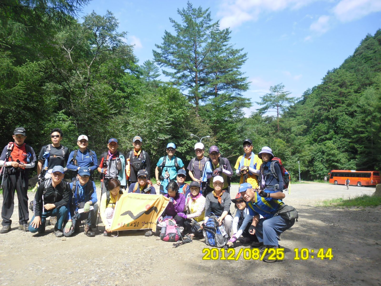
[A group picture before the hike, 出発前の集合写真、출발전의 단체사진]

[A stream flowing on the trail, 登山路を横切る小川、등산로를 가로지르는 시냇물]
渓流には西丹沢でみたような丸太橋がかかっているがかなり老朽化していてすぐにでも新設備と交換が必要なようだ。
キャンプの客も登山客も多いのだから、経済的には簡単なことだろう。ここのところ続いた雨のため、渓流の水量が多くて、特に滝がみごとだった。
登山路に入ってすぐ、左右の分かれ道の標識があり、左折してメボンリョン(매봉령)という尾根に出るコースに入る。
約30分ほどは渓流沿いの登山路で、登山路にも水がしみ出て歩きにくい。
その後、本格的な上り坂になり、周囲は原生林の雰囲気がただよっていた。
出発して約1時間後の11:38にアランドロンたちとスズキタイムの休憩。持参したブドウとマクワウリが一気になくなり、荷物が軽くなった。

[Many members were waiting for me in the woods, 多くの会員が私を待っていた。많은 회원이 나를 기다리고 있었다.]
尾根を登り切ってややひらけたメボンリョン(매봉령)に着いたのは12:38なので、出発してから約2時間だ。ここで、約20人ほどで昼食にした。

[Lunch at MaeBongRyong, 『メボンリョン』で昼食、『매봉령』에서 점심]
うっかりしたことに携帯用の椅子をまたしても家に置き忘れ、地べたにKSからもらった敷物を敷いて座ることになった。
1時には昼食を終え、1:08に集合写真を撮ったから、休憩は約30分したことになる。ここから右折して九龍徳峰(구룡덕봉1388m)へ向かった。

[A group picture after the lunch, 昼食後の認証ショット、점심후 인증 사진.]
登山路の両脇にはホタルブクロ科の変種で実にかわいくてきれいな「탑잔대꽃」とトリカブト、及び이질풀(痢疾草、和名ゲンノショウコ)が多数見えた。

[Campanula punctata (Spotted Bellflower) or "Hotarubukuro" in Japanese, ホタルブクロ(蛍袋)、"초롱꽃" or "탑잔대"]

[Flowers of "Aconitum,トリカブト(鳥兜)の花、바곳 꽃]
尾根伝いに30分ほど進むと、かなり広い林道のような明るい道に出た。この広い道の両脇にもいろいろな花が咲いていて、花に群がる昆虫も多い。

[A butterfly on a flower of thistle, アザミの花に止まった蝶々、엉겅퀴 꽃에 앉은 나비]

「タプチャンデ」と「ゲンノショウコ」のほかに特に目についたのは「トリカブト」で、紫の濃淡の具合がさまざまなバリエーションで実に多かった。

[Flowers of thistles, アザミの花々、엉겅퀴의 꽃들]

[White mushrooms along the trail, 登山路の白いキノコ、등산로의 흰 버섯]
また、菊の小花が多重に重なって開いているような花や、黄色い花などもたくさん見ることができてよい。
時折、林道横の林の中の道からは江原道の北部の峰々が見えた。

[The sky and mountains in GangWonDo, 江原道の空と峰々、강원도의 하늘과 산들]
九龍徳峰の頂上には午後2時に到着。木製の展望台が整備され、頂上はなだらかな丘のようで、リンドウも多くみられた。
[Near the top of GuRyongDeokBong, 九龍徳峰の頂上の頂上付近、구룡덕봉 정상 부근]

["Gentian" or "Rindo" in Japanese, リンドウの花、용담 꽃]

[“Lychnis” or “Dongjakko동자꽃” in Korean, センノウ(仙翁)属、동자꽃(童子花)]
九龍徳峰から1.4km進んだところに方台山頂上へ400mと書かれた分岐点があり、ここから方台山頂上までをピストンした。
方台山頂上も九龍徳峰同様になだらかな丘陵のような頂上で、お花畑のような雰囲気だ。ここでも大きなリンドウが咲いていて、写真が撮れた。

沢に出るまでの下山コースは傾斜も急でぬれていたため、1回滑って尻餅をついた。左足の小指を少しすりむいたが、大事には至らなかった。

[A slippery descending trail, 滑りやすい下山路、미끄러지기 쉬운 하산로]
[At the top of BangTaeSan, 方台山山頂にて(1444m)、방태산 주억봉 정상에서]
下り坂はかなり急スピードで下り、上りの時のスズキタイムで出しそびれたキュウリとマウワウリを自分で食べた。
とくにマクワウリは甘くてうまかった。ちょうど食べ終わったころ、モッチョンとグレイスに追いつかれた。この二人はかなり速いペースで歩いたので一緒に歩いた分、下山時刻が早まった。
下りの渓谷のポイントで寒溪嶺と百里香に会い、写真を撮り合った。方台山休養林の駐車場に着いたのはちょうど5時ごろだった。

[At a good photo point of waterfall, 下山路の滝にて、하산로의 폭포에서]

すでにティプリをはじめていた人々は約20人ほど。左足の傷の化のう止め薬を飲んでいるため、マッコリは最初の1杯だけにして、ヨレジが作ったパジョンを食べた。

[At the wrap-up party, 打ち上げパーティにて、뒤풀이 파티에서]
今回初めて来た男女3,4人が最後に戻った時は6時近かった。
ティップリの時間が長引いた分、しこたま酔った者もいたようで、私の席のすぐ後ろの男性がなぜ老人のくせに勉強するんだとやや絡んできたが「独島」の話はしなかった。
現地を午後6時に出発して、途中往路と同じ場所で休憩したが、ティップリ後にちょっと降った雨が止んでちょうどこのころ虹が出た。
南門には10時ごろ到着。西区保健所まで歩いて10:30ごろ106番バスに乗って新城洞に戻った。
今年44回目の登山であり、アトサン定期登山の参加回数は288回目。
0 件のコメント:
コメントを投稿