In order to go to Kamikochi from Matsumoto, we have to buy tickets at the counter of Alpico. You cannot buy tickets in advance, only the day you take bus, first come, first serve basis. So I went to the counter before 5 am and bought 11 tickets; 7 tickets for men were one way, and 4 tickets for ladies were round trip. Men were to stay at Yarigatake Sanso (槍ヶ岳山荘), and ladies were to walk around Kamikochi and return to stay in Matsumoto one more night.

We all took 5:30 bus and headed for Kamikochi. We arrived at 7:06 at Kamikochi. All men put their luggage to the luggage hold counter while I filled in “hiking registration (登山届)” form.

Men were to walk 22 km from Kamikochi to Yarigatake Sanso, so we could not waste any time. But all of us walked together to Kappabashi (河童橋), the famous sightseeing spot. We took some group pictures there, then men began to walk fast.

To my surprise, ladies also walked fast, up to Myoji Branch (明神分岐). When we, men were taking the first “take-five” rest, the ladies caught up with us. So, again we took some group pictures there, but it was the last group pictures all together.


The middle point of the whole distance was Yokoo Lodge (横尾ロッジ). The distance was 11 km from Kamikochi and another 11 km to Yarigatake Sanso. We came to Yokoo Lodge at 10:30.

The trail become a little by little, steep from Yokoo. But up to Yarisawa Lodge (槍沢ロッジ), it was not too difficult. It is a pleasant shadowy trail along the Yarisawa River. We arrived at Yarisawa Lodge at around noon.

We had lunch there. Then the trail becomes more and more difficult. By the place called “Babadaira(ババ平), all men walked by their own pace and differently. I was the last person to walk among our group.


I was walking hard, while seeing at trail at foot. I should have seen upward, too, but when I realized I came to scree‐covered slope. I knew there were such places close to the peak of Mt. Yari, but not so soon.

Then I could see the peak of Mt. Yari, the pyramid-like triangle shape. I also felt strange, because it was too soon to see the shape. Then the trail I was walking was getting farther away from Mt. Yari. Now I realized that I took the wrong trail! I turned back and went down the way I climbed.


About 20 to 30 minutes I went back, then I saw the guidepost saying “Tenguhara Bunki (天狗原分岐).” So, I missed this guidepost and turned the wrong direction.


I hurried up to follow my Korean friends. Passing through “Bozuiwa (坊主岩)” I saw the number marks saying the rest of the distance to Yarigatake Sanso.


When I came to the 300 meter mark, I could see someone waving his arms in front of the lodge. When I came to the 100 meter mark, I saw two Sydney Hikers waving their arms from the bottom of the pyramid-like rocks. They were also Sydney Hikers.


Finally I arrived at Yarigatake Sanso at 18:00. I hurried to fill in the check-in form. Then I realized that one person had not arrived at the lodge yet! It was Mr. Yu who had calcification problem in his lungs.

We could see Mr. Yu walking toward the lodge, but very slowly. I went down to pick his bag up, and encouraged him to walk faster. He was just like at the 7th station of Mt. Fuji, feeling dizzy and uncertain. When he finally arrived at the lodge it was 18:52. He joined the supper table but had no appetite at all.

He told us that he mistook “Sessho Hutte (殺生ヒュッテ)” as Yarigatake Sanso. “Sessho Hutte” is located underneath of Yarigatake Sanso. There was a guidepost which showed the branch, but it was written in Japanese, no English.
I regretted that I myself missed the branch guidepost of “Tenguhara” and could not support him at that time.
Anyhow, we all arrived at Yarigatake Sanso, and four of us successfully climbed the top of Mt. Yari.
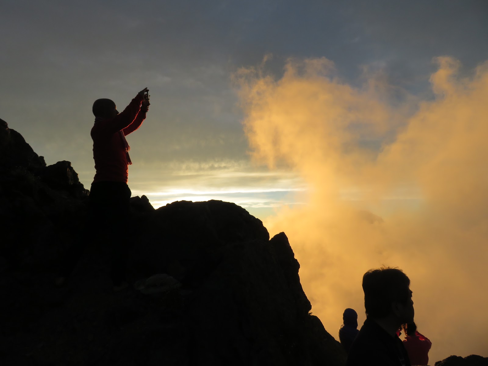
The sunset was extraordinary beautiful and especially the peak of Mt. Yari reflected the sunset was indeed impressive for me.
------------------------------------------------------------------------------------------------
シドニーレポート 第10号 「富士山と槍ヶ岳 山岳ガイド」#5 「槍ヶ岳登頂」
松本から上高地へ行くには、バスターミナルのアルピコへ行き、上高地行きの切符を買わなければならない。予め買うことはできず、当日、窓口に並んで買う。
私は5時前にカウンターへ行き、私を含めて11人分の座席を確保した。このうち女性陣4人は往復切符で、男性7人は片道切符である。

女性たちは上高地のみ散策し、男性は上高地から標高3080mに位置する槍ヶ岳山荘まで22kmを歩いて山荘に一泊する。
男性たちの不要な荷物は上高地バスターミナルの手荷物預けに預ける。女性たちは翌日荷物を持って上高地バスターミナルで、我々と合流し、東京行きの高速バスに乗車する予定だ。
松本バスターミナルは5時半の始発で上高地到着は7:06である。上高地に到着すると男性たちは荷物を預け、私は登山届に登山計画を記入して提出した。

1週間前に私が一人で下見に来たときは5時半に上高地を出発したので約2時間遅れでスタートしたことになる。一人で下見した時はちょうど12時間かかったので、よほど急がないと明るいうちに槍の穂先に登頂するのは難しい。

全行程の22kmのうち、3分の2先にある槍沢ロッジまでは一緒に行き、そこから先は、後続を待たずに先着順に山荘に向かい、山荘に到着したらバッグを置いて、「槍の穂先」に挑戦することを勧めた。
このコースでは槍沢ロッジまで、ほぼ1時間おきに目標があり、明神分岐、徳澤ロッジ、横尾ロッジ、槍沢ロッジの順だ。
河童橋で集合写真を撮ってから、最初の目標は明神分岐だ。この間の距離は約3.5kmで、最初の休憩をとるにはちょうど良い距離だ。男性陣が分岐点に着いて休憩していると、女性たちも追いついてきた。ここで最後の集合写真を撮った。

女性陣はここまでで、彼女たちには明神池を見学するように勧め、男性陣は先を急いだ。上高地バスターミナルから梓川に沿った横尾までの道は平たんで、しかしその梓川の上方には穂高連峰をはじめとした北アルプスの山々がみえる。

また、森林帯でもあり、大きなキノコなどもあったりした。

我々は丁度半分の行程11kmをほぼ3時間で歩き、横尾分岐点に到着した。横尾大橋の前でふたたび集合写真を撮った。

横尾分岐からいよいよ槍ヶ岳へ向かって梓川を離れ、槍沢カールを流れてくだる、槍沢に沿って登る。ここはまだ勾配が緩やかで、心地よい樹林帯の登山道だ。槍沢ロッジにはちょうど昼頃到着し、ここで昼食をとった。この後は本格的な登山コースで各自、それぞれのペースで槍ヶ岳山荘を目指した。

私は自然としんがりをつとめ6人の後を進んだ。登山中にいろいろなことを考える。ちょうど10年前、ベルギー人の友人フィリップと初めて槍ヶ岳に登ったことなどを考えていた。

ババ平を過ぎたころ、気が付くとガレ場で岩に丸印が付いている場所をたどっていた。あれ、少し早いなと思いつつも進むと槍ヶ岳の山頂が見えて来た。あれ、これも少し変だなと思いつつさらに進むと槍ヶ岳を右手に見ながら次第に遠ざかっていく道を歩いていることに気づいた。


しまった、どこかで道を誤ったと悟り、元来た道を引き返した。20分から30分ほど引き返すとなんと「天狗原分岐」の道標に気づかず、分岐を反対側に左折してしまったことが分かった。
ただでさえ、みんなから遅れているのにさらに遅れると思い、必死で登り始めた。しかし、登山路には雪渓もあり、また高山植物も美しい。ついつい、足を止めて写真を撮る。


ジグザグの登山路である角を曲がると、槍ヶ岳の穂先が見えてくる。このあたりからガレ場は本格的になる。

坊主岩前後に現れる山荘までの距離を示す数字が減るのを頼りに歩くとあと300mの数字のあたりで小屋の前で私に向かって手をふる人間が確認できた。

あと100m時点では「槍の穂先」からまさしく下っている李さんと崔さんが確認できた。二人も私を確認したようで片手を高々と突き上げている。


私が山頂に到着した時刻は18時であった。途中で道迷いをして1時間ほど浪費したが、一人で登山した時の所要12時間を1時間ほど短縮できた。
槍ヶ岳山荘の宿泊受付をしていると、なんと仲間の一人がまだ到着していないということが分かった。

それは肺の石灰化症状のある柳さんだ。シドニーハイカーズの仲間が登山路をゆっくりと登ってくる柳さんを確認した。
私はすぐに迎えに降りたが、彼は富士山の七合目付近の時と同じ高山病の症状でふらふらであった。
私が彼のリュックを持っても、簡単には足が進まない。標高3000m付近の空気は彼には薄すぎたようだ。また、悪いことに、槍ヶ岳山荘の手前の分岐先になる「殺生ヒュッテ」を槍ヶ岳山荘と誤認し、こちらへ行って休んでいたそうだ。
柳さんが到着した時刻は18:53。この日は夕日が非常に美しかったが柳さんは疲労困憊極まったようで、夕食も口には入らなかった。

せめて自分がもう少し早くフォローしていれば、またなによりも道迷いなどしていなければ、柳さんに追いついて、「殺生ヒュッテ」には行かなくてすんだのではないかと心残りである。
ともかく、7人全員無事に槍ヶ岳山荘に到着し、そのうち4人は槍の穂先にも登頂成功したわけだからよしとしよう。
この日の夕日は実に美しく、その夕日に映える槍ヶ岳山頂も実に美しかった。
0 件のコメント:
コメントを投稿