Destination (mountain): Amagisan (Mt. Manjirodake & Mt. Manzaburodake)
Hiking course: Amagikogen Golf Course Bus-stop – Yotsuji – Mt. Manjirodake (1,299m) – Mt. Manzaburodake (1,405m) – Yotsuji – Bus-stop
Partner: None.
"Amagisan" is one of 100 best mountains in Japan.
Mt. Amagi:
http://en.wikipedia.org/wiki/Mount_Amagi
I climbed Amagisan twice before. When I climbed this mountain for the first time, it was May in 1967. I traversed the mountains alone.
I climbed this mountain again 4 or 5 years ago. That time, similar to this time, during the winter and I was alone.
This was my third time, and again, there was no partner, but I kept this record for my hiking blog.
I took the 6:04 am train of Tokaido Line and changed trains at Atami. I saw a beautiful sunrise from the Pacific Ocean on my way.

[The sunrise from the Pacific Ocean near Oizo, 大磯付近の日の出、오이소 부근의 일출]
From Atami to Ito, I took an Ito Line train. I arrived at Ito Station at 7:45 am.
The sattle bus between Ito Station and Amagikogen Golf Course left at 7:55 at Bus-Stop Number Three. It was a big bus but there were only two passengers including me.

[A few passengers on the shuttle bus, シャトルバスの乗客は少なかった。셔틀 버스의 승객은 적었다.]
The fee was 500 yen and it took about 50 minutes. So I think it was very reasonable price. I was just afraid that the bus company would abandon this business.
There were only 6 buses available during the day. So, I checked the bus schedule on my way back to Ito Station.

[The time table for the bus service, バスの時刻表、버스 시간표]
The entrance of the trail was obvious with a nice sign plate. There are two courses, one is to travers Amagisan mountains, the other course is a loop course to climb two hightest peaks of Amagisan. I took the latter one.

[The entrance of the trail, 天城山縦走登山路入口、아마기산 종주 등산로 입구]

[The guide-map for "Shakunage Course", 『しゃくなげコース』の案内図、"석남 코스"의 안내도]
The fork point called Yotsuji was about 30 minute walk from the entrance. Then I turned left and walked toward Mt. Manjiro, first.
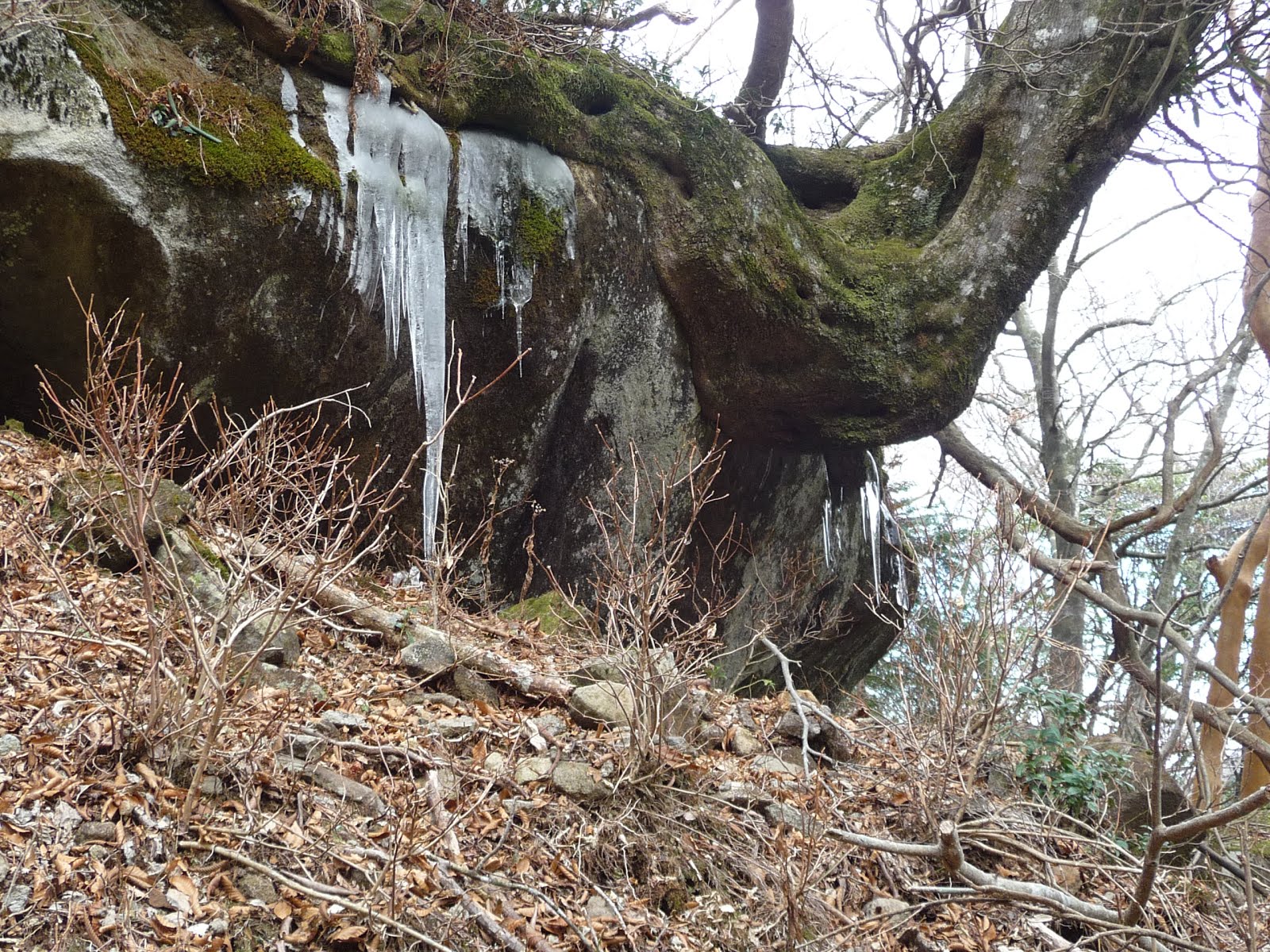
It was a gentle slope but as I approached to the top of the mountain, I could see “Juso” or frost on trees here and there.

[The frost on trees near the top of Manjirodake, 万次郎岳頂上付近の樹霜、만지로다케 정상 부근의 상고대]
I arrived at the top of Manjiro at 10:24 am. After having a short break, I kept going along the ridge to Manzaburo.

[At the top of Manjirodake, 万次郎岳頂上にて、만지로다케 정상에서]

[Manzaburodake seen from Manjirodake, 万次郎岳からみた万三郎岳、만지로다케에서 본 만자브로다케]
I walked through “Umanose” and “Hanadate”, then came to the tunnel of “Asebi.”Asebi is “Pieris japonica” (Japanese andromeda) and written as “Drunken Horse Tree馬酔木” in Chinese characters because the leaves of this tree contains poisons and if horses ate them, they would suffer.

[The tunnel of Japanese andromeda, アセビ(馬酔木)のトンネル、아세비 (마취목)의 터널]

Asebi:
http://en.wikipedia.org/wiki/Pieris_japonica

[The explanation of "Asebi", アセビの英文説明、아세비 (마취목 )의 영문 설명]

[The guidepost at Hanadate、石楠立(はなだて)の里程標、하나다테의 이정표]

[The frost on the trees near Manzaburodake, 万三郎岳付近の樹霜、만자브로다케 부근의 상고대]

[The sea of Izu from Manzaburodake, 万三郎岳から見た伊豆の海、만자브로다케에서 본 이즈 앞바다]
I arrived at the top of Manzaburo at 11:54. There I saw a couple hikers taking pictures. I took pictures of them and I asked them to take my picture.

[At the top of Manzaburodake, 万三郎岳頂上にて、만자브로다케 정상에서]

[The frost on the trees at the top of Manzaburodake, 万三郎岳頂上付近の樹霜、만자브로다케 정상 부근의 상고대]
The “Juso” or frost on the trees were beautiful here and moreover, I could see Mt. Fuji clearly.

[Mt. Fuji from the top fo Manzaburodake,万三郎岳頂上から見た富士山、만자브로다케 정상에서 본 후지산]

[The frost on the trees at the top of Manzaburodake, 万三郎岳頂上付近の樹霜、만자브로다케 정상 부근의 상고대]

I ate lunch here and began decending the mountain.

[The frost on the trees on the way of descending, 下山路の樹霜、하산 길의 상고대]

[On the way to descend the mountain, 下山路にて、하산 길에서]

[On the way to descend the mountain, 下山路にて、하산 길에서]
I arrived at Yotsuji at 2:07 pm and came back to the bus stop before three o’clock and I took the 3:10 bus to Ito Station.

[The sign says "Welcome back!" 『おつかれさまでした。』"수고하셨습니다. "]
There were a few passengers both on the bus and the Ito line train.
There was a little trouble on Tokaido Line, but I came back to Ofuna at 6 p.m.
This was my 2nd hike of the year 2013.
-------------------------------------------------------------------------------------------------------------
分類:登山、日本、関東
<
登山月日:2013年1月11日(金)
登山地:日本百名山の1つで伊豆の天城山のうち万次郎岳(1,299m第二最高峰)と万三郎岳(1,405m最高峰)
登山コース:天城高原ゴルフ場~四辻~万次郎岳(1,299m)~馬の背~万三郎岳(1,405m)~四辻~天城高原ゴルフ場バス停
同行者:なし、
天城山は日本百名山の1つであり、私は今回で3回目の登山だ。
天城山:
http://ja.wikipedia.org/wiki/%E5%A4%A9%E5%9F%8E%E5%B1%B1
初めて登ったのは二十歳の時で天城峠から八丁池を経て天城山を縦走した。この時も単独行で、現地で静岡から来ていた女性3人グループに会った。
2度目は韓国に住むようになってからで4,5年前、今回同様、万次郎岳、万三郎岳をめぐる石楠花コースだった。
今回はブログに掲載する目的であえて2回目と同じコースを歩いた。
この日、大船を6時4分発の東海道線下りに乗り、熱海乗換で伊東で下車した。途中、大磯付近で太平洋から昇る朝日が美しかった。
伊東駅前7:55発の天城高原ゴルフ場行きシャトルバスに乗った。約1時間のバス代金は一律500円で、乗客は私の他、若い女性ハイカー1名のみ。

[There were only two passengers on the bus, バスの乗客は二人だけ。버스 승객은 둘만.]
バスは大型で45人乗り。乗客が二人では赤字間違いなし。いつまで赤字運営を続けてくれるか心配だ。
下車した天城高原は標高約1000メートルというので今回の登山の標高差は500メートル足らずにすぎない
。 登山口はバス停から伊東駅方面へ約50メートルほど戻った左側で、向かいの駐車場はハイカー用のもので無料。

`[The guide map of the trails for Amagisan traverse, 天城山縦走路案内板、아마기산 종주로 안내판]
立派なトイレもあったが、冬季は凍結のため使用できない。
登山道の標識は日・英・中・韓の4か国語対応になっており、登山道も比較的良く整備されていた。
[The notice written in 4 languages, 四か国語で書かれた注意書き、네 가지 언어로 쓰여진주의 사항]
天城高原ゴルフ場を起点とするループハイキングコースは「しゃくなげコース」として約8キロメートル。
シャトルバスの時刻表も1日5本で、8時50分に到着して15:10の復路なら、実に無駄がない。
私は前回同様、左回りで万次郎岳→万三郎岳コースにした。万次郎岳までのコースは傾斜も緩やかで楽なコースだ。

[The trail to Manjirodake, 万次郎岳への登山路、만지로다케에 가는 등산로]
途中、ハイカーにはまったく会うことはなく、ヒメシャラの大木など見どころがあった。

[A big tree of "Himeshara" or "Stewartia monadelpha", ヒメシャラ(姫沙羅)の大木、히메샤라 (공주 사라)의 거목]
頂上には11時前に到着した。頂上付近の樹木には霜がつき、みごとな樹霜ができていた。

[The frost on trees near the top of Manjirodake, 万次郎岳頂上付近の樹霜、만지로다케 정상 부근의 상고대]

[At the top of Manjirodake, 万次郎岳頂上にて、만지로다케 정상에서]

[Manzaburodake seen from Manjirodake, 万次郎岳からみた万三郎岳、만지로다케에서 본 만자브로다케]
万次郎岳から万三郎岳へ続く尾根は馬の背とよばれる辺りも樹霜が見事で、途中、アセビのトンネルを抜けて、万三郎にはちょうど12時ごろ到着した。

[The sign board saying "Umanose", 『馬の背』と書かれた標識、"말등"라고 적힌 표지판]

[The tunnel of Japanese andromeda, アセビ(馬酔木)のトンネル、아세비 (마취목)의 터널]


[The frost on the trees near Manzaburodake, 万三郎岳付近の樹霜、만자브로다케 부근의 상고대]
万三郎岳の頂上ではちょうど中年の夫婦が記念撮影をしており、ツーショットを撮ってやり、私も写真を撮ってもらった。

[At the top of Manzaburodake, 万三郎岳頂上にて、만자브로다케 정상에서]
万三郎岳では今回のコースで唯一、富士山が見え、写真撮影に成功した。また、樹霜の木々のトンネルも見事だった。
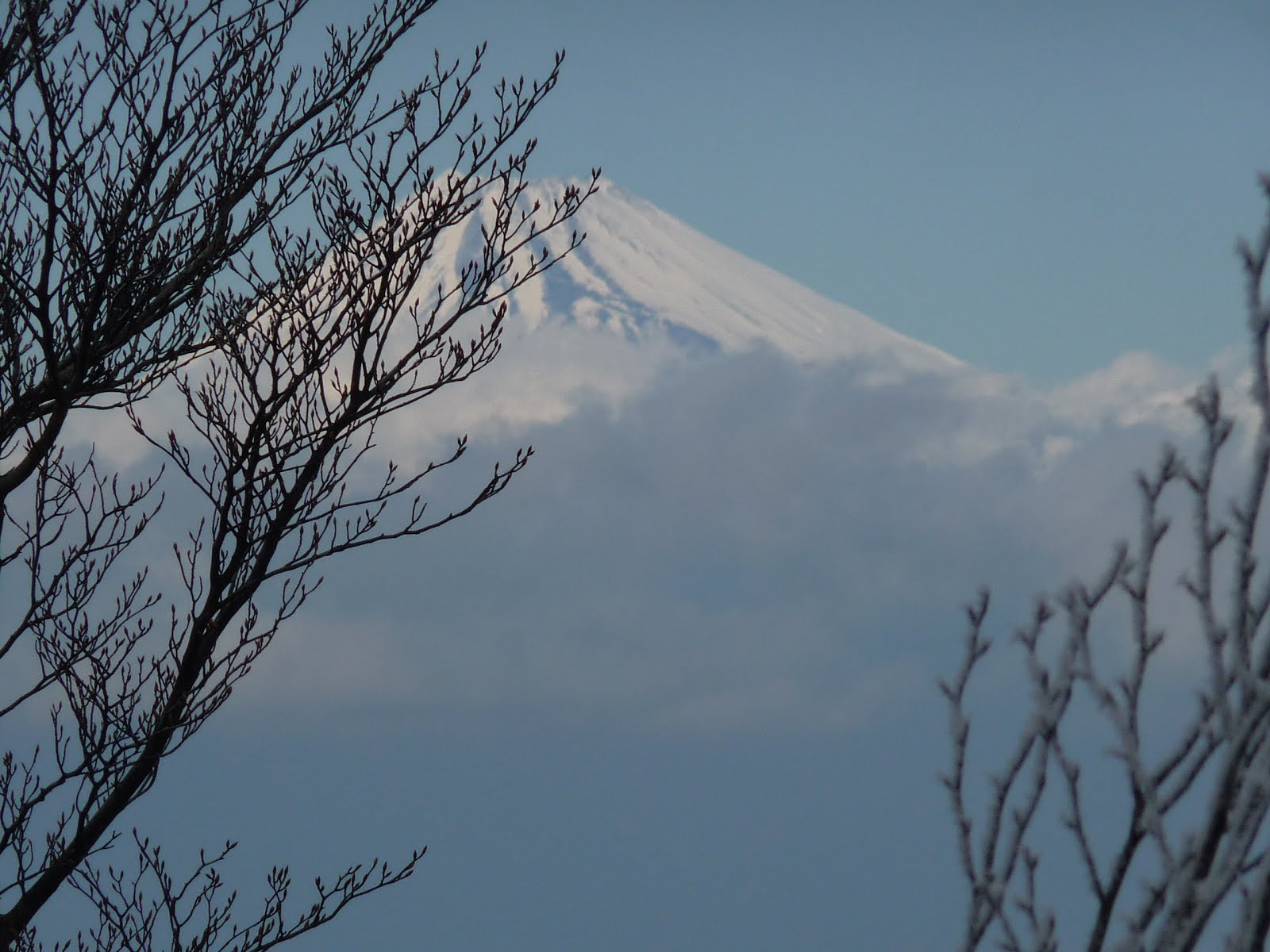
[Mt. Fuji from the top fo Manzaburodake,万三郎岳頂上から見た富士山、만자브로다케 정상에서 본 후지산]

[The frost on the trees at the top of Manzaburodake, 万三郎岳頂上付近の樹霜、만자브로다케 정상 부근의 상고대]

万三郎岳で昼食にしてカップラーメンとおにぎりのランチを食べた。

[The sea of Izu from Manzaburodake, 万三郎岳から見た伊豆の海、만자브로다케에서 본 이즈 앞바다]
万三郎岳からの下りはやや急で、一気に樹霜のない標高まで下った。


[On the way to descend the mountain, 下山路にて、하산 길에서]

ここからループの起点の四辻までは上り下りがある登山路で一部登山路が崩れていた。

[The guide-post at Yotsuji, 四辻の道標、여쓰지의 이정표]
四辻からゴルフ場の登山路入口までは意外と距離があり、途中でカップラーメンとおにぎりの第2ランチを食べた。
バス停には14:45頃到着。帰りのバスは15:08に乗客ゼロで到着した。
復路は途中で女性客が2名乗車したので乗客は3人で伊東駅まで戻った。

[The train of Ito Line on the way home, 帰りの伊東線の電車、돌아 오는 길의 이도선 전철]

16:10には伊東駅に着いたが、熱海駅で16:44発の快速アクティが大磯で人身事故のため遅れ、17:05頃の出発になった。大船到着は6時ごろ。
今年2回目の登山は天気にめぐまれて快適だった。
0 件のコメント:
コメントを投稿