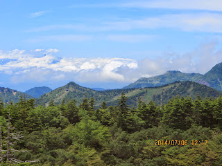
Date: July 8 (Tue) 2014 Fine
Destination: Kusatsu-Shiranesan草津白根山(2,160m), Gunma Prefecture, Japan
Tour: Mainichi Mountain Tour (Bus)
Course: Parking Lot – Ropeway – Summit Station – Foot of Lift – Mount Motoshirame (2160m) – Kagaminuma – Summit Station – Parking Lot
Typhoon 8 was approaching to Okinawa, and stimulating “Rain Front” those days.
I bought 6 rice balls or “onigiri” at Seiyu, and put them into my favorite bag, but I forgot to put rain gears.
I took 5:22 Airport Narita and changed trains at Shinagawa, arrived at Shinjuku at 6:33. The charted bus left at 7 am.
The least number of the trip was 13 and there were just 13 participants. There were 25 seats on the bus. So, I could use two seats for myself.
There were two drivers (one assistant driver) and a tour guide for trekking. So, it might be not very much profitable for Mainihi Shinbun.
Anyway, the weather was not too bad. We did not need rain gears at all.
The destination is close to Kusatsu Onsen, the famous hot spring resort. I saw the new facilities for Chūō Shinkansen:
http://en.wikipedia.org/wiki/Ch%C5%AB%C5%8D_Shinkansen
Mount Kusatsu-Shirane (草津白根山 Kusatsu Shirane-san?) is a 2160 meter active volcano in Kusatsu, Gunma, Japan.
It is called Kusatsu Shirane to differentiate it from the Mount Nikkō-Shirane on the other side of Gunma Prefecture.
The summit of Kusatsu-Shirane volcano, located immediately north of Asama volcano, consists of a series of overlapping pyroclastic cones and three crater lakes.
The largest of these is Yu-gama, an acidic turquoise-colored lake with rafts of yellow sulfur floating on its surface.
Originally the tour was included to Yu-gama, but the frequency of volcanic tremors increased since this April and the volcanic alert was level-up to No. 2 from No. 1 on June 4, 2014, therefore, we could not go close to the summit and could not see Yu-gama this time.
We arrived at the parking lot near the rope-way station at around 10 am.
We all took the rope-way and got off at the summit station at 10:45.
After having exercise, we began walking under the lift toward the summit of Mount Moto-shirane.
I saw many “Iwakagami” or “Schizocodon soldanelloides” along the trail. I have not seen this plant in Korea.
When we arrive at the edge of the crater, I could see many “Komakusa” along the trail.
According to Wikipedia, Komakusa is “Dicentra peregrine,” a herbaceous perennial growing from a rhizome, native to Japan, the Kuril Islands, Sakhalin Island, and northeastern Siberia (including Kamchatka).
I saw Komakusa at Yatsugatake for the first time. It is regarded as “Queen of Alpine Flowers” and I was very much impressed with that beauty.
Since Kusatsu Shirane is an active volcano, the mountain is covered with volcanic rocks, especially near the summit.
“Komakusa” is suitable to live on such soil. So they planted “Komakusa” and now we can see a lot of “Komakura” at Mount Motoshirane.
We arrived at the summit of Motoshirane (this mountain is the tallest among the mountains in Kusatsu Shirane) at noon.
We had lunch here. We could see a part of North Alps of Japan near the summit.
After having lunch, we went back to the fork point, then began walking toward Kagami Numa.
There was a small concrete building on which a round pelorus was on. It was built for the memorial for a young man who died at the age of 29.
After leaving the summit area, we went down toward Kagami Numa.
There was thick mist around the pond, but while we were there, the mist began to clear.
There were flowers of “Hakusan Chidori” or The Keyflower (Dactylorhiza aristata) near the pond.
After seeing the pond, we went back to the rope way station.
There was a mass of snow left along the trail. I also saw “Ginryuso” or “Monotropastrum humile.”
It is also called “Ghost Plant” or “Indian pipe” in USA.
http://en.wikipedia.org/wiki/Monotropastrum_humile
On the way back to the parking lot, I took the gondola (car) of the rope way with a man named “Takai-san” whom I shared on the way up, too.
There were two more people in the gondola. One of them seemed a Chinese woman who spoke Japanese fluently.
We arrived at the parking lot at 2:30, then we began going back to Tokyo.
On the way, they stopped at a shopping center. Just before arriving the shopping center, the micro-bus began making noise.
When we were parking at the shopping center, they check the bus. They found out that a part of cushion got “puncture.”
There was no way to fix it. So the driver drove a bit slowly and carefully to Shinjuku.
So we arrived at Shinjuku at 7 pm. I was thankful that it was a good weather, and safe return to home.
------------------------------------------------------------------------------------------------------
分類:登山、日本、関東,
旅行・登山地:草津白根山(2,160m:群馬県)
旅行・登山月日:2014年7月8日(火)晴れ
旅行日程:毎日新聞社主催山岳ツアー
トレッキングコース: ロープウェイ下駐車場~ロープウェイ山頂駅~リフト下~本白根山頂(2,160m)~鏡沼~山頂駅~駐車場
台風8号が沖縄に接近し、梅雨前線を刺激しているので、山は雨かと心配した。しかし、大船それに東京は良い天気。
前日、西友で購入した1個100円以下のおにぎり6個を持って、使い慣れたリュックで出かけたが、雨具を入れるのを忘れてしまった。
毎日新聞の山ツアーの集合場所は新宿西口住友銀行前で大船発5時22分のエアポート成田で品川に6時に着いたが、山手線の新宿方面は6時17分までない。それなら大船発5時37分の東海道で、品川6時15分でも十分まにあった。
新宿着は6時33分だったが、地上に出るまでもたついて、集合場所には6時50分に到着した。
このツアーの最少催行人数は13人だが、この日の参加者はちょうど13人。バスは25人乗りだったのだろうか、参加者1人が2座席使うことがゆるされた。
運転手は予備の一人も含め2人。案内人が1人で、なんとスタッフは3人だから、利益はかつかつのところだろう。
この日は結局終始好天に恵まれ、本白根山山頂で一時ガスが出たほかは雨が降ることはまったくなく、青空が楽しめた。
目的地は草津温泉が近い。バスの窓から面白い山並みが見えた。また、リニア新幹線のものと見られる施設も数箇所で見えた。
途中、鉄道の近くを走ったときは特急列車のような列車がバスを追い越していった。途中、8時半ごろ上里サービスエリアにつき小休止した。
元来の予定では噴火口にできたコバルトブルーの池である「お鉢」付近までバスで近づいてから登山するはずであったが、先月に入って火山性地震が頻発し、山体が膨張していることから警戒レベルが今年6月4日以降、1から2に上げられたので、「湯釜」付近が立ち入り禁止となったという。
やむを得ず、湯釜の下のロープウェイ駅の駐車場で下車し、参加費に1500円を別途徴収してロープウェイで上まで行くことになった。
今回はコバルトブルーの「湯釜」を見学できないのは残念だ。駐車場に到着した時間は10:20で、ガイドが全員の切符をまとめ買いをした。
ガイドともう一人のドライバーがわれわれに同行し、13人の客の前後を固めた。ロープウェイは6人乗りだが、6人乗るときつい。
私は最初のゴンドラに他の一人の男性客と乗った。彼は自分から高井と名乗り、東京在住だと言う。彼も悪天候を覚悟して来たが予想外の好天に感謝した。
われわれは10:45にはロープウェイ山頂駅で降り、ガイドの小林さんの指導で準備体操をした。準備体操後、リフトの乗り場横から登山を開始した。
リフトに沿ってリフトの頂上に近づくにつれ、足元にイワカガミがたくさん見えてきた。イワカガミは韓国で見たことはほとんど記憶にない。
リフトの頂上から離れた本白根山の大きな噴火口の縁に到着すると展望が開け、足元にはコマクサが多く見え始めた。
コマクサは2年前、やはり毎日新聞のツアーバスで行った八ヶ岳で初めて見た。あのときは未明に到着し、山小屋で仮眠。雨天に歩き始めて温泉小屋付近で雨が上がり、頂上を目指して夕方、頂上付近の山小屋でみたコマクサは新鮮だった。
翌日は天候に恵まれ、硫黄岳まで稜線の絶景を楽しんだが、硫黄岳付近でコマクサの群落を見て感激したっけ。今回のコマクサの群落は本白根の火山性の地面に移植したものだというだけあって硫黄岳以上に大規模である。
旧噴火口の縁に沿ってなだらかな登山道をいったん下り、反対側の縁からまた緩やかに登ると本白根遊歩道の最高地点である2150m地点に到達した。
この付近でちょうど12時になり、昼食休憩になった。噴火口側の半分は良く晴れて、青空と白い雲が美しかったが、反対側は雲がやや低く、ガスってやや展望が悪かった。
それでも眼下の町や遠くの山々も見ることができ、何よりも雨に降られなかったのは幸いである。昼食は昨日西友で買ったおにぎりを3個食べて十分満腹した。
最高地点を少し過ぎた場所が開けていて、北アルプスの一部が見えた。しかし雲がかかってはっきり見えなかったのは少し残念であった。
昼食後、途中の分岐点までもどってから大きな岩のみえる、最高地点とは反対側の小高い場所に登った。この付近もコマクサの群落が見えた。
頂上には丸い方位盤を載せたコンクリートの建造物があったが、これは1967年に当時29歳の青年が8ミリ撮影中に心臓麻痺で死亡したことを悼んで山岳会の人々が建てたものだという。
29歳とは実に若くて気の毒だった。この第2の頂上で小休止後は、なだらかな下山路を鏡池へ向かった。
この下山路は植生が豊かで、コマクサはもうない。代わりに白い星型の花や、同じく白く丸っぽい花、それにカスミ草のような小さな花をつけた高山植物が群生していた。
それにうれしいことに、ギンリュウソウ(銀竜草)も少なからずあった。英語名は「インディアンパイプ」である。
鏡池を望む地点には13:10に到着した。しかし鏡池は木々が邪魔をしてまったく見えない。ガイドの小林さんによると通常は「ここが鏡池です」と言ってすぐ先に進んでしまうそうだが、今回は全員が良いペースなので、鏡池のほとりまで行くことにした。
登山路はハイマツが茂ってちょっと厄介だが、鏡池近くにはハクサンチドリが登山路の左右に一株づつ咲いていて良かった。
われわれが鏡池に到着したときはガスが出て、ファンタスティックといえば幻想的だが、しばらく写真撮影するうちにガスが晴れ、池がクリアに見えた。
水を触ってみるといくぶん暖かい。はたして温泉水なのだろうか。鏡池を後にして、ロープウェイの山頂駅までのコースは意外と長かった。
途中、唯一、残雪のある場所があり、そこは土砂崩れがあったらしく緑のシートがかけられていた。
この地点を過ぎるとすぐローウウェイの山頂駅だった。下りのロープウェイのゴンドラは4人で乗った。一人は往路でいっしょだった高井さんで、一人の女性はなにやら中国人のようだったが、彼女はあちこち日本の山を登っているようで、癖のある日本語ながら、いろいろ話を聞かせてくれた。
ロープウェイは箱根の地獄谷のような場所を通ったが、まわりには石楠花の花がたくさん咲いていた。ここの石楠花の花は白っぽかった。
ロープウェイの駅に着いたのは午後2時半で、これから帰路についた。ゴンドラに同乗した男性二人と話をしたが、せっかく有名な草津温泉に来たのに温泉に入らないで帰るのは残念だ。帰路の途中で1時間の温泉ストップがあってもいいのではないかという話になった。
帰路は途中、お土産屋に寄ったがその後、急にバスがバンピィでなにか後輪に引っかかっているような音がしだした。私は最後列から2番目の席だったが、マイクロバスはこんなものだろうと思って、読書を止め、MP3で聖書を聞き始めたら、最後列の女性が私に「バスがおかしい。なにか故障じゃないか?」と訴えた。
私は今考えれば正しく反応せず、「こんなもんじゃないか」と答えたが、彼女は納得せず、最前列に座っていた小林ガイドに「これはおかしい」と訴えた。
小林さんは最後列に座って、「たしかに異常だ」と同意し、休憩を早めて最寄のサービスエリアにバスを止め、ドライバーが後部車輪を見た。
すると、すぐ「ちょうちん」と呼ばれるエアクッションがパンクしていることがわかったが、修理はできない。結局、速度を落としてゆくことになった。
新宿に到着したのは午後7時過ぎ。帰路は東海道の新宿ラインで45分ほどで大船に戻った。
I like hiking very much. I used to go hiking with a Korean hiking club named “AhToSan.” This blog introduces mostly my hiking activities in Korea and Japan, and Sydney in Australia. As of January 2020, I live in Sydney suburb. I go Blue Mountains and bush walk in Sydney area. 私は2003年から2014年まで韓国の大田(テジョン)に住んだ日本人である。11年間、週末は主に「アトサン山岳会」に参加した。14年4月に帰国したが、2020年以降はおもにシドニーで暮らし、時折、日本へ帰国する程度である。したがって最近の記事はSR(Sydney Report)としてブルーマウンテンのトレッキングを中心に書いている。
About pictures/当ブログ内の写真について/당 블로그내의 사진에 대해서
Most of the pictures in this blog are taken by my camera, yet some of them were downloaded from the website of the hiking club. If you click any pictures, they become the original size.
当ブログ内の写真の大部分は筆者のカメラで撮影したものですが、一部、山岳会の共有写真からダウンロードしたものを含みます。すべて、各写真をクリックすれば、元のサイズに拡大します。
당 블로그내 사진의 대부분은 필자의 카메라로 촬영한 것입니다만 일부 산악회 공유 사진으로부터 다운한 것도 포함합니다. 모두 각 사진을 클릭하면, 원래 사이즈에 확대합니다.
当ブログ内の写真の大部分は筆者のカメラで撮影したものですが、一部、山岳会の共有写真からダウンロードしたものを含みます。すべて、各写真をクリックすれば、元のサイズに拡大します。
당 블로그내 사진의 대부분은 필자의 카메라로 촬영한 것입니다만 일부 산악회 공유 사진으로부터 다운한 것도 포함합니다. 모두 각 사진을 클릭하면, 원래 사이즈에 확대합니다.


0 件のコメント:
コメントを投稿