Course: Miyaji station (JR)-Suisenkyo (taxi 1800 yen) Hiking start -> Washimi Daira -> Higasi Mine -> Takadake(1592m) -> Tsukimi Goya Lodge -> Nakadake (1506m) -> Suna Senri (Sand Feild) -> Nakanishi Bus Terminal (End of hiking) – Uchimaki Onsen (bus 800 yen)

[Sensuikyo Ropeway仙酔峡ロープウェイ"센스이쿄"케이블카]
When we started the hike at Suisenkyo at 9:30, it was fine, partially cloudy. But soon, we were in the cloud (fog.) Soon after began walking, we came to the place with many memorial plates. They are for those who lost their lives in Mt. Aso.

[Mt. Aso Information Center ロープウェイ駅の売店=阿蘇山情報センター케이블카 역 즉 정보센터]
The more we went higher, the trail became steeper, and rockier. The temperature became lower, and the wind also became stronger. Mt. Aso is a volcano, but we saw icicles here and there. There was no tree on the mountain, but we saw frozen grasses with fog. Some grasses looked like wine glasses, and others, just like white flowers.

[The female clerk explained the trail売店の女性が登山路を説明してくれた。매점 종업원이 등산로를 설명해 주었다.]
We reached at Takadake (1592m) at 12:30. Then we went down to Tsukimigoya Lodge, and climbed up to Nakadake (1506m). Unfortunately the fog was so thick, that we could not see the active crater, but only crater wall with “crystal of fog.”

[The entrance of the trail. It was fine. 登山路入口、この時はよく晴れていた。등산로 입구, 이 때는 잘 개어 있었다.]
We walked down from Nakadake to Suna Senri. The trail was not clear. They marked the rocks along the trail with yellow paint. The rocks along the trail were friable, so it was slippery. Therefore, we walked carefully, and it took time.

[30 minutes after beginning the hike, it began foggy.登山開始30分後、霧が出てきた。등산 시작 30분후, 안개가 나왔다.]
The mark at Suna Senri was not clear and we were almost lost our way. Yet, M is a hiking expert. He spotted the piles of stones on the ridge. We went to that direction, and came out the paved road near the destination (Yamanishi bus terminal).

[Memorial Plate for the one who was killed while climbing Mt. Aso 阿蘇登山で事故死した人のための記念碑아소 등산으로 사고사한 사람을 위한 기념비]
We finished our hike at 3:15 p.m. and took a bus to Uchimaki Onsen. We arrived at the traditional Japanese style inn named “Uchimaki Sou” at 4:50 p.m.
The cost of the stay including delicious dinner and traditional Japanese style breakfast was 8000 yen.
We enjoyed natural hot spring two times that night and one more next morning.

[One hour after the beginning of the hike, water became iciles登山開始1時間後、岩からしみでる水がつららに。등산 시작 1시간후, 바위로 배어 나오는 물이 고드름에.]
2010年2月13日(土)
コース:肥後本線宮地~仙酔峡登山口~鷲見平~稜線~東峰~高岳(1592m)~月見小屋~中岳(1506m)~砂千里~阿蘇山西バスターミナル~内牧温泉
 [Hoarfrost on the grass,草にできた『エビのしっぽ』、풀에 생긴 『새우의 꼬리』(상고대)
 今回の阿蘇山登山のスタート地点は、仙酔峡ロープウェイ下駅の登山口。JR肥後本線宮地駅からタクシーで約10分(1800円)。ロープウェイの駅は情報センターになっていて、阿蘇山の立体パノラマや資料を見ることができる。また、土産物屋のおばさんは阿蘇山登山に関するデータがみな頭に入っているようで親切に教えてくれる。私とさほど変わらない歳に見えたが、昭和10年生まれというから一回り上だ。私も12年後、彼女のように元気でいたい。
 [Hoarfrost on the rocks,岩にできた『エビのしっぽ』、바위에 생긴 새우의 꼬리 (상고대)]
登山開始は9時30分。小さな沢にかかった橋を渡ると10分ほどは舗装された小道。本格的な山道に入るとすぐ岩の上に石碑群があった。すべて阿蘇で命を落とした人々を悼む記念碑であった。
この記念碑群を過ぎると勾配はきつくなり、また、直登部分も多くなる。高度が上がるにつれ気温も下がり、稜線に出ると風も強くなって、帽子が飛ばされそうになる。
 [Hoarfrost on the grass,草にできた『エビのしっぽ』、풀에 생긴 『새우의 꼬리』(상고대)
 中間地点の鷲見平付近はもっともきつく、溶岩で固まった岩をつかみながら登る。次第に霧も深まるが、風も強くなる。火山なのに水がしみ出る部分が多く、みなみごとなつららになっている。また、草に霧が付着し氷結して白い花のようになっている。
 [With hoarfrost on the rocks,岩にできた『エビのしっぽ』と、바위에 생긴 새우의 꼬리 (상고대)와]
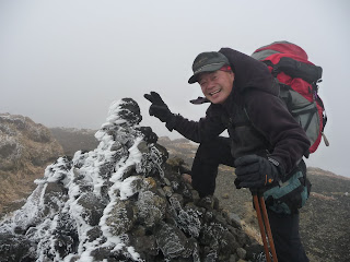
頂上付近では岩に霧が氷結し、それが次第に成長してエビのしっぽのようにみえる。特に石を積み上げたケルンに「エビのしっぽ」がよく見える。

稜線を登りきった東峰には12時11分到着。東峰から高岳(1592m)への道は緩やかで広い道。

昼食は高岳で二人ともバナナ1本のみ。高岳からは中岳への分岐点までもどり、そこから岩に描かれたマークを目印に月見小屋まで下った。

月見小屋からまた登りに入り、中岳への登りに入った。中岳に着くころはガスが濃くなり、遠景は何も見えないが、足元の氷結した草はじつにきれいだった。

中岳から砂千里へ下ったが、この下りはきつかった。最初の登りと違い、足元の岩が不安定で、注意深く足を運ばなければならなかった。

砂千里はじつにその名の通りの砂千里。道標の向きが実際の稜線コースと反対で、あやうく道に迷うところだった。

砂千里から右側の稜線を進むと、ロープウェーの中岳展望台から下った道にある駐車場に出た。ここからは車道に沿ってできたばかりに見えるかなり広い歩道を下ると、以前、アランときたことのある休憩所、およびバスのターミナルについた。したがって登山終了は午後3時15分だった。

バスは3時40分発内牧温泉行き。内牧温泉には4時50分到着。伝統的な旅館「内牧荘」にチェックイン。内牧荘は24時間かけ流しの温泉宿で、豪華な夕食と朝食付き8000円。

0 件のコメント:
コメントを投稿