Destination (mountain): Mt. Yarigatake (3,180m), North Alps in Japan
Hiking course: Kamikochi Bus Terminal – Kappabashi – Myojin – Tokusawa – Yoko-o – Ichinomata – Yarisawa (Lunch) – Babadaira – Yarisawa-O-omagari – Tenguhara – Banryu Cave – Sessho Branch – Yarigatake Branch – Yarigatake Sanso (Lodge)
It's totally 22 km hiking distance. Yoko-o is about the middle point. From the bus terminal to Yoko-o (11km) it took me about 3 hours, but the rest of 11 km, it took me more than 8 hours!
Partner: None
I climbed Mt. Yari with one of my best hiking friends, Philip, in 2008. (Philip is now in Belgium and I miss him very much.)
It took us two days from the bus terminal to the Yarigatake-sanso (22km), but this time, I walked the same distance for a day.
I used the same direct bus from Shinjuku called “Sawayaka Shinshu-go”again. The bus arrived at the bus terminal in Kamikochi at 5:17. (6000 yen + peak time charge 1000 yen)

[I arrived at Kamikochi Bus Terminal at 5:17, 上高地バスターミナルへ5:17到着、가미코치 버스 터미널에 5:17도착]
After having breakfast, I began trekking at 5:40. It took me one hour to Myojin and another one hour to Tokusawa.

[I began trekking at 5:40、5:40にトレッキング開始、 5:40에 트레킹 시작]

[Aconitum or devil's helmet or blue rocket、トリカブト(鳥兜)の花、바곳/투구꽃]

[I arrived at Kappabashi, 河童橋に到着、갓파바시에게 도착]
It took me about one hour from Tokusawa to Yoko-o. That’s about half of the whole distance of the day.
I saw a group of monkeys while walking toward Yoko-o. It must be a family. I saw small monkeys as well as some big ones. The big monkey was walking along the trail for people while small monkeys went in the woods and bamboo bush.

[An adult Japanese monkey, 野生のニホンザルの成体、야생 일본원숭이의 성체]

It was an easy trekking trails from the bus terminal to Yoko-o (11km). The real trail starts from Yoko-o.
I passed Ichino-mata and Nino-mata, joint part of the rivers and arrived at Yarisawa Lodge at 11 am. Philip and I stayed overnight at this lodge in 2008. It was raining hard that time.

[The flow of river near Ichinomata, 一の俣付近の渓流、"이치노마타"부근의 계곡물]

["Gozentachibana" or "Cornus canadense" (Canadian Dwarf Cornel), ゴゼンタチバナ(御前橘)、"고젠 타치바나"]
I had lunch in front of the lodge. It was a clear day and I noticed that there was a telescope near the lodge. We could see the peak of Mt. Yari by the telescope well.

[I arrived at Yarisawa Lodge at 11:00, 槍沢ロッジに11時に到着、야리사와 로지에 11시에 도착]

[The top of Yarigatake seen from Yarisawa Lodge, 槍沢ロッジからみた『槍』の穂先、야리사와 로지에서 본 『창』의 정상]
I started at Yarisawa Lodge at 11:30. Soon, I came to Babadaira camping area. It used to be a lodge before, but snow avalanche crashed the lodge. Now it remains stone walls there.

[Flower of Hemerocallidoideae, キスゲの花、원추리과 꽃]

[Alpine flora, "Hakusan-furo" or "Geranium yesoemse var. nipponicum", 高山植物ハクサンフウロ(白山風露)、고산 식물"하쿠산후로"]
Yet there is a toilet, and water supply there, so it is a poplular place for campers.

[Babadaira Camping Place, ババ平野営場、바바다이라 야영장]
From Babadaira, the trail went to the U-shaped valley, typical landscape formed by glaciers.

["Yarisawa Cirque" seen from Babadaira, ババ平からみた槍沢カール、"바바다이라"로부터 본 야리사와 컬(Kar)]

[An alpine flora, "Miyamakinbai" or "Potentilla matsumurae", 高山植物のミヤマキンバイ(深山金梅)、고산 식물인 "미야마킨바이" ]
[The snow piled up near Yarisawa Omagari, 槍沢大曲付近の残雪、야리사와 오마가리 부근의 잔설 ]
The more I climbed toward Yarigatake, the more difficult the trail became. The trail became steep and steep, and sometimes difficult to distinguish.

[Snowy gorge near Tenguhara, 天狗原付近の雪渓、"탠구하라"부근의 눈 계곡]

[Now I could see the peak of Yarigatake beyond the snowy gorge,ようやく雪渓の背後に槍ヶ岳の頂上が見えた。드디어 설계의 배후에 야리가타케 정상이 보였다.]

["Iwakagami" or "Schizocodon soldanelloides" and Mt. Yarigatake, イワカガミ(岩鏡)と槍ヶ岳、"이와카가미"(바위거울)과 야리가타케]

["Kibana-shakunage" or "Rhododendron aureum", 高山植物のキバナシャクナゲ(黄花石楠花),석남화의 일종, 고산 식물]
There were marks of while circle on rocks. They are right path. But there are X-marks as well, which means no good or do not go to that direction.

[A signal for the trail, 岩に描かれた登山路の印、바위에 그려진 등산로 표시]
A man and his son, having huge bags on their backs, walked ahead of me, then I passed them while they were having rest. They were a father and his son, having camp at Sessho Lodge, near Yatsugatake Sanso.

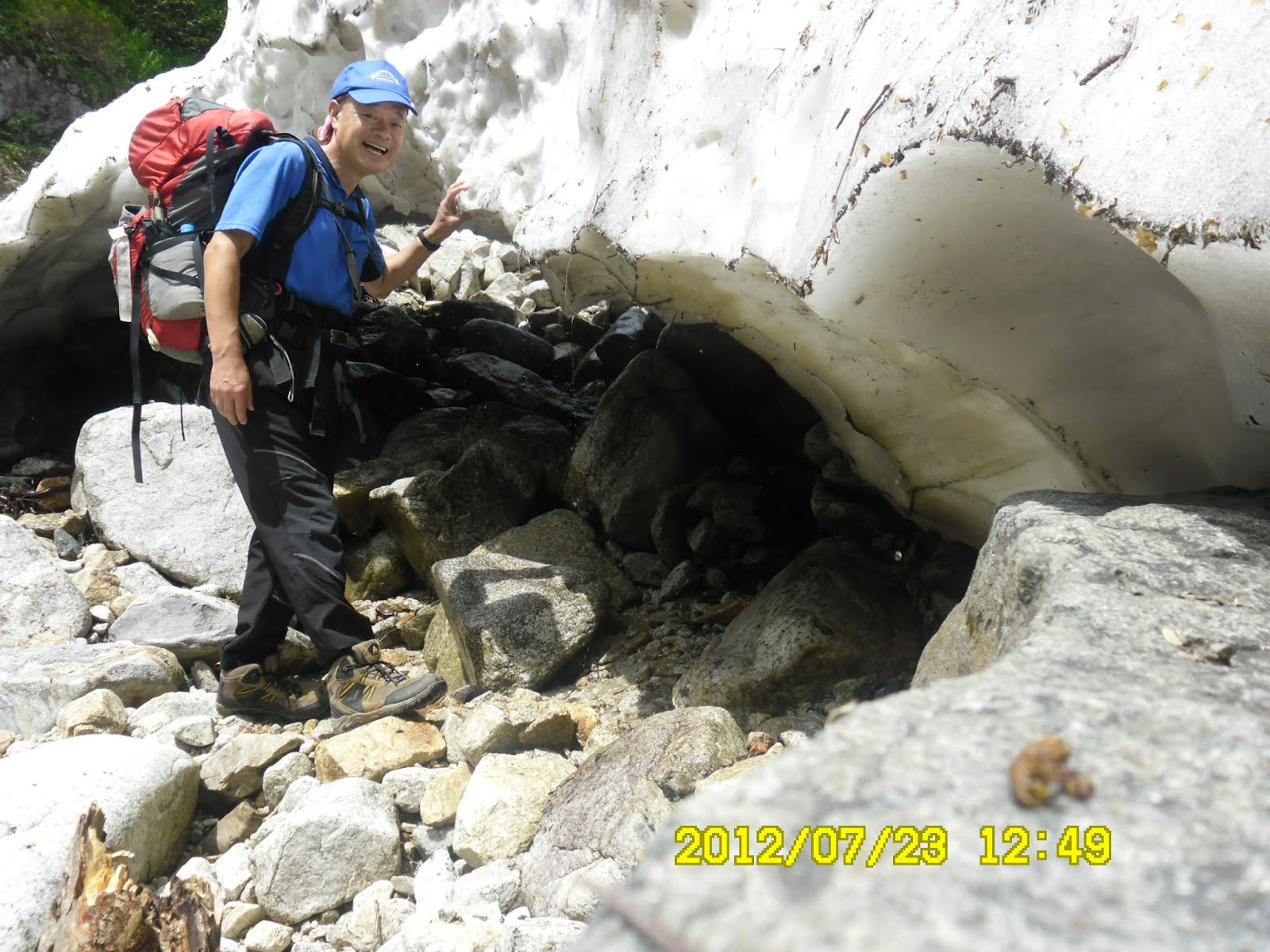
[Near "Bozuiwa" in which a monk trained more than 170 years ago, 坊主岩の下で、"스님"바위 아래에서]


["Banryukutsu" or a Cave where Banryu trained himself about 170 years ago, 「播隆窟」(播隆が1834年に53日間修行した)、 「반류굴」 (반류가 1834년에 53일간 수행했다)]

[Snowy gorge near the top of Mt. Yarigatake, 槍ヶ岳頂上付近の雪渓、야리가타케 정상부근의 눈 계곡]

[槍ヶ岳山荘直下から槍ヶ岳の頂上を見上げる、야리가타케 산장 아래에서 야리가타케 정상을 우러러 본다.]
I finally arrived at Yarigatake Sanso at 5:17. After filling in the check sheet and paid 9,000 for a stay with 2 meals (6000 yen for a stay+2000 yen for two meals), I left my bag there and hurried to climb Mt. Yari.

[At last, I arrived at Yarigatake-Sanso, ようやく槍ヶ岳山荘に到着した。드디어 야리가타케 산장에 도착했다.]
Since the clerk at the lodge told me to return by 6 pm for supper, I climbed the last peak of Mt. Yari by 5:40 pm then came down to the lodge.

[I climbed at "spearhead" of Yarigatake, 槍ヶ岳の『槍』に挑戦、야리가타케의 『창』에 도전]

["Tsugazakura" or "Phyllodoce nipponica Makino" which I saw at "spearhead" of Yarigatake、槍ヶ岳の『槍』部分で見つけた日本固有の高山植物『ツガザクラ(栂桜)』、야리가타케의 『창』부분애서 찾은 일본 고유 고산 식물 『쯔가자쿠라』]
I had my supper at 6 pm and went to the bed of the lodge after the supper. I was so exhausted and went to sleep soon, without getting out of the lodge at night to see the beautiful sky with full of stars.

[The supper at the lodge, 槍ヶ岳山荘の夕食、야리가타케 산장의 저녁 식사]
-------------------------------------------------------------------------------------
登山月日:2012年7月23日(月)晴れ
登山地:北アルプス・槍ヶ岳(3,180m)第1日目
登山コース:上高地バスセンター(5:17)~河童橋(5:50)~明神(6:40)~徳沢(7:30)~横尾(8:45)~一の俣(10:15)~槍沢(11:00昼食)~ババ平(12:10)~槍沢大曲(12:50)~天狗原(14:00)~播隆窟(坊主岩)15:45~殺生分岐(16:23)~槍ヶ岳分岐(17:13)~槍ヶ岳山荘(17:20)[カッコ内は到着時刻]上り22km所要時間約12時間
同行者:なし
2008年にベルギー人の友人フィリップと登山して以来、4年ぶりに槍ヶ岳に登った。
前回二日かかったバスセンターから槍ヶ岳山荘までの22kmを今回は一日で登った。
往路は前回同様、新宿発の「さわやか信州号」で、帰路は予約せず、結果的に新島々行きのバスで松本経由の鉄道を利用した。(料金6000円+期間割増1000円=7000円)
さわやか信州号は途中沢渡での乗り換えもなく、5時17分には上高地に到着した。

[I arrived at Kamikochi Bus Terminal at 5:17, 上高地バスターミナルへ5:17到着、가미코치 버스 터미널에 5:17도착]
簡単な朝食後、5時40分にトレッキング開始。明神まで1時間、徳沢までに1時間、そして横尾まで約1時間と快調に進んだ。

[I arrived at Kappabashi, 河童橋に到着、갓파바시에게 도착]
[Near Myojin Lodge, 明神山荘付近にて、묘진 산장부근에서]

途中、サルの軍団に遭遇したが、これは明神一家かもしれない。大猿は堂々と人の通る登山路を歩く。子ザルは登山路を挟んだ左右の笹原に見え隠れする。彼らは笹の新芽を食べていた。

[An adult Japanese monkey, 野生のニホンザルの成体、야생 일본원숭이의 성체]

さて、私は横尾で25分休憩し、9:10に梓川沿いに登山路に入った。

[The flow of river near Ichinomata, 一の俣付近の渓流、"이치노마타"부근의 계곡물]
前回、2008年にフィリップと登った登山路で、一の俣、二の俣は記憶に新しい。フィリップと泊まった槍沢ロッジには11時ちょうどに到着。

["Gozentachibana" or "Cornus canadense" (Canadian Dwarf Cornel, ゴゼンタチバナ(御前橘)、"고젠 타치바나"]
ここで昼食にして、11時半に出発した。前回は悪天候で分からなかったが、槍沢ロッジの前から槍ヶ岳の頂上付近が見える。ロッジが望遠鏡を設置して登山客が自由にみえるようにしてあった。

[The top of Yarigatake seen from Yarisawa Lodge, 槍沢ロッジからみた『槍』の穂先、야리사와 로지에서 본 『창』의 정상]

[I started Yarisawa Lodge at 11:30, 槍沢ロッジを11時半に出発、야리사와 로지를 11시반에 출발]
ロッジを過ぎて樹林帯の中を進むと右側の赤沢山が迫り、沢が狭くなり、左右にキスゲを見ながらさらに進むとババ平のキャンプ場に出た。

[Flower of Hemerocallidoideae, キスゲの花、원추리과 꽃]

[Alpine flora, "Hakusan-furo" or "Geranium yesoemse var. nipponicum", 高山植物ハクサンフウロ(白山風露)、고산 식물"하쿠산후로"]
ここに残る石積の壁は旧槍沢小屋が雪崩で潰された跡だそうだ。ここには水場もトイレもあるのでキャンプには最適だ。ここからいよいよ槍ヶ岳を頂上にいだく氷河跡のU字谷を進むことになる。

[The remains of the old lodge and "Yarisawa Cirque", 旧山小屋の跡と槍沢カール、구산장의 자국과 야리사와 컬(Kar) ]

["Yarisawa Cirque" seen from Babadaira, ババ平からみた槍沢カール、"바바다이라"로부터 본 야리사와 컬(Kar)]

[An alpine flora, "Miyamakinbai" or "Potentilla matsumurae", 高山植物のミヤマキンバイ(深山金梅)、고산 식물인 "미야마킨바이" ]
ババ平からは雪渓も多く、登るペースも遅くなる。ちょうど14時に天狗原分岐点、そして滝見岩で二筋の滝の写真を撮った。かなり離れた西尾根から流れ落ちる滝の音が良く聞こえた。

[Snowy gorge near Tenguhara, 天狗原付近の雪渓、"탠구하라"부근의 설계]
この後、15時過ぎに以前、サルの軍団を見た岩を過ぎるとようやく槍ヶ岳の雄大な姿が見えた。雪渓の中に入り、槍ヶ岳を背景に認証写真を撮った。

[On the rock from which I saw a group of monkeys in 2008, 2008年にサルのグループを見た岩、2008년에 원숭이 그룹을 본 바위]

[Now I could see the peak of Yarigatake beyond the snowy gorge,ようやく雪渓の背後に槍ヶ岳の頂上が見えた。드디어 눈 계곡의 배후에 야리가타케 정상이 보였다.]

[An alpine flora, "Iwakagami" or "Schizocodon soldanelloides"、高山植物、イワカガミ(岩鏡),고산 식물인 "이와카가미"(바위거울)]

["Kibana-shakunage" or "Rhododendron aureum", 高山植物のキバナシャクナゲ(黄花石楠花),석남화의 일종, 고산 식물]
しかし、ここからの上りは実にきつかった。モレーン台地に登り、坊主岩には15:44。ここから先は雪渓を越えてはごろごろした岩に白ペンキつけられた○印と矢印をたよりに登る。×印は進入禁止である。

["Banryukutsu" or a Cave where Banryu trained himself about 170 years ago, 「播隆窟」(播隆が1834年に53日間修行した)、 「반류굴」 (반류가 1834년에 53일간 수행했다)]

注:播隆(ばんりゅう、1786年(天明6年) - 1840年11月14日(天保11年10月21日)は、江戸時代後半の浄土宗の僧。槍ヶ岳の開山、笠ヶ岳の再興者。(出典ウィキペディア)
このころからやや大きめなリュックを背負った親子と抜きつぬかれつしながら進んだ。ようやく着いた殺生分岐には16:23。この道標には槍ヶ岳まであと1キロで殺生ヒュッテまで150mとあり、槍ヶ岳小屋をあきらめて殺生ヒュッテで泊まろうかと一瞬考えたが、槍頂上をめざすなら、無理しても槍の肩まで進もうと意を決した。

[Looking down the Sessho Hutte (Lodge) from "Shoulder" of Yarigatake, 槍ヶ岳頂上付近から殺生ヒュッテを見下ろす、야리가타케 정상부근에서 "살생 휘테"을 내려다본다]
岩に書かれた数字が800とか500とかあるのは槍の肩(山小屋)までの距離。槍ヶ岳山荘に着いたのは17:17。

[At last, I arrived at Yarigatake-Sanso, ようやく槍ヶ岳山荘に到着した。드디어 야리가타케 산장에 도착했다.]
宿泊者カードに記入して部屋番号のカードをもらったのは17:20を過ぎていた。(宿泊7000円+2食2000円)受付前にリュックを置いて、用意した手袋を出して、半袖のまま槍の頂上を目指したが、途中17:40に頂上に到達できず、ガスも出てきたのでこの時点で登頂はあきらめ、下山した。

[I climbed at "spearhead" of Yarigatake, 槍ヶ岳の『槍』に挑戦、야리가타케의 『창』에 도전]

[『槍』の頂上付近から穂高方面を見る、『창』의 정상부근에서 호타카 방면을 본다]
小屋へ戻ったのはちょうど18:00で最後の夕食時間だった。疲れたせいか、それもとご飯やみそ汁がすでに冷めていたためか、夕食はあまりおいしいと感じられなかった。

[I returned to the lodge before 6 pm, 6時前に小屋へ戻った、6시전에 산장에 되돌아왔다.]
部屋は南館のイワツバメの2段ベットの上段の端。他のグループの人がすでに寝ている隣でわたしもすぐに横になった。
いまから思えば、無理しても日没の山々や、日没後の星空をみに外へ出ればよかった。しかしこの時点では非常に疲れ、すぐに寝てしまった。
0 件のコメント:
コメントを投稿