Destination (mountain): Mt. Hinokiboramaru in Nishi-Tanzawa, Kanagawa Prefecture,
Hiking course: Nishitanzawa Information Center (Nishitanzawa Shizen-Kyoshitsu) – Tsutsuji-Shindo (New trail of azaleas) – Gorasawa-Deai – Top of Hinokiboramaru (1601m) – Inugoeji – Yokisawa-Deai – Nishitanzawa Information Center
Partner: None.
This is my second challenge to climb a mountain in Nishi(West)-Tanzawa. Last time, it was “Azega-maru”on July 18, and this time, “Hinokibora-maru.”
With my limited experience, I know only these two mountains which has “maru” at the ending part as suffix. In Japan, most of the mountain names end as “San” or “Yama” or “Take/Dake”but “maru”is a kind of unique in Kanto area.
When I check “maru” as a part of mountain names, I found there were in Tsurugi Mountains in Shikoku and Hakusan Mountains in Chugoku, etc. So, “maru” is not necessarily “very rate” in Japan.
In Korea, ridges are called “Maru”so it might be some influences of imigrants from Korean peninsula.
Anyhow, I got up at 4 am and prepared for the hike. Had an early breakfast and took a 6 am Tokaido Line train. But I fell in sleep in the train and I passed Kozu where I should change trains!
When I realized, it was Nebukawa! I had to return to Kozu and came to Matsuda rather late. I ended up with the same 8:20 bus bound for Nishi-Tanzawa, same as before.

[In side of the bus bound for Nishitanzawa, 西丹沢行バス内部、니시 단자와행 버스 내부]
I arrived at the bus terminal in Nishi-Tanzawa at 9:40. After filled in the format for hikers at the information center, I began hiking for Hinokibora-maru.
I walked along the paved road toward the mountain along the river for about 500 meters. Then I saw the post-guide for Hinokibora-maru on my right.

[The post-guide for Hinokibora-maru, 檜洞丸への登山口を示す道標、히노키보라마루에의 등산 입구를 나타내는 이정표.]
That was the entrance of the trail. I walked along the small river. There were some fallen trees, but they were not big problems.

[A wooden steps and a guide-post, 木の階段と道標、나무 계단과 이정표 ]
Then, soon I began climbing a bit steep slop which went around the mountain.

[A trail in the woods, 林の中の登山路、숲 속의 등산로]
I came to “Gorasawa-Deai” or the meeting point of two rivers; Gora-sawa and Higasi-sawa [“sawa” is a stream in the valley.]

[A guide-post showing "Gorasawa-Deai", 『ゴーラ沢出会』を示す道標、『고라 데아이(골짜기만남)』을 나타내는 이정 표 ]

[Notice for "Wading across", 『渡渉あり』の標識、"도섭(걸어서 얕은 물을 건넘) 주의의 표식]

[A concrete steps after "Wading across" point, 『渡渉』後の階段、"도섭(걸어서 얕은 물을 건넘)후의 계단]
From “Deai” the trail went to the ridge. It was a plesant ridge walk toward the top of the mountain. There were some places I had to hold chains to climb a steep rocky places, though.

[Some rocky places facilitated with chains, 鎖場もあった。쇠사슬장도 있었다.]

[A short break on the way to the observation deck, 展望台への途中で小休止、전망 대에의 도중에 조금 휴식]
When I came to the observation deck, I saw a nice wooden table and benches, so I had lunch there. (It was a bit cloudy, and there was no good view from the place.) It was 11:30 and I had two rice balls my wife made that morning.

[A view from the observation deck, 展望台からの展望、전망 대로부터의 전망]

[There were mosses and mushrooms here and there, コケ類、キノコ類があちこちに見える、이끼류, 버섯류가 이쪽저쪽으로 보인다]

I saw a few hikers on this mountain. I saw a guy running on the trail (a trail marathon runner) and a group of hikers (4) after having lunch.
After having lunch, I continued walking toward the top of the mountain. As I approached the top, less trees I saw around me. Yet there were still big trees even near the top of mountain.

There were plenty of pink flowers. It is a kind of "Shimotukeso" or a kind of "Filipendula." They were jut in their peak season because I saw this flowers all the way on the ridge trails.

["Shimotsukeso" or a kind of "Filipendula multijuga", シモツケソウ(下野草)、"시모쯔케소" in Japan]

["Hototogisu" or "Toad Lily", ホトトギス(杜鵑草), 『호토토기수』

[Wooden trails near the top, 頂上付近の木道、정상부근의 나무길]
I also saw clusters of plants with yellow flowers. They were “Marubadakebuki” and I walked along the well-facilitated wooden trail in the middle of “Marubadakebuki.”

[Clusters of“Marubadakebuki" or "leopard plant", マルバダケブキ(丸葉岳蕗)の群落、『마루바다 케부키』꽃의 군락]

The scientific name is “Ligularia dentate” and it is also called as “Summer Ragwort” or “Leopard Plant.”
To my big surprise and pleasure, I also found beautiful butterfulies named “Asagimadara” in Japanese, “The Chestnut Tiger” or “Parantica sita.”

[“The Chestnut Tiger” and "Leopard Plant”、マルバダケブキの花に止まった『アサギマダラ』、『마루바다케부키』 꽃에 멈춘 『아사기마다라(왕나비)』]


This butterfly did not afraid of people and was very eager to suck honeydew from “marubadakebuki” or“leopard plant” I could easily catch one of them.
The butterfly is known as its long distance of migrate (between Japan and Taiwan or over 1500km).
http://en.wikipedia.org/wiki/Parantica_sita
(Please refer to Janapese explanation in “移動” which means “migration.”
I arrived at the top of the mountain a t 1:30 pm. There was only a simple pole as the sing of the top of Mt. Hinokiboramaru.

[At the top of Mt. Hinokiboramaru (1601m), 檜洞丸頂上にて、 히노키보라마루 정상에서]
There was a warning sign for the trail to “Inugoeji (犬越路)”. It says that the trail to Inugoeji is dangeours and hikers should have enough time and good condition.

[A warning for the hikers who walk to "Inugoeji", 『犬越路への下山路は危険』という警告、『이누고에지에의 하산로는 위험』이라고 하는 경고]

[Chains facilitated cliff on ridge, 尾根の鎖場、산등성이의 쇠사슬장]

I thought I had enough time for the bus. But there were difficult places on this trail, and at last moment, I had to be in hurry, but I could catch the 17:05 bus.


Yet I had a little time to ask a staff member about names of flowers. Among them, he let me know“Tamagawa Hototogisu”a kind of “Tricyrtis” or “Toad lilies.”
“Hototogisu” in Japanese, is a name of a bird “The Lesser Cuckoo.” Since this flower has dots in its pedals which look like those on the body of “The Lesser Cuckoo”it is also called “Hototogisu.”
But these dots may be associated with “toads” in English. However, I like its Japaense name rather than English name.
I had noodle at a small shop at Shinmatsuda Station on my way back to Ofuna.

[I ate "Tanukisoba" at a small Odakyu restaurant, 立ち食いそばやで『たぬきそば』を食べた、선채로 식사 메밀국수 가게에서 『타누키 소바』를 먹었다.]
It might be better to use Odakyu Line for those who come from Tokyo area. It might be cheaper and more convenient.
This was my 4th mountain I climbed during this summer vacation.
----------------------------------------------------------------------------------------
登山月日:2012年8月1日(水)晴れ
登山地:西丹沢・檜洞丸(1601m)
登山コース:西丹沢自然教室~ツツジ新道~ゴーラ沢出会い~檜洞丸頂上~犬越路~用木沢出会~西丹沢自然教室
同行者:なし
この夏、2度目の西丹沢。前回は『畦ケ丸』の途中までのピストンだったが、今回は丹沢主稜の1つで標高1601mの『檜洞丸』だ。
ところで、この夏、西丹沢で挑戦した山の名前がふたつとも『まる』がつく。私の少ない経験では日本の山の名前は「~山(さん/やま)」「~岳(たけ/だけ)」が圧倒的に多く、あとは「峰(みね/ぼう)」が一般的だが、山に『~丸』とつく地名は四国の剣山系にも多いと言う。
韓国では尾根のことを『マル(마루)』というが、ひょっとしたら西丹沢付近にも朝鮮半島から移住した人々が多く住んでいたのかもしれない。
さて、この朝は4時に起床。山の支度をして5時30分には家を出て、6時過ぎの東海道下りに乗ったが、なんとしたことか国府津を通過してしまい、小田原も過ぎて根府川の手前で気が付いた。
目が覚めてからは持参した三浦綾子著「泥流地帯」を読み進んだ。この小説は私の山の師匠、松本さんの勧めによるもので、北海道十勝岳の1926年の噴火による火山泥流を背景にしている。
小説が読めたのは良かったが、結局松田7:15発のバスには乗れず、前回同様8:20発のバスになってしまい、西丹沢には9時40分に到着した。
終点の西丹沢自然教室に着くと、前回、畦ケ丸に登った時、蕾だったヤマユリが見事に咲いていた。

[Lilium auratum (山百合 yamayuri; literally "mountain lily") is the flower of Kanagawa Prefecture, It's also the flower of "Tanzawa", 神奈川県の花、『ヤマユリ(山百合)』、가나가와현의 꽃, 『산나리』]
前回同様、今回も自然教室で入山届を出して、檜洞丸を目指した。
バスの進行方向に向かって舗装道路を500mほど進むと、涸沢を過ぎて右手に檜洞丸登山口の標識が見える。
ここから沢伝いに少し登るまで倒木などがあったが、通行に問題はない。すぐ沢を離れて山をまくように緩やかな上りが続く。

[Some trees fallen down on the trail, 登山路に横たわる倒木、등산로를 가로막는 무너진 나무]
この山はブナの大木が多いことで知られている。大木の下は日が当たらないためか、風通しの良い林となっている。

[A big tree of Fagus crenata, known as the Japanese beech, ブナの大木、큰 너도밤나무]
いったん登ってからまた緩やかに下るとゴーラ沢出会いに出る。この付近からあとは檜洞丸の頂上付近まではずっと上り坂。

[A trail near "Gorasawa-Deai", 『ゴーラ沢出会』付近の登山路、『고라 데아이(골짜기만남)』부근의 등산로]
右手にゴーラ沢、左手に東沢を見ながら尾根伝いに登る。ブナの大木が多く、直射日光は届かない。また、この日の天候は雲が多く、身体にはやさしい。
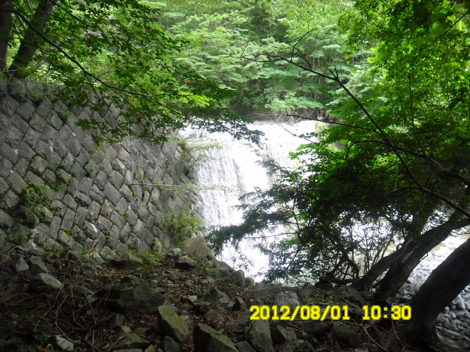
[Mudslide-control dam near "Gora-Deai", ゴーラ沢出会付近の砂防ダム、『고라 데아이(골짜기만남)』부근의 사방댐]
鎖場を過ぎて、展望台付近で11時半。ここでお握りを2個食べて昼食とした。曇っていたせいもあるか、展望はほとんどなかった。だが、足元を見るとコケ類やらキノコがきれいだ。

[Some rocky places facilitated with chains, 鎖場もあった。쇠사슬장도 있었다.]

[There were mosses and mushrooms here and there, コケ類、キノコ類があちこちに見える、이끼류, 버섯류가 이쪽저쪽으로 보인다]

登山者にはほとんど会わない。頂上付近でトレイルマラソン中の男性一人、及び4人パーティに会ったのみ。代わりにかわいい生き物、『コガネムシ(黄金虫)』を見つけた。

["Mimela splendens" or "gold-bug", 『コガネムシ(黄金虫)』、풍뎅이]
また、頂上に近づくにつれ、木々がまばらになり、陽射しがよく地面に当たる分だけ、野草の種類も増えてきたようだ。特に目についたのはピンクがきれいなシモツケソウで、この花は頂上付近からこの後の尾根伝いにまさしく「満開」だった。

["Shimotsukeso" or a kind of "Filipendula multijuga", シモツケソウ(下野草)、"시모쯔케소" in Japan]

[A guide-post saying 800 meters up to the top of the mountain, 頂上まであと800mという道標、정상까지 800m이라고 하는 이정표]
頂上付近は木道がよく整備されていて、ツワブキのようなマルバダケブキ(丸葉岳蕗)の山吹色の花があちこちに咲いていた。またその花の蜜をもとめてきれいな蝶(アサギマダラ)が多数、舞っていた。

[Wooden trails near the top, 頂上付近の木道、정상부근의 나무길]

[Buds of "Leopard plants", マルバダケブキの蕾、마루바다케부키의 봉오리]

[Clusters of“Marubadakebuki" or "leopard plant", マルバダケブキ(丸葉岳蕗)の群落、『마루바다 케부키』꽃의 군락]

このアサギマダラはあまりにも熱心に蜜を吸っていたため、接写どころか、指で捉えてしまった。写真を撮り終えて離すとなにごともなかったように優雅に舞って飛んで行った。

[“The Chestnut Tiger” and "Leopard Plant”、マルバダケブキの花に止まった『アサギマダラ』、『마루바다케부키』 꽃에 멈춘 『아사기마다라(왕나비)』]


アサギマダラは長距離を移動する蝶として知られており、日本本島と台湾や南西諸島など1500kmも離れた洋上を飛来するという。
アサギマダラ(ウィキペディア)
http://ja.wikipedia.org/wiki/%E3%82%A2%E3%82%B5%E3%82%AE%E3%83%9E%E3%83%80%E3%83%A9
この美しく小さな蝶のどこにそんなエネルギーが秘められているのか、不思議である。
また、木道に挟まれた太いブナの木には大きな洞があり、大人数人が入れるほどだった。

[A big tree with a big hole, 大きな洞のある木、큰 구멍이 있는 나무]

檜洞丸頂上には1時半過ぎに到着。樹木がさほど密生しておらず、風通しが良く気持ちよい。上りには4時間かかったことになる。
檜洞丸からの下山には険しいので気を受けなさいと言う注意書きが立てられていた犬越路コースを使った。

[Chains facilitated cliff on ridge, 尾根の鎖場、산등성이의 쇠사슬장]
実際、この下りは鎖場やガレ場が多く、やや注意を要する。しかし、シモツケソウがあちこちで満開ですばらしかった。

[The cluster of "Shimotsukeso" or a kind of "Filipendula multijuga", シモツケソウ(下野草)の群落、"시모쯔케소" 의 군락]

また、めずらしいところではタマガワホトトギスを3カ所ほどでみつけ一人でご満悦。


犬越路には15時30分に到着。ここから用木沢出会まで2.5km、さらに自然教室まで1.8kmだから、4km以上歩かねばならない。
15:40のバスどころか17:05発のバスに間に合うかどうか心配になるほどだった。ここからは気持ちも急いで早足で下った。
用木沢ではイワタバコをみつけ嬉しくなった。自然教室には16:50に到着。かろうじて職員の人にタマガワホトトギスなどの花の名前を教えてもらう時間があった。

["Hototogisu (Lesser Cuckoo)" or "Toad Lily", ホトトギス(杜鵑草), 『호토토기수』]

ちなみに和名の「ホトトギス」は花弁にある斑点が鳥のホトトギスのお腹にあるものに似ているところからそう呼ばれるようになったそうだ。

[A stream in the valley and "Iwatabako" flowers, 渓流とイワタバコの花、계곡물과 "이와타바코" 꽃]

個人的には英語の”Toad Lily”(ヒキガエルの百合)より、和名の「ホトトギス」のほうが好きだ。
復路は小田急でもどったため、大船に着いたのは8時過ぎだった。東京方面から来るハイカーには小田急が便利で料金も安価であると思われる。
ハイキングの所要時間はほぼ7時間で、花と蝶々を堪能した快適な一人登山だった。(この夏の帰国中に登った4つ目の山である。)
0 件のコメント:
コメントを投稿