Hiking Date: May 18, 2013 (Sat) Fine, then cloudy, later at night, rain
Destination (mountain): Mt. Jiri (Jeonra-do & GyongNami-do))
Hiking course: Seogsamje – NoGoDan – Dwaejiryong – Norumok – DamDoBong – ToKkiBong – MyongSeonBong – Yonhacheon Shelter – HyongJeBong – ByokSoRyong Shelter - DeokPyongBong – JilSeonBong - YongSinBong – SeSeokDae Shelter – GeoRim Bus Stop – JungSanRi Parking Lot (About 32 km)
Partner: 17 AhToSan members
AhToSan planned the traversal of Mt. Jiri. Jeongjeong, one of the staff members, planned this long hike for me, since this is my last summer in Korea.
Total hiking distance is over 30 km, so only strong hikers could apply for this hike. Jeongjeong was kind enough to walk with me from the beginning to the end, so I would never be lost during this hike.
The bus left at 11 pm on Friday. AhToSan chartered a micro-bus with 20 seats, not the regular big size bus. I sat the back seat which turned out to be the worst seat because I could not recline the seat.
The man in front of me reclined his seat up to the largest angle, so I had very little space for my legs. I also felt much jolts because it was the back-end position. Therefore I could not sleep at all.
However, we arrived at SeongSamJe, the starting point for the long hike at 2:30 am. The gate for the trail was open at 3 am. I hurried to walk ahead as the top among all hikers, until for 5 minutes. 10 minutes later, all AhToSan members got ahead of me!
Anyhow I could manage to arrive at NoGoDan Shelter at 3:36 am. All AhToSan hikers were waiting for me.
It was clear that night and I could see many stars in the sky and many constellations such as the Great Bear, Cassiopeia, Scorpius and the Milky Way, etc.
We had “Suzuki Time” at NoGoDan Pass, so my bag became a little lighter.
The trail from NoGoDan Pass to Doaejiryong was many rocks and difficult to walk. My flashlight became weak because the batteries worn out. Then one of fellow hikers, Tazan, offered his spare light to me. I borrowed it with thanks and it was a great help for me.
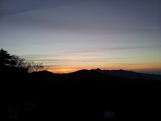
It became dawn before I reached at Dwaejiryong. Jeongjeong walked with me so that I would not be lost. Other hikers must be at DamDoDong and could see nice sunrise, I thought. I felt sorry for her.
I arrived at SamDobong at 6:06. Other members were already having breakfast there. So Jeongjeong and I joined them.
They gave me two packs of bento which were sticky rice with red beans. I ate one of them and one of toast sandwich I made previous night. I also offered a Japanese can beer (Asahi, 500cc) to my fellow hikers.
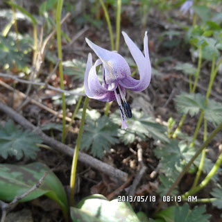
After having breakfast, I could enjoy ridge hike. There were many beautiful flowers, especially fawn liliy (or trout lily, dog's-tooth violet, etc.) This flower is called "Yeolleji 얼레지" in Korean and native to Japan, Korea and northeastern China. And I Korea, I saw many in Mt. Jiri.
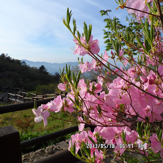
Besides “Yeolleji” there were many “Jindallae" or “Korean rhododendron” and “Sancheoljjuk” or “Royal azalea.”
Usually “Jindallae” blooms early spring and “Sancheoljjuk” booms in May, but at JiRiSan, they bloom at the same time.
I arrived at ToKkiBong at 7:36. The president of AhToSan and J-nim and those who were ahead of me, were waiting for me and encouraged me.
“Kkachi” seemed very sleepy and he was taking nap at the side of the trail. Jeongjeong also said, “Oh, I am sleepy” several times. So it was not only I who could not sleep last night.
Actually Jeongjeong stumbled behind me and laughed at herself. She seemed to sleep while walking!
There was a nice facilitated trail with wooden stairs. I saw a rather big cherry tree, and cherry blossoms were in full bloom.
We arrived at YonHaCheon Shelter at 9:06 am. There was a water-supply place, and clean toilet. I joined the middle group and took several pictures with them.
There were beautiful yellow flowers which reminded me of “Ryukinka” or “kingcup/marsh marigold” around here.
I arrived at HyongJeBong at 10:10. Some of AhToSan members were waiting for me. They climbed HyongJe Bawui, which means “Brothers Rock.” I also climbed this rock.
There were many beautiful flowers including “Cat’s Eye” which I saw several years ago at Mt. Jiri. I have never seen that flower since then. I found this flower at the same place when I saw it before. This time, I saw many of this flower along the trail.
We arrived at ByongSoRyong Shelter at 11 am. There were nice tables and benches in front of the shelter, so we decided to have lunch there.
I had the 2nd pack of the rice with red beans and another can of beer and sandwiches. While we were having lunch, there was a big sound of “Bang!” just next to our table. It was a gas-explosion of cooking burner which our neighbors were using.
Their cooking utensil was blown away and a hiker got injured by the blast in his arm. Fortunately it was not serious, so they wrapped his arm and that’s it. The lesson is that we should be careful when we use gas and fire.
From ByongSoRyong Shelter to SeSeokDae Shelter, the last leg of the ridge walking, I really enjoyed the beautiy of “Jindallae”flowers. These “Jindallae” are different from ordinary “Jindallae” but they were “Tol Jindalllae” special kind which broom in high land.
When I went through the tunnels of “Jindalle” passing YongShinBong, I happened to see an old AhToSan member who was carrying heavy bag on her.
Her nickname is “Lion.”She was a strong female hike like “Jeongjeong.” She used to be a hiking leader of AhToSan.
Anyway, I have not seen her for a couple of years. But I remember her “nick name.”So I called her and she recognized me, too.
Jeongjeong was also glad to see Lion, so they stopped and began a long chatting. I took their pictures and went ahead.
When I arrived at Seseok Shelter, Jeongjeong caught me up. At this point it was 2:40 am. I thought it was too late to head for CheonWangBong, which required 12 km more, so I decided to go down from the mountain.
Jeongjeong accompanied with me. We began descending the mountain and headed for GeoRim village. It was about 6 km from Seseok Shelter.
[SeSeokDae Shelter, セソクデ待避所、세석대 대피소]
There was a bus service available from GeoRim to JungSanRi, the final destination, and it was 4:50 bus. We had to hurry to reach at the bus stop at GeoRim at 4:50. Actually, we almost ran for 6 km.
We could not take the bus, anyway, but Jeongjeong called a taxi. We went to JunSanRi from GeoRim by taxi and it was just 5 pm we arrived at the final destination.
The most of hikers arrived at the final destination at 6 pm when those who came earlier were having supper at a restaurant. But one person “Kkachi” did not come down even at 8 pm.
We went to the exit of the trail by micro-bus, and Jeongjeong went into the mountain to support the last hiker.
They finally came to the bus at 9 pm, then we headed for Daejeon. We came back to Daejeon at 11:40. I returned to my studio apartment after midnight. A little bit tired, but I am satisfied with what I had done: more than 30 km hiking successfully.
It was my 23rd hike for this year and my 314th hike as AhToSan regular hike.
--------------------------------------------------------------------------------------------------------
分類:登山、韓国、春山「智異山縦走」
登山月日:2013年5月18日晴れ後曇り、夜雨
登山地:智異山縦走(老姑壇~三道峰~天王峰)
登山コース:ソンサムジェ(성삼제)-老姑壇(노고단)退避所-老姑壇峠-テジ領(돼지령)-1424峰(H)-イムギル領(임길령1320m)-ノルモク(노루목1500m)-三道峰(삼도봉1550m)-トッキ峰(토끼봉1537m)-木の階段-ミョンソン峰(명선봉1586m)-ヨンハチョン(연하천)待避所-兄弟峰(형제봉1537m)-兄弟岩-ピョクソリョン(벽소령)待避所-トクピョン峰(덕평봉)-チルソン峰(질선봉)-長い階段-ヨンシン峰(영신봉)-セソクデ(세석대)待避所(23km)-------(下山路:6km)------コリム売標所(거림매표소)-(1km)-コリム(거림)バス停~タクシー~中山里(중산리)駐車場(歩行距離約32km)
同行者:アトサン会員17名
今回は韓国の名山中の名山、智異山の縦走で、その距離は30kmを超えるため、参加者はわずか18人と少人数だった。そのためアトサンは20人乗りのマイクロバスを利用した。
私は一番後ろの席に座ったがこれは大失敗。一番後ろはリクライニングができない上、直前に座った人間が目いっぱい、リクライニングを倒したため、不便この上もない。また、振動が激しく、一睡もできなかった。
南門出発は金曜夜の11時で、バスは2時半にソンサムジェに到着。2:38には外へ出た。ゲート前で集合写真撮影後、3時きっかりに入山した。
まっさきに飛び出し最初の5分間だけ先頭を歩いた。しかし5分後に先頭集団に追い抜かれ、10分後にはアトサン全員に抜かされた。それでも老姑壇退避所に3時36分、老姑壇峠には3時50分に到着した。
ここまで見上げると満点の星空で、カシオペアや大熊座、さそり座、天の川が良く見えた。ここで1回目の休憩でフルーツを食べてもらった。
このころ持参したライトの電池が消耗して暗くなった。ここから夜が明ける5時ごろにかけて足場の悪い登山路で困ったが、バス内で隣に座った新人(別名ターザン)が私に予備のライトを貸してくれて大いに助かった。ライトの点検は事前準備で重要事項の一つだということを改めて認識した。
テジリョンの手前で夜が明けて来て私に同行してくれたチョンジョンがいまごろ日の出だと語った。私にかまわずに進めばたぶん三道峰(삼도봉1550m)ですばらしい日の出が見えただろうに申し訳ないと思う。
三道峰に着いたのは6時6分で、認証写真を撮ってから朝食のグループに加わった。バス内で配られた2個のお赤飯の1つとサンドイッチ1個食べた。また、重いのでビールの500cc缶を提供した。
三道峰の朝食後は朝霧に浮かぶ智異山の峰々と足元の花々を楽しんだ。智異山はカタクリの群落が多い。また、チンダルレとサンチョルチュクが同時に咲いている。
トッキ峰(토끼봉1537m)には7時36分に到着した。トッキ峰では先行していたアランドロン会長やJニムたちが待っていてくれて、励ましてくれた。
カッチはひどく眠いらしく、10分ほど道端で眠ったようだ。また、チョンジョンも「眠い」を連発し、私のすぐ後ろを歩いていて転んでしまった。幸い怪我はなかったようだ。寝不足は私だけではない。
途中良く整備された木の階段もあり、八重桜の大木には桜が満開だった。ヨンハチョン(연하천)待避所には9時6分に到着。ここでは飲み水も補給でき、きれいなトイレも完備していた。
また、アトサンの中間隊のアランドロン会長、民主、Jニムらが待っていて合流して写真を撮った。
あざやかな黄色いリュウキンカのような黄色い花も多く咲いていた。なんといってもカタクリの群落がすばらしい。
兄弟岩には10時10分到着。ここでは私を含めて7、8人ほどいて、岩の上に登って写真を撮ったりした。
この後、高山のキジムシロが見事に咲いていて、この花も撮影した。また、だいぶ前に一度だけみた「ネコノメソウ」とかいう珍しい花も群落で発見。ハッピーな気分になった。
碧宵嶺(벽소령ピョクソリョン)待避所には11時に到着。ここの大きめのテーブルを1つ占領して昼食にした。
ところが食事のまっさかりに隣のテーブルでガスが風にあおられて白煙と共に爆発し、鍋がふっとんで一人が腕に傷を負う事故が発生した。大事にいたらなかったことは不幸中の幸いだが、火を使う時は十分注意をしなければいけない。
今回の縦走では、この碧宵嶺待避所での風が一番強く寒かった。食事は30分ほどで、弁当の残りの1個とサンドイッチを食べた。
Jニムがジョニウォーカーの青を提供したが、私は遠慮して味わえなかった。民主は2杯3杯と空けたが彼女は実に豪傑だ。
碧宵嶺待避所を後にしたコースは次第にチンダルレとサンチョルチュクの密度が増した。尾根は見晴らしが良いがこのころから空は一面の雲で太陽の陽射しが遮られ、登山には最適だ。
天王峰は雲とすれすれの高さで頂上が少し雲に隠れる程度で風情がある。
みごとなチンダルレの群落を楽しみつつ、ヨンシン峰(영신봉)には午後2時20分に到着。チンダルレのトンネルを抜けてセソク待避所へ下りようとしたところで思わぬハイカーに出会った。
前方からすごい荷物を背負った女性が以前アトサンで山行大将を務めた「ライオン」によく似ていると思ったら、彼女だった。
チョンジョンも大喜びで二人の出会いの写真を何枚も撮影した。話も尽きないようでしばし立ち話をしていたが、私は先にセソク待避所へ下った。
この時点で2時40分だったが、チョンジョンがトイレへ行き、また水場で顔を洗ったりしていたのでここを出発したのは2時50分。
ここから先の天王峰に至る登山はあきらめ、コリム・マウル(村)へ出る下山路を選択した。チョンジョンが地図に書いたバスの時刻表では午後4時50分。このバスに間に合わせようと6キロを飛ぶように下った。
実際、勾配もあるし、岩がごろごろしていて油断がならない下山路だが、必死で下った。前を行くハイカーを何人も追い抜いてコリムへ着いたのは4時30分。
しかしバス停はさらに舗装道路を1~2キロ下らねばならない。だが、チョンジョンは4時50分のバスはなくなったという。
彼女はバス停の近くでコールタクシーを呼び、結局タクシーに乗って中山里へ着いたのはちょうど5時だった。
この時点で夫婦ものとカッチの息子が先にコリムからタクシーで下山しており、またスーパーハイカーの三人がフルコースを下山してマッコリで一杯やっていた。
夫婦とカッチの息子と私はマイクロバス内で1時間待機。6時過ぎにアランドロンや民主、ややおくれてJニムが下山した。
運転手用の食堂(キサシクタン)でパジョンとマッコリ、およびビビンパプを食べた。7時すぎに遅れた三人組が下山したが、カッチ一人がひざの故障で下山に苦労し、結局登山口までバスで行き、チョンジョンとラブがカッチを迎えに行った。
三人がバスに到着したのは9時過ぎだった。大田には11時40分ごろ到着。ワンルームには12時過ぎに到着した。
途中の休憩所から降り始めた雨は幸い小ぶりで自転車で帰るには支障がなかった。マイクロバスによる往復はつらかったが、登山そのものは充実したハイキングであった。
2013年に23回目の登山であり、アトサンの通算定期登山の参加回数は314目である。
また、1日に30キロを超える登山は今回が初めてで、歩き通したことに自信を持った。
I like hiking very much. I used to go hiking with a Korean hiking club named “AhToSan.” This blog introduces mostly my hiking activities in Korea and Japan, and Sydney in Australia. As of January 2020, I live in Sydney suburb. I go Blue Mountains and bush walk in Sydney area. 私は2003年から2014年まで韓国の大田(テジョン)に住んだ日本人である。11年間、週末は主に「アトサン山岳会」に参加した。14年4月に帰国したが、2020年以降はおもにシドニーで暮らし、時折、日本へ帰国する程度である。したがって最近の記事はSR(Sydney Report)としてブルーマウンテンのトレッキングを中心に書いている。
About pictures/当ブログ内の写真について/당 블로그내의 사진에 대해서
Most of the pictures in this blog are taken by my camera, yet some of them were downloaded from the website of the hiking club. If you click any pictures, they become the original size.
当ブログ内の写真の大部分は筆者のカメラで撮影したものですが、一部、山岳会の共有写真からダウンロードしたものを含みます。すべて、各写真をクリックすれば、元のサイズに拡大します。
당 블로그내 사진의 대부분은 필자의 카메라로 촬영한 것입니다만 일부 산악회 공유 사진으로부터 다운한 것도 포함합니다. 모두 각 사진을 클릭하면, 원래 사이즈에 확대합니다.
当ブログ内の写真の大部分は筆者のカメラで撮影したものですが、一部、山岳会の共有写真からダウンロードしたものを含みます。すべて、各写真をクリックすれば、元のサイズに拡大します。
당 블로그내 사진의 대부분은 필자의 카메라로 촬영한 것입니다만 일부 산악회 공유 사진으로부터 다운한 것도 포함합니다. 모두 각 사진을 클릭하면, 원래 사이즈에 확대합니다.


0 件のコメント:
コメントを投稿