Destination (mountain): SoMaeMulDo, Geoje, GyongNam Province
Hiking course: Port – Village – Abandoned School – MangDaeBong – Sea-Route – Lighthouse Island (Round trip) Partner: 41 AhToSan members (Including Eric)
AhToSan visited this island on November 21, 2009. At that time, 9 Taejonhikers joined the trip, including an Israel couple. But this time, only Eric joined us.
The AhToSan bus left at South Gate at 6:20 am, and we arrived at Geoje Port at 10:30. The boat bounding for the island left at 11 am and arrived at the island at 12:10.

[The 1st group picture at Geoje Port, 巨済港で最初の集合写真、거제항에서 첫 번째 단체 사진]
The wind was very strong, so it was cold on the deck. Last time, we had a drinking party on the deck, but this time, we all took seats in the cabin.

[AhToSan members in the cabin, 連絡船の船室内のアトサン会員たち、연락선 선실내의 아토산 회원들]
After taking a group picture at the port, we began climbing the steep slope toward MangDaeBong (152m).

[Shouting "Let's go mountain on Saturday!" 出発前の掛け声『あ~土曜日は山へ行くぞ!』、출발 전 구호 "아! 토요일은 산에 가자!"]
There was an abandoned elementary school on the ridge. We could enter the ground and the building last time, but it was completely closed at the gate. I saw a stone plate at the gate on which the rocord of the school was written (open in 1961 and closed in 1996).
Passing by the abandoned school, we stopped on a ridge from where we could see nice views of the other side of the island.
Then we climbed a little and arrived at the top of MangDaeBong. There was a while building on the top of the mountain.

[Lunch at the top of MangDaeBong, 望台峰頂上で昼食、망대봉 정상에서 점심]
It was “MaeMulDo Tariff History Museum.”There was a bronze statute of an officer in front of the building.

[Eric in front of "Customs Duty History Museum", 毎勿島関税歴史館の前で、매물도 관세 역사관 앞에서]
We decided to have lunch there. About half of AhToSan participants had lunch together.
Then we descended from the mountain toward “Lighthouse Island.”
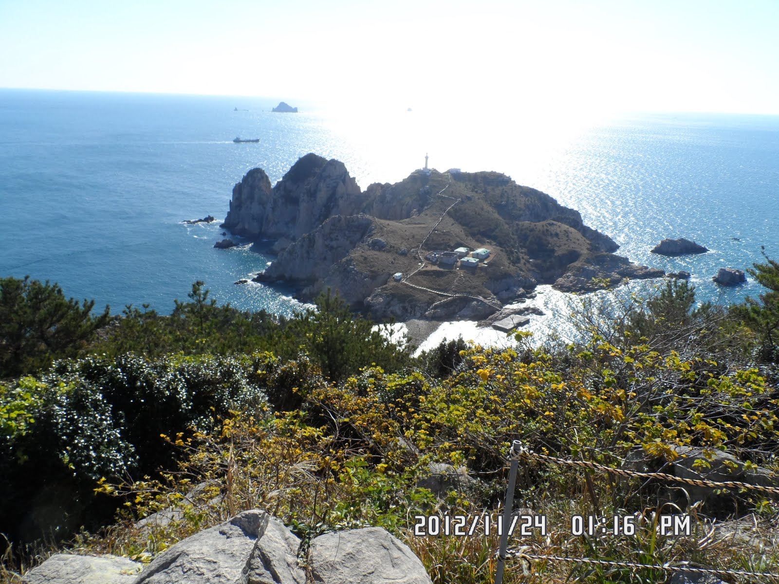
[The view of "Lighthouse Island" from MangDaeBong, 望台峰から『灯台島』を望む、망대봉에서 "등대 섬"을 바라본다.]

Last time (3 years ago), it was too late to walk across the sea-trail, but this time, we could walk on the rocks to the island.

[At the beach of SoMaeMulDo, 小毎勿島の海岸にて、소매 물도 해안에서]
Eric and I walked across the sea and walked toward the lighthouse on the island, but we met some members of AhToSan who warned us to hurry, otherwise the tide would be too high to return to the main island.

[The lighthouse on the Lighthouse Island, 灯台島の灯台、등대섬의 등대]
We hurried back to SoMaeMulDo through the trail in the sea.

[The trail in the sea from Lighthouse Island, 灯台島より『海の道』方面を望む、등대섬에서 '바닷길'방면을 바라본다.]
We had a short break on the cliff of SoMaeMulDo. We could enjoy fantastic views from the observatory.

[Viewing Lighthouse Island at Observatory, 展望台より灯台島を望む、전망대에서 등대 섬을 바라본다.]
When we came close to the habor, it was still before 3 pm, so we walked around the island called “Lighthouse Trail.”

[The gate of "Lighthouse Trail",「小毎勿島灯台道」のゲート、"소매물도 등대길"문]

[Chrysanthemum boreale Makino, キクタニギク(別名アワコガネギク), 산국]

[A view from Lighthouse Trail, 灯台道からの展望、등대길에서의 전망]

[Camellia flowers at Lighthouse Trail, 灯台道に咲いていたツバキの花、등대길에 피어 있던 동백꽃 ]
We could see the peninsula side well from the trail. Again we met a group of AhToSan who went first to the senic place. They warned us not to be too late. So we returned to the habor from a sea-shore on the way to “Nanmae Rock”. It was still 3:10 am.
The boat came to the island a little past 4 pm and we returned to Geoje Part by 5:10.

[The boat was approaching toward the island, 小毎勿島に近づきつつある連絡船、소매물도에 가까워지고있는 연락선.]
We had a wrap-up party at the same restaurant we had 3 years ago.

[The sunset in the sea, 閑麗海上国立公園の日没、한려 해상 국립 공원의 일몰]
The main dish was “Sashimi” and “Maeuntang”. We enjoyed the food and party until 6:30 and came back to Daejeon at around 10 pm.

[Wrap-up Party at Sashimi Restaurant at Geoje, 巨済の刺身屋で打ち上げ、거제 횟집에서 뒤풀이]

This was my 59th hike for this year and 297th time regular hike with AhToSan.
-----------------------------------------------------------------------------------------
韓国の島登山:閑麗海上国立公園の小毎勿島(ソメムルド)
登山月日:2012年11月24日(土)快晴
登山地:慶南・巨済の小毎勿島(ソメムルド)
登山コース:小毎勿島港〜村〜廃校〜望台峰(マンテボン망대봉海抜152m)〜海の道〜灯台島(往復)
同行者:アトサン会員41名(外国人は中国人のエリックと私だけ)
アトサン山岳会はこの小毎勿島(ソメムルド)に3年前の2009年11月21日に訪れている。
この時はイスラエルの夫婦(Mr. &Mrs. Sthub)らを始め、トレイシーやベルナルド、ソーメン、ドミトリー、ピーターなどテジョンハイカーズのメンバーが9人も参加しているが、今回は私とエリックのみだ。
南門出発時間は連絡船の出航時刻にあわせて6時20分。3週間ぶりにエリックが私の隣に座った。途中2回休憩し、巨済港に着いたのは10時30分だった。

[The 1st group picture at Geoje Port, 巨済港で最初の集合写真、거제항에서 첫 번째 단체 사진]
巨済港で最初の集合写真を撮り、連絡船に乗船した。前回は甲板で酒盛りをしたが、今回はとても寒くて甲板には出ず、コッピやエリックとともに1回の船室の座席に座った。船は途中2カ所に寄港し、終点の小毎勿島に到着して2度目の集合写真を撮ったのは12:13だった。

[AhToSan members are landing on the island, 島に上陸するアトサン会員たち、아토산 회원들이 섬에 상륙하고있다.]

[The second group picture at SoMaeMulDo Port, 小毎勿島の船着場で2度目の集合写真、소매물도 선착장에서 두 번째 단체 사진]

[Shouting "Let's go mountain on Saturday!" 出発前の掛け声『あ~土曜日は山へ行くぞ!』、출발 전 구호 "아! 토요일은 산에 가자!"]
前回は、すぐに灯台島に向かわず、男妹岩の方へ寄り道し、昼食を摂ってから灯台島へ向かったので、引き潮時間帯が過ぎてしまった。今回はそのようなことがないように、男妹岩(ナンメパウィ)方面を後回しにした。
3年前は建設中だったペンションがほぼ皆完成したようで、なかなかの壮観だ。小毎勿島の住民は約20世帯ほどで、港付近に集中している。
村の後ろの望台峰に続く急坂を登り切ると廃校跡になるが、3年前は見学で来た廃校が、現在は完全に封鎖されて、グラウンドにも校舎には入ることはできない。毎勿島小学校は1961/4/29に開校し、1996/3/1に廃校になったと記された石碑が封鎖された校門の前にあったのに気が付いた。

[Stone monument of the abandoned school, 廃校の歴史が記された石碑、폐교의 역사가 기록 된 비석]
廃校から望台峰へいたる尾根には椿の木が多く見られ、港と反対側の海の風景が望める。望台峰の頂上には前回建設中だったドームが完成されていて「毎勿島関税歴史館」になっていた。

[Lunch at the top of MangDaeBong, 望台峰頂上で昼食、망대봉 정상에서 점심]
ドームの中は資料館になっており「真っ青な波、ひっそりとした楽土に関税船を守る経済国防軍!彼らがここにいた。」と歌う「関税歌」の音符と歌詞が展示されていたのは面白いと思った。

[Eric in front of "Customs Duty History Museum", 毎勿島関税歴史館の前で、매물도 관세 역사관 앞에서]
アトサンの本隊は望台峰の頂上で昼食を摂った。また、展示館の前には関税官らしい制服を着た人が灯台島の方を指さしているブロンズ像が立っていた。
昼食後、灯台島を前方に見ながら急な階段を下ると岩と石だらけの海岸に出た。前回はこの時すでに満ち潮が始まっていて、灯台島に渡ることができなかった。今回は「海の道」がしっかりと現れていて、エリックと私は連れだって灯台島に渡った。

[At the beach of SoMaeMulDo, 小毎勿島の海岸にて、소매 물도 해안에서]

灯台島にはトイレもできていて、さっそく利用したが、先発隊が灯台島の見学を終えて降りてくるのに出会った。彼らによると満ち潮が始まっているから急いで当代島の見学を済ませて小毎勿島へ戻った方がいいと言われた。そこで、灯台の下までは行かずに途中で引き返した。この時点で1時50分。

[The lighthouse on the Lighthouse Island, 灯台島の灯台、등대섬의 등대]
復路では海岸から階段を上った稜線の展望台で小休止した。ここで、午前中に出しそびれたブドウとトマトを出したが、周囲の会員の数が少なくて半分も減らなかった。展望台では数枚写真を撮って、ふたたび望台峰の方向へ戻った。

[Viewing Lighthouse Island at Observatory, 展望台より灯台島を望む、전망대에서 등대 섬을 바라본다.]
廃校まで戻った時刻は2時半で、港での集合時間まで1時間余裕があったので、エリックとともに男妹岩方面へ向かった。この島を緩やかにめぐる道には立派な門ができていて「小毎勿島灯台道」と銘打っていた。

[The gate of "Lighthouse Trail",「小毎勿島灯台道」のゲート、"소매물도 등대길"문]

[Chrysanthemum boreale Makino, キクタニギク(別名アワコガネギク), 산국]

[A view from Lighthouse Trail, 灯台道からの展望、등대길에서의 전망]

[Camellia flowers at Lighthouse Trail, 灯台道に咲いていたツバキの花、등대길에 피어 있던 동백꽃 ]
このトレッキング・ロードでも先発隊が見学を終えて戻ってくるのに出会った。3時半までに港に戻るため、男妹岩までは行かず、途中の海岸で引き返した。港に戻ったのは3時10分ごろだった。

[The boat was approaching toward the island, 小毎勿島に近づきつつある連絡船、소매물도에 가까워지고있는 연락선.]
4時に出港する予定の船は到着が少し遅れて4時15分ごろだった。復路は往路より波も穏やかだったようで、5時10分には巨済港に着いた。3年前と同じ港に面した刺身やで豪華な打ち上げを行った。


0 件のコメント:
コメントを投稿