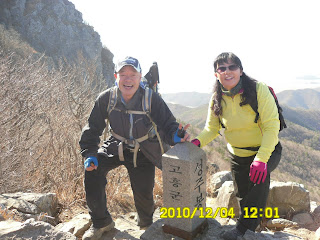
Place: Palyongsan (608m), Goheung, JeonNam Province
Course: Neunggasa (Temple) – Palyongsanjan – Heungdeulbawui (Rocking Rock) – 1st peak --- 8th peak – Tapjae - Neunggasa – Parking Lot: 9 km (5-hour hike)
Partners: 25 members (No foreginers, except me)
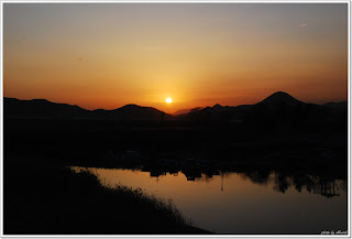
 [The shadow of Mt. Palyongsan、八影山の山影、팔영산 산그늘]
 This time again, since we go to the southern tip of the peninsula, we left Deajeon 1 hour earlier than usual, 6 a.m.
On the way to the place, there was a 50-time award ceremony. “Wupo” which means “a bundle of laughter” received the award.
 [Wupo-nim, 50th AhToSan Hiking Award, ウポさん、アトサン50回達成表彰、붓보님, 아토산 50회 달성 표창]
She is a short lady, yet a very good hiker. She is also a good modle for many photographers. Many members love her laughter.
“Yoregi” is another source of providing “handmade” food. This time, she brought “ssuk-ttok” or grass-mixed cake. It is said that she got up at 3 a.m. and made them for AhTo-members.
 [rice cake seasoned with mugwort, ヨレジさんの作った草餅、여래지님이 만든 쑥떡]
 We arrived at the parking lot of Neugasa Temple at 10:30. After taking the group picture in front of the temple, we began hiking.
 [A group picture in front of Neugasa, 楞伽寺の前で団体写真、느가사앞에서 단체사진]
 On the way, there was a big plate which shows each name of “Palyongsan” and their heights.
 [Rocket like road sign,ロケットの形をした道標、로켓형을 한 도로 표지]
Actually there are 9 peaks. So 8 plus one is correct. The last one is called “Gittaebong” and this peak is the highest among all. “Gittae” means “flagpole” so it has a long flag of 8 peaks.
When we walked for about 30 minutes, we came to a big rock called “Heungdeulpawi” which means “Rocking rock.” There was a gazebo near this rock. So we had “Suzuki Time” rest. I have brought fruits and 2 bottles of chestnut makgeolli. They liked them all.
 [I push "Rock'n Rock", フンドルパウィを押す、흔들 바위를 무릅쓴다]
 When we walked for 30 more minutes, we came to the ridge from which we had good views of other mountains and sea.
 [A view from the ridge, 稜線からのながめ、능선으로부터의 전망]
We arrived at the 1st peak at 11:45. The 2nd peak, at just noon. Then we arrived at the 3rd peak at 12:09.
 [The first peak↑ and the 2nd peak↓、第一峰と第二峰↓、1봉과 2봉]
 [The 3rd peak, 第三峰、3봉]
These peaks are rocky and steep, yet it was fun to climb and down one after another.
We had lunch near the 3rd peak. It was “terrace-like” place on the cliff. So, a bit thrilling.
 [Lunch time, 昼食、ラーメンはニンキメニューだ、점심, 라면은 인기 메뉴다]
I was in the frist group which finished lunch first. We came to the 4th peak at 12:50, the 5th peak at 12:53 and the 6th peak at 13:06.
 [The 4th and 5th peak, 第四および第五峰、4봉과 5봉]
After 6th peak, the defference between the tops and bottoms became rather big. So it took more time than before. I arrived at 7th peak at 13:25 and the 8th peak at 13:52.
 [The 6th peak, 第六峰、6봉]
I was in the first group until the 8th peak. But they were a group of specialists. They tried to climb “Gittaebong” the highest peak. I just tried to follow them, but I lost the sight of them.
So I gave up to be in the specialist group, and just joined the top group of “ordinary hikers.”
The down trail was pleasant and nice. It was not steep nor rocky, just smooth and gentle trail. I like especially the wood of Japanese (hinoki) sypress. They are rate in Korea.
 [The wood of Japanese sypresses, ヒノキの林、노송나무의 숲]
We came down to the Neunggasa Temple as the top group. So, we took pictures leisurely. From the temple, we could see the shadow of Palyongsan very well.
 [At Neunggasa Temple,楞伽寺(ヌガサ)にて、능가사에서]
We came back to the parking lot at 3:20. Then rest of the group came one after another. The last one came back at 4:30 p.m., then, we moved to the special spot called “Suncheon Bay Ecological Park”
http://www.suncheonbay.go.kr/english/html/main/main.jsp
 [Suncheon Bay Ecological Park (Reed field], 順天湾自然公園(葦の原)、순천망 자연공원(갈대밭)]
I certainly rember that I visited this area before with AhToSan people.It is a wide area of wet-land where many migrant birds come and go every year.


We all enjoyed leigurely walk in the park for about one hour, then we left the park at 5:30 there.
We stopped at the parking area called “Shimjingang” and had “Tippuri Party” there. The menu of Tippuri were: boild pork and “odeng” and soju.

We came back to South Gate parking lot at 10 p.m. It was my 57th hike for this year, and the 222nd hike with AhToSan as total.
日時:2010年12月4日(土) 快晴。
登山場所:全南・高興(コフン고흥)の八影山[パルヨンサン팔영산608m)
コース:登山コース: 楞伽寺(능가사)~八影山荘~フンドルパウィ(흥들바위)~1峰~8峰~タプチェ(탑재)~楞伽寺(ヌガサ능가사)~駐車場:9キロ、5時間
同行者:約25名(外国人は私だけ)
今回も登山地が韓半島南端で遠いため南門6時出発。外国人は私だけ。
バス車内でウポ(笑いの風呂敷)のアトサン50回目のお祝いがあり、車内で記念撮影をした。またヨレジが朝3時起きして作った草餅が配られた。


途中、2度目の休憩は高興の宇宙休憩所。八影山のバス駐車場には10時半に到着した。


駐車場から楞伽寺(ヌガサ)の前で記念撮影をしてから寺の横を通って、八影山野営場を抜け、八影山荘から尾根へ上がる道をたどった。

途中に八影山の各峰々の名称と由来を示す大きな看板があった。八峰の名称や高さは以下の通りだ。
1峰儒影峰(유영봉491m)、
2峰聖主峰(성주봉538m)、
3峰笙篁峰(생황봉564m)、
4峰獅子(사자봉578m)、
5峰五老峰(오로볼596m)、
6峰頭流峰(두류봉596m)、
7峰七星峰(칠성봉598m)、
8峰積翠峰(적취봉591m)
さらに、これら8峰を総括するようにキッテ峰(깃대봉608m)がある。八影山の峰々ではこのキッテ峰が最高峰だ。

さて、出発後30分ほど登ったフンドルパウィ(「揺れる岩」という意味)のチョンジャ(亭子)でスズキタイム。今回は栗マッコリを2本用意し、紙コップなども用意した。大ぶりのパングルトマトも甘い青葡萄も好評ですぐに終わった。
出発から展望の開ける尾根まではちょうど1時間ほどで、それほどきつくはない。

1峰の儒影峰には11:45到着。2峰の聖主峰にはちょうど12時に到着。3峰の笙篁峰はすぐ隣で、12時9分に撮影した。


その後、3峰から一段下りた断崖の上でヨロ、チョンダウン、トワ、金剛らと昼食をとった。昼食時間は約30分。

昼食後は真っ先に出発して4峰の獅子峰には12時50分。5峰の五老峰には12時53分、6峰の頭流峰には13時6分に到着した。


6峰、7峰間、および8峰間はかなりアップダウンが激しく、時間がかかり、7峰の七星峰には13時25分、最後の8峰積翠峰には13時52分に到着した。
 [At the 7th peak,第7峰にて、7봉에서]
ここまで、カッチら、特別先頭グループといっしょだったが、彼らはさらにプラス・アフファのキッテ峰(깃대봉608.6m)を目指すという。私もいっしょに行きかかったが、超先頭グループの影を見失い、少し戻ったところで8峰に着いたチョムワが見えた。

彼ら(チョムワ、チョンダウン、ヨレジ)が本体の先頭であって、彼らと私は当初の予定どおり、キッテ峰には行かず、8峰から各峰の裾野づたいに楞伽寺へもどるコースをとった。
このコースは8峰から下りる部分はやや急こう配だったが、あとはなだらかな下り坂で歩きやすかった。また、途中、韓国では珍しいヒノキの林なぞもあり、気持ち良い下りだった。また、降り切った道には竹林もあった。

八影山荘の先は朝来た野営場で、余裕たっぷり楞伽寺(ヌンガサ)を見学した。境内からは八影山の峰々がよく見え、会員たちの写真を撮った。

駐車場に戻ったのは3時20分だった。今回はここで、ティップリはせず、後尾(フミ)を待って、順天湾の広大な湿地帯に移動した。
この順天湾は以前来たことをはっきり覚えている。とすると八影山も来たのだろうか。それとも別の山だったのだろうか。

ともかく順天湾に到着したのは4時45分で、5時半まで日没の湿原の散歩を楽しんだ。


この後、「シムジンガン(심진강)」のパーキングエリアでウポが用意したティップリをごちそうになった。

スユクとキムチは25人分にしては大量にあったような気がしたが、みな食べた。食べ終わったころ、おでんができ、おでんは食べきれないほどだったが、7時半ごろ、ティップリを切り上げ、帰路に着いた。大田・南門には10時ごろ戻った。
今年57回目、アトサンのトータルでは222回目の登山も楽しかった。
0 件のコメント:
コメントを投稿