Date: Jan. 25 (Sat) 2014, Cloudy, then rain
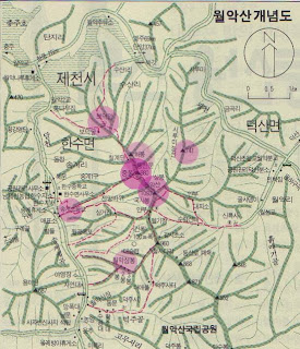
Mountain: Yong-bong(1,097m) in WolAkSan National Park, Jecheon, Chungbuk Province
Hiking Course: Shinreuksa Temple – Shinreuksa Junction – Yongbong – Shinreuksa Junction – “Maaebul”( Buddha image on a cliff) – Parking Lot
The first hike in Korea after my last winter vacation was “WolAkSan.”
It’s one of the 100 Famous Mountains in Korea and a national park.
It is a popular mountain, and AhToSan enjoyed a complete reservation: 45 participants.
It is not far from Daejeon, so we left the regular bus stop at Expo South Gate at 7 am.
We had a breakfast break at Shintanjin Service Area from 7:40 to 8:00.
We arrived at Susanri, the original starting point at 9:40.
I took several group pictures, then the leader called “Ah, Toyoil’n Sanekaja” which means “Let’s go mountains on Saturday.”
Then a man in uniform came to us and told us that the trail we were going, has been closed since the bridge in the trail fell down.
He was a staff member of National Park Management Office. So he led us by his pickup vehicle.
He led us to the parking lot at Shinreuksa Temple.
There was a memorial stone on which the song of WolAkSan was curved.
It was a popular song sang by Ju Hyongmi in 1985.
I used to like songs by Ju Hyongmi late 1980s, but I did not know this song.
Later, I found a website you can listen to this song as follows:
http://blog.daum.net/ayk12032006/2497
As for the temple, there are two “Shinreuksa” temples in Korea. One is in Gyonggido, and the other one is in Jecehon.
Both were built during Shilla period (BC 356 – AD 935). So, it’s a quite old temple.
I went to the temple and saw the 3 layer stone pagoda. It looked very old.
At this moment, I was one of the last hikers among 45 AhToSan members.
It is always difficult for me to walk up to the ridge. This time, it took me more than one hour to reach at the ridge.
About 20 AhToSan members had been waiting for me at the ridge. So, when I arrived and joined them, I could offer the fruits which I brought as usual. It was 11:15.
After having “Suzuki Time,” again I was the last hiker. I followed the group with mostly two members; “Mogwa”, an attractive lady, and “Yugyokdae”a nice gentleman.
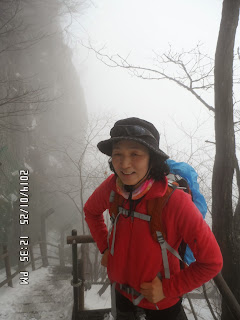
When we arrived at the Shinreuksa Junction, I took pictures of them and “Yugyokdae” took a picture of me.
There was a big pine tree, and the trail was facilitated with wooden plates.
There was a steep steps, then I came to the place where the main group hikers were having lunch.
I joined them. It was after 12:30. It was foggy, but it was not raining yet.
I joined one of the small groups to share lunch.
I finished having lunch before 1 pm and headed for the summit of Yongbong.
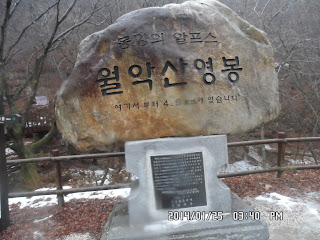
When I arrived at Yongpong, about 5 or 6 members were there. So, I took pictures of the stone memorial with AhToSan members.
Ruchi took my pictures with other members as well.
Then we went back to the Shinreuksa Junction.
It is a junction of three trails. So we began descending the mountain.
While walking down from the mountain, it began raining.
When I came close to the Ma-ae-bul, the image of Buddha curved on the cliff, I quite going to the place and asked other members to take pictures of the image.
When I arrived at the foot of the mountain, it was raining not a little.
I hurried to the parking lot, passing the site of “Deokju Moutain Castle”which must have been rebuilt recently.
When I arrived at the restaurant where AhToSan people were having “wrap-up party”almost all other members were already there.
Anyway, I could enjoy hot soup and makgeolli with them.
We left the restaurant at 4:30 pm and arrived at Daejeon at around 6:30.
It was my 6th hike for this year and 339th AhToSan regular hike in total.
-------------------------------------------------------------------------------------------------------
登山地:忠北、堤川(제천)の月岳山国立公園(월악산 국립 공원)、霊峰(영봉1,097m)、
登山コース:寿山里(수산리)→神勒寺(シンルクサ신륵사)~神勒寺三叉路(신륵사 삼거리) ~ 霊峰(영봉) ~ 神勒寺三叉路 ~ 磨崖佛(마애불) ~ 徳周山城(덕주산성) ~ 駐車場
参加者:参加者:アトサン会員45名
韓国へ戻って最初の登山地は忠北、堤川の月岳山国立公園内、霊峰(1,097m)である。
韓国国立公園管理公団のサイトでは以下のように紹介している。「月岳山は、1984年、17番目の国立公園に指定された。
月岳山は奇岩が聳え立ち、山が険しく、昔から聖なる山と考えられていたことから主峰は霊峰(1.097 m)と名付けられた。
万寿峰、錦繍山、神仙峰、道楽山など、22の大小の山や峰によって構成されている。
忠清北道・堤川市、丹陽郡、忠州市、慶尚北道・聞慶市に接しており、首都圏から近く、忠州湖畔と調和するしているので、訪れる人が年中絶えない。
松林、モンゴリナラ林が多く茂っており、計1,200種の植物が分布している。動物は16種の絶滅危惧種、ほ乳類17種、鳥類67種、昆虫1,092種、両生類10種、は虫類14種、淡水魚27種、底棲無脊椎動物112種、蜘蛛118種が棲息している。」
この日、天候はあいにくの曇り空で気温が高く、残念なことに下山途中では雨が降り出した。
とにかく、残り少ないアトサン定期登山のチャンスで、1回たりともチャンは逃せない。
エキスポ南門の出発時刻は7時で、出発して1時間も経たないうちに新灘津(シンタンジン신탄진)サービスエリアで朝食休憩をとった。
私はワンルームで朝食を済ませているため、配給されたお赤飯は昼食に食べることにした。
当初予定していた出発地点の寿山1里には9:40に到着。
集合写真を撮影して、「ア!トヨイルン、サネカジャ!」の掛け声をかわしたまではよかったが、土地の人が我々に話しかけてきた。
彼の言うには月岳山に登るのなら寿山1里からのコースは途中で橋が落ちていて通行不可だという。
彼は月岳山国立公園管理事務所の人らしく、通行可能な登山口までトラックで案内してくれた。
こちらは神勒寺駐車場からのコースで、バスで到着した時間は10:05だった。
駐車場には立派な「月岳山」の歌碑があり、歌手はトロットの女王「周炫美(チュ・ヒョンミ주현미)である。
周炫美の歌は韓国語の勉強を始めた87年、88年ごろに大ヒットした「雨の永東橋(비내리는 영동교)」や「新沙洞のあの人(신사동 그 사람)」は知っていたが、「月岳山」という歌があったことは知らなかった。
この歌詞に出てくる磨崖仏は高麗時代に彫られたもので高さ13mあるという。この歌が聴けるサイト:
http://blog.daum.net/ayk12032006/2497
駐車場から雪道を少し歩くと右側に「神勒寺(신륵사)」という寺がある。「神勒寺」という名前の寺は京畿道 驪州市(여주시)にもあり、どちらも新羅時代(紀元356年- 935年)の開山となっている。
この寺の中庭にある三層石塔は統一新羅(676年-935年)の時代のもので宝物1296号となっている。
この石塔を見学した時点ですでに私はアトサン45人中の最後尾となってしまったようだ。
いつも尾根にでるまでは苦しい。今回も10時に出発してから1時間15分かかって尾根に到達した。
尾根では20人近くの中間グループが私を待っていてくれた。ここでようやく持参した果物を提供し、「スズキタイム」である。
ここの道標によれば神勒寺まで1.8kmだからそんなに悪くないタイムだと思う。
尾根に出てからはだいぶ楽な気分になった。立派な松を通過して松の根が岩の上をタコの足のように広がっている場所は11:55に通過した。
霊峰への往復地点となる神勒寺三叉路には12:09に到着。ここでは「モグァ」と「遊撃隊」が私を待っていてくれた。また特別に足が速いピアノマンが、すでに霊峰登頂を済ませて下山途中でもあった。
この三叉路の先にも立派な松の木があり、登山路は木道となる。
この先、登山路はかなり急な階段となって霊峰に近づくが、時間が12:30を過ぎ昼食の時間だ。
アトサン本隊が昼食の場所を確保していたところへ合流した。
およそ20人くらいが一緒に昼食をとった。私はJニムやモグァのトッチャリ(ゴザ)に合流した。
午後1時少し前に昼食を終え、霊峰へ向かった。霊峰の石標はまるい石で「月岳山霊峰」とハングルで刻んであり、標高は1097mとなっている。
写真は総務の民主とのツーショットのほか、遊撃隊、チョンジョン、ソルヒャンギ、モグァらアトサンの美女たちとの写真をルチに撮ってもらった。
その後、三叉路にもどったのは1時49分。
あとは渓谷沿いに下ったが、途中で雨が降り出した。徳周寺を目指して下山したが、途中の磨崖仏はアラン大将の撮影に期待して私は通過した。
麓には「月岳山霊峰」とハングルで大きく書かれた岩があり、そこのトイレに入ったころはかなりの降りになってしまった。
この辺りは完全に一人旅となってしまったが、途中、三国時代の遺構といわれる徳周山城の脇を通った。
立派な石の城だが、最近復元されたものなのだろう。
4時を少し過ぎた頃、ようやく打ち上げコンパ会場の食堂に到着した。
メインディッシュは魚と豆腐と野菜のスープで、飲み物はマッコリと焼酎。チョンジョン新会長が「ア、トイイルン、サネカジャ!」と気合をいれていつもの楽しいパーティ。
4時半ごろ切り上げてテジョンへの帰路に着いた。テジョンには6時半ごろ到着。7時過ぎにはワンルームへ戻った。
天候にめぐまれなかったが、今年6回目の登山でアトサンの定期登山は339回目である。
I like hiking very much. I used to go hiking with a Korean hiking club named “AhToSan.” This blog introduces mostly my hiking activities in Korea and Japan, and Sydney in Australia. As of January 2020, I live in Sydney suburb. I go Blue Mountains and bush walk in Sydney area. 私は2003年から2014年まで韓国の大田(テジョン)に住んだ日本人である。11年間、週末は主に「アトサン山岳会」に参加した。14年4月に帰国したが、2020年以降はおもにシドニーで暮らし、時折、日本へ帰国する程度である。したがって最近の記事はSR(Sydney Report)としてブルーマウンテンのトレッキングを中心に書いている。
About pictures/当ブログ内の写真について/당 블로그내의 사진에 대해서
Most of the pictures in this blog are taken by my camera, yet some of them were downloaded from the website of the hiking club. If you click any pictures, they become the original size.
当ブログ内の写真の大部分は筆者のカメラで撮影したものですが、一部、山岳会の共有写真からダウンロードしたものを含みます。すべて、各写真をクリックすれば、元のサイズに拡大します。
당 블로그내 사진의 대부분은 필자의 카메라로 촬영한 것입니다만 일부 산악회 공유 사진으로부터 다운한 것도 포함합니다. 모두 각 사진을 클릭하면, 원래 사이즈에 확대합니다.
当ブログ内の写真の大部分は筆者のカメラで撮影したものですが、一部、山岳会の共有写真からダウンロードしたものを含みます。すべて、各写真をクリックすれば、元のサイズに拡大します。
당 블로그내 사진의 대부분은 필자의 카메라로 촬영한 것입니다만 일부 산악회 공유 사진으로부터 다운한 것도 포함합니다. 모두 각 사진을 클릭하면, 원래 사이즈에 확대합니다.
登録:
コメントの投稿 (Atom)


0 件のコメント:
コメントを投稿