Date: Feb. 8 (Sat), 2014, Cloudy, then snow/rain
Mountain: Gubyongsan (九屏山/구병산876m) in Boeun (報恩/보은), Chungbuk Province (忠北/충북)
Course: Jeokam Service Area – Junction of 3 trail – Spring – Peak of 825m – Wind Cave – Gubyonsan (876m) – Ssalgaebong – Seowonri [11.5 km, 6.5 hours]
After the hike, we took our bus to a restaurant in front of Jeokamri Bus Stop.
Participants: 22 AhToSan members
They originally planned to SeolAkSan, but it had been snow storming since Thursday night, therefore AhToSan staff members decided to change the destination on Friday.
In spite of the sudden change, 22 members applied to the hike to the new destination.
They did not change the bus so, we had plenty of vacant seats which I enjoyed much space on the bus.
Only I worried about the budget of AhToSan. Since they did not change the fee (23,000 won for each participant), it is obvious that they had deficit balance.
They also changed the departure time from 5 am to 7 am. It was much comfortable time.
We stopped at Shintanjin Service Area for breakfast. No matter the number of participants, they provided a pack of redbean rice to each participant. I kept this for my lunch.
We arrived at the starting point of the hike, Jeokam Service Area at 8:40 am.
It was much closer to Daejeon than I expected. So, I did not wear spats on the bus. It took me a little time to do so.
I took the group picture on the bridge without wearing spats.
Then at the entrance of the trail which leads to ChungBuk Alps, there was a big board map of ChungBuk Alps, and a rest room.
While some female members were using the facility, I could put my spats properly, and we took another group picture at the entrance of ChungBuk Alps.
I had difficulties for the uphill as usual. J-nim, a kind staff member of AhToSan kept accompany with me.
It was still 9:25 when “Alain Delon” called for “Suzuki Time” for my sake. So AhToSan members could enjoy eating fruits (grapes and mini-tomatoes) which I carried with me.
They ate about 60% of the fruits, so my bag became a little lighter.
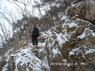
Soon after the “Suzuki Time” break, we came to the rocky part of the trail. I climbed the rock first.
Then I waited for J-nim. When he came up to the rock, we began ridge-hiking, my favorite part of the hike.
I could see villages and roads and reservoir underneath.
A lady whose nickname was “Mindeulle(민들레)” or “dandelion” suggested to wear crampons so I followed her suggestion.
But my feet became heavy because of the climbing irons and snow attached to the crampons.
The snow on the trail was not much, and not frozen at all. So, I took off the crampons and walked carefully. I thought it was much better.
I enjoyed nice views from the ridge while walking toward the summit. Then I caught up with the main group of AhToSan who were having lunch along the trail.
The top group hikers were about to leave the place. But I could join the main group, and could enjoy barbecue which Alain Delon cooked with his burner and frying pan.
“Goodman” who originally came from Jindo, brought “Jindo Red Wine” which was 60 degree of alcohol. I tasted a sip but it was like fire.
After having lunch, I started walking before the main group. The dandelion also began walking before the main group.
There are many pine trees. I noticed that some of the trees have V-shape scars. I understand that these scars were made during World War Ⅱ. Imperial Japanese forces badly needed "oil" and they tried to use pine resin in stead of oil. Therefore these scars were made nearly 70 years ago!
However "Dandelion" and I walked almost at the same pace. But the main group people soon caught up with us at the rocky part.
I offered the rest of fruits to them as the 2nd “Suzuki Time.” We ate them all then.
After the 2nd Suzuki Time, we walked together. Then we came to the spot where there were several “wind caves" or "wind hole.”
The warm wind comes from each hole. I saw the similar “wind hole” at Myokosan(妙高山) in Japan last summer.
As far as I remember, this was my first time to see such “wind hole” in Korea.
A good friend of mine, who used to live in Korea for more than 10 years, Alan England found a good video introducing this "Wind Hole." If you click this site, you see more interesting "show" about wind holes.
https://www.youtube.com/watch?v=6ch_PkttrAc (Youtube video in Korean).
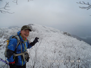
At this moment, the forest were covered with snow, and I saw beautiful hoarfrost on the trees.
I saw a nice shaped tree covered with snow near the summit of Gubyonsan.
Most of us liked this tree very much so we took several pictures of this tree, and people with this tree.
After enjoying magnificient views from the summit, we began descending the mountain.
The trail from the summit to the middle of the mountain was very steep, and I needed put campons again to walk down safely.
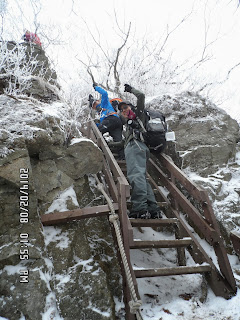
I was again left behind the other members. Then J-nim was waiting for me at the foot of steel ladders.
From the steel ladder to the final point of Sowangri, I walked with J-nim and “Mrs. Dandelion.”
When we arrived at AhToSan bus, it was 3:30 pm. Mr. Park of the bus driver, drove us to a restaurant in front of the Jeokam Bus Stop.
Fast hikers were already having a wrap-up party at the restaurant.
We had a nice party with “Tofu-Jjige” or Korean style stew with tofu and kimchi.
I liked the local makgeolli very much. “Goodman” from sang some folk songs during the party. He has nice voice.
We fully enjoyed the party and came back to Expo South Gate in Daejeon at 6:10.
It was my 8th hike for this year and my 340th AhToSan regular hike.
--------------------------------------------------------------------------------------------------------------------
分類:登山、韓国、冬山
登山日:2014年2月8日(土)曇りのち雪
登山地:忠清北道(충북)、報恩(보은)の九屏山(구병산876m)
登山コース:赤巖SA (적암휴게소) – 九屏山案内板 - 三叉路 (삼거리) - 泉 - 815峰 - 風穴(풍혈) - 九屏山(구병산) – サルケ峰(쌀개봉) – 書院里(ソウォンリ서원리)[11.5km, 6.5時間]
バスで赤巖里バス停前の食堂へ移動、打ち上げコンパ、
参加者:アトサン会員22名
前日、チョンジョン会長から電話があり、雪嶽山地区が豪雪のため、登山地を変更、出発も7時になったと連絡を受けた。
アトサンのサイトには次のように掲示され、参加者は22人に減った。
「 今日(2月7日、金)午後5時現在、束草地域の積雪は8.6 cmに達しており、今日の夜には、よりひどい大雪が予想されています。雪岳山国立公園のフルリムゴル(흘림골)コースは、まだ制御されてはいませんが、大雪のため、明日永同地域は、交通渋滞が予想されています。 アトサンの運営スタッフは明日の気象状況が良くなる可能性がなく、大雪でかなりの交通渋滞が予想される地域で登山を強行するのは望ましくないと考えて山行地を近くの報恩、九屏山に変更することにしました。雪岳山登山を申請していただいた皆さんにお詫びの言葉を申し上げます。」
雪嶽山へ行けないのは残念だが、無理をしては良くない。安全第一に考えるスタッフはますます信頼できる。
参加者が半減したことは残念だが、これも仕方ない。あまり赤字が大きくならないことを願う。
朝7時出発はじつに余裕があってありがたい。朝は昼食用のサンドイッチを作った残りにして、バスで南門へ向かった。
座席は余裕たっぷりで2席を占有できた。朝食は前回に続いて新滩津サービスエリア。私はワンルームで食べたのでパスし、お赤飯は昼食用にした。
新滩津サービスエリアでは、前回気づかなかったシャワールームがあるのに気付いた。なかなよいサービスだと思う。
出発地の赤巖SA(적암휴게소)には8時40分に到着。あまりに早く着きすぎてスパッツを車内で装備する暇もなく、外へ出て、橋の上で集合写真。
橋を渡って登山口にトイレがあり、女性会員が利用している間にようやくスパッツを正しく装着できた。
この登山口は忠北アルプスの出発点になっているので大きな案内板があり、その前でふたたび集合写真を撮った。
この登山口から尾根にあがるまでの1時間が今回もっとも辛い部分だった。
後尾大将のJニムの保護の下、アラン元会長の「スズキタイム」の掛け声がかかったのは9時25分。
ブドウとパングルトマトは約60%がなくなり、荷物が少し軽くなった。
スズキタイムの後、すぐに岩登り部分にさしかかり、ここから数回の岩登りを経て完全に尾根歩きとなる。
尾根の両側に足元の村や道路や貯水池が見え、振り返ると越えてきた峰々が見える。
前を歩いていた夫婦のうち、女性(タンポポ姫)がアイゼンを付けないとあぶないと言うので岩場に登るまえにアイゼンを装着したが、岩には氷はなく、積もったばかりの雪なので実際はアイゼンは不要だった。
むしろ雪と松葉がアイゼンに付着して足が重くなる。30分ほどしてそれに気づき、私はアイゼンを外した。すると足がずっと軽くなり、軽快に登山することができた。
展望の良い尾根歩きを続け、12時過ぎに九屏山の手前で昼食をとっているアトサン本隊に合流した。
ピアノマンら先頭グループはすでに食事を終え、後尾グループと入れかわりに出発した。
山で食べるサムギョクサル焼肉は格別の味がする。
珍島出身のグッドマンが度の強い珍島の紅酒(60度)を持参した。一口飲むと口の中が火のようになる。
昼食後は早めに出発したが、やはり途中で抜かされる。
今回初参加のミンドゥルレ(タンポポ)も遅れがちになると言うのでほぼ一緒にたのメンバーに先がけて出発した。
さて、九屏山には松の木が多いが、その中の特に古い松の木の幹にはV字型の傷がついている。これは太平洋戦争末期に燃料の入手に窮した日本軍が、松脂を採取するために現地の人々を動員して付けた傷だと言う。当時の事を思うと必死さが伝わるが、松の木の生命力にも驚嘆する。
さて、昼食後からしばらく岩登りが続き、岩を登ったところでアランドロンらと2度目のスズキタイムで残っていた果物もほぼ終わった。
この後、風穴までは本隊の約10人ほどで進んだが、標高があがるにつれ樹霜がしだいに見事になり、それまで想像もしていなかったような美しい銀世界になった。
風穴は数カ所あって、どこも暖かい風が吹いてくる。
私の10年来の友人で洞窟の専門家であるアラン・イングランドが韓国の風穴を紹介する面白いビデオのサイトを教えてくれた。下記のURLをクリックすると見ることができる(韓国語である)
https://www.youtube.com/watch?v=6ch_PkttrAc (韓国の風穴)
風穴を過ぎると梯子のような急階段で、これを登ると素晴らしい景色がみれた。
その先が九屏山の頂上で、ルチなど中間組がまだ写真を撮っていた。
この頂上からの展望がいちばん素晴らしかった。ひとしきり写真撮影をおえると下山にかかった。
約20メートルほどバックしてから本格的な下りだが、頂上付近は凍っていてここだけはアイゼンなしではあぶなすぎるので再びアイゼンを装着して下った。
この下りは渓谷まで一気に下るコースで、危ない箇所はどうしても気合が入る。
よその山岳会のアジュンマ二人が私の真似をするのにはしゃくにさわったが、気合はどうしても出てしまう。
急な下りの最後はスチールの階段で、その下でJニムが私を待っていてくれた。
ここから最後の書院里(ソウォンリ)までは、「たんぽぽ」夫妻とJニムの後について下った。
バスに着いたのは午後3時30分ごろだった。この後バスで出発点近くの赤巖(적암)バス停まで移動し、バス停裏の食堂で打ち上げコンパをした。
ただでさえ赤字なのに食堂でのコンパではきっと赤字が増えたことだろうと後になって心配した。
料理は豆腐チゲだがマッコリがうまかった。グッドマンが自慢ののどを披露してかなり盛り上がった。
打ち上げは4時45分まで続き、テジョンへの帰路についた。南門には6時10分ごろ戻り、バスを乗り継いで7時前にワンルームへ戻った。実に良い冬山だった。
今年8回目の登山でアトサンの定期340回目の登山は思いがけない贅沢なすばらしい登山となった。
----------------------------------------------------------------------------------------------------------
九屏山のフォトギャラリー/Photo Gallery of Gubyonsan/구병산의 포토 갤러리
I like hiking very much. I used to go hiking with a Korean hiking club named “AhToSan.” This blog introduces mostly my hiking activities in Korea and Japan, and Sydney in Australia. As of January 2020, I live in Sydney suburb. I go Blue Mountains and bush walk in Sydney area. 私は2003年から2014年まで韓国の大田(テジョン)に住んだ日本人である。11年間、週末は主に「アトサン山岳会」に参加した。14年4月に帰国したが、2020年以降はおもにシドニーで暮らし、時折、日本へ帰国する程度である。したがって最近の記事はSR(Sydney Report)としてブルーマウンテンのトレッキングを中心に書いている。
About pictures/当ブログ内の写真について/당 블로그내의 사진에 대해서
Most of the pictures in this blog are taken by my camera, yet some of them were downloaded from the website of the hiking club. If you click any pictures, they become the original size.
当ブログ内の写真の大部分は筆者のカメラで撮影したものですが、一部、山岳会の共有写真からダウンロードしたものを含みます。すべて、各写真をクリックすれば、元のサイズに拡大します。
당 블로그내 사진의 대부분은 필자의 카메라로 촬영한 것입니다만 일부 산악회 공유 사진으로부터 다운한 것도 포함합니다. 모두 각 사진을 클릭하면, 원래 사이즈에 확대합니다.
当ブログ内の写真の大部分は筆者のカメラで撮影したものですが、一部、山岳会の共有写真からダウンロードしたものを含みます。すべて、各写真をクリックすれば、元のサイズに拡大します。
당 블로그내 사진의 대부분은 필자의 카메라로 촬영한 것입니다만 일부 산악회 공유 사진으로부터 다운한 것도 포함합니다. 모두 각 사진을 클릭하면, 원래 사이즈에 확대합니다.
登録:
コメントの投稿 (Atom)
.jpg)


0 件のコメント:
コメントを投稿