Hiking Date: Jan. 6, 2012 (Fri) Fine
Destination (mountain): Mt. Tsukuba (877m) Ibaraki Prefecture.
Hiking course: Tsukubasan-guchi – Gama Park – Tsukuba Shrine – Minanogawa – Miyukigahara – Nantaisan – Nyotaisan – Daibutu Rock – Benkeino-Nanamodori Rock – Tsutsujigaoka Bus Stop (About 7 km, 6 hours)
Partner: None.
Got the basic information from “yamajoshi” blog and headed for Mt. Sukuba, one of 100 best moutains in Japan.
I took 7:06 Tokaido Line from Ofuna, but it was jam-packed. (It was during the rush-hour.)
I changed train at Shimbashi to Yamanote Line and got off at Akihabara. I went to the underground station and took TX (Tsukuba Express) to Tsukuba. I arrived at Tsucuba station at 9:15.
[TX connects Akihabara and Tsukuba, 秋葉原と筑波を結ぶTX、아키하바라(秋葉原)와 쓰쿠바(筑波)를 맺는 TX]
I got out from 3A Exit and took a shuttle bus to Tsukubasan-guchi. It took 40 minutes, cost 400 yen, but I had to walk all the way to the shrine on paved bus road.
[Mt. Tsukuba from TX, TXから見た筑波山、TX로부터 본 쓰쿠바산]
From Tsukubasan-guchi to the shrine, it is 3.2 km. I had to walk on bus road, but it was not too bad, though I had to be careful for the traffic. The road was on a gentle slope and I could see Kanto Plain better and better as I walked.
[Tsukubasan-kuchi, 筑波山口、쓰쿠바산-구치]
I arrived “Gama Park”at around 10:40. There was a small shop at the entrance of the park. A woman was selling tangerines and I bought a bag of “kinkan” for 500 yen. She gave me two sets of “inrou” for “gama-no-abura” or “oil of toad.” (Mt. Tsukuba is famous for special toads which provided special medicine called “gamano-abura.”)
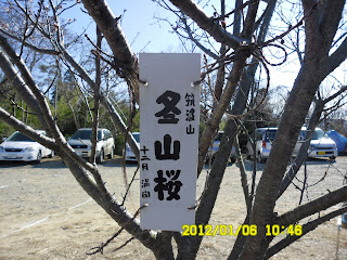
There were two trees both sides of the shop. There were “kan-zakura” or winter cherry and to my surprise, the cherry blossoms were in full bloom!
[Gama Park and Winter Cherry-tree, がま公園と冬桜、두꺼비 공원과 겨울 벚나무]
Tsukuba Shrine is one of the oldest shrines in Japan. It was my first visit to the shrine, so I enjoyed sightseeing at this shrine.
[Tsukubasan Shrine and Shin-kyo, 筑波山神社の神橋、즈쿠바산 신사의 신교]
After seeing here and there, I began climbing Mt. Tsukuba at 11:23 when I arrived at the bifurcation point of Cable Car Statin and the trail.
[Yamato Takeruno Mikoto, 倭建命(ヤマトタケルノミコト)、야마토 타케루노 미코토]
[The bifurcation point, ケーブル駅と登山路の分岐点、케이블역과 등산로의 분기점]
The trail was nice and not too steep. There were many big trees of “sugi” or “Japanese cedars” then “buna” or “beech trees.”
[The trail near "Miyukigahara", 御幸が原付近の登山路、미유키가하라부근의 등산로]
I arrived at Miyukigahara where the cable-car stain is at 12:56.
[A view from the top of Nantaisan, 男体山からの眺め、난타이산 정상에서의 조망]
From Miyukigahara to the top of Mt. Nantaisan (literly “Man’s Body Mountain: one of two peaks of Mt. Tsukuba), it is only 10 minute walk.
I had lunch at a small bench between Nantaisan and Miyukigahara.
[At Miyukigahara, 美幸が原にて、미유키가하라에서]
Then I headed for Nyotaisan (literly “Woman-body Mountain”.) Nyotaisan is a bit higher than Nantaisan and there were small shrines on both peaks.
[Toad Rock, 蝦蟇石、두꺼비 바위]
It was a fine day and I could enjoy nice views of Kanto Plain. I could see “Kasumigaura” lake, but could not see Mt. Fuji because of foggy holizone.
[At the top of Nyotaisan, 女体山山頂にて、뇨타이산 정상에서]
I began decending from Nyotaisan alone the trail leading to Tsutsujigaoka Bus Stop.
[The rope-way, ロープウェー、로프웨이]
On the way down, I happened to talk with an old gentleman and his grandson named “Ken-chan.”
[At Hokutoiwa, 北斗岩にて、북두바위에서]
After talked both guys, I found out that the gentleman is 9-year senior to me and “Ken-chan” is 7 years old.
The gentleman originally comes from “Tsuruoka” Hokkaido, but he went to Brasil just after World War Ⅱ.
He was not successful in Brazil so he came back to Japan in 1964. He spent 5 years there.
How interesting! I treated him a sip of Japanese sake called “Ohyama” which my brother-in-law in Tsuruoka gave me when I visited him earlier this year.
I arrived at Tsutsujigaoka Bus Stop at around 4 p.m. and went back to Tsukuba Station before 5.
[Tsutsujigaoka Rope-Way Station, つつじヶ丘ロープウェー駅、쓰쓰지가오카 로프웨이역]
It cost 850 yen from Tsutsujigaoka to Tsukuba. I came back to Ofuna at around 7 p.m.
This was my 2nd hike for the year 2012.
------------------------------------------------------------
登山月日: 2012年1月6日(金)、晴れ。
登山地:茨城県筑波山(877m)
登山コース:筑波山口~ガマ公園~筑波神社~男女川水源地~美幸が原~男体山~女体山~大仏石~弁慶の七戻り岩~つつじヶ丘バス停(約7km、6時間)
同行者:なし
山女子のブログを参考に、日本百名山の1つの筑波山へ向かう。
大船7時6分発の東海道線はものすごい込み様。大型リュックは両足の間に挟んで守ったが、新橋で降りたら、脇のポケットに入れておいたお茶がなくなっていた。
新橋から山手線で秋葉原へ。秋葉原からTXに乗り換えてつくばへ向かった。
[Mt. Tsukuba from Tsukubasan-guchi, 筑波山口から見た筑波山、쓰쿠바산-구치에게서 본 쓰쿠바산]
乗り換えは順調でつくば駅には9時15分に到着。3A出口を出たところがバスターミナルで、2番乗り場から「筑波山口」行のシャトルバスがすぐに出発したため、これに乗った。ケーブル駅のある筑波神社までバスで行くなら1番乗り場で10時まで待たねばならなかったので、これで正解。筑波山口までは約40分で料金は400円。これは安いと感じた。
筑波山口から筑波神社までは車道を歩かねばならなかったが、徐々に視界が広がり、快適な3.2kmだった。
[Gama Park Entrance, がま公園入口、두꺼비 공원입구]
神社手前の「がま公園」は無料駐車場になっていて、道路脇でなぜか宮崎産のきんかんが1袋500円で売っており、おばさんが買わなくていいから食べて行けと言って5,6個くれた。
[Winter-Cherry and tangerine peddler, 冬桜とみかん売りのオバさん、겨울 벚나무와 귤 판매 아주머니 ]
キンカンは好物なので1袋買ったら、ミカンを数個と蝦蟇の油の「いんろう」を2個くれた。この売店の両脇には「冬桜」の木があり、なんと「寒桜」が満開だった。
筑波神社は初めてなので少し時間を掛けて見学した。筑波神社は筑波山の「男体山」「女体山」を神体とする紀元前からの神社だと言う。山岳信仰は日本ではごく普通にみられるもので、その中でも「しにせ」の1つだろう。
[Toyokiirihiko-no-Mikoto、豊木入日子命(トヨキイリヒコノミコト)、도요키이리히코노 미코토]
神社の境内を左側に進むと、ケーブル駅と、「男体山」登山道がある。この分岐点に着いたのは11:23だから、バスを降りてからこのまで約1時間30分歩いた。
ケーブルカーは大山や箱根のものとそっくりで、男体山のすぐ下の御幸が原まで簡単に行ける。
[The trail and the Cable Car, 登山路とケーブルカー등산로와 케이블카]
登山道は杉の巨木が多く、大山の女坂のような感覚だ。平日だがハイカーは多い。
年配者が多く、時々山ガールの姿も見える。ケーブル終点の御幸が原には12:56に到着したから、ほぼ標準通りの90分かかった。
御幸が原から男体山山頂までは行ってこいのシャトル登山で、片道約10分。山頂の神社には人が一人いて、札などを販売していた。
[Nantaisan Shrine, 男体山神社、난타이산 신사]
山頂からの見晴らしは良く、霞ヶ浦がよく見えた。しかし、遠方はかすんで富士山などは見えなかった。
山頂からすこし下ったベンチで昼食。保温器に入れた日本酒も少々いただいた。
その後、御幸が原まで戻って、尾根伝いに女体山へ向かった。この尾根付近はブナの大木が多い。
[At the top of Nyotaisan, 女体山山頂にて、뇨타이산 정상에서]
女体山には14:26に到着。こちらの方が若干標高が高く、見晴らしもよかったが、やはり富士山は見えなかった。
女体山の神社にも人が一人、お守り札などを売っていた。人件費分を売り上げるのはたいへんだろうなと思った。
さて、下りはブログ同様、女体山~つつじケ丘のロープウェーの下のコースを歩いた。
山頂からバス停まで1.8kmとあり、巨岩、奇岩が楽しめる。
すこし下りはじめたところで上りと下りのロープウェーが交差する地点でロープウェーの写真を撮った。
するとおじいさんと孫らしき二人連れが私と同様にロープウェーのワンショットを狙っていたのに出会った。
なんとはなく会話が始まって、男の子は「ケンちゃん」で7歳。おじいさんは私より9つ上の大先輩。
[With "Ken-chan, ケンちゃんと、켄찬과 함께]
オーストラリアの孫の話をするとこのおじいさんも「わしも南半球に住んでいたことがある」という。話を聞くと終戦直後に成人し、一旗揚げようと北海道の鶴岡からブラジルへ渡り、5年間ブラジルに住んだがブラジルでの事業がうまく行かず、そのうち日本が高度成長期に入って景気がよくなったので、1964年の東京オリンピックの年に帰国したと言う。
[The grandpa and the grandson in front of Rimen-Daikokku Rock, 裏面大黒の前のおじいさんと孫、「이면 대흑 바위」앞의 할아버지와 손자]
グーグルで「北海道」「鶴岡」で検索すると道南の上磯郡木古内町字鶴岡というところに「渡島鶴岡(おしまつるおか)駅」というのがあるのでどうもここらしい。
下りの途中で休憩し、ケンちゃんには持参したチョコレートはケーキを、この大先輩とは私の妻の故郷の鶴岡の銘酒「大山」の熱燗をいっしょに飲んだ。
下りのペースはこの二人に合わせ遅めにして、つつじケ丘バス停には4時少し前に到着。すでにバス停に停まっていた筑波センター行きのバスに乗って帰路についた。
[A huge statue of toad, 巨大な蝦蟇の像、거대한 두꺼비 상]
br />
ちなみにつつじケ丘からつくば駅までのバス料金は850円だった。
この筑波山のハイキングは2012年の第2回目の登山である。
I like hiking very much. I used to go hiking with a Korean hiking club named “AhToSan.” This blog introduces mostly my hiking activities in Korea and Japan, and Sydney in Australia. As of January 2020, I live in Sydney suburb. I go Blue Mountains and bush walk in Sydney area. 私は2003年から2014年まで韓国の大田(テジョン)に住んだ日本人である。11年間、週末は主に「アトサン山岳会」に参加した。14年4月に帰国したが、2020年以降はおもにシドニーで暮らし、時折、日本へ帰国する程度である。したがって最近の記事はSR(Sydney Report)としてブルーマウンテンのトレッキングを中心に書いている。
About pictures/当ブログ内の写真について/당 블로그내의 사진에 대해서
Most of the pictures in this blog are taken by my camera, yet some of them were downloaded from the website of the hiking club. If you click any pictures, they become the original size.
当ブログ内の写真の大部分は筆者のカメラで撮影したものですが、一部、山岳会の共有写真からダウンロードしたものを含みます。すべて、各写真をクリックすれば、元のサイズに拡大します。
당 블로그내 사진의 대부분은 필자의 카메라로 촬영한 것입니다만 일부 산악회 공유 사진으로부터 다운한 것도 포함합니다. 모두 각 사진을 클릭하면, 원래 사이즈에 확대합니다.
当ブログ内の写真の大部分は筆者のカメラで撮影したものですが、一部、山岳会の共有写真からダウンロードしたものを含みます。すべて、各写真をクリックすれば、元のサイズに拡大します。
당 블로그내 사진의 대부분은 필자의 카메라로 촬영한 것입니다만 일부 산악회 공유 사진으로부터 다운한 것도 포함합니다. 모두 각 사진을 클릭하면, 원래 사이즈에 확대합니다.


0 件のコメント:
コメントを投稿