Hiking Date: May 4, 2013 (Fine)
Destination (mountain): JeAmSan, SaJaSan, IlLimSan, in Jangheung and Boseong, JeonNam Province
Hiking course: JeAmSan Forest Lodge(제암산휴양림) – JeAmSan – Gomjae(곰재) – Altar of Azalea(철쭉제단) - SaJaSan(사자산) – IlImSan (일림산) - Hweryong Tea Field(회령다원) – AhToSan Bus.
Partner: 25 AhToSan members including Jangsu and his mother
Jangsu joined AhToSan again, and this time with his mother. His mother owns a beautiy shop, and she looks young!
Since hiking places were far from Daejeon (JeonNam Province), we left one hour earlier than regular time.
Participants were only 26, but we enjoyed every minute of the hike thanks to the good weather and beautiful nature.
We arrived at the foot of the mountain (JeAmSan Forest Lodge) at 10:05. I took the group picture at 10:15, but Jangsu and his mother were using toilet at that time, so they were not in the picture.
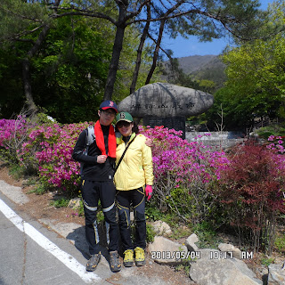
I took their picture at the guidepost at the entrance of the trail. Then his mother went ahead rather fast, not waiting for us.
From the entrance to the ridge, the trail was wide and gentle slope. There was a two-story observation building on the ridge.
The trail became narrow from from this building. When I passed the 1.3 km guidepost, a group of AhToSan members were waiting for me. We had “Suzuki Time”together.
I brought grapes and kumquats, and some brought “makgeolli”for the short rest. I got a sip of “makgeolli” too.
When we resumed hiking, we saw beautiful “royal azalea” so we took some pictures with these flowers.
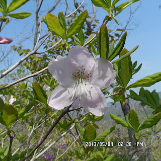
The main attraction of this hike was this “royal azalea”but besides this flower, I saw many “Iris rossii Baker.”
This flower is designated as “protected plant”by the government in 1935 in Japan, and “endangered species”by several local government in Japan. But here in Korea, we can see them often.
Besides these flowers, I could enjoy seeing violets in different colors, such as yellow, white and purple.
Jangsu and I caught up with his mother (or his mother was waiting for us) at the top of JeAmSan.
There were two stone monuments of JeAmSan. One is on the top of the cliff, and the other one was on the top of the hill.
Many brave AhToSan hikers climbed up the steep cliff to the first stone monument. I just saw them climbing up and down, but I did not try it. It seems too dangerous for me.
So, Jangsu and I took pictures with the monument on the hill. It was safer.
From JeAmSan to SaJaSan, the trail was on the gentle ridge. We could enjoy easy hike and nice views of mountains and flowers.
Jangsu’s mother picked up a violet flower and made a flower ring and wore it in her finger. I wonder how she did it.
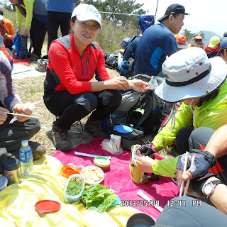
On the way to SaJaSan, we came to a heliport, and we decided to have lunch there.
I made several rice ball with “umeboshi” or “pickled plum”in Japanese style. Many AhToSan members brought wild vegitables such as leaves of “Aralia elata” [Taranoki(タラノキ) in Japan, and dureup namu (두릅나무) in Korea], etc.
After having 30 minute lunch time, we resumed our hiking. “SaJa” means lion in Korean language, and “SaJaSan” is Lion Mountain. It did look like a lion from the trail.
After passing SaJaSan, the trail was not steep, yet it was up and down along the ridge. We could see “royal azalea” here and there, but I had a little difficulties to climb the slopes. I felt pain in my shins.
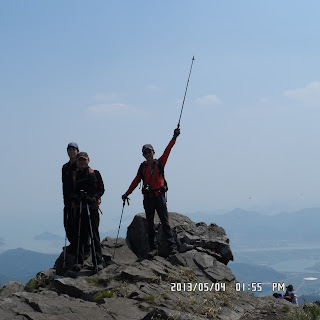
When we arrived at the top of the last mountain, IlImSan, it was 10 minutes past 4 o’clock. The views from IlImSan were beautiful. I could see “Iris rossii Baker” in the down trail as well.
It was already 7 hours past since we began hiking. Yet we could enjoy seeing azalea flowers in the last part of the hike.
We came down to the Hweryong Tea Field at 5:34. I clearly remembered that I came here several years ago. The scenery is very unique and you can never forget.
There are hinoki cypresses along the road. “Hinoki” is rare in Korea, it was also unique and unforgettable scene.
There were about dozens of workers picking up new tea leaves. That reminded me of “Chatsumi Uta” in Japanese version.
It goes “Summer is close since it is the 88th day after “risshun” or “the first day of spring.” The 88th day since “risshun” is May 2nd this year and it was May 4th that day. So they were picking tea leaves correct time, I thought.
I arrived at AhToSan bus at 5:53 with Jangsu and his mother and some other AhToSan hikers. Most of other hikers were already having wrap-up party, so we joined them.
The party ended at 6:20 and we came back to Daejeon at 9:20.
It was my 19th hike for this year and my 312th AhToSan regular hike as total participation.
--------------------------------------------------------------------------------------------------------------------------
分類:登山、韓国、春山
登山月日:2013年5月4日(土)晴れ
登山地:全南、長興(장흥)郡と宝城(보성)郡にまたがる湖南正脈(호남정맥)]上の帝岩山(제암산)- 獅子山(사자산)- 日林山(일림산)縦走
登山コース:帝岩山休養林(제암산휴양림) - 帝岩山山頂 – コムジェ(곰재) - ツツジ祭壇(철쭉제단) - 獅子山(사자산) - 日林山(일림산)頂上 – 会寧茶園(회령다원) – アトサンバス(16km, 7時間)
同行者:アトサン会員など25人(大徳大学学生・朴壮洙とその母親を含む)
今回も登山地が遠方のため、出発は南門6時で、自転車で到着。
壮洙が美容院を経営している母親を連れてきた。はて、どうやって申し込んだのだろう。ひょっとして飛び入り参加か。
二人はいっしょに座り、同じ音楽をイヤホーンでシェア。ただし、壮洙は車酔いで大変だったようだ。
山行出発地点の帝岩山休養林駐車場には10時5分過ぎに到着。集合写真は10:15に撮影したが、壮洙母子などトイレに行っていて抜けたものも多い。
里程標の手前で壮洙母子の写真を撮って、次に壮洙が私の写真を撮っている間に母親はどんどん先に進み、1時間半後に帝岩山山頂の下の絶壁の前で会うまで彼女は先頭グループとともに歩いたようだ。
登山路入り口から尾根道までは緩やかな広い登山路で、尾根に出たところにコンクリート製の立派な展望台があった。
この展望台から先は細い登山路で、1.3km地点の里程標を過ぎたあたりに会長らが私を待っていてくれて「スズキタイム」にした。今回はブドウとキンカンで、私もマッコリをごちそうになった。
小休止後に立派なサンチョルチュク(クロフネツツジ)の前で記念撮影をして先に進んだ。
約2.2km進んだ帝岩山の絶壁前には11:37に到着。
途中、サンチョルチュクのほか、エヒメアヤメがあちこちに見えた。今回のハイキングほど終始エヒメアヤメが見えた山行はない。
ネット情報によれば、日本では1935年に国の天然記念物に指定され、岡山県など、地方自治体からも絶滅危惧種に指定されている。そのように貴重な花がふんだんに見ることができるのはうれしい。
今回の山行では灌木の花であるツツジとサンチョルチュク(和名:クロフネツツジ)の他、足元に咲くエヒメアヤメや白や黄色や紫色のスミレも堪能した。
壮洙の母上とは、帝岩山の絶壁の前で会ってからは最後まで同行した。
帝岩山から獅子山へ向かう尾根歩きは広い草原で、気持ち良いハイキングだ。この尾根歩きでもエヒメアヤメをよくみかけた。
壮洙の母上はスミレの花を1つ摘んで器用に指の周りに着け、この花は「パンジッコ(반지꽃:指輪花)」と言うと教えてくれた。
後で彼女がしたように指輪にしようとしても簡単にできない。また会うことがあれば作り方を教えてもらおうと思う。
さて、広い草原を獅子山に向かって進み比較的広い場所が確保できるヘリポートで昼食にした。時間は12:45で、朝食が早かったせいもあり腹が空いた。
自分で作った梅干のおにぎり4個をすべて一人で食べた。おかずは同席したメンバーの、タラノメや卵焼きをごちそうになった。
30分ほどの昼食休憩の後、平原の山行を続け、獅子山の石標に着いたのは13:50だった。この地点からみる山の形はライオンの頭のようで、誰もが納得するネーミングだと思う。
獅子山を過ぎた尾根は緩やかな登山路で、チンダルレのような淡いピンクのツツジが密生している。山の高低はさほど厳しいものではないが、それでも上り坂は苦手だ。
日林山に至る手前の上り坂では足の脛が痛んだ。足の筋肉が攣るわけではないが、それでもかなりきつい気がした。
今回のコースは16kmで所要予定時間は7時間だったが、私は45分、余分にかかった。
つねに後尾グループとともに歩き、ゆるやかな丘のような日林山山頂には4時10分に到着した。
ここからさらにツツジが咲き乱れる尾根伝いに進み、宝城茶園に出る。尾根道の一部はツツジがまだつぼみの状態でこれがすべて咲きそろうとさぞかし見ごたえがあるだろうなと思われた。
見覚えのある茶園では20人ほどの人々がちょうど茶摘みをしていた。この茶園の入り口は一部檜の並木になっていて、印象深い。
茶園を過ぎて道路脇に止まっているアトサンの車に着いたのは5時53分。すでに大部分のハイカーは打ち上げパーティの真っ最中で、最後尾の我々も合流し、打ち上げを終えたのは6時20分だった。
帰りは当然遅くなり、大田ICには9時20分だから3時間で戻ったことになる。ワンルームに戻ったのは10時近かったがゆったりとした楽しいハイキングであった。
今年に入って19回目の登山であり、アトサン定期登山の参加回数は312回目。
I like hiking very much. I used to go hiking with a Korean hiking club named “AhToSan.” This blog introduces mostly my hiking activities in Korea and Japan, and Sydney in Australia. As of January 2020, I live in Sydney suburb. I go Blue Mountains and bush walk in Sydney area. 私は2003年から2014年まで韓国の大田(テジョン)に住んだ日本人である。11年間、週末は主に「アトサン山岳会」に参加した。14年4月に帰国したが、2020年以降はおもにシドニーで暮らし、時折、日本へ帰国する程度である。したがって最近の記事はSR(Sydney Report)としてブルーマウンテンのトレッキングを中心に書いている。
About pictures/当ブログ内の写真について/당 블로그내의 사진에 대해서
Most of the pictures in this blog are taken by my camera, yet some of them were downloaded from the website of the hiking club. If you click any pictures, they become the original size.
当ブログ内の写真の大部分は筆者のカメラで撮影したものですが、一部、山岳会の共有写真からダウンロードしたものを含みます。すべて、各写真をクリックすれば、元のサイズに拡大します。
당 블로그내 사진의 대부분은 필자의 카메라로 촬영한 것입니다만 일부 산악회 공유 사진으로부터 다운한 것도 포함합니다. 모두 각 사진을 클릭하면, 원래 사이즈에 확대합니다.
当ブログ内の写真の大部分は筆者のカメラで撮影したものですが、一部、山岳会の共有写真からダウンロードしたものを含みます。すべて、各写真をクリックすれば、元のサイズに拡大します。
당 블로그내 사진의 대부분은 필자의 카메라로 촬영한 것입니다만 일부 산악회 공유 사진으로부터 다운한 것도 포함합니다. 모두 각 사진을 클릭하면, 원래 사이즈에 확대합니다.
登録:
コメントの投稿 (Atom)


.jpg)


0 件のコメント:
コメントを投稿