Destination (mountain): GyeRyong San (Sambulbong and Gwaneumbong)
Hiking course: Bus-stop – Seol Restaurant – Mungol – Keusbaejae – Nammaetap – Sambulbong – Jayonseongseong – Gwaneumbong – Eumseon Waterfall – Donghaksa Temple – Bus-stop (10 km, 7 hours)
Partner: None
I had classes on Monday and Friday for the first semester. So, I can go hiking during the weekdays. It was a fine day and I went to Gyeryongsan again this day.

[A map of GyeRyongSan, 鶏龍山の地図、계룡산 지도]

[Arriving at the Donghaksa bus stop before 8:30, 東鶴寺バス停へ到着、동학사 버스 정류장에 도착]

[Main street to Donghaksa, 東鶴寺への道、동학사에 가는 도로]
I saw many “Iris rossii Baker” on the previous hike, but I could never seen a yellow Iris rossii Baker. 2 years ago, when I climbed this mountain, I found a beautiful yellow Iris rossii Baker at Cheonjeonggol, so I expected to find the one again this time. But my expectation was in vain.
This trail up to Nammaetap is wide and gentle, so it is one of my favorite trails in Korea. I saw many petals of cherry blossoms on the trail, but no Iris rossii Baker. In stead, I saw a red squirrel along the trail.

[A red squirrel, エゾリス、청솔모]

On the way to Nammaetap, there is a spring in the middle of the course. Originally, I was thinking of taking water from this spring, but I saw a plate next to the spring, it said “No drinking.” Wow, I drank many times before!
While I climbed up and up, I saw some “Jindallae” here and there. When I arrived at Keunpaejae, there were several “Jindallae” trees, and they were in full bloom.

[A guidepost at Keunpaejae, クンペジェの標識、큰배재 이정표]

From this point to up to the first peak, Sambulbong, and all the way to Gwaneumbong, the trails were decollated with beautiful flowers of “Jindallae” and “Sancheolchuk” or “Royal azalea” or even cherry blossoms. So, I could enjoy seeing these flowers.

[The buds of royal azalea、クロフネツツジの蕾、산철쭉 꽃 봉오리]

[Nammaetap, 男妹塔、남매탑]

[SangWonAm, 上元庵、상원암]
Up to Nammaetap, the trail was nice and gentle, but from Nanmaetap to Sambulbong, the trails were rocky and last approach to the peak was a steep iron stairs.

[Gentiana thunbergii, ハルリンドウ(春竜胆) or コケリンドウ(苔竜胆)、구슬붕이]

[Yellow violets, 黄色いスミレの花、노란 제비꽃]

[Steel stairs to Sambulbong, 三仏峰の鉄階段、삼불봉 철계단]

[At the top of Sambulbong, 三仏峰にて、삼불봉에서]

[At the top of Sambulbong, 三仏峰にて、삼불봉에서]

[At the top of Sambulbong, 三仏峰にて、삼불봉에서]
When I asked their course, it was same as mine, but their pace was much faster, like AhToSan hikers, so I said good-bye to them after taking their pictures.
The 1.5 km ridge course from Sambulbong to Gwaneumbong is called “Jayon-Seongreung” but I do not now what Kanji they were. It could be “自然城陵,” but it is only my guess.

[A guidepost at the ridge, 『自然城陵』にて、"자연성릉"에서]

[Jindallae at the ridge, 『自然城陵』にて、"자연성릉"에서]

[Yellow violets at the ridge, 『自然城陵』にて、"자연성릉"에서]
At the end of this trai, there were steep iron stairs again. And when I looked back, I could see peaks of the mountains very well.

[A concrete gazebo on Gwaneungbong, 観音峰のコンクリートの東屋、관음봉 콘크리트 정자]

[Viewing the peaks of Sambulbong, 観音峰から三仏峰を眺める、관음봉에서 삼불봉을 바라본다]

[At GwanEumBong, 観音峰にて、관음봉에서]
I took some pictures at the peak of the mountain, then had lunch there and began descending the mountain.
I do not like this part of the course, because it was a steep rocky trail. I could not see many colorful flowers, but I did see blue flowers along the trail.

I arrived at Eunseong Waterfall at 1:43. This waterfall is rather famous and many sightseers come to see from the bus-stop.

[A little water in Eunseng Waterfall, 隠仙瀑布、음선폭포]

[Viewing Ssanlgaebong near the waterfall, サルゲ峰、살개봉]
For the first group, I said about 20 minutes, for the 2nd group, I answered it would be about 30 more minutes.
They were not hikers, but sightseers. I could tell by seeing their clothes and shoes.
The water at the waterfall was too little and not very dynamic at all. But the water in the valley was plenty, and I could hear the sounds of running water.
I arrived at Donghaksa Temple at 2:10. The temple was decorated with a lot of colorful lanterns because Buddha’s birthday was just around the corner (5/17).

[Donghaksa Temple, 東鶴寺、동학사]

[Bleeding hearts, タイツリソウ、금낭화(錦囊花)]

[“Kerria japonica”, ヤマブキの花、황매화黃梅花]
At the end of the trail, in front of "Seoul Restaurant" I saw a chipmunk. It is very cute.

[Chipmunk、シマリス、다람쥐]
It was my 20th hike for this year.
------------------------------------------------------------------------------------------------------------------------
分類:韓国、登山、春山
登山月日:2013年5月7日(火)晴れ
登山地:忠南、公州市
登山コース:東鶴寺バス停~ソウル食堂~門谷(문골)~門谷三叉路(문골삼거리)~[チョンジョンゴル(천정골)]~クンペジェ(큰배재)~男妹塔(남매탑)~三仏峰峠(삼불봉고개)~三仏峰(삼불봉)~自然ソンヌン(자연승능)~観音峰(관음봉)~隠仙瀑布(음선폭포)~東鶴寺(동학사)~ソウル食堂~東鶴寺バス停(約10km、約7時間)
同行者:なし
今学期は月曜日と金曜日に授業があるが、そのほかは授業はない。それで週中の鶏龍山登山に挑戦した。
.jpg)
[A map of GyeRyongSan, 鶏龍山の地図、계룡산 지도]

[A general store "K Mart", 雑貨屋「Kマート」、구멍 가게 "K 마트"]
今回もソウル食堂前の分岐で右折し、今回も入山料がかからない「チョンジョンゴル(천정골)」コースを選択。このコースは勾配が緩やかで道幅も広いため快適だ。

[[Royal azalea in Gyeryongsan、鶏龍山のクロフネツツジ、계룡산 산철쭉]]

[A red squirrel, エゾリス、청솔모]

遅咲きの桜が散って、その花びらが登山路に点々としている。門谷三叉路(문골삼거리)付近にある水場には赤い字で「飲用不適」と大書してあるのには驚いた。前回はこの注意書きはなく、今回も当初ここで水の補給をするつもりだった。
高度があがるにつれチンダルレが見えるようになった。クンペジェ直前の木の階段を上るとチンダルレが咲いていて、この地点から観音峰に至るコースはどこもチンダルレが満開ですばらしい。

[A guidepost at Keunpaejae, クンペジェの標識、큰배재 이정표]

[A coffee break at Geunpaejae, クンペジェでコーヒー休憩、큰배재에서 커피 휴식]

[Gentiana thunbergii, ハルリンドウ(春竜胆) or コケリンドウ(苔竜胆)、구슬붕이]
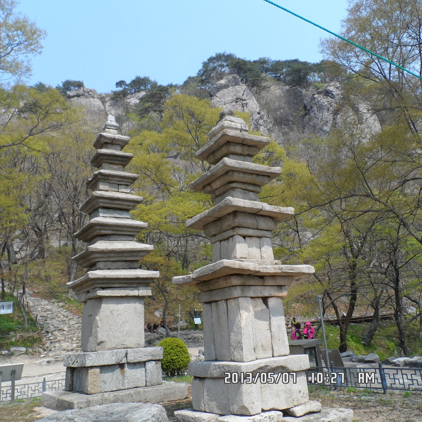
[Nammaetap, 男妹塔、남매탑]

[“One Thousand Year Medical Water" “SeokGanSu"、千年薬水・石間水、천년 약수 · 돌 사이 물]


[Yellow violets, 黄色いスミレの花、노란 제비꽃]

[Korean azalea near Sambulbong, 三仏峰のチンダルレ、삼 불 봉의 진달래]

[At the top of Sambulbong, 三仏峰にて、삼불봉에서]

[At the top of Sambulbong, 三仏峰にて、삼불봉에서]

[At the top of Sambulbong, 三仏峰にて、삼불봉에서]
三仏峰から観音峰までの1.5キロのコースは「チャヨンソンルン(자연성릉)」と呼ばれるが漢字はわからない。多分「自然城陵」ではないかと思う。自然の城あるいは陵のようだと言う意味か。

[Yellow violets at the ridge, 『自然城陵』にて、"자연성릉"에서]
ここはいつあるいても素晴らしい。前後の景観も、左右の景観も良いし、岩の上の松も風情がある。

[Korean azaleas on the ridge, 稜線のチンダルレ、능선의 진달래]
このコースでは観音峰への最後のアプローチが急勾配だが、しっかりした鉄製の階段と手すりがあるから安全だ。

[Viewing the peaks of Sambulbong, 観音峰から三仏峰を眺める、관음봉에서 삼불봉을 바라본다]

[At the top of Gwaneumbong, 観音峰の頂上にて、관음봉 정상에서]
昼食はキムパプとカップラーメンで30分ほど休んで1時に下山を開始した。
隠仙瀑布までは急こう配の石の階段で、一気に下る。周囲にチンダルレは皆無で、ときおりサンチョルチュクの白い花が見える。
隠仙瀑布は水量が乏しく、ちょろちょろだが、これを観るために登ってくる団体2グループに会った。どちらからもあとどのくらいかと聞かれ、最初のグループには20分、次のグループには30分と答えた。
この下りのコースの渓谷の水量は、チョンジョンゴルに比べ多い。水の音を聞きながらの快適な下りで、「香牙橋」をわたった東鶴寺には2時10分に到着。

[River in the valley near the temple, 東鶴寺近くの渓谷、동학사 근처 계곡]

[The garden of Donghaksa, 東鶴寺の庭、동학사 정원]
釈迦誕生日(今年は5月17日)の祝いのための飾りつけの最中で、色鮮やかなぼんぼりがびっしりと飾られていた。
庭にはさまざまな花が咲いているが、「タイツリソウ」が特に目を引く。また山吹の花も良い。ソウル食堂の前ではシマリスをみかけた。

[Chipmunk、シマリス、다람쥐]
3時のバスで儒城へ行き、704番バスで新城洞へ戻った。今年20回目の登山であった。
0 件のコメント:
コメントを投稿