Mount Myōkō is listed as one of 100 Famous Japanese Mountains, and together with Mount Yahiko (弥彦山 Yahiko-yama), it is well known as the "famous mountain" of Niigata Prefecture.

[Mt. Myoko from bird's eye (from Internet), 妙高山の航空写真、묘코산의 항공 사진]
Hiking Course: Seki-onsen (Mr. S’ car) -> Tsubame-onsen – Myosen Bridge – Asadaira Branch – Chinoike – Yumichi Branch – Munatsuki Hacho – Tengudo – Fu-ketsu (Wind Hole) – Kusariba (Chain Field) – The sumit of Mt. Myoko ----Yumichi Branchi – Ogon-no Yu (Golden Spa) – Tsubame-onsen (Mr. S’ car) -> JR Sekiyama ST
Public Transportation for return trip: JR Sekiyama – (Shinetsu Line) – Nagano – (Shinkansen) – Tokyo – (Tokaido Line) – Ofuna
Hiking Partner: Mr. S (my old classmate at NTT College in late 1970s who lives in Takaoka, Toyama Prefecture)
We got up at 4:30 and had breakfast in our hotel room. We checked out at 5:25 am.

[In front of "Senzan", 旅館『泉山』の前で、여관 "센잔"앞에서]

[Celosia argentea, commonly known as plumed cockscomb at Tsubame-onsen, 燕温泉のケイトウの花、츠바메 온천 맨드라미 꽃]

[Time Table for bus at Tsubame Onsen, 燕温泉のバスの時刻表、츠바메 온천 버스 시간표]

[A map of Mt. Myoko, 妙高山登山地図、묘코산 등산 지도]

[At the entrance of the trail, 妙高山登山口にて、묘코산 등산로 입구에서]

[At a temporary trail, 仮の階段にて、임시 계단에서]

[The bridge was under construction, つり橋は工事中だった、현수교는 공사중이었다]

[A view from the 1st ST, 一合目付近にて、1부 능선 부근에서]

[The trail covered with moss、苔に覆われた登山路、이끼 덮인 등산로]
http://en.wikipedia.org/wiki/Monotropastrum_humile

[Monotropastrum humile or "Indian pipes", ギンリュウソウ(銀竜草)またはユウレイダケ、"긴류우소우"(은룡초)]

I saw these plants at Oze a couple of years ago. This time, I saw many of them and I felt very happy.

[The trail around the 2nd ST, 二合目付近の登山路、2부 능선 부근의 등산로]
So, I walked ahead, then waited for him. When he caught me up, then he started smoking and I began walking ahead. We repeated this pattern all the way to the summit, and then coming down to Tsubame onsen.
I arrived at Asadaira Branch (2nd ST) at 6:22, then Chinoike(血の池) or“The Blood Pond” of altitude 1,500m at 7 am.

[The mark of the 2nd ST "The Blood Pond"、『血の池』の標識、"피의 연못" 표지]

[A view from the 3rd ST, 三合目付近にて、3부 능선 부근에서]

[The guide post of the 3rd ST, 三合目の標識、3부 능선 표지판]

[A wild flower around the 3rd ST. 三合目付近の野生花、3부 능선 부근의 야생화]

[Mushrooms around the 3rd ST. 三合目付近のキノコ、3부 능선 부근의 버섯류]

[Near the 4th ST, 四合目付近にて、4부 능선 부근에서]

[The stream at Yumichi, 湯道のそばの小川、"유미치" 옆 시내]

[At Yumichi Branch, 湯道分岐にて、유미치 분기에서]

[Wild flowers at the 4th ST, 四合目付近の野生花、4부 능선 부근의 야생화]

[A fruit of trillium, エンレイソウ(延齢草)の実、연령초의 열매]

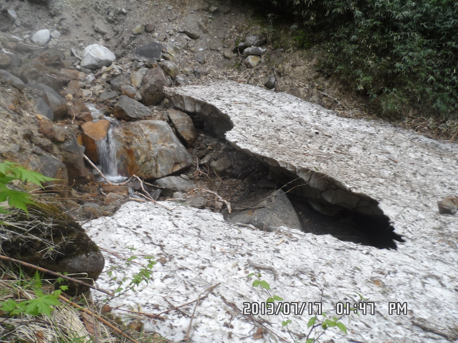
[Snowy gorge near the 5th ST,五合目付近の雪渓、5부 능선 부근의 눈 골짜기]

[At the 5th Station, 五合目にて、5부 능선에서]
There was a wood of white birches. When I went through the wood, then I came to “Tengudo” which was the 6th ST of the mountain (1,930m.)

[The guidepost of the 6th ST, 六合目の標識、6부 능선 표지판]

[Mountain hydrangea and tea of heaven、ヤマアジサイ、야마아지사이 (산 수국)]
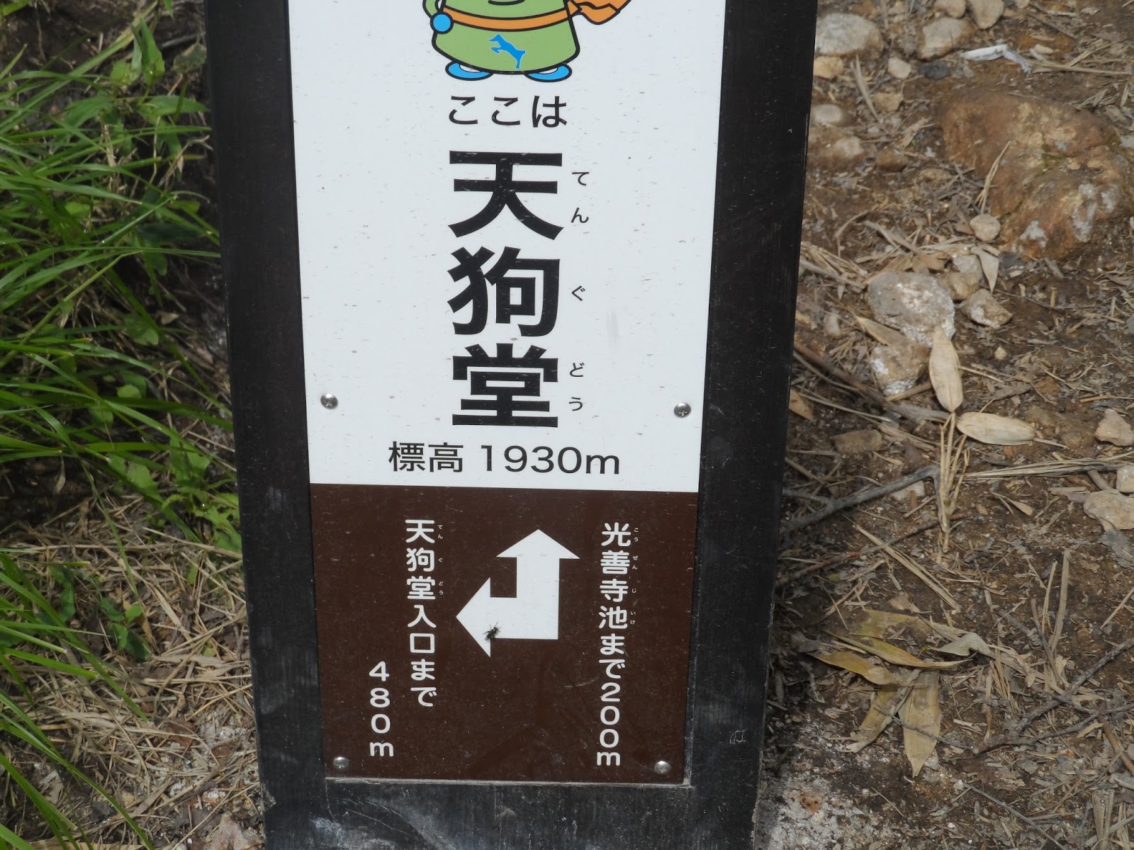
[The guidepost of Tengudo, 天狗堂の標識、텐구도의 표지판]

[The Tengudo, 天狗堂、텐구도]

[The guidepost of "Kozenji Pond", 光善寺池の標識、"코젠지 연못"의 표지판]

["Kozenji Pond", 光善寺池、"코젠지 연못"]

[Cornus canadensis or Canadian Dwarf Cornel,ゴゼンタチバナ(御前橘),고젠 타치바나고젠 타치바나 (고산 식물)]

[A wild flower at the 7th ST, 七合目付近の野生花、7부 능선 부근의 야생화]

There was two small wind holes at “Fu-ketsu” and cool wind came from these caves. I waited for Mr. S while having a rice-ball.

[Wind Hole 風穴、바람 구멍(풍혈)]

[At Wind Cave, 風穴にて、바람 구멍에서]

[Alpine flora around 8th ST, 八合目付近の高山植物、8부 능선 부근의 고산 식물]

[The mark of 9th ST, 九合目の標識、9부 능선의 표지판]

[At Chain Field of the 9th ST, 九合目の鎖場にて、9부 능선 사슬장에서]

It was cloudy that day, but when I came to the 9th ST, I could see other mountains, esp. Mount Hiuchi (火打山 Hiuchi-yama) in front of me.

[Mt. Hiuchi is behind the clouds, 雲の向こうは火打山、구름의 저편는 히우치야마]

When I climbed up to the top of the cliff at Chain Field, it was close to the summit, yet had to walk through rocky place for about 50 meters.
The rocks are consolidated lava, similar to Mt. Fuji. But I could see alpine flowers even on the consolidated lava rocks.

[Lingonberries or cowberries, コケモモ(苔桃)、월귤(越橘)]

[Alpine flora near the summit, 頂上付近の高山植物、정상 부근의 고산 식물]

[he Keyflower (Dactylorhiza aristata), ハクサンチドリ、"학산 치도리"(고산 식물)]

[Near the summit of Mt. Myoko, 妙高山頂上付近にて、묘코산 정상 부근에서]

[Alpine flora near the summit, 頂上付近の高山植物、정상 부근의 고산 식물]


[Near the summit of Mt. Myoko, 妙高山頂上付近にて、묘코산 정상 부근에서]

[The mark of Myokosan summit, 妙高山十合目の標識、묘코산 10부 능선 표지판]

[George at the top of Mt. Myoko (2,454m), 妙高山山頂にて、묘코산 정상에서]

["Shogun Jizo" or "Myoko Daimyojin" 将軍地蔵(妙高大明神)、장군 지장 보살 (묘코 대명신)]

[Mt. Hiuchi from Myoko summit, 妙高山頂上からみた火打山、묘코산 정상에서 본 히우티야마]

[At the summit of Myokosan, 妙高山頂上にて、묘코산 정상에서]

We saw a woman hiker coming up when we began descending. Her walking pace was much faster than us. When I was walkd down after “Yumichi Branch” she passed over me.

[Alpine flora near the summit, 頂上付近の高山植物、정상 부근의 고산 식물]

[Snowy gorge near the 5th ST, 五合目付近の雪渓、5부 능선 부근의 눈 골짜기]
Anyhow, I waited for Mr. S at Yumichi Branch, and decided to go down first and to wait for him at “Ogon-no-yu黄金の湯” or “Golden Spa” while enjoying the spa.

[At Yudo-Branch, 湯道分岐にて、"유도 분기"에서]

[On the way for descending, 下山路にて、하산 길에서]


[On the way for descending, 下山路にて、하산 길에서]

[The hut to control Akakura-onsen, 赤倉温泉源泉管理小屋、아카쿠라 온천 원천 관리 오두막]

[On the way for descending, 下山路にて、하산 길에서]

I arrived at “Ogon-no-yu黄金の湯” at 3:10 pm. It is a public open-air hot-spring, and to my surprise, free of charge.

{The entrance of "Golden Spa", 「黄金の湯」の入り口、"황금 탕"의 입구]

[Golden Spa for men, 黄金の湯の男湯、황금탕의 남탕]

[Changing Room of Golden Spa, 男湯の着替え室、남탕의 탈의실]

[Cast‐off skin of a snake, ヘビの抜け殻、뱀의 허물]
Mt. S arrived at the spa at 3:30 pm. We still had enough time for him to enjoy the spa.
We left the spa at 3:45 and hurried to JR Sekiyama Station. Mr. S sent me off at the station and I took a train at 4:20 pm.
Just before the train arrived, it began raining. I am very much thankful to my God that He allowed us to climb Mt. Myoko safely, without rain.
On the way back, I took “Nagano Shinkansen” which brought me to Tokyo very fast.
It was raining in Kanto area, but I could come back to Ofuna without getting wet at all.
----------------------------------------------------------------------------------------------------
分類:登山、日本、東北・上信越, 日本百名山(Best 100 Mountains in Japan)

[Mt. Myoko in winter (from Internet)、冬の妙高山(ネットより)、겨울 묘 코산 (인터넷에서)]
登山目的地:上信越高原国立公園の妙高山(2,454m)
登山コース:関温泉「泉山」→燕温泉登山口~妙仙橋~麻平分岐(二合目)~血の池(三合目)~湯道分岐~胸突き八丁(五合目)~天狗堂(六合目)~風穴(八合目)~鎖場(九合目)~妙高山山頂~湯道分岐~黄金の湯(無料露天風呂)~燕温泉登山口
復路の交通機関:JR関山駅→ (信越本線) → 長野 →(新幹線)→ 東京 → (東海道線) → 大船
パートナー:前夜宿泊した「泉仙」から帰路のJR関山駅までS氏、関山から大船までの帰路は単独旅行。
朝4時半に起床。5時に前日コンビニなどで購入した朝食を食べ、5時25分には旅館を出た。

[In front of "Senzan", 旅館『泉山』の前で、여관 "센잔"앞에서]

[Hydrangea、アジサイ(紫陽花)、수국]

[Time Table for bus at Tsubame Onsen, 燕温泉のバスの時刻表、츠바메 온천 버스 시간표]

[Traditional Japanese inns at Tsubame Onsen, 燕温泉の旅館街、츠바메 온천 여관 거리]

[At the entrance of the trail, 妙高山登山口にて、묘코산 등산로 입구에서]

[At a temporary trail, 仮の階段にて、임시 계단에서]

[At the 2nd ST, 二合目にて、2부 능선 에서]

[A lot of ferns, シダ類の植物、양치류 식물]
開けた場所に出ると遠くの町や山々が見える。足元の植物で最初に目についたのは尾瀬で見た「ギンリュウソウ(銀竜草)別名『ユウレイタケ』」だ。
尾瀬では二、三カ所しか見なかった「ギンリュウソウ」だが、今回は大小さまざまなサイズで実によく目にした。
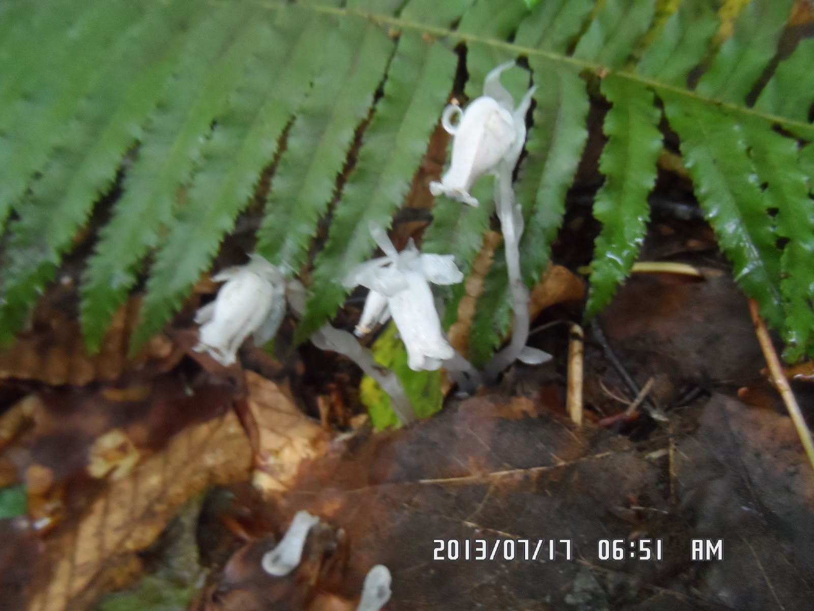
[Monotropastrum humile or "Indian pipes", ギンリュウソウ(銀竜草)またはユウレイダケ、"긴류우소우"(은룡초)]


[At the 2nd ST, 二合目付近にて、2부 능선 부근에서]
二合目の「麻平分岐」には6:22に到着。標高1,500mの三合目の「血の池」には7時に到着した。
「血の池」の由来はおそらく温泉の成分の影響で岩が赤いためだろう。

[Mt. Myoko around the 3rd ST, 三合目付近から見た妙高山、3부 능선 부근에서 본 묘코산]

[A view from the 3rd ST, 三合目付近にて、3부 능선 부근에서]

[A wild flower around the 3rd ST. 三合目付近の野生花、3부 능선 부근의 야생화]

[Near the 4th ST, 四合目付近にて、4부 능선 부근에서]

[At Yumichi Branch, 湯道分岐にて、유미치 분기에서]

[Wild flowers at the 4th ST, 四合目付近の野生花、4부 능선 부근의 야생화]

[A fruit of trillium, エンレイソウ(延齢草)の実、연령초의 열매]

[At the 5th Station, 五合目にて、5부 능선에서]

[Near the 6th ST, 六合目付近にて、6부 능선 부근에서]

[At the 6th ST, 六合目にて、6부 능선에서]

[Mountain hydrangea and tea of heaven、ヤマアジサイ、야마아지사이 (산 수국)]
天狗堂の前はかなりひらけていて、S氏を待つ間に持参したフルーツを切った。

[Parnassia palustris or Bog-star? ウメバチソウ? 우메바찌소우?]

[Cornus canadensis or Canadian Dwarf Cornel,ゴゼンタチバナ(御前橘),고젠 타치바나고젠 타치바나 (고산 식물)]

["Kozenji Pond", 光善寺池、"코젠지 연못"]

[The mark of the 7th ST, 七合目の標識、7부 능선의 표지판]

[A wild flower at the 7th ST, 七合目付近の野生花、7부 능선 부근의 야생화]

[Indian pipes around the 7th ST, 七合目付近のギンリュウソウ、7부 능선 부근의 "긴류우소우"]

[At Wind Hole, 風穴にて、바람 구멍(풍혈)에서]

[Alpine flora around 8th ST, 八合目付近の高山植物、8부 능선 부근의 고산 식물]

[The mark of 9th ST, 九合目の標識、9부 능선의 표지판]
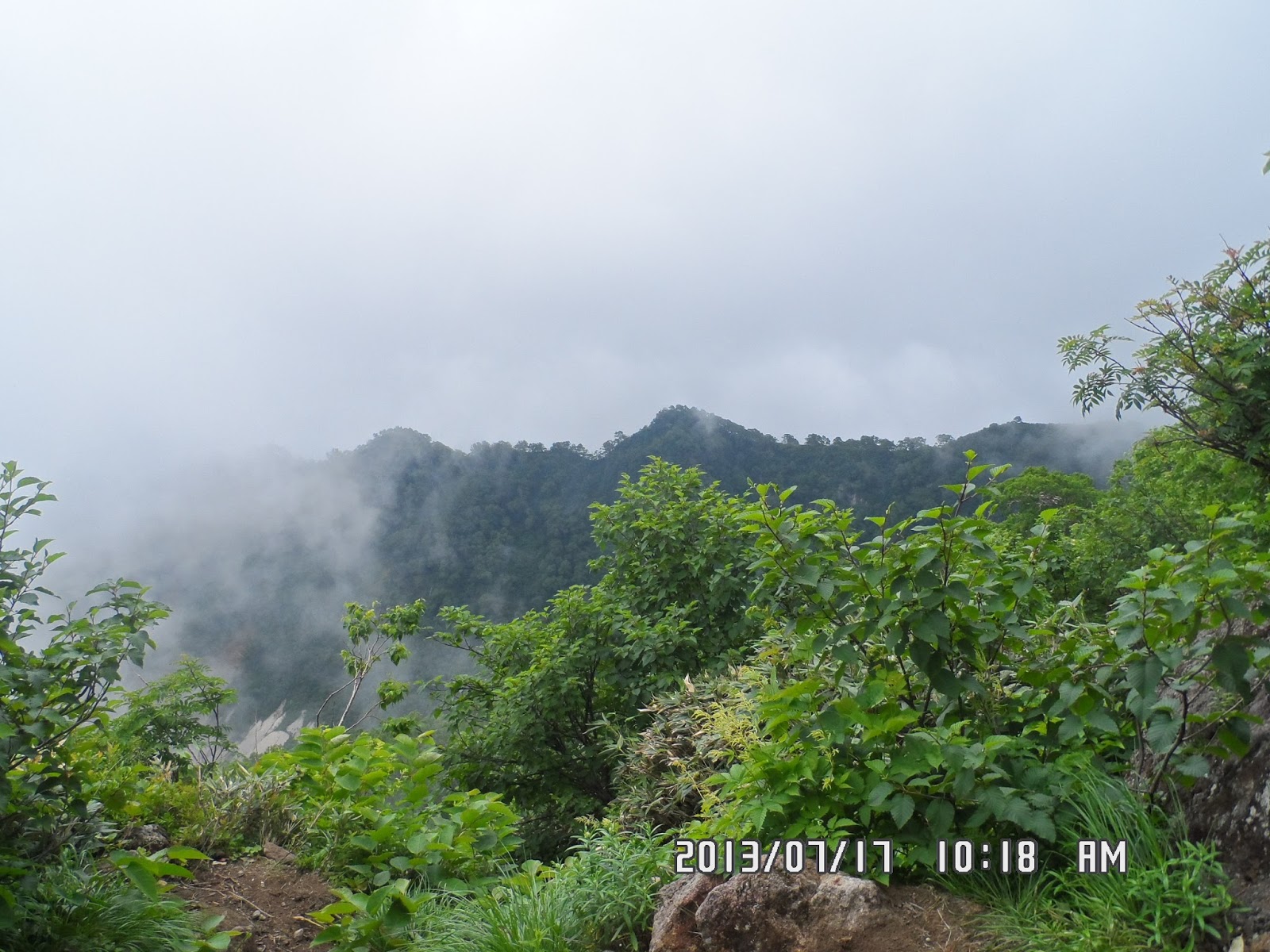
[Viewing nearby mountains at the 9th ST, 九合目にて峰々を望む、9부 능선에서 산봉우리를 보았다.]

[At Chain Field of the 9th ST, 九合目の鎖場にて、9부 능선 사슬장에서]

鎖場を登り始めたのは10:42。ベルナルドや松本さんと登った四国の石鎚山の頂上付近を思い出した。
だが、妙高は石鎚と違って登り切ってからさらに岩場を登らなければならない。
この頃、雲がやや切れて展望が開けた。また岩場に咲く小さな高山植物がかわいいし、きれいだった。

[Lingonberries or cowberries, コケモモ(苔桃)、월귤(越橘)]

[Mt. Hiuchi is behind the clouds, 雲の向こうは火打山、구름의 저편는 히우치야마]

[Alpine flora near the summit, 頂上付近の高山植物、정상 부근의 고산 식물]

[Near the summit of Mt. Myoko, 妙高山頂上付近にて、묘코산 정상 부근에서]

標高2454mの十合目の標識に着いたのは11:15。足元の丸い銅製の標識には「妙高大明神」とあり、「ここは標高2,454m」とあった。また、この胸式では、東西南北の方向が記されていた。

[The copper mark of the summit, 銅製の妙高山山頂の標識、동제의 묘코산 정상 표지판]

[Mr. S on the summit, 妙高頂上のS氏、S씨가 묘코산 정상에 앉아있다.]

[Mr. M in front of the "Myoko-Daimyojin", 妙高大明神の前のS氏、"묘코 대명신"앞의 S 씨]

[At the summit of Myokosan, 妙高山頂上にて、묘코산 정상에서]


[he Keyflower (Dactylorhiza aristata), ハクサンチドリ、"학산 치도리"(고산 식물)]
頂上から鎖場へ下る途中、地元関山の女性ハイカーと会った。S氏はこの女性ハイカーとかなり長く話をしたそうで、彼の社交性に感心した。
この女性は我々よりかなり早いスピードで登山していて、頂上到達後、すぐに下山を開始し、S氏を追い越して、私は燕温泉の源泉付近で追い抜かれた。
私は往路で左足が攣り、やや痛む足で登頂したが、下山の鎖場への岩場では両足が攣った。
五合目の胸先八丁の下は雪渓で、この上を歩く時はアイゼンもないので注意を要した。

[Snowy gorge near the 5th ST, 五合目付近の雪渓、5부 능선 부근의 눈 골짜기]
S氏は私よりさらに遅れ気味で、「湯道分岐」で彼を待った後、往路とは別の登山路を下り、「黄金の湯」で彼を待つことにした。

[At the 4th ST on the descending trail, 下山路の四合目、하산로의 4부 능선]

[On the way for descending, 下山路にて、하산 길에서]


[Springhead of Akakura-onsen, 赤倉温泉の源泉、아카쿠라 온천의 원천]

[On the way for descending, 下山路にて、하산 길에서]

[The mark of Ogon-no-Yu(Golden Spa), 黄金の湯(公衆露天風呂)の標識、황금탕 (공중 노천탕) 표지판]

[Golden Spa for men, 黄金の湯の男湯、황금탕의 남탕]

[The hot-spring comes out from this, 湯の出口、뜨거운 물 출구]
再生と言えば、まるで死んだようになったさなぎが、時が来れば開いて中から美しい蝶が誕生するほうが、より神秘的な感じがする。このきれいなさなぎはどんなチョウになるのだろうか。

[A butterfly pupa, チョウのサナギ、나비의 번데.]
途中、昨日「笹寿司」を買った生協に寄り夕食用の「笹寿司」と土産用に「野沢菜」を買った。
S氏とは関山駅で午後4:20に再会を誓って別れ、午後4:28の信越線に乗った。
長野到着が大幅に遅れ新幹線の発車時刻ぎりぎりになった。長野駅から先は雨が本降りで関東地方も雨だった。
妙高登山中に雨にならなかったことを、そして無事に下山できたことを神に感謝した。
Its a very informative post, i read it a found new useful stuff that is very useful for me...
返信削除Bigrock Web Hosting Company Reviews
Fatcow Web Hosting Company Reviews
Bluehost Web Hosting Company Reviews
Thanks for visiting my blog.
返信削除