Destination (mountain): GaEunSan, Jecheon
Hiking course: Sangcheon SA – Mulgae Pawi (Otter Rock) – Mt. Gaeunsan – Dungjibong – Sae Pawi – Oksun Daekyo (5 hours, 10 km)
Partner: About 40 (including Cris and “Chinhan Saram” from Seoul)
 [A group picture at Sangcheon Ri, サンチョン里にて団体写真、상천리에서 단체사진]
My condition was very good. (blood sugar level was 97 mg/dl, blood pressure: 114-68) I could walk in the top group all the way.
It took about 3 hours from Daejeon to Gaeunsan, Jeceon (near Danyang.)
When we arrived at the foot of Mt. Gaeunsan, Cris and Chinhan Saram were there, waiting for us. While waiting for us, they seemed to have a couple of “makgeolli”at a local restaurant.
 [Cris preparing for the hike, 日焼け止めクリームを塗るクリス、썬크림을 바르는 크리스]
 We began to hike at 10 a.m. The first approach to the mountain was steep and rocky. Even though my condition was good, I had a hard time.
The altitude of this mountain was only 575m, it is between Tokyo Tower (333m) and Tokyo Sky Tree (634m), yet, it was really a difficult hike. I indeed realized the fact that the difficulty of the hike was nothing to do with the hight of the mountain. We had a good view when we came to the ridge.
 [On the rock on the way to the peak, 頂上への途上で、정상으로 가는 도중에서]
 We arrived at the peak of the mountain at around noon. I put my sheet to the one of Alain Delon’s.
 [At the top of the mountain, 加隠山頂上にて、가은산 정상에서]
Yoyu came with one of his colleages who was a young lady. She was quite charming, and she took her first mountain with AhToSan, “Gaeunsan” as her nickname. So we call her “Gaeun” from now on.
We had another young hiker who joined a couple of times before. His name is Byonggwon and he came to Stammtisch before. So he speaks English.
Since Cris speaks good Korean, AhToSan members do not need to speak in English, but if anyone speaks to him in English, he answers in English.
 [Cris and Chomwa, クリスとチョムワ、크리스와 첨와]
 [A group picture on the rock, 岩の上で団体写真、바위 위에서 단체사진]
As for the lunch table, another member whose nickname is “Ososan” joined us. We ate together, and started for the “after-lunch” hike together.
 [Lunch time, ランチタイム、점심식사]
The top group consisted of the young trio (Cris, Byongkwon and Gaeun), and Ososan and I followed them.
There were several steep slopes in the downhill trail, but we always walked in the woods, under the shadow of trees. It was quite comfortable.
We walked across the river, but too little water. Many members expected bathing, were disapointed, but we could not help it.
The downhill suddenly ended with the wooden stairs to the big bridge, “Oksun Bridge.” We could see Lake Chongju well from the stairs.
 [The hike ended at the lake, 下山路は忠州湖で終わった、하산로는 충주호에서 끝났다. ]
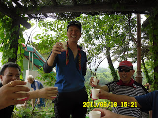
We had “wrap-up”party at the parking lot by Lake Chongju. The menu of the party were Dotorimuk (acorn-starch jelly paste) and makgeolli, typical menu for the summer.
 [A member making "Dotorimuk" salad, トトリムック・サラダを作るアトサン会員、도토리묵 샐러드를 만드는 아토산 회원]
 [The president calls for "cheers!" 乾杯の音頭をとる会長、건배를 외치는 회장님]
  ["Dotorimuk" or acorn-starch jelly paste dish, トトリムック・サラダ、도토리묵]
Cris and Chinhan Saram went back to Seoul from Chechon Bus Terminal, and we came back to Daejeon at 7 p.m.
This was my 36th hike for this year, and also my 244th hike as AhToSan regular hike.
---------------------------------------------------------------------------------------
登山月日:2011年6月18日(土) 曇り時々晴れ
登山地:忠北(충북)・堤川(제천)の加隱山(カウンサン가은산) 575m
登山コース:サンチョン休憩所(상천휴게소) – オットセイ岩(물개바위) - 加隠山 – ドゥンジボン(둥지봉) – セパウィ(새바위) - 玉筍大橋(옥순대교) (5時間/約10KM)
同行者:アトサン会員約40人(外国人はアメリカ人クリスと私だけ)
今回の体調はかなり良く、登山は終始先頭グループだった。登山地の堤川・加恩山(562m)は丹陽郡の近くで、ちょうど3時間かかった。
登山口にはソウルからバスとタクシーを乗り継いできたチンハンサラムとクリスが、朝からマッコリを一杯飲んでいた。その情熱とスタミナに改めて驚く。
10時に登山開始。いきなりの急坂で、とくに尾根に出るまでの岩登りは半端ではない。
 [The first slope of the trail, 最初の上り坂、등산시작]
スズキタイムは自分が休憩したいと思ってのこと。スズキタイムで息をついたが、それでも再出発すると呼吸が苦しかった。
 [On the rock on the way to the peak, 頂上への途上で、정상에의 도상에서]
加隠山の高さは東京タワーとスカイツリーの中間にすぎないが、登山する者にとって実際の問題は登山路で高さは関係ない。きびしい斜面の連続で大変だったが、展望はよい。
 [Fur seal rock, オットセイ岩、물개 바위]
加恩山頂上には12時過ぎに到着。アランドロンのトッチャリに私のトッチャリをくわえた食卓を囲んで食事した。
ヨユウが職場の同僚を始めて連れてきたがなかなかかわいい娘で愛嬌がある。ニックネームは初登山の山から「カウン」にすると言う。
また、スタムティッシュに何回か来た炳權(ビョンクォン병권)が久しぶりに来た。炳權は最後にスタムティッシュに来た深夜、1時過ぎに酔っぱらって私に電話をかけてきた男だと思ったが、彼は否認した。いや、まちがいなくこの男のはずだと思った。屈託のない笑顔に免じて許してやることにする。
昼飯の席にアトサンは5、6回目と言うオソサンが加わり、午後の山行はそのままゴールまで彼と同行した。
*(오서산[烏棲山] 791m 충남 보령 / 홍성)
 [Lunch time, ランチタイム、점심식사]
後半の山行は若者グループ(クリス、炳權、加恩)が先頭、烏棲山と私がその後を追う形になった。
 [A long public "toilet"?長い「共同便所」? 자연 「공동 화장실」?]
 下山路は、数カ所、かなり急な場所もあったがのぼりほどではなく、樹林の間の快適な山行を続けた。
途中、渓谷を横切ったが、どちらも水がほとんどなく、アルタン(全水浴)を期待していた大部分のアトサンメンバーが失望した。
山行は尾根から玉筍大橋へいきなり下る木の階段で終わった。

ティップリは駐車場と同じ高さのベンチを中心に、トトリムックと米マッコリ。どちらも満喫した。
 [A member making "Dotorimuk" salad, トトリムック・サラダを作るアトサン会員、도토리묵 샐러드를 만드는 아토산 회원]
 [With Cris at the wrap-up party, ティップリで、뒤풀이에서]
 [One of AhToSan members challenges the heavy bag of other club member's, 他の山岳会の人の巨大リュックを担いでみるアトサン会員、다른 산악회 사람의 거대한 배낭을 짊어져 보는 아토 회원]
駐車場を4時に出発、7時に南門に着いた。クリスとチナンは長距離バス停まで、アトサンのバスに乗り、そこでソウル行きのバスに乗り換えた。
今年36回目の登山で、アトサンの定期山行は244回目である。
0 件のコメント:
コメントを投稿