Mountains: Galgisan(갈기산585m), Seonginbong(聖人峰성인봉624m),Wolyongsan(月影山월영산529m)
Date: Sep. 14, 2013(Sat) Rain, then cloudy
Participants: 15 AhToSan members
Since it was a rainy day, only 15 members applied to this hike.
AhToSan originally planned to climb Akhwibong (악휘봉) and Mabunbong (마분봉) in Gwuisan (괴산) in Cheungbuk Province. But since it was raining hard that area and the course was dangerous in a rainy day, they changed the destination, closer and easier mountains.
Yet, Galgisan was not too easy. “Galgi” means “horse’s mane” the ridges of the mountain were rocky and a bit dangerous esp. when they were wet.
I am glad that AhToSan did not cancel the hike like the previous week, although the weather was worse than previous weekend.
Also it was my big surprise that they chartered the same bus, a delax big bus with 44 seats, for 15 participants.
They also provided a pack of bean rice as usual, or moreover they gave me two packs! I just worried about the economical management of the hiking club.
Anyhow, it was raining not too hard in Daejeon, but the closer we came to the destination, harder the rain became.
This time, I used not only rain coat, but also a small holding umbrella which I bought at 100-yen shop in Japan.
It was useful esp. when I took pictures. If I took pictures without using umbrella, the lens got wet soon, and no good pictures I could take.
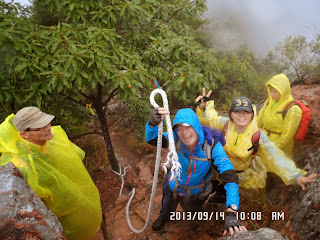
I took a group picture in spite of the rain. Soon we climbed a bit steep trail to the ridge. The heavy rain made trails like stream of water.
Some gaps on the trail looked like waterfalls.
After climbing up for 30 minutes to the ridge, we had a short break “Suzuki Time” as usual.
We saw a nice-looking pine tree, then soon we came to the summit of Galgisan.
From Galgisan to Seon-in-bong, the ridges were like manes of horse, rocky and slipperly, so we had to walk carefully.
We arrived at the summit of Seon-in-bong at 11:20, where we found an open space.
We opened our lunch boxes and had lunch there.
Fortunately, the rain became less and less at that time. We could have lunch more comfortably.
To my pleasant surprise, one of AhToSan members brought frying pan and gass burner, and another had brought pork belly and they began grilling the meat.
It is called “Samgyopsal” and we eat with vegetable. They really tasted good.
After grilling all pork, they began cooking rice with the same frying pan, it is called “Pokkeumpap볶음밥” or fried rice. We all liked this rice.
It was only 15 members, but all of us ate lunch together. So, I felt rather crowded.
We took a group picture after the lunch and resumed our hiking.
While climbing several peaks, some female members began picking up certain kind of mushrooms.
They are called “Ssari beoseok싸리 버섯” or “species of coral fungus” and in Japanese “Houkidakeホウキダケ.”
There are severl similar mushrooms and some of them are toxic mushrooms.
However, while having ridge walk, suddenly I got a cramp in my right leg.
The final peak called “Wolyongsan” was a bit rocky mountain, and it was necessary to use ropes to climb the summit.
While climbing the peak with rope, I got cramps on both legs.
I managed to climb to the summit and joined the group picture at the stone monument.
By that time, it completely stopped raining, and my cloths were getting dry.
On our way down from the last mountain, I noticed unique small mushrooms. They looked like flowers of cucumbers. In Korean, they are called “Oikko peoseok오이꽃버섯” which literally means flowers of cucumbers.
I could not find English or Japanese name for this mushroom.
We came down to the village at around 2:30. The first group members were waiting for slow hikers at a thatched roof gazebo.
When we all got together, we called the bus driver to pick us all. We were on the road next to the Geum River.
The bus driver picked us all and we asked him to go to a restaurant along the river.
There was a narrow bridge close to the river, and the bus driver skillfully drove the bus to the restaurant called “Namchun.”
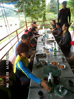
The tables under the roof were on the bank, and we could see a nice view of the Geum River.
First, together with many side dishes, they served grilled small fish on the frying pan called “Doribaengbaengi.” They tasted really good.
Then the main dish called “Ppakasari-tang” very spicy fish soup.
We drank beer and mageolli and ate such delicious food.
We spent nearly one hour for the wrap-up party, and finished the party at 4:00 pm.
Then I took the bus, but most of other members enjoyed walking across the river over the low bridge and then took a bus.
We came back to Daejoen at 5:30 pm. I went back to my studio apartment by using #606 bus.
I followed Minju’s advice that I boiled the “ssari-peoseok” and kept them in the water for a day, then cooked with duck meat.
I do not think it was especially tasty. Maybe I should use pork in stead of duck meat.
Anyhow, it was my 44th hike for this year and 325th hike as total AhToSan regular hike I participated.
--------------------------------------------------------------------------------------------------
分類:登山、韓国、秋山
登山日:2013年9月14日(土) 雨のち曇り。
登山地:忠北永同(충북 영동)「カルギ山(갈기산585m)聖人峰(성인봉624m)、月影山(월영산529m)
登山コース:簡易駐車場-カルギ山(갈기산) -馬のたてがみ稜線(말갈기능선) - 聖人峰(성인봉) - 月影山(월영)- 錦江の岸辺の道路(4時間 約6km)
参加者:アトサン15人
カルギ山(갈기산)は馬のたてがみ「말갈기」のようだという意味なので漢字表記はない。あえて日本語にすれば「たてがみ山」か。
以下、ネットからの引用「山の名前は、山の形勢が馬のたてがみと似ているので付けられ、岩が多く、ロッククライミングにぴったりな山である。尾根は半円形で、中央部が奥深い渓谷をなしている。梁山八景地域に属している。」
当初予定していた槐山(괴산)の楽輝峰(악휘봉)と馬糞峰(마분봉)は、この日は相当な雨が予想されるため急遽、より近場で安全なカルギ山~聖人峰~月影山山行に変更された。
参加人数は15人。このような天候でも山に登ろうと言う熱心な会員たちである。
また、バスは人数が少ないから小型バスを使うだろうという私の予想に反して、いつもの44人乗りに大型豪華バスで、アトサンの経営が心配になる。
また、いつもどおり1パックのお赤飯が配給され、今回はなんと2つもいただいた。
テジョンでは雨は小降りだったが、途中イムサム(人参)ランドの休憩ではかなり降っていて、登山地では写真撮影時はともかく、尾根を上がれば上がるほど土砂降りとなった。
私は数年前100円ショップで購入した傘をさして登ったが、これはカメラを守るという点で正解だった。
尾根に上がるための急坂の登山路はまるで小川のように泥流がながれ、段差のあるところはまるで小さな滝のようだった。
眼下の錦江が見える展望台まで上がるとやや小ぶりになったが、それでも11時ちかくまでは土砂降りが続き、下半身はもちろん登山靴の中もびしょびしょになった。
私は例の如く遅れがちだったが、歩き始めて30分ほどの尾根でなんとかスズキタイムに間に合った。
尾根に出てからすぐ立派な松の木で写真を撮ってからすぐ10時にはカルギ山の山頂に到着、石標と共に写真を撮った。
稜線歩き中にはけっこうおもしろいものも見た。めずらしいことだが、稜線の岩場で、ロープが切れた。これは使っている時だったら大変だが、ほとんどきれそうなロープを引っ張ったら切れたので、笑って済ませることができた。
また、稜線歩きの山の背の部分で、立派な里程標があり、片方はカルマ山、もう一方は聖人峰で、中心には「ガソリンスタンド」と書かれているジョークの里程標だ。(別のところでは、中心に「ホテル」と書かれていた。)
さらに、雨に濡れたきれいな野生花を見たが、中でもめずらしい「ダンギク」という花を見つけた。花が階層になって咲いている珍しい花だ。韓国語では『チュンコッナム(층꽃나무)』と言って文字通り「層の花」で、後でウェブで探してみると日本語名も『ダンギク』だった。日本、中国、韓国で見られる花で、英語名はなく、学名が"Caryopteris incana"と言うそうだ。
雨の中を「カルマ山」の文字通り馬のたてがみのような岩場を進み、聖人峰山頂のひらけた場所に着いたのは11時20分ごろだった。
ここで、昼食をとることにした。幸いなことにちょうどこのころ雨は食事に支障がないほど小降りになり、次第に止んできた。
ここでまた驚いたことに銀銃波が重いリュックからとり出したのはフライパンとガスバーナー、それに豚の三枚肉。なんと豪華なサムギョクサルの料理が始まった。
サムギョクサルは遠慮して3切れほどいただいただけにしたが、その後、野菜とお赤飯を加えて豪華なチャーハンまで作り始めた。
これはもうがまんならず、お握りを2個たべたうえであったが、私もかなりいただいた。
参加人数は15人でも、全員そろって食べればにぎやかだった。昼食後、全員そろって集合写真を撮ってから出発した。
聖人峰からさらに2,3の峰をあがったりおりたりしたが、この時、ミンジュやチョンダウンが「サリポソク」というももじゃもじゃしたキノコを採り始めた。
後で調べると日本語では「ホウキダケ」というキノコで私も簡単に見つけて採ることができ、空になった果物入れのパックにつめた。
しかし、後になってこの写真をアトサンのウェブに載せると、植物を良く知る『どんぐり』が黄色いホウキダケは毒があり、食べると下痢をするから茹でた後、数日水に浸して毒抜きをしなければならないと教えてくれた。
また、この他にも毒キノコを含む様々なキノコが豊富にあった。毒キノコの中では次の」ニガリクリタケ」は猛毒で、死亡例があるという。
さて、山行のほうは途中で片足が攣り、相変わらず最後を歩いた。それでも時々、前を行く会員に追いついた。
最後のピークは月影山で、この岩場をロープを使って登る時は両足が攣った。
それでもなんとか登って全員の集合写真に加わることができた。
この頃は雨もすっかり上がり、ずぶぬれになった下半身も乾いて来た。
最後の下山路では尾根で見た珍しいダンギクのほか、「オイコポソク(오이꽃버섯)」というキュウリの花に似たキノコが目についた。
このキノコはずいぶん小型で、アトサンの植物学者『どんぐり』によると『クェコリポソク』(꾀꼬리버섯ウグイスキノコ)という方が本名らしい。こちらの方は間違いなく食用キノコであるようだ。
当初月影山から、原点に戻るコースを想定していたが、錦江沿岸の食堂で打ち上げをするため、原点には戻らず、錦江のほとりへ下山した。
先頭グループが錦江支流のほとりの藁葺小屋で待っていて、そこに私が合流。最後にキノコ狩りをしていたグループが合流した所でバスを呼んだ。
全員そろったところで2時40分で、バスで錦江の対岸のナムチョン(南村?남촌)という食堂に向かった。
ここではつまみにトリペンペンイ(도리뱅뱅이)という淡水魚の小魚を丸く炒めた料理が出て、メインは「パカサリタン(빠가사리탕)というメウンタンを食べた。
打ち上げは3時に始まって4時過ぎまでたっぷりと食事も飲み物も堪能し、その後、私はバスに乗車したが、みんなは歩いて錦江をわたって対岸の遊歩道をあがってバスに乗車した。
バスに全員が乗車したのは4時半過ぎで、大田南門には5時半に戻った。
南門からの606番バスがすぐに来たため、ワンルームには6時に戻った。なかなか充実したハイキングとなった。
ホウキダケには似たキノコが何種類かあって、根本から箒状になっているものや、触るとすぐ崩れるようなのは食べられないキノコだという。
私が採取したのは根元から箒状になっていたのでこれだったかもしれない。
私はミンジュに言われたとおり、いったん鍋で煮込んでから水に1日浸して、その後、鴨肉をまぜて炒めたがあまりうまいものではなかった。豚肉の方が良かったかもしれない。
今年になって44回目で、325回目のアトサン定期登山は、わずか15人なのに44人乗りバスを使い、悪天候でも十分に楽しんだ登山となった。
I like hiking very much. I used to go hiking with a Korean hiking club named “AhToSan.” This blog introduces mostly my hiking activities in Korea and Japan, and Sydney in Australia. As of January 2020, I live in Sydney suburb. I go Blue Mountains and bush walk in Sydney area. 私は2003年から2014年まで韓国の大田(テジョン)に住んだ日本人である。11年間、週末は主に「アトサン山岳会」に参加した。14年4月に帰国したが、2020年以降はおもにシドニーで暮らし、時折、日本へ帰国する程度である。したがって最近の記事はSR(Sydney Report)としてブルーマウンテンのトレッキングを中心に書いている。
About pictures/当ブログ内の写真について/당 블로그내의 사진에 대해서
Most of the pictures in this blog are taken by my camera, yet some of them were downloaded from the website of the hiking club. If you click any pictures, they become the original size.
当ブログ内の写真の大部分は筆者のカメラで撮影したものですが、一部、山岳会の共有写真からダウンロードしたものを含みます。すべて、各写真をクリックすれば、元のサイズに拡大します。
당 블로그내 사진의 대부분은 필자의 카메라로 촬영한 것입니다만 일부 산악회 공유 사진으로부터 다운한 것도 포함합니다. 모두 각 사진을 클릭하면, 원래 사이즈에 확대합니다.
当ブログ内の写真の大部分は筆者のカメラで撮影したものですが、一部、山岳会の共有写真からダウンロードしたものを含みます。すべて、各写真をクリックすれば、元のサイズに拡大します。
당 블로그내 사진의 대부분은 필자의 카메라로 촬영한 것입니다만 일부 산악회 공유 사진으로부터 다운한 것도 포함합니다. 모두 각 사진을 클릭하면, 원래 사이즈에 확대합니다.
登録:
コメントの投稿 (Atom)


0 件のコメント:
コメントを投稿