Date: Nov. 2 (Sat), 2013
Mountain: Mt. Jiri, Manbokdae (1,433m)
Course: Seongsamjae – Goribong (1,248m) – Manbokdae (1,433m) – Jeongryangchi Service Area (8 km, 4 hours)
Participants: 45 AhToSan members
We had fine weather from Moday through Friday, but it became cloudy on Saturday, and later, it began to rain.
But we were thankful to God that it did not start raining until we finished the wrap-up party.
We left Expo South Gate Bus Stop at 6 am, I had to get up at 4 am and prepared for the hiking.
I packed rice into the new keep-warm-bottle, and carried a cup-noodle as well.
It was completely full, and a new member named “the 4th Batter” sat by me.
I concentrated into my study on the bus until we came close to Mt. Jiri.
The autumnal color at the foot of Mt. Jiri was beautiful.
We arrived at Seongsamjae at 9:13 am. It would be difficult to arrive at this time, even if I stayed overnight at Namwon on previous day.
The entrance of the trail to Manbokdae is just opposite of the entrance to Nokodan. We went back a little bit, then entered into the trail.
For the first 30 minutes, the trail was along the ridge, not steep at all.
But when I came close to the first peak called Goribong, the slope became a bit steep and I sweated a lot.
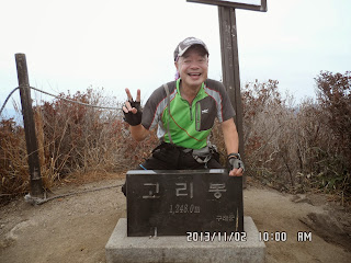
When I took the pictures at the Goribong monument, it was just 10 am.
I offered my fruits (grapes and small tomatoes) there. Two boxes became empty soon.
An old member of AhToSan, also offered sliced Paprika, too. I remembered her name, but I forgot her nice name.
From Goribong to Manbokdae, the trail was among silver grasses, and the slopes were gentle.
At about 11 am, Tempi said she became hungry, so we decided to have “Makgeolli Time.” Smile offered a big piece of bread. It tasted good.
The old female member also offered sliced persimmon. It also tasted good.
Jeongdaum offered Kimchi-jeon, it was good with makgeolli.
Then a new female member “Saengeuli” called me to take her pictures. She posed well. She became a good model for many photographers.
“Saengeul” in Hangul means “With a smile” so it is a good nickname.
We arrived at Manbokdae at 11:30. There was a big nice monument, so I took many pictures for AhToSan members.
We had lunch near the monument. The top group already went away, but most of the members had lunch together.
Since I arrived at the summit early, I finished my lunch early. So, I took extra pictures of “Autumn Diary” and “Tempi” and Saengli” pictures in the silver grass field.
When I finished taking extra pictures, Jeongjeong led the group of slow hikers.
I resumed the hike with fast hikers, and kept comfortable hike with them.
I could see blue sky for a short time at the monument of Manbokdae, but it soon became cloudy.
I felt as if I was walking in the cloud. When I came down the wooden stairs, it was “Jeongryongchi” service area.
There I caught up with the top group members, like Gonjapak and Mancha, etc.
I took pictures of the first group. But weather became worse and worse.
Anyway, at Jeongryongchi, when I cut some apple with knife, I cut my finger a little bit. Ruchi gave me a “band-aid” and it was quite helpful.
We were walking in the cloud, then Tempi said, “Let’s quit the hike and wait for the bus at Jeongryongdae.”
Actually it began to rain a little bit. So I accepted her proposal and went back to Jeongryongdae Service Area.
We waited for the bus, then took the bus and went to the final destination”Gogiri samgeori(고기리 삼거리)” by bus.
The driver stopped the bus at a Dam and we got off there to take pictures.
When the bus arrived at “Gogiri samgeori” there were “super fast” hikers there already.
The bus stopped near some maple trees with beautiful color of the leaves.
It stopped rain so we could have wrap-up party without problem.
When we almost finished the party, it began raining.
We finished the party at 3 pm and went back to Daejoen by 6 pm.
It was my 55th hike for this year, and my 330th AhToSan regular hiking.
---------------------------------------------------------------------------------------------------------
分類:登山、韓国、秋山,登山、智異山(지리산)
登山日:2013年11月2日(土) 曇りのち小雨
登山地:智異山国立公園「万福台」
登山コース:聖三峠(성삼재)休憩所〜小ゴリボン(작은고리봉1,248m)〜万福台(マンボクデ만복대1,433m)〜鄭嶺峙(ジョンリョンチ정령치)休憩所〜大ゴリボン(큰고리봉)〜コギリ三叉路(고기리 삼거리) 13km, 6時間[実際には鄭嶺峙で悪天候のためバスに乗りコギダムを経由してコギリ三叉路へ到着したのでたぶん8km、4時間のハイキングだった。]
参加者:アトサン会員45名。(外国人は私だけ)
この2週間と言うものは平日は毎日快晴の日が続いたが、今週はあいにく週末になって天気が悪化した。
それでもハイキングが終わって、打ち上げも終わるころに雨が降り出し、ハイキングそのものは快適に実行できた。
南門を6時に出発するため4時前から起きて準備した。
先週、ホームプラスで購入した円筒型弁当箱に飯をつめ、おかずは鴨肉とキムチを用意した。
さらに汁物としてカップラーメンと保温器も用意した。
バスは満席で座席は中間後方で、隣には初めて参加した若者「4番打者」が座った。
往路はEBSのリスニングに注力。しかし、智異山に近づくにつれ窓からみる紅葉がすばらしい。
個人で行こうとすれば鉄道利用で南原で前泊。南原のバスターミナルを一番のバスで出ても、この時間には到着できそうもない。
アトサンバスはソンサムジェに9:13に到着した。老姑壇がわにあるトイレを使ってから9:22に集合写真を撮り、老姑壇とは正反対の方向に向かって歩き始めた。
駐車場を出た先の道路を少し下った左側に「万福台コース」の登山口があった。
最初の30分ほどは緩やかなアップダウンのある尾根歩きで、最初の峰である小コリ峰(1,248m)に近づくにつれ上り坂がやや急となり、汗をかいた。
コリ峰の石標で撮った写真はぴったり10時になっていた。ここでのスズキタイムは時間も場所も大変適切だった。
先頭グループは先に行った後だったが、中間と後尾グループにブドウとミニトマトを提供し、2つのボックスが空になった。
また、アトサン初期によく登山し、今回、久しぶりに一人で参加した女性もパプリカを用意して提供した。
この後の万福台までのススキの原の登山路も緩やかで気分よく歩くことができた。
スズキタイムから1時間ほど過ぎた11時ごろ、テンピがお腹が空いたと言いだし、マッコリ休憩をすることにした。
スマイルがいつも持参する大きな菓子パンもおいしい。
チョンダウンが持参したキムチジョンもマッコリのつまみに最適。
久しぶりの女性会員もコリ峰に続いて甘ガキを提供した。
この後の万福台までの道も緩やかな上りで、先を行く黄色い帽子と黄色い服を着た女性は私を待って写真のポーズを取ってくれる。
笑顔の美しい女性だが、ニックネームは「セングリ생글이」であり、その名の通りニコニコする。
さて、万福台には11:30に到着した。立派な石標でしばらく写真撮影をしたが、アランドロン会長の鶴の一声で、その石標の下の空き地で昼食時間をとることにした。
先発隊は先に進んでいたが、我々中間グループが食べている間に、チョンジョンが面倒をみていた後尾グループも到着した。
ここでは時間が余っていると言う会長の勧めで、さらにススキの原を背景に、秋の日記とテンピ及び古いアトサンメンバーと新しいアトサンメンバーの女性で合計4人の写真を撮り収めた。
後尾グループの昼食風景を写したのが12:07で、さらに緩やかな尾根のトレッキングを続けた。
万福台の石標で一時見えた晴れ間は、その後なくなり、雲の中を歩くような気分になったが、整備された木の階段を下ると、「鄭嶺峙」という車道が通る峠に出た。
ここではついに先頭グループに追いついた。「マンチャ」が「鈴木さんがいるところをみると我々は後尾グループかもしれない」と冗談を言ったが、それでも先頭グループに追いついたのは気分がいい。
しかしそれとはうらはらに天気はどんどん下り坂。それまでリュックに入れてきたリンゴを出して、ナイフで切って分けようとしたとき、誤って左手中指を傷つけてしまった。
血が出たが、ルチがバンドエイドを持っていて、傷口に貼ってくれた。
その後、先頭グループの後について行こうとしたら、テンピが引き返そうと提案。
もともと最後尾グループ用に頼んでいたアトサンのバスに同乗することにした。
鄭嶺峙休憩所でしばらく休んでバスを待ち、アランドロン会長やスマイル、秋の日記たちと共にバスに乗った。
バスは途中、コギダムで小休止してから最終目的地であるコゴリ三叉路へ着いた。時間は2時ちょっと過ぎ位だった。
バスが目的地に着くのとほぼ同時に「4番打者」ら数人の超トップハイカーが到着した。
今回は13km、6時間を予定したのに、最後のハイカーも2時40分ごろ到着し、5時間ほどしかかからなかった。
打ち上げのメニューは辛いオジンゴの和え物で飲み物はマッコリが中心。
3時前には雨が降り出したこともあり、打ち上げを切り上げて帰路についた。
大田に戻ったのは6時ごろで、悪天候のためすっかり夜の雰囲気だった。小雨が降り続いていたがかまわず自転車でワンルームに戻った。
大変楽なハイキングで、この日のうちにアトサンのサイトへ写真をアップロードした。
今年55回目のハイキングで、アトサン定期登山は330回目である。
I like hiking very much. I used to go hiking with a Korean hiking club named “AhToSan.” This blog introduces mostly my hiking activities in Korea and Japan, and Sydney in Australia. As of January 2020, I live in Sydney suburb. I go Blue Mountains and bush walk in Sydney area. 私は2003年から2014年まで韓国の大田(テジョン)に住んだ日本人である。11年間、週末は主に「アトサン山岳会」に参加した。14年4月に帰国したが、2020年以降はおもにシドニーで暮らし、時折、日本へ帰国する程度である。したがって最近の記事はSR(Sydney Report)としてブルーマウンテンのトレッキングを中心に書いている。
About pictures/当ブログ内の写真について/당 블로그내의 사진에 대해서
Most of the pictures in this blog are taken by my camera, yet some of them were downloaded from the website of the hiking club. If you click any pictures, they become the original size.
当ブログ内の写真の大部分は筆者のカメラで撮影したものですが、一部、山岳会の共有写真からダウンロードしたものを含みます。すべて、各写真をクリックすれば、元のサイズに拡大します。
당 블로그내 사진의 대부분은 필자의 카메라로 촬영한 것입니다만 일부 산악회 공유 사진으로부터 다운한 것도 포함합니다. 모두 각 사진을 클릭하면, 원래 사이즈에 확대합니다.
当ブログ内の写真の大部分は筆者のカメラで撮影したものですが、一部、山岳会の共有写真からダウンロードしたものを含みます。すべて、各写真をクリックすれば、元のサイズに拡大します。
당 블로그내 사진의 대부분은 필자의 카메라로 촬영한 것입니다만 일부 산악회 공유 사진으로부터 다운한 것도 포함합니다. 모두 각 사진을 클릭하면, 원래 사이즈에 확대합니다.


0 件のコメント:
コメントを投稿